Peak Akksu (N.), 5217 m, center of N. face (Chaplynsky, 1988), Cat. 6B
Pamir-Alay, Turkestan Range, Laylyak gorge. 5.4.2.6
Ascent Passport
- Technical class
- Pamir-Alay, Laylyak gorge, Turkestan Range
- Peak Akksu (N.) 5217 m via center of N. face (Chaplynsky, 1988)
- Category 6B difficulty. 4th ascent.
- Height difference — 1467 m.
Distance — 1910 m. Distance of sections with 5–6 cat. diff. — 1350 m. Average steepness of the route (face) — 74°
- Pitons driven:
| rock | chocks | bolt | ice |
|---|---|---|---|
| 113 / 60 | 183 / 91 | 12x / 10 | 71 |
x — previously driven pitons reused
- Total climbing hours — 67, days — 8
- Overnights: R1–R6 in a platform-tent
R7–R8 in a tent on a ridge platform
-
Team leader: Shabalyn Pavel, MSМК, 610006, Kirov, Eduardovicha Nekrasova st., 6"A"-36. Team member: Tukhvatullin Ilyas, MS, Tashkent, Syrdarya-Lamidovich inskaya st., 3"A".
-
Coach: Shabalyn Pavel Eduardovich
-
Approach to the route — July 26, 1996.
Summit — August 2, 1996. Return — August 3, 1996.
-
Sports club "RODINA" of Kirov regional sports committee, 610005, Kirov, Lepse st., 4"A"
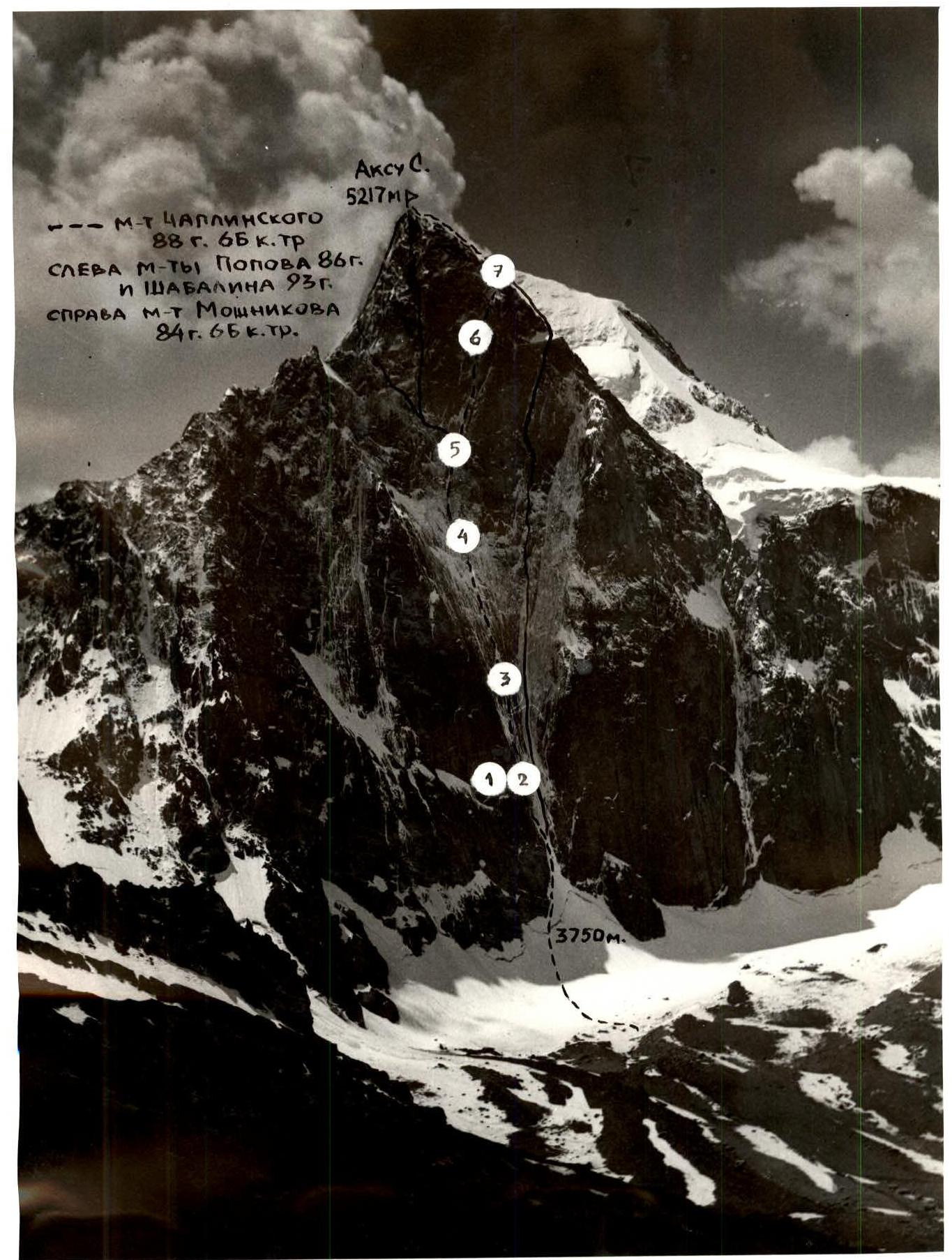
 General photo of Akksu (N.) 5217 m summit. Taken on July 29, 1996.
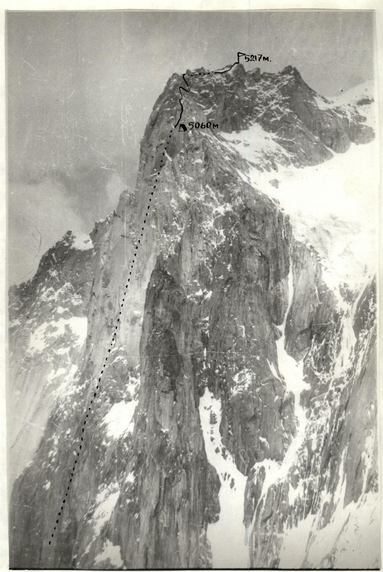
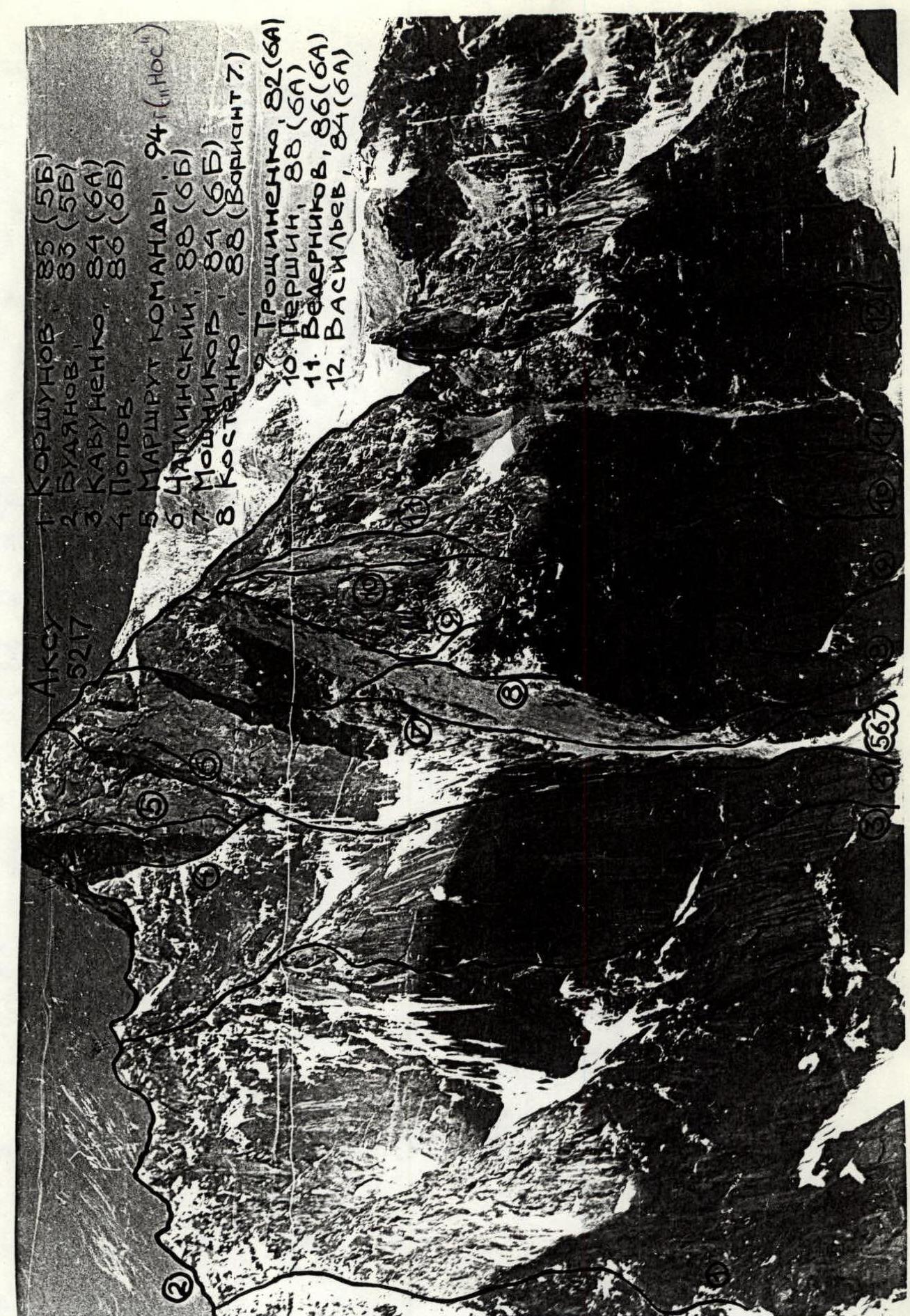 Photo of the face profile from the right from "Admiralteets" pillar.
Panorama of the area. Taken on July 29, 1993 from p. Akksu from a distance of 5 km. Height 2960 m. Shooting point # 4. "Zenit" camera. "Helios" 44-M – 4.2/58 lens.
Tactical Actions of the Team
The overall ascent pattern is typical for a two-person team on an extended wall route. The leader climbs without a backpack on a double rope, one tested by UIAA, sets up a belay station on three (minimum) linked anchors, the second climber follows on the belay rope with upper protection, one backpack is hung using the American method, the platform is carried disassembled on the back, and the second backpack is pulled up. Leader change — daily. Nutrition:
- Hot meals in the morning and evening.
- Individual snacks during the day.
Technical techniques and equipment are standard, except for the extensive use of ice screws on ice and rock. Overnights:
- On the wall — in a platform-tent, in safe places under overhangs.
- On the ridge — in a tent. There were no "working" falls or injuries. No radio contact with the base, no rescue team below. The team operated in a completely autonomous mode.
Day 1: Started at 6:00. Stopped for the night at 15:00 under an overhang at the designated spot. Processing impossible — water pouring from the overhang. Day 2: Started at 8:00. Processed until 14:00 — two ropes, rock in ice. Descended to the overnight spot. No point in pushing on — it starts raining at 15:00, and the next overnight spot is still three ropes away. Day 3: Working from 8:00. Covered the belay rope + three ropes. Stopped for the night at 15:00 under an overhang. Raining. Processing impossible. Day 4: Started at 8:00. Working in water the whole day (and subsequent days). Consistently warm, water doesn't freeze even at night. Specific conditions:
- Ice rivers are undercut by water and simply lie or hang in the chimney.
- Ice is waterlogged, loose, wet.
- Climbing is extremely cautious.
- Problems with setting up belays — water flows over the rock, ice is unreliable.
At 15:00 reached a snow patch. Until 19:00 covered another two ropes. Over-nighted under an overhang. Dried gear until midnight. Continued raining at night, ice falling. Day 5: Started at 9:00. Climbing on wet rocks, hanging ice crusts. Everything is very unreliable. Again got wet from the morning. Covered five ropes. Stopped for the night at 19:00 near the Popov–Chaplynsky fork. Dried gear until 1 am. Day 6: Started at 9:00. Still raining. Wet ice alternates with wet rocks. Climbing is extreme, problems with setting up belays. Stopped for the night at 17:00 near the entrance to the crack. Water gushing inside. Further progress is not safe. Dried gear all night. Day 7: Started working at 9:00. Route conditions remain the same. Reached the ridge at 20:00. Dried gear at night. Day 8: Started at 11:00. Reached the summit at 15:00. Descended from the tower at 20:00. Over-nighted on a snow ledge. Day 9: Descended to base camp at 22:00.
The route was completed despite unfavorable conditions. Factors contributing to the successful ascent:
- Camping gear was carried in backpacks in airtight packaging.
- On overnights, the platform was covered with polyethylene.
- Sufficient gas and food supplies allowed for drying and recovery during overnights.
- Special ice training during winter trips to France in the past two years and experience climbing frozen waterfalls enabled the team to progress relatively quickly and with a high degree of reliability.
Route Diagram
| Sect. | Ice | Chocks | Pitons | Bolt | Length, m | Cat. diff. | Steepness, ° | Date |
|---|---|---|---|---|---|---|---|---|
| R1 | 3 | 3 | 2 | 80 | 4 | 30–60 | ||
| R2 | 4 | 5 | 40 | 6 | 70 | |||
| R3 | 4 | 40 | 4 | 60 | ||||
| R4 | 15/12 | 10/10 | 40 | 6 | 85 | |||
| R5 | 10/7 | 7/5 | 45 | 6 | 80 | |||
| R6 | 9/6 | 4/2 | 1x | 45 | 6 | 90 | 26–27.07 | |
| R7 | 7 | 3 | 40 | 5 | 80 | |||
| R8 | 10 | 2 | 40 | 5 | 80 | |||
| R9 | 9 | 4 | 40 | 5 | 80 | |||
| R10 | 15/10 | 5/3 | 2x | 45 | 6 | 85 | ||
| R11 | 12/8 | 7/5 | 2x | 30 | 6 | 85 | 28.07 | |
| R12 | 7/7 | 3/3 | 1x | 30 | 3 | 80 | ||
| R13 | 6 | 3 | 40 | 5 | 70 | |||
| R14 | 4 | 7/7 | 8/8 | 1x | 45 | 5 | 85 | |
| R15 | 3 | 5/5 | 6/6 | 2x | 45 | 5 | 80 | |
| R16 | 4 | 1 | 1x | 40 | 5 | 70 | ||
| R17 | 4 | 45 | 5 | 60 | ||||
| R18 | 5 | 4 | 45 | 5 | 75 | |||
| R19 | 7/5 | 4/3 | 35 | 6 | 80 | |||
| R20 | 10/10 | 6/5 | 45 | 6 | 90 | 29.07 | ||
| R21 | 5 | 3 | 40 | 5 | 85 | |||
| R22 | 5 | 45 | 5 | 70 | ||||
| R23 | 5 | 45 | 5 | 70 | ||||
| R24 | 2 | 5 | 3 | 35 | 6 | 80 | 30.07 | |
| R25 | 4 | 45 | 5 | 70 | ||||
| R26 | 5 | 45 | 5 | 70 | ||||
| R27 | 4 | 1 | 1 | 45 | 5 | 70 | ||
| R28 | 3 | 3 | 2 | 45 | 6 | 75 | ||
| R29 | 7/5 | 4/3 | 45 | 6 | 80 | |||
| R30 | 5 | 1 | 1x | 45 | 6 | 75 | ||
| R31 | 5 | 5/3 | 3/3 | 50 | 6 | 80 | ||
| R32 | 4 | 1 | 50 | 5 | 70 | |||
| R33 | 3 | 50 | 4 | 65 | ||||
| R34 | 2 | 30 | 4 | 65 | ||||
| R35 | 2 | 3 | 2 | 50 | 5 | 75 | ||
| R36 | 12/6 | 10/4 | 450 | 6 | 60 | 01.08.1996 |
Route Description by Sections
R0–R1. From the bergschrund, an ice river leads to a rock gorge. R1–R2. Ice-covered rocks lead to the Moshnikov ice river. R2–R3. Along the ice, pressing against the left rocks, to the base of the wall. R3–R5. Vertical slabs with fissures. Water flows, turns into a waterfall by evening. Challenging climbing with ITO. To the right of the overhang, an overnight spot on bolted pitons. A safe place under a ceiling. R5–R9. The overhang is tackled head-on. From here begins a giant internal corner — a chimney. Gets flooded with water after noon. Tense climbing. R9–R10. Challenging ITO rope. To the right of the chimney, under a small overhang, bolted pitons for a platform. R10–R11. Challenging ITO. The overhang is bypassed on the left or via a vertical ice icicle with an overhanging section. R11–R15. Chimney-corner. Live rocks present. At the end of the section, to the right on a long sloping ledge, an overnight spot. R15–R17. A steep ice river leads to a snow field. R17–R18. Slabs, small, quartz-filled cracks, ice-covered. R18–R20. A vertical internal corner turns into a crevice. Steep. Challenging ITO. Live rocks present. R20–R21. The crevice leads to the "cross" — a two-meter quartz vein. Tense free climbing. Above the "cross", to the left under an overhang, bolted pitons for an overnight spot. R21–R23. Very steep frozen ice river. In places, just a crust of ice on rocks. R23–R28. Ice river, with occasional rock outcrops. R28–R29. The river breaks into rivulets. Rocks have a blocky structure, live rocks. Steep. R29–R30. Move left under the wall. A steep slab with a crack for ITO abuts a ceiling. Overnight spot. R30–R31. Move right around the corner and then left up a ice-covered corner to the stop. R31–R32. The "highlight" of the route. An overhanging corner with a ice-filled crack. R32–R33. Ice river with rock outcrops. R33–R35. Ice field. R35–R36. Steep internal corner, ice-covered with live rocks. Exit to the ridge. A good ledge for an overnight spot. R36–Summit. Unpleasant ridge with bypasses and rappels. In places, ITO.
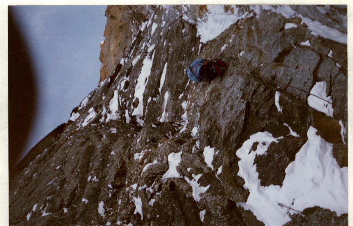 Section R3–R4, cat. diff. 6. The overhang is visible at the top.
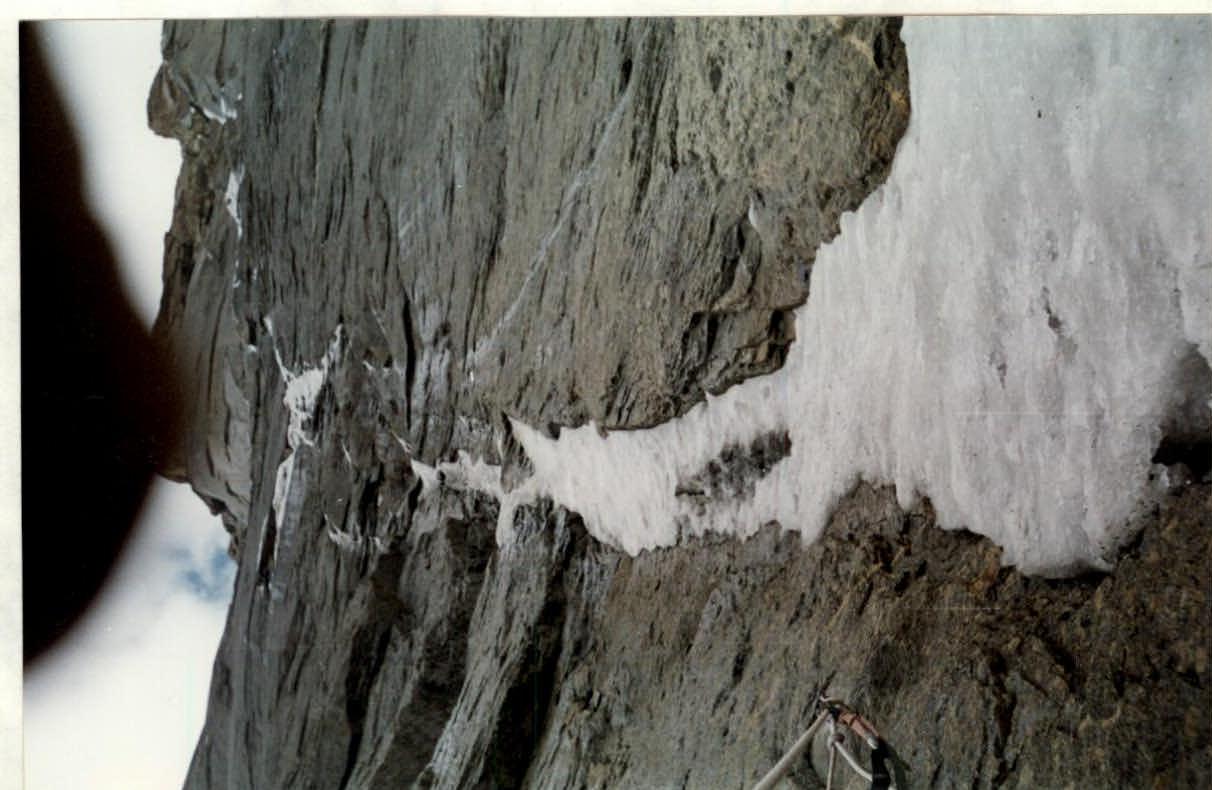 Section R17–R18, cat. diff. 5.
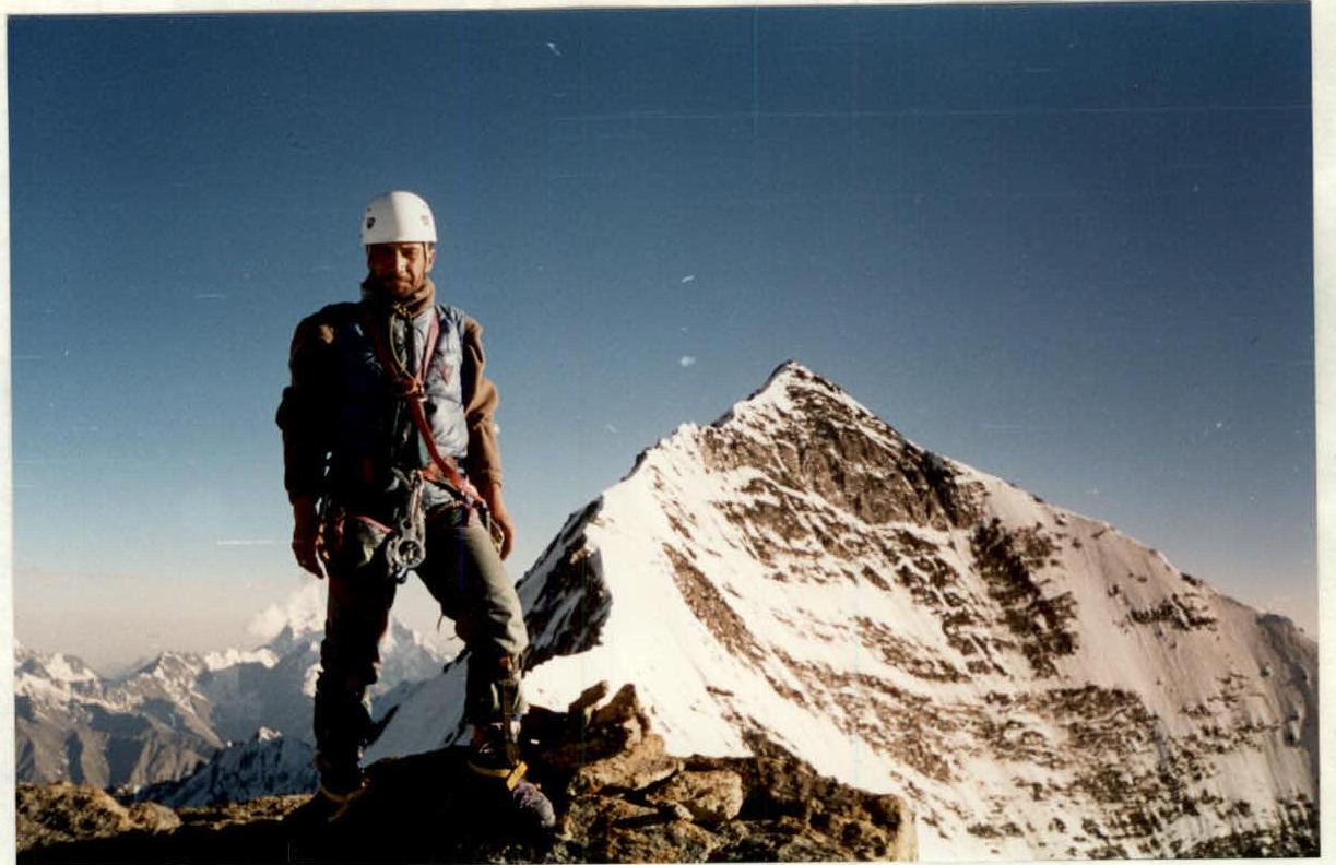 Photo at the summit near the control post.
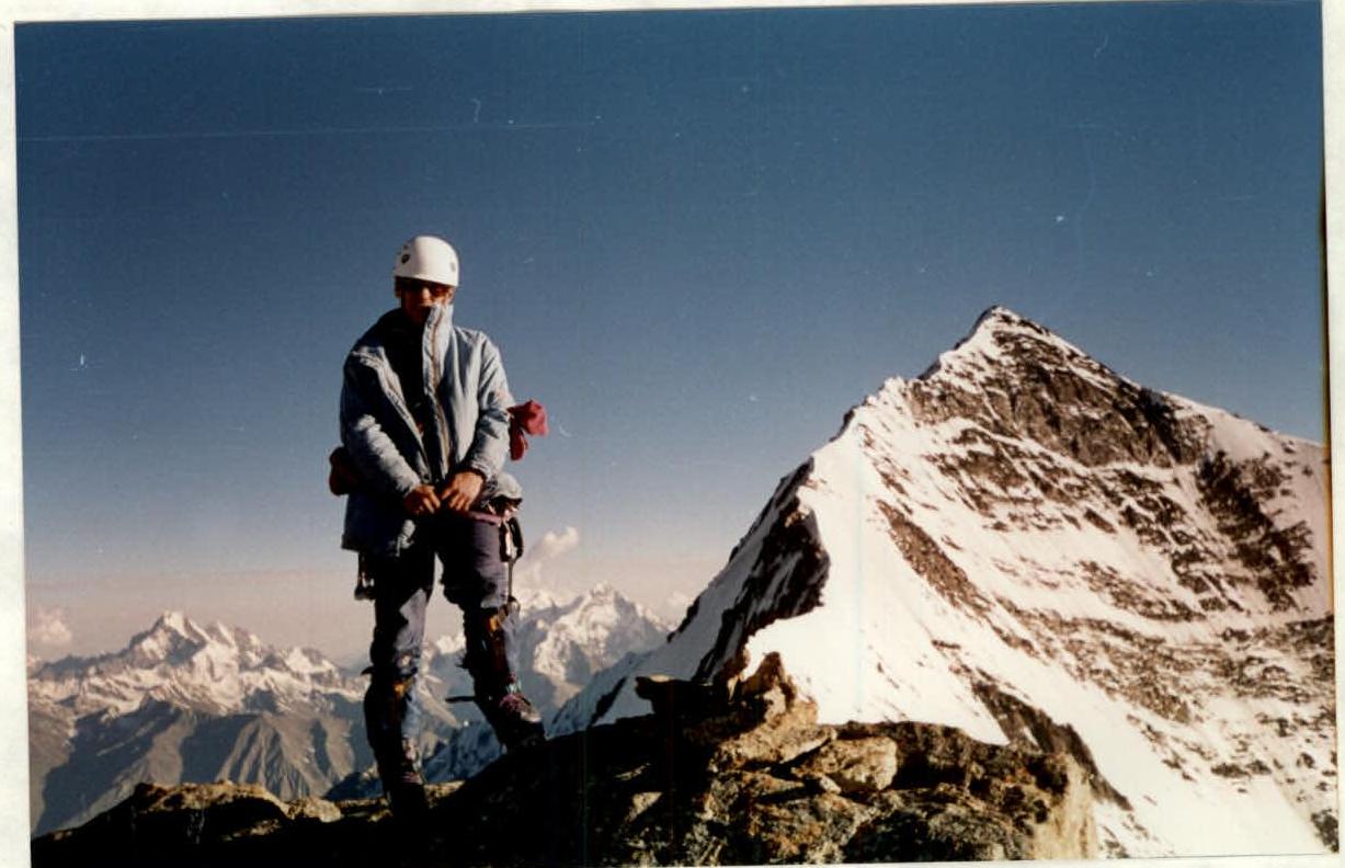 Photo at the summit near the control post.