ASCENT DOCUMENT
-
Ascent class — rock climbing.
-
Ascent area, its height, ascent route — Mt. YUBILEYNAYA, 3600 m, via the northern ridge.
-
Proposed difficulty category — 1B.
-
Route characteristics:
height difference — 700 m, total route length — 900 m, average steepness — 35°.
-
Pitons hammered in:
for belaying — 4 pcs.
-
Number of climbing hours — 6 hours.
-
Number of overnight stays and their characteristics: none.
-
Surname, name, patronymic of the leader and their qualification:
- Fevziev R.F., leader, Master of Sports of the USSR.
- Mumdzhi T.M., participant, Master of Sports of the USSR.
- Maksimenko V.A., participant, 3rd sports category.
- Manukyan T.Kh., participant, sports category.
-
Team coach: Mumdzhi T.M., Master of Sports of the USSR, instructor-methodologist 1st category.
-
Date of departure on the route and return:
departure — May 4, 1981, return — May 4, 1981
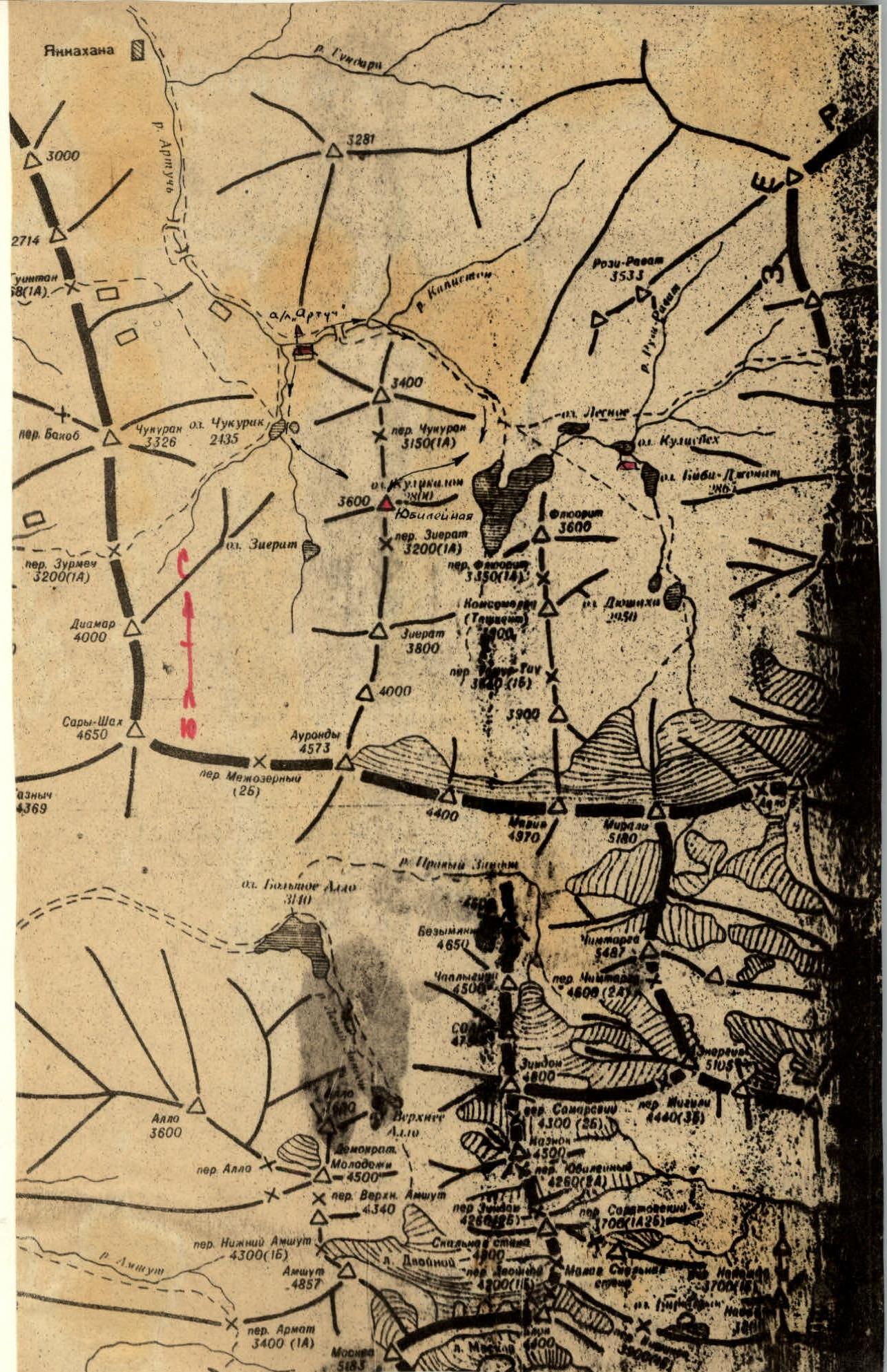
ASCENT AREA MAP-SCHEME
BRIEF DESCRIPTION OF THE ROUTE
From the Artuch alpine camp along the trail in the direction of Kulikalon lakes, when reaching the Kulikalon plateau — turn right along the trail towards the Big Kulikalon lakes. To the right, a large main couloir is visible; move along the right part of the couloir, then — to a grassy slope, which leads to the northern ridge of Mt. Yubileynaya.
Second approach option: from the Artuch alpine camp along the trail to Chukurak lake, then — turn left along the trail to Chukurak pass. When ascending to the pass (initially) a large scree-grassy couloir is visible to the right, which descends from the northern shoulder of Mt. Yubileynaya. One can:
- ascend via the couloir;
- or reach Chukurak pass and move along the northern ridge to the start of the route.
The approach in both cases takes 2.0–2.3 hours.
Along the scree-damaged ridge, there are rock outcrops in some places. We approach a large gendarme.
Length 100–120 m, steepness 20°. The large gendarme is bypassed on the right.
- Initially, 10 m along a steep slab, steepness 45° — exit under the base of the gendarme.
- Then along a narrow ledge 20 m — the ledge leads to a large internal corner (40–45 m).
- The corner is climbed on the left side, with piton belay.
- In May-June, the corner is filled with snow, with ice in some places.
The corner leads to a large scree ledge, then along the pre-summit ridge, sometimes simultaneously, sometimes in turns — exit to the summit. Length 200–250 m, steepness 25°.
Descent is done via the ascent route; in the internal corner, the group descends using sport climbing techniques or rappelling, the latter with bottom belay.
The entire route takes 6 hours.
TABLE OF MAIN ROUTE CHARACTERISTICS

Descent is done via the ascent route.
Note: reaching Chukurak pass or the shoulder before the route is straightforward. Ascent length — 450–500 m, steepness 20–25°.