
5Б cat. diff. 540 m, October 9, 1984
RSFSR Championship. First Ascent Class
Alai Range. Gaumysh Main (5367 m) via the center of the "rhombus" on the North face
Team of the Rostov Regional Sports Committee
Senior coach of the team — MSMS Yuri Y. Arcishevsky Team captain — CMS Alexander G. Pogorelov
1984
344029, Rostov-on-Don, ul. 1st Konnaya Armiya, 4, T/A "Planeta" club. Phone: 52-20-70. Club Director — Ernest L. Mereckiy. 344010, Rostov-on-Don, ul. Krasnoarmeyskaya, 63/3, apt. 70, Yuri Y. Arcishevsky. Home phone: 32-02-16. 344032, Rostov-on-Don, ul. Kazanskaya, 85/2, apt. 155, Alexander G. Pogorelov.
Please direct any inquiries regarding the report to the above address.
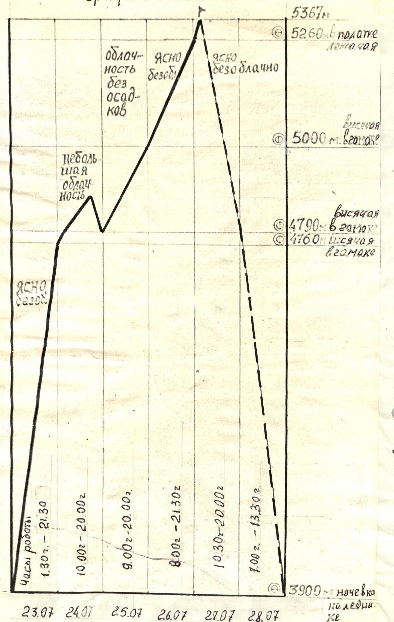
The heights mentioned in the report were measured using an altimeter.
Brief Overview of the Area
The ascent object — Mt. Gaumysh Main (5367 m) is located in the northern spur of the Alai Range, south of Khaydarken. The Alai Range, from Mt. Tandy-Kul in the west to the Kard-Kazyk pass in the east, forms a complex orographic mountain country with numerous spurs. One of these spurs, north of the Alaudin pass, is home to Mt. Gaumysh Main (5367 m), a nodal peak from which two significant ridges extend westward. The southern ridge separates the Hodjaachkan river valley (a tributary of the Sokh river) from the Gaumyn river valley, where a large glacier is located. The ridge leading westward connects to Mt. Gaumysh (5200 m) and further to Mt. Gaumysh (5100 m). The uniqueness of this area lies in the presence of walls with different exposures and characteristics within a single cirque, ranging from a "warm" eastern wall on Mt. Karaganda (4800 m) to a harsh, icy, and shaded northern wall of the Gaumysh massif. The northern wall was first ascended in 1977 by a Leningrad team led by Gorenchuk, who climbed Mt. Gaumysh (5200 m) and received gold medals at the 1977 USSR Championship. The route was classified as 6B cat. diff. In 1980, a second route was established on Mt. Gaumysh (5200 m) by a Sverdlovsk team led by S. Yefimov, also earning gold medals at the 1980 USSR Championship. Subsequent routes on the Gaumysh massif ranged from 4B to 5B cat. diff. On Mt. Gaumysh (5100 m), Leningrad climbers established a 5B cat. diff. route to the right of Yefimov's route. On Mt. Gaumysh Main (5367 m), climbers from the "Alai" camping ground ascended via 4B and 5A cat. diff. routes. However, the "rhombus" on the northern wall of Mt. Gaumysh Main (5367 m), a long-standing target for many leading climbers, remained unascended until 1984 when a Krasnoyarsk team pioneered a route to the left of the "rhombus".
The region's climate is moderately continental. The approach to the glacier cirque is straightforward: from the end of the road in the Alaudin valley (20 km from Khaydarken), follow the trail over the Gaumysh dry pass (4075 m) for 5–6 hours to the glacier tongue. From there, it takes an additional 2–3 hours to reach the start of the route, initially following a moraine trail and then a gentle glacier.
Preparation for the Ascent
Preparation for the ascent within the framework of the RSFSR Championship in the first ascent class began in the fall of the previous year after selecting the ascent object.
The primary option considered was ascending Mt. Gaumysh Main (5367 m) via the central part of the "rhombus" on the North face.
The secondary option was to ascend Mt. 5100, to the right of Yefimov's route on Mt. 5200, which was later discarded due to safety concerns.
The coaching council, led by senior coach Yuri Y. Arcishevsky, developed a plan for physical and tactical-technical preparation. General physical preparation (GFP) included:
- Cross-country training with a peak in March (Rostov-Taganrog 73.5 km run);
- Circuit training on gymnastic equipment;
- Running on stadium tiers;
- Fartlek.
A significant portion of time was dedicated to working on natural rock formations in s. Zaitsevka and an artificial rock climbing wall at the club.
In the spring, the focus shifted to climbing routes in pairs on complex rock terrain using I.T.O. and "sky-hook," traversing on jumar with a backpack, swinging traverse, and coordinating pairs' movements, as well as organizing hammock bivouacs.
In May, 5B cat. diff. ascents were planned, but the alpinad did not take place due to circumstances beyond their control. Nevertheless, a training camp was held on the rocks of s. Zaitsevka (70 km from Shakhty, rock height up to 27 m, steepness 85–95°).
Acclimatization and training ascents were conducted in the Caucasus, where team candidates climbed Mt. Ullu-Kara, Volnaya Ispaniya, and Galdor Main (third ascent), which was the starting point for traversing the Sugansky ridge, earning "gold" at the USSR Championship. All routes were 5B cat. diff.
Information about the area and ascent object was gathered from previous expeditions. Additional information was obtained in Osh at the KSP Alai District and KSP Pamiro-Alai District.
At the base camp, the team received consultation from a Krasnoyarsk expedition regarding the state of the entire wall, the "rhombus," and its terrain. By this time, the Krasnoyarsk team had already completed a first ascent on Mt. Gaumysh Main (5367 m).
From July 19 to 21, the team observed the wall and finalized the route via the "rhombus."
The observation yielded the following results:
- The wall was completely clear of snow.
- The ice cap to the right of the "rhombus" was in a calm state.
- Falling ice was observed from the left icefall, but it was significantly to the left of the planned route.
- No regular, intense rockfall or icefall was observed in the "rhombus" area, except for the gully on the left ice slope.
- The lower part of the route posed the greatest potential danger, necessitating a quick passage in the first half of the day as intense rockfall and icefall began around 15–16 hours.
- The "rhombus" presented a sheer monolithic wall with three chimneys, requiring primarily shovel work.
Based on the entire preparation period and training ascents, the coaching council recommended seven individuals for the ascent. However, considering the route's nature and safety concerns, the team size was finalized at four.
Tactical Actions of the Team
The tactical plan for the ascent was developed based on information gathered during the pre-season from Moscow and Leningrad climbers, the USSR Sports Committee, consultation with Krasnoyarsk climbers who attempted the "rhombus," and the team's own observations.
The tactical plan considered the following features of the chosen route:
- The key part of the route is located from 4600–4700 m and represents a sheer monolithic wall with three wide chimneys filled with ice. The most likely passage is through one of these chimneys; elsewhere, significant shovel work is required.
- The lower part of the route (sections R0–R18) posed the greatest danger due to rockfall and icefall, particularly in the second half of the day, starting around 15:00.
- To the right of the "rhombus," an icefall was present in the upper part of the wall. No icefall was observed during the stay of the Krasnoyarsk team or our own stay. Ice falling from the left icefall did not affect the chosen route.
- In bad weather, the rocks become covered in ice.
The following measures and tactical actions were taken:
- The team decided to start the route only in good, stable weather, as the presence of ice makes the ascent highly challenging. Additional equipment was taken for potential evacuation, including more ice stoppers and extra ropes for rappelling in the chimney.
- Shlyambrur hooks (2 pcs.) and shlyambrur pitons (30 pcs.) were taken for reliable belay organization.
- Ice stoppers were manufactured in advance and performed well during the ascent.
- Departure at 1:30 AM, reaching the first rock bastion by 5:30 AM.
- To avoid potential icefall from the right icefall, the team chose a more challenging but protected path (section R6–R12).
- On section R14–R16, the team moved to the right of the gully to avoid falling rocks, and later had to traverse complex rocks as the ice route followed the gully.
- For reliable belay organization, the team followed a chimney filled with ice, as the rocks were monolithic with few cracks for pitons.
- On the belay points above the anchor, a backpack was secured to serve as protection against falling rocks or ice.
The first day required 20 hours of work due to the need to traverse the lower part of the route. To rest, the team began work the next day at 10:00.
All three bivouacs on the wall were hammock bivouacs. Shlyambrur pitons were used to organize the bivouacs and ensure reliable belay.
The second bivouac was set up 40 m above the first, at the end of section R23–R24, which was covered in ice, allowing the use of ice screws for belay organization.
The team had to deviate from the planned route while ascending the upper part. After traversing left from the end of section R37–R38, they decided to return as they encountered overhanging rocks and a large ice "icicle" with water flowing and ice debris falling from it.
Returning to the end of section R37–R38 and consulting with observers via radio, the team ascended the chimney.
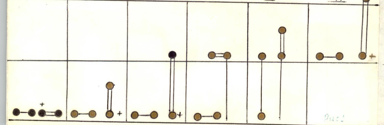
Except for sections R1–R2, R42–R44, and R45–R48, the team traversed the entire route using rappel lines. The technique used is illustrated in the figure.
The first climber in the first rope works on a double rope.
The second climber in the second rope ascends the rappel lines with top-rope belay.
The first climber in the second rope ascends the rappel lines with a Prusik knot, organizing additional (lower) belay through driven pitons.
The second climber from the second rope ascends the rappel lines with top-rope belay and removes pitons.
On ice sections, the second climber from the first rope removed unnecessary pitons for belay.
The change of lead climber during the ascent is shown in the table.
| Section | Lead Climber | Section | Lead Climber |
|---|---|---|---|
| Pogorelov | R18–R19 | Selin | |
| autonomously | R19–R20 | Piatnitsyn | |
| R2–R3 | Piatnitsyn | R20–R22 | Selin |
| R3–R4 | -/- | R22–R36 | Pogorelov |
| R4–R5 | Pogorelov | R36–R37 | Piatnitsyn |
| R5–R6 | -/- | R37–R38 | Beletsky |
| R6–R11 | Beletsky | R38–R42 | Selin |
| R11–R13 | Pogorelov | R42–R43 | Beletsky |
| R13–R16 | Selin | R43–R44 | -/- |
| R16–R18 | Piatnitsyn | R44–R45 | Piatnitsyn |
Total climbing hours: 55.
Climbing hours: 12.
Bivouac at the end of section R23–R24.
Total climbing hours: 55.
Climbing hours: 12.
Route Description in UIAA Symbols
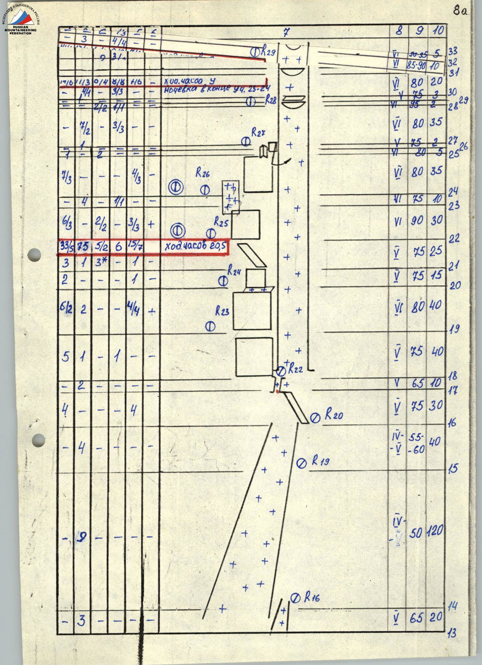
| Rock Pitons | Ice Pitons | Shlyambrur Pitons | Ice Stoppers | Rock Stoppers | Sky-hook | Section (R) | Cat. Diff./Steepness, ° | Length, m | Section (Text) |
|---|---|---|---|---|---|---|---|---|---|
| R15 | V 70 | 10 | |||||||
| 6/3 | 2/2 | 3/3 | + | R14 | VI 90 | 30 | |||
| 2 | 4 | V 70 | 30 | ||||||
| 2 | 1 | VI 80 | 5 | ||||||
| 2 | 1 | R13 | V 75 | 10 | |||||
| 7 | V 65 | 20 | |||||||
| R12 | V 70 | 5 | |||||||
| 2 | 4 | 2 | 1 | 70–75 | 40 | ||||
| R11 | |||||||||
| 7 | 3 | R10 | VI 85 | 40 | |||||
| IV–V 55 | 80 | ||||||||
| 8 | R9 | ||||||||
| IV 50 | 240 | ||||||||
| R2 | |||||||||
| 3 | R1 | III 45 | 40 | ||||||
| 5 | R0 | V 80 | 30 | ||||||
| 3 | R29 | VI 80–95 | 5 | 33 | |||||
| 4/4 | V 85–90 | 10 | 32 | ||||||
| 93/ | V 80 | 20 | 31 | ||||||
| 17/6 | 113 | 0/4 | 8/8 | + | R28 | V 75 | 3 | 30 | |
| 3/3 | VI 95 | 2 | 28 | ||||||
| 4/4 | VI 80 | 35 | 29 | ||||||
| 2/2 | 1/1 | R27 | V 75 | 2 | 27 | ||||
| 7/2 | 3/3 | V 80 | 5 | 25 | |||||
| 7 | VI 80 | 35 | 26 | ||||||
| 7/3 | 4/13 | R26 | VI 80 | 35 | 24 | ||||
| V 75 | 10 | 23 | |||||||
| 24 | 4 | 2 | 1 | VI 90 | 30 | 22 | |||
| R25 | |||||||||
| 6/3 | 2/2 | 3/3 | + | V 75 | 25 | 21 | |||
| 33/5 | 75 | 5/2 | 6 | 15/7 | V 75 | 15 | 20 | ||
| 3 | 1 | 3* | 1 | R24 | V 75 | 15 | 19 | ||
| 2 | 1 | VI 80 | 40 | 18 | |||||
| 6/2 | 2 | 4/4 | + | R23 | V 75 | 40 | 17 | ||
| V 65 | 10 | 16 | |||||||
| 5 | 1 | 1 | R22 | V 75 | 30 | 15 | |||
| IV–V 55 | 40 | 14 | |||||||
| 4 | 4 | R20 | V 60 | ||||||
| R19 | IV–V 50 | 120 | 13 | ||||||
| V 65 | 20 | ||||||||
| 9 | R16 | ||||||||
| 3 | |||||||||
| IV 50 | 160 | ||||||||
| R37 | 44 | ||||||||
| 1 | 1 | IV 70 | 40 | 43 | |||||
| 2 | VI 90 | 5 | 42 | ||||||
| 7 | 4/3 | R34 | VI 80 | 35 | 41 | ||||
| 33 | 4/3 | R33 | VI 90 | 10 | 40 | ||||
| 63 | 4/3 | VI 80 | 30 | 39 | |||||
| 63 | 4/3 | VI 75 | 40 | 38 | |||||
| 61 | 4/3 | R32 | V 75–80 | 40 | 37 | ||||
| 42 | 5/2 | 14 | 7/2 | 6/3 | |||||
| 4 | 1/4 | 3* | 1/4 | 2/2 | R31 | VI 75 | 40 | 36 | |
| 5/4 | 2/4 | 3/3 | + | VI 80 | 40 | ||||
| 311 | 4/3 | + | R30 | VI 90–92 | 10 | 35 | |||
| 4/1 | 2/2 | V 75 | 25 | 34 | |||||
| 4/1 | 2/2 | V 80 | 25 | 33 |

Route Description by Sections
R0–R1. Ice wall formed by a bergschrund and a system of fractures with an average steepness of 80°. In some areas, the steepness reaches 90°. Ascended using "ice-fifi." Ice screw belay.
R1–R2. Ice slope with a steepness of 45°, partially covered with hard firn. Cat. diff. 2.
R2–R3. Ice slope with a steepness of 50°. Ice screw belay.
R3–R4. Ice slope with a steepness of 55°. Ice screw belay.
R4–R5. Wide chimney with a steepness of up to 85°, filled with hard ice. Ice thickness ranges from 4 to 30 cm. Belay using ice stoppers and ice screws. "Ice-fifi" used for ascent.
R5–R6. Wide chimney with a steepness of up to 75°, filled with ice. Belay using ice screws and ice stoppers.
R6–R7. Traverse left 5 m along a monolithic rock wall with minimal holds.
R7–R8. Continue left along a steep ice shelf to a chimney filled with ice. Belay using ice screws. "Ice-fifi" used for ascent.
R8–R9. Chimney filled with very hard ice, ending in a rock wall. "Ice-fifi" and ice axe used for ascent. Belay through ice screws.
R9–R10. Rock wall with a steepness of 85°, featuring very small holds and crumbling rocks. No cracks for pitons. Belay possible at the top of the wall.
R10–R11. Indistinct rock ridge (separating the main gully from the chimney) with a steepness of up to 70°. Few cracks for pitons. Rock character similar to the previous section.
R11–R12. Sheer wall, partially overhanging. Minimal holds. Monolithic rocks with few cracks for pitons. Used petal pitons, "mizer" stoppers, "sky-hook," and shlyambrur pitons. I.T.O.
R12–R13. Wall with a steepness of up to 70°, covered in ice. Transition from rocks to ice is challenging, using I.T.O. (ice stoppers). Belay through ice screws, initially hammered into the ice.
R13–R14. Steep ice gully leading to an ice slope. Hard ice. Belay through ice screws.
R14–R15. Ice slope with a steepness of up to 55°, extending 120 m. Belay through ice screws.
R15–R16. Ice slope with a steepness of up to 60°. Hard ice. Belay through ice screws.
R16–R17. Indistinct, steep, inclined shelf. Crumbling rocks. Piton belay challenging due to crumbling rocks. Used medium-sized stoppers and horizontal pitons.
R17–R18. Ice wall with a steepness of 65°.
R18–R19. Rock wall, partially covered with ice at the bottom. Crumbling rocks. Belay using ice screws on the ice and medium-sized stoppers on the rocks.
R19–R20. Monolithic rock wall, 40 m, with minimal holds. Challenging ascent using I.T.O. Used petal pitons, shlyambrur pitons, and small stoppers.
R20–R21. Rock wall leading to an ice-covered shelf.
R21–R22. Indistinct shelf, partially covered in ice. Challenging ascent. Used medium and large stoppers, horizontal pitons, and a channel piton.
R22–R23. Sheer, monolithic rock wall with minimal holds. Used petal pitons, shlyambrur pitons, and "sky-hook." I.T.O.
R23–R24. Wall becomes less steep (75°), covered in ice. Ice thickness varies from 2 to 30 cm. Belay through ice screws. Bivouac organized at the end of this section.
R24–R25. Wall with micro-relief. Ascent involves traversing right toward a chimney. Challenging ascent using I.T.O.
R25–R26. Internal angle filled with ice. Challenging ascent. Used a medium-sized horizontal piton and shlyambrur pitons for belay.
R26–R27. Pendulum traverse (5 m) into a chimney filled with hard ice. Steepness 75–80°. Belay through ice screws.
R27–R28. Chimney with a steepness of 85–90°. Ice screws used for belay and ascent. I.T.O.
R28–R29. Chimney with an overhang. Ice thickness up to 1–2 m. Used shlyambrur pitons and ice stoppers. I.T.O.
R29–R30. Chimney with a steepness of 75°. Hard ice. Belay and ascent technique similar to the previous section.
R30–R31. Chimney steepness increases to 80–85°. Technique remains the same. I.T.O. in the upper part.
R31–R32. Chimney with a steepness of 85–90°. Primarily I.T.O.
R32–R33. Chimney with an ice overhang, steepness 90–95°. Used shlyambrur pitons and ice stoppers.
R33–R34. Chimney filled with ice. Steepness 75–80°. Belay through ice screws. I.T.O.
R34–R35. Exit from the chimney involves traversing right along an overhanging rock wall. Initially, ice is present; later, shlyambrur pitons and "sky-hook" are used. One of the most challenging sections.
R35–R36. Rock wall with a steepness of 75°. Monolithic rocks with minimal holds. Used "sky-hook" for I.T.O. Belay through shlyambrur pitons.
R36–R37. Wide rock wall with a steepness of 75°. Partially covered in ice. Challenging ascent. Used ice stoppers and shlyambrur pitons for belay.
R37–R38. Chimney filled with hard ice. Steepness reaches 85–90° in the upper part. I.T.O. using ice axes and "ice-fifi."
R38–R39. Chimney filled with ice. Ascent technique similar to the previous section.
R39–R40. Chimney steepness increases to 90°. Overhanging in some areas. I.T.O. using ice axes and stoppers.
R40–R41. Internal angle partially filled with ice. Hard ice. Belay through ice screws. I.T.O. in the upper part.
R41–R42. Internal angle filled with ice, overhanging. I.T.O. using ice axes and stoppers.
R42–R43. Rock ridge, category 4 complexity. Belay through rock pitons and stoppers.
R43–R44. Simple rock ridge.
R44–R45. Ice ascent with a steepness of up to 55°. Belay through ice screws. Bivouac on the ridge.
R45–R46. Simple snow ridge.
R46–R47. Crumbling rock ridge, category 3 complexity. Belay using natural features.
R47–R48. Simple snow ridge.