Ascent Passport
- Ascent class - technical
- Ascent area, ridge - Pamir-Alay, Southern spurs of the Alay ridge, Aidarbek glacier
- Peak, its height, ascent route - Koltsova peak, 4820 m, via N wall
- Proposed difficulty category - 5B
- Route characteristics: combined
- height difference - 950 m
- wall part - rocky
- rocky part height difference - 490 m
- length of sections with V-VI difficulty category - 610 m
- route length - 1345 m
- average steepness of N wall - 80°
- average steepness of the route - 65°
- Pitons driven: rock - 84, ice - 24, bolt - 1
- Number of climbing hours - 29.5 hours
- Number of bivouacs and their characteristics: two bivouacs, the first on the wall, semi-sitting, the second on the ridge, lying down
- Full name of the team leader, participants, and their qualifications:
- Akhtyrchenko G.V., CMS
- Vezner A.E., CMS
- Gritsenko V.N., CMS
- Klyukvin S.D., CMS
- Melentyev V.I., CMS
- Team coaches:
- Agranovsky G.L.
- Naumov A.F.
- Date of departure and return: departure for the route with a bivouac under the N wall: July 14, 1978, at 4:30 AM. return to the bivouac under the N wall: July 16, 1978, at 6:00 PM
Koltsova peak (Le) 4820 m
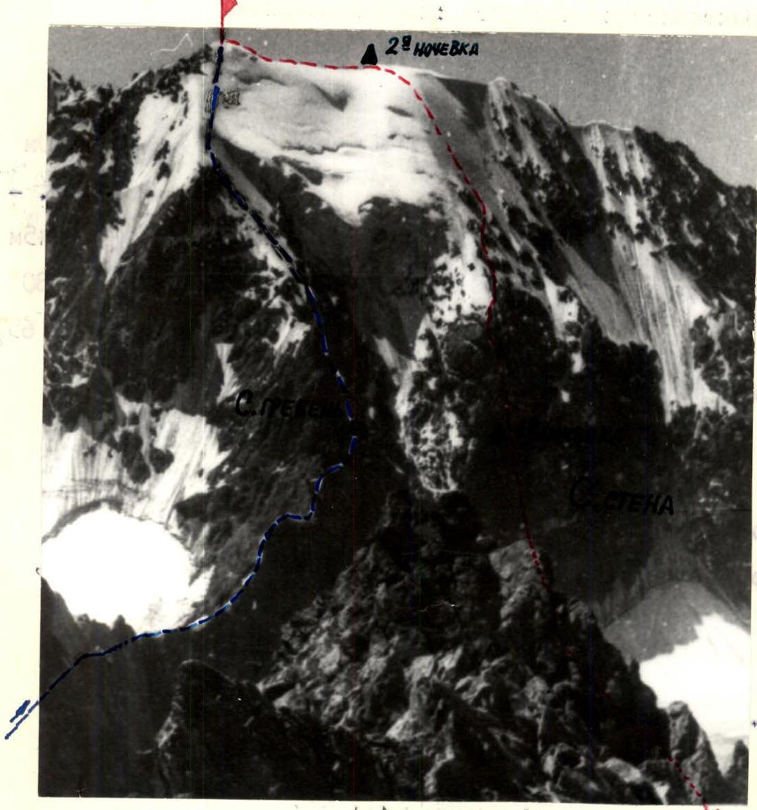
ROUTES TO KOLTSOVA PEAK FROM N:
- ——— VIA N RIDGE
- — — — VIA N WALL
Koltsova peak
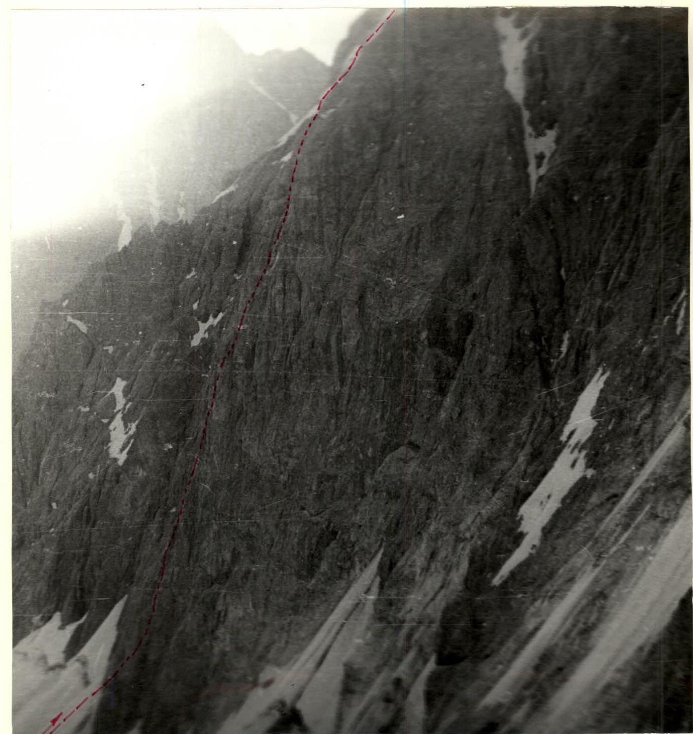
PROFILE OF THE LOWER PART OF THE ROUTE (taken from Aidarbek peak)

PROFILE OF THE UPPER PART OF THE ROUTE (taken from Aidarbek peak)
Route Sections Table
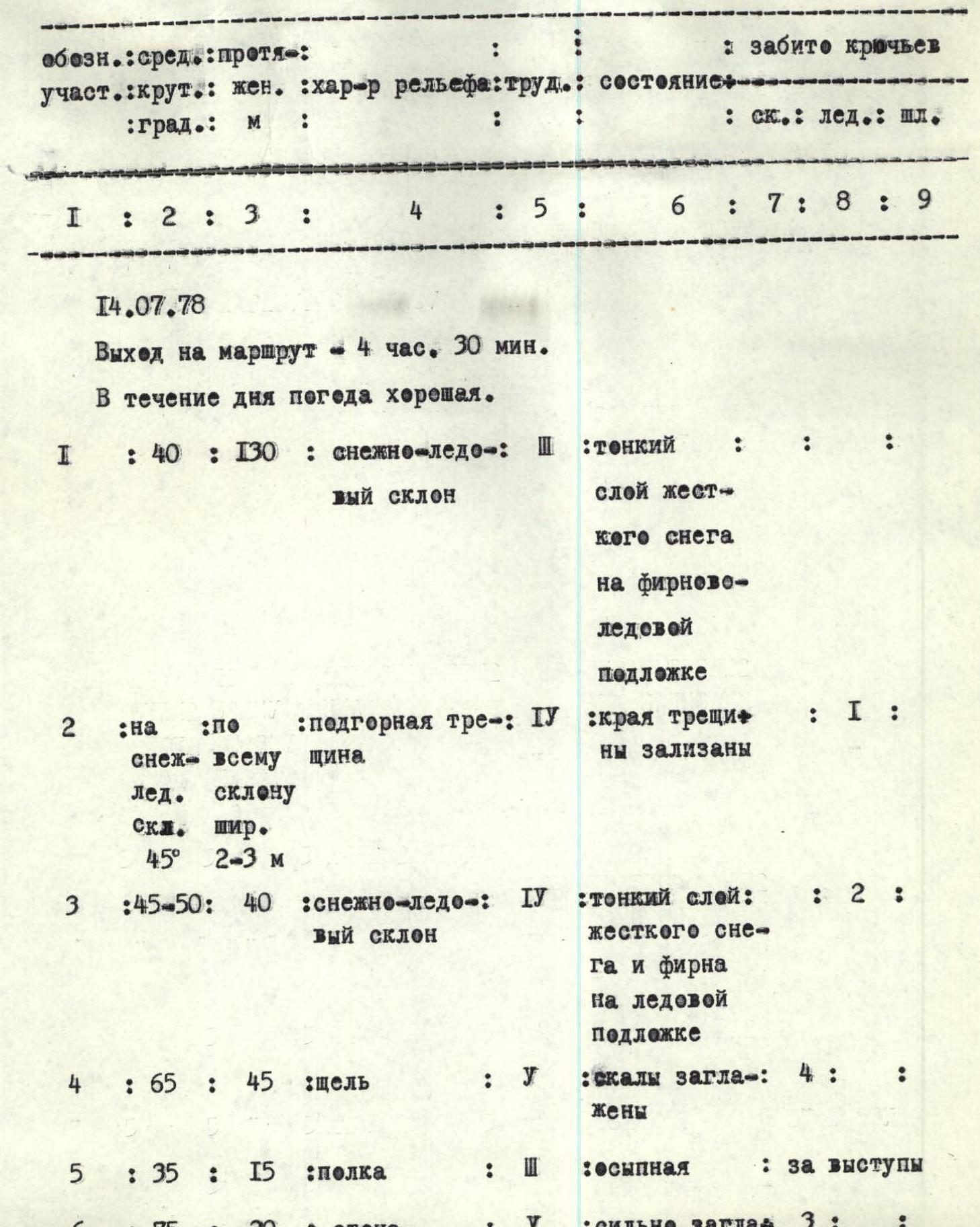
| Designation | Steepness (degrees) | Length (m) | Terrain characteristics | Difficulty category | Condition | Rock pitons driven | Ice pitons driven | Bolt pitons driven |
|---|---|---|---|---|---|---|---|---|
| July 14, 1978 | ||||||||
| Departure on the route - 4:30 AM. Weather is good throughout the day. | ||||||||
| R1 | 40 | 130 | snow-ice slope | 3 | thin layer of hard snow on firn-ice substrate | |||
| R2 | 45 | marginal crevasse, 2-3 m wide, across the entire slope | 4 | crevasse edges are smoothed | 1 | |||
| R3 | 45-50 | 40 | snow-ice slope | 4 | thin layer of hard snow and firn on ice substrate | 2 | ||
| R4 | 65 | 45 | crack | 5 | rocks are smoothed | 4 | ||
| R5 | 35 | 15 | ledge | 3 | talus | |||
| R6 | 75 | 20 | wall | 5 | heavily smoothed | 3 | ||
| R7 | 75-80 | 50 | inner corner | 5-6 | walls are heavily smoothed | 10 | ||
| R8 | 65 | 20 | wall | 6 | monolith | 4 | ||
| R9 | 30 | 10 | ledge | 4 | with areas of broken rocks | |||
| R10 | 75-80 | 15 | wall | 5-6 | monolith | 5 | ||
| R11 | 85 | 20 | wall with inner corner | 5-6 | inner corner walls are heavily smoothed | 8 | ||
| R12 | 75-80 | 45 | wall | 5-6 | very limited number of small holds and cracks | 6 | ||
| R13 | 80 | 25 | wall with oblique narrow inner corner | 5 | monolith | 2 | ||
| R14 | 88 | 10 | wall | 6 | monolithic, heavily smoothed | 1 | ||
| R15 | 10 | 2 m² | oblique ledge | |||||
| R16 | 60 | 10 | wall | 4 | monolith | 1 | ||
| R17 | 75 | 25 | inner corner | 5 | monolith | 3 | ||
| R18 | 10 | 2 m² | ledge | |||||
| Stop for the night - 18:40. Climbing hours - 14 hours 10 minutes. Bivouac is semi-sitting. To the right of the ledge, there is a large snow patch that can be used for cooking. | ||||||||
| July 15, 1978 | ||||||||
| Departure on the route - 6:00 AM. Weather is good throughout the day. | ||||||||
| R19 | 70 | 25 | chimney | 5-6 | monolith | 8 | ||
| R20 | 80 | 7-8 | small wall | 5 | monolith | 2 | ||
| R21 | overhanging | 4-5 | overhang | 5 | monolith | |||
| R22 | 70 | 20 | chimney | 4-5 | monolith | 2 | ||
| R23 | 70 | 20 | wall | 5 | monolith, rocks are smoothed | 1 | ||
| R24 | 85, with overhang | 50 | wide chimney with overhanging section 3-4 m | 5-6 | walls are heavily smoothed, covered with flow ice | 2 | ||
| R25 | 40 | 20 | rocks | 4-5 | smoothed, resembling "ram's foreheads" | 3 | ||
| R26 | 10 | 2 m × 2 m | balcony | |||||
| R27 | 55 | 40 | rocks | 4-5 | resembling "ram's foreheads", with water flows | 3 | ||
| R28 | 50 | 120 | rocky outcrops | 4 | smoothed, resembling "ram's foreheads" | 5 | ||
| R29 | 50-55 | 90 | ice slope with rock outcrops | 4-5 | ice, partially covered with a thin layer of firn, water flows in some areas, flow ice in some places | 2 | 3 | |
| R30 | 45-50 | 270 | ice slope | 4-5 | ice is partially covered with loose, "airy" snow | 18 | ||
| R31 | 5 | 10 m × 15 m | large area | |||||
| Stop for the night - 19:40. Climbing hours - 13 hours 40 minutes. Bivouac is lying down. | ||||||||
| July 16, 1978 | ||||||||
| Departure on the route - 9:20 AM. Weather is good throughout the day. | ||||||||
| R32 | 20 | 200 | ridge | 3 | towards the N wall covered with snow-firn fields, towards Kemisdykty valley - outcrops of broken rocks | |||
| Reached the summit at 11:00 AM. Climbing hours - 1 hour 40 minutes. Total climbing hours - 29.5 hours. |
Brief Explanation of the Route Sections Table
The route starts with a snow-ice slope (R1-R3), intersected by a marginal crevasse (R2). The marginal crevasse is 2-3 m wide. The crevasse is overcome by descending into it and ascending via an ice wall with a steepness of ~75° using crampons.
The wall part of the route begins with a crack (R4). The rocks have a strong smoothing and resemble "ram's foreheads".
Via a small ledge (R5), the team approaches the wall (R6). The wall rocks are also heavily smoothed and have very few holds.
The team ascends the wall to reach a large inner corner (R7) with smooth walls. Climbing is very difficult.
After the inner corner, there is a difficult monolithic wall (R8). The wall is almost smooth. It was overcome using ladders.
Via a ledge with broken rocks (R9), the team reaches a monolithic wall (R10) and a wall with an inner corner (R11). The wall rocks are heavily smoothed. Climbing is very difficult.
Then, the team reaches a large difficult wall (R12). The entire wall is practically monolithic, with a very limited number of small holds and cracks. Climbing is very difficult. The wall was passed with rope hauling.
A wall with an oblique narrow inner corner (R13) is traversed with a difficult traverse along the inner corner.
After a monolithic wall (R14), there is an oblique small ledge (R15). If necessary, a semi-sitting bivouac can be organized here.
After a monolithic wall (R16) and an inner corner (R17) with smoothed walls, another small ledge (R18) is encountered. Here, the team organized a semi-sitting bivouac. To the right of the ledge, there is a large snow patch that can be used for cooking.
A chimney (R19) is climbed with difficult climbing. After a small monolithic wall (R20), the team passes under an overhanging slab (R21) and reaches a chimney (R22).
Via a chimney resembling a crack, the team reaches a monolithic wall with smoothed rocks (R23) on the left.
Then, there is a large wide chimney (R24). The chimney walls are heavily smoothed. The rocks are covered with flow ice. Climbing is very difficult. In the upper part of the chimney, there is an overhanging section 3-4 m long. The chimney was passed with rope hauling.
Via smoothed rocks (R25) resembling "ram's foreheads", the team reaches a balcony (R26). If necessary, a tent can be set up on the balcony.
The last section of the N wall consists of rocks resembling "ram's foreheads" with water flows (R27).
The N wall of Koltsova peak has a length of 490 m. Sections with V-VI difficulty category on the wall constitute 420 m (610 m on the entire route). The first climber traversed the entire wall in galoshes. The rest climbed in "vibram" boots.
After the wall, there are rocky outcrops (R28) resembling "ram's foreheads", with smoothed rocks. The rocky outcrops are partially covered with flow ice, snow, and firn. In some areas, water flows across the rocky outcrops.
After the rocky outcrops, the team reaches an ice slope with rock outcrops (R29). The ice slope is partially covered with:
- a thin layer of snow,
- firn,
- flow ice.
The team moves mainly along the rock ridges to the right of them.
The ice slope (R30) is partially covered with very loose, literally "airy" snow. On sections R29-R30, the first climber wore crampons.
After the ice slope, the team reaches a large area on the ridge (R31). The area is a small talus with individual rock outcrops. It is very convenient for a bivouac. The team had their second bivouac here.
The ascent to the summit is via a long ridge (R32):
- Towards the N wall, the ridge is covered with powerful snow-firn fields.
- Towards the Kemisdykty valley, the ridge consists of outcrops of broken rocks.
- The summit is reached via broken rocks, partially on snow.
Descent from Koltsova Peak
The descent from Koltsova peak is to the south, towards the Kemisdykty valley. The descent begins from the ridge, returning 80-100 m from the summit.
The descent goes via:
- broken rocks,
- talus ledges,
- couloirs.
In some places, "ram's foreheads" and small walls are encountered. One 20 m sport rappel was made.
Then, the descent continues via a wide talus couloir covered with snow. The couloir leads to a lake on the Kemisdykty glacier. The descent takes ~1 hour.
Then, the team descends along the glacier for ~1 hour. Further, they move down via moraine and talus slopes for ~2 hours. The total descent from the summit and exit to the Kok-Su river takes 4 hours. From here, the team returns to the bivouac under the N wall. From the bivouac, they exit to the Kok-Su river.
Along the Kok-Su river valley, the team returns to the base camp. The descent from the bivouac under the N wall to the base camp on the Kok-deba meadow takes 8-10 hours.