Ascent Log
- Ascent classification: technical
- Ascent area: Pamir-Alay, Alay Ridge
- Peak, its height, route: p. Shait, 4916 m, ascent via the NE wall: via Moiseevtsev's path (officially recognized)
- Expected difficulty category: 5B
- Route characteristics: height difference 900 m, average steepness 65°; section lengths: 4th diff. cat. — 535 m, 5th diff. cat. — 560 m, 6th diff. cat. — 65 m.
- Pitons driven: for belaying: rock — 47, ice — 8, protection — 33; for creating belay stations: rock — 1, ice — 1, protection — 5.
- Number of climbing hours: 12
- Number of bivouacs and their characteristics: no bivouacs
- Surname, initials of leader, participants, their sports qualification: Shumikhin Gennadiy Ivanovich — Candidate for Master of Sports, Svitov Anatoliy Mikhaylovich — Candidate for Master of Sports.
- Team coach: Yakovlev Vitaliy Dmitrievich — senior instructor, Master of Sports of the USSR.
- Date of departure for the route and return: departure — July 17, 1979 at 3:30 AM, return — July 17, 1979 at 3:30 PM.
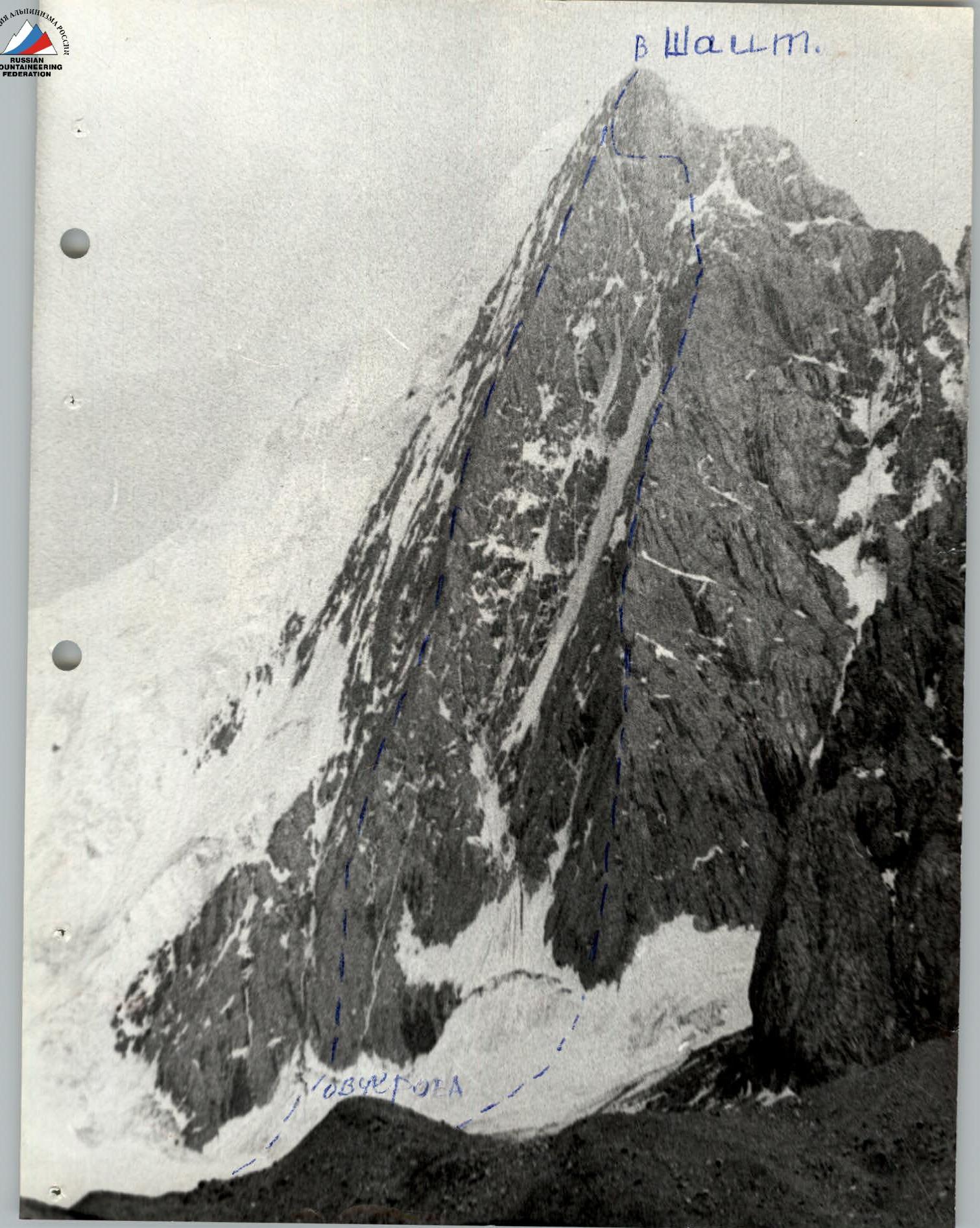
TABLE OF MAIN ROUTE CHARACTERISTICS
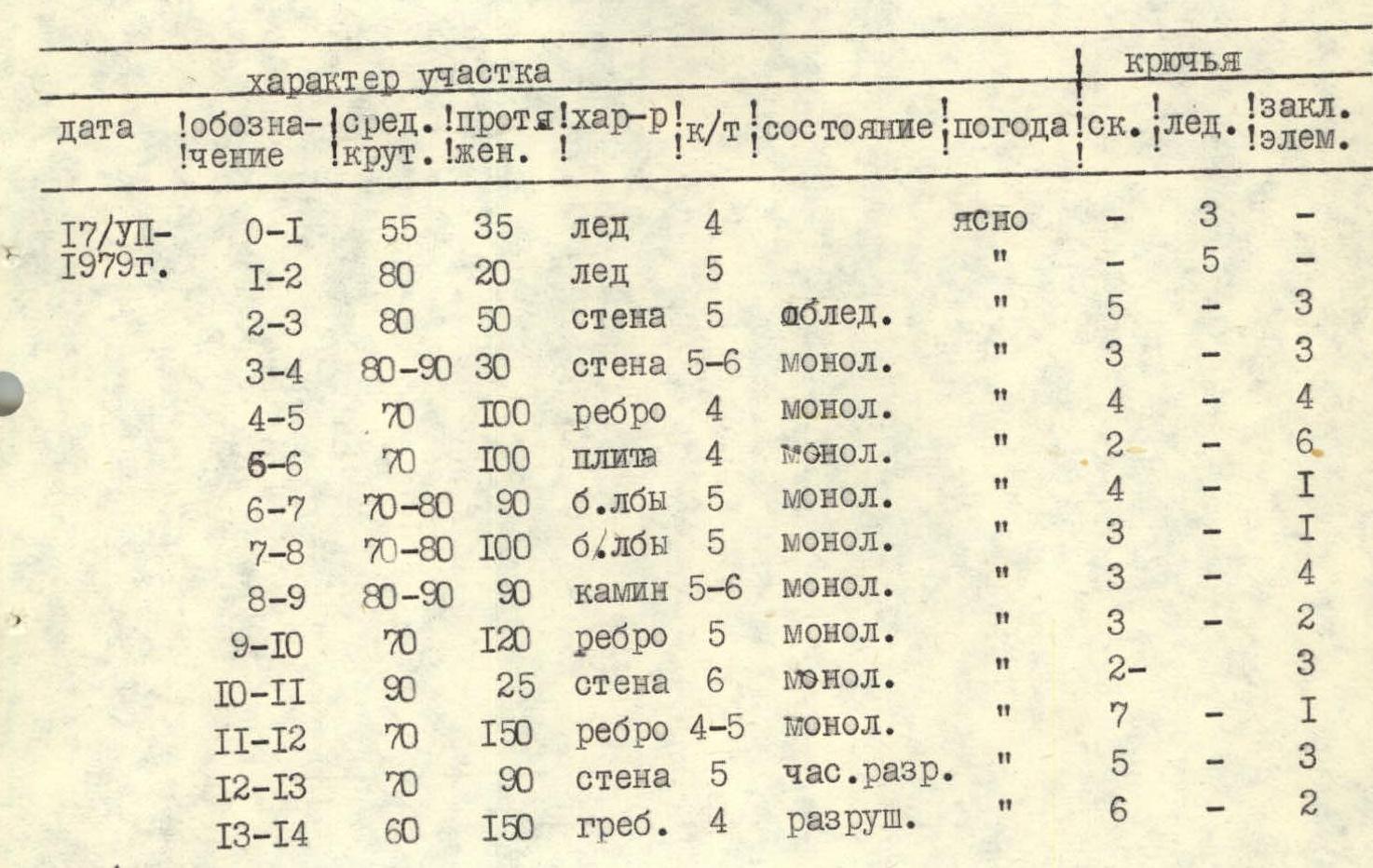
| Date | Designation | Avg. steepness | Length | Character | Diff. cat. | Condition | Weather | Rock pitons | Ice pitons | Protection pitons |
|---|---|---|---|---|---|---|---|---|---|---|
| July 17, 1979 | R0–R1 | 55 | 35 | ice | 4 | Clear | – | 3 | – | |
| R1–R2 | 80 | 20 | ice | 5 | » | – | 5 | – | ||
| R2–R3 | 80 | 50 | wall | 5 | icy | » | 5 | – | 3 | |
| R3–R4 | 80–90 | 30 | wall | 5–6 | monolithic | » | 3 | – | 3 | |
| R4–R5 | 70 | 100 | ridge | 4 | monolithic | » | 4 | – | 4 | |
| R6–R6 | 70 | 100 | slab | 4 | monolithic | » | 2 | – | 6 | |
| R6–R7 | 70–80 | 90 | glaciated rock | 5 | monolithic | » | 4 | – | 1 | |
| R7–R8 | 70–80 | 100 | glaciated rock | 5 | monolithic | » | 3 | – | 1 | |
| R8–R9 | 80–90 | 90 | chimney | 5–6 | monolithic | » | 3 | – | 4 | |
| R9–R10 | 70 | 120 | ridge | 5 | monolithic | » | 3 | – | 2 | |
| R10–R11 | 90 | 25 | wall | 6 | monolithic | » | 2 | – | 3 | |
| R11–R12 | 70 | 150 | ridge | 4–5 | monolithic | » | 7 | – | 1 | |
| R12–R13 | 70 | 90 | wall | 5 | partially destroyed | » | 5 | – | 3 | |
| R13–R14 | 60 | 150 | ridge | 4 | destroyed | » | 6 | – | 2 | |
| July 17, 1979 |
Brief explanation of the table
- R0–R1 — Ice, piton belay.
- R1–R2 — Bergschrund about 3 m with an overhang, leading to an ice wall.
- R2–R3 — Icy wall, destroyed rocks with frozen stones.
- R3–R4 — Before reaching the ridge — complex climbing, protection.
- R4–R5 — Clear ridge, few crevices.
- R5–R6 — Upper part of the slab forms a ridge, wide crevices.
- R6–R8 — Glaciated rock, few crevices, friction climbing.
- R8–R9 — Chimney 1–2 m wide, climbed in a stem.
- R9–R10 — Smooth rocks, few crevices.
- R10–R11 — To the right of the ridge, a wall with wide crevices, good placement for "gecko"-type protection.
- R11–R12 — Clearly defined ridge.
- R12–R13 — Wall, slabs, sufficient crevices for pitons.
- R13–R14 — Common section with Mogilevtsev's route. Loose slabs, partially destroyed section.