- Class of technically challenging ascents.
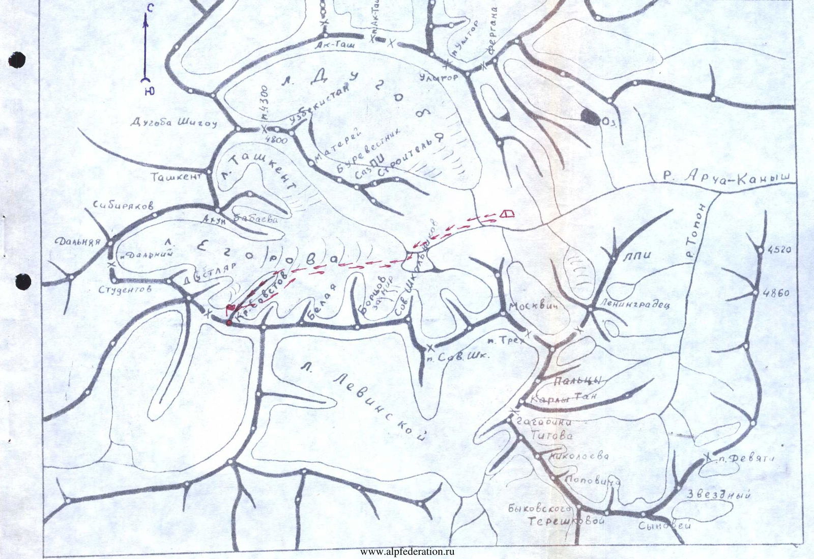
- Pamir-Alay. Alay Ridge. Archa-Kanysh Gorge.
- Krylya-Sovetov Peak (4900 m), via the north-eastern edge.
- Estimated difficulty category – 4B.
- Route characteristics:
a) elevation gain – 800 m;
b) length of sections with 4B-5B category difficulty: 280 m;
c) average steepness:
- ascent to the ridge 60°;
- pre-summit tower 55°.
- Pitons hammered for belaying: rock – 69; ice – 5; bolt – 0. Total – 74.
- Number of climbing hours – 17.
- One overnight stay on a good platform before the summit ascent.
- Climbing team leader – Rybalko K.P., 1st class alpinism, 1st class rock climbing. Team members: Protsenko L.V., CMS in alpinism and rock climbing, instructor; Petrichenko N.N., CMS in alpinism and rock climbing, instructor; Kozinny V.K., 1st class alpinism and rock climbing, instructor.
- Team coach – Master of Sports, senior instructor Saprykin V.D.
- Date of departure on the route – July 24, 1977, return from the route – July 25, 1977.
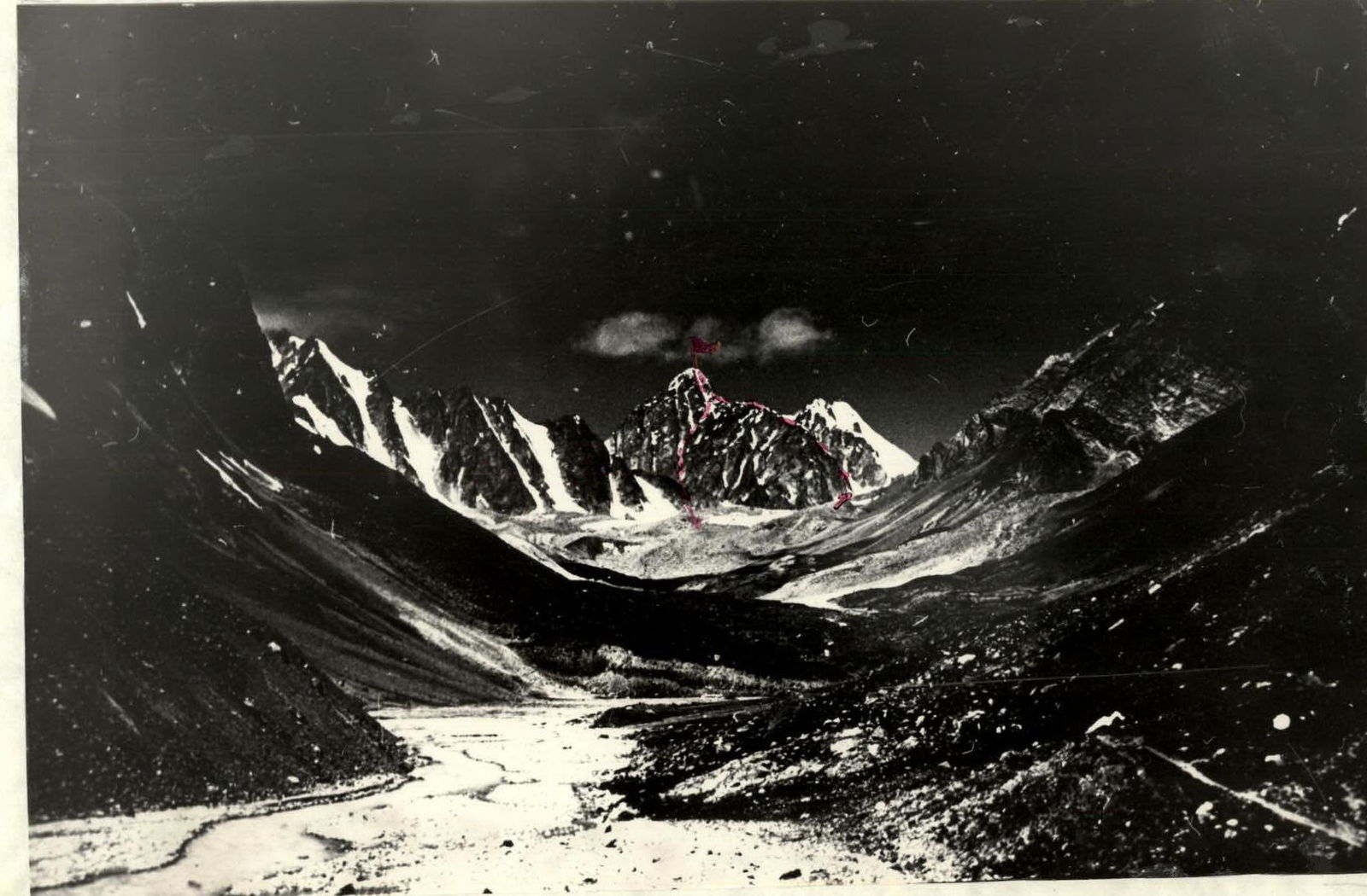 Mt. Krylya Sovetov (4900 m)
 Photograph taken from the confluence of the Dugoba and Archa-Kanysh rivers.
North-eastern wall leading to the ridge of Mt. Krylya Sovetov (4900 m)

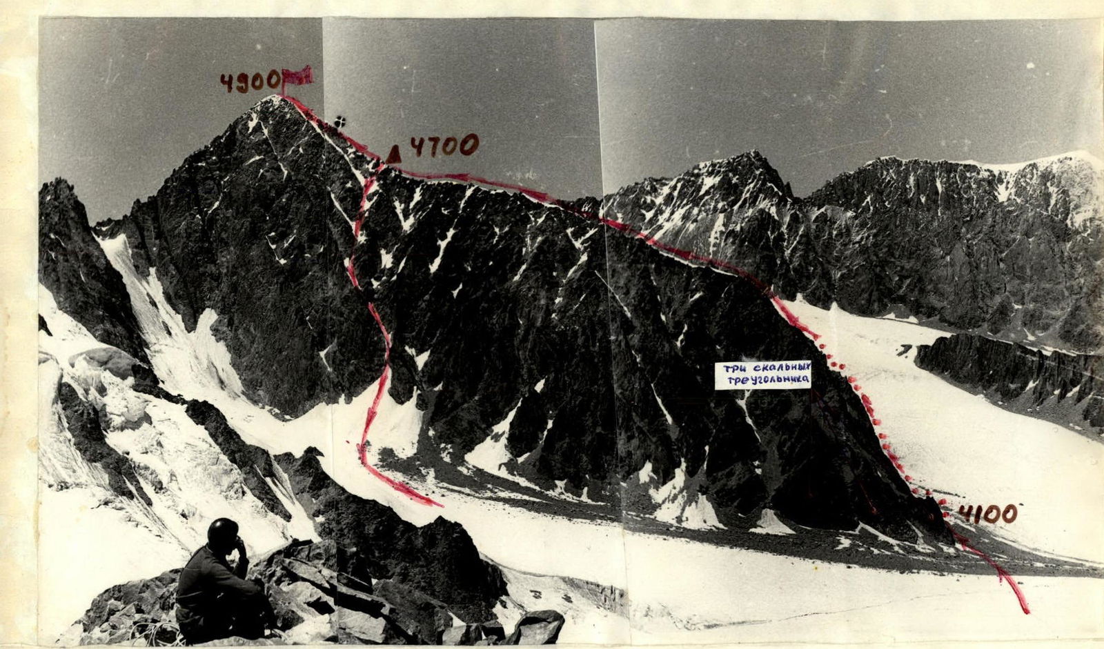
Part of the route profile along the north-eastern edge of Mt. Krylya Sovetov (photograph taken during the ascent of Mt. Belaya).
Route Description
From the "Archa-Kanysh" overnight stay at the confluence of the Dugoba and Archa-Kanysh rivers, we cross the Dugoba River and then move along the left bank of the Archa-Kanysh River towards Mt. Krylya Sovetov until we reach the Egorov Glacier. The lower part of the glacier is divided by a medial moraine. We approach the slope of the north-eastern edge along the moraine. The moraine narrows and splits, as if embracing the north-eastern edge. It takes 4 hours to reach the north-eastern edge from the overnight stay.
We exit to the route via the right branch of the moraine and then onto a talus cone located to the right of three rock triangles.
The route is divided into seven sections:
Section R0–R1 is a grey wall with a block structure. The talus cone we ascended to approach the route abuts into this wall. We ascend 40 m up the wall with piton belays to a 30-meter inclined terrace covered with fine gravel and sand. When moving along the wall, it is necessary to exercise extreme caution due to numerous "live" stones. We wait until all participants complete this section and then traverse the terrace upwards to the right, under the red rocks located 40 m to the right of a huge overhanging red stone.
Section R1–R2 is a smooth monolithic wall cut by a long crack. The wall's steepness is 75–80°. Movement is carried out along the crack up to the second talus shelf. The first climber ascends in caligas, without a backpack, with piton belays, and the climbing is challenging. During the ascent, it is necessary to wedge feet into the crack. The remaining participants ascend via the rope fixed by the first climber. For safety, we wait again until all participants gather on the shelf, as further movement requires traversing the shelf, which contains an abundance of loose stones.
Section R2–R3. We move 30 m along the shelf to the left, towards a steep grey couloir. However, the presence of "live" stones on the slab and the impossibility of organizing quality belays force us to traverse this section via the grey couloir. The shelves and holds in the couloir are smooth. The rocks resemble "sheep's foreheads." Pitons, however, "fit" perfectly. Climbing is difficult. We ascend 60 m up the couloir to a rock island in an "amphitheater." Movement is done one by one. The first participants to reach the rock island must be extremely cautious, as the "amphitheater" is filled with gravel. Belaying of lower participants can be organized through pitons hammered into the rock island. From the rock island, we move 4.5 m to the right and upwards to a vaguely defined edge. Movement is across grey blocks. Belays are via pitons. During climbing, the hands are heavily loaded because the participant is "pushed away" from the rock due to the accumulation of blocks.
Section R3–R4 begins with a large internal corner, up the right part of which we ascend to a wall. The internal corner contains numerous shelves. Movement is along the right side of the internal corner. Further movement is across rocks of medium difficulty. The logical path is along the wall in the direction of a snow cap on the ridge (100 m). Belays are alternating. It is possible to move in independent teams. Not reaching the snow cap, the wall unexpectedly becomes steeper, so we have to move along a narrow chimney. By wedging legs and arms in the chimney, the first climber overcomes part of the chimney and secures the rope. After all participants ascend to the belay point, the first climber continues moving up the chimney. During movement through the chimney, special concentration is required, as all stones dislodged by participants fall down the chimney. The chimney leads to a more gentle ridge. It takes 6 climbing hours to reach the ridge from the start of the route.
Section R4–R5. We move 400 m along the ridge to a control cairn. The ridge is narrow, with a mix of rock, snow, and ice, and numerous "gendarmeries." To the northwest, the ridge drops away with a steep 70° ice slope, and to the southeast, it drops away with severely destroyed walls and couloirs. Movement along the ridge is alternating and simultaneous, with belays through outcrops. Movement is along the boundary of rock, snow, and ice. Some "gendarmeries" are overcome head-on. There are smooth vertical walls up to 3–4 m, which are quickly overcome by having the first participant boosted up by team members standing on their shoulders. The control cairn is located under a large "gendarmerie" called "golova" (head).
Section R5–R6. After the control cairn, there is a slight depression in the ridge. We move simultaneously across snow for about 100 m. We approach a huge black "gendarmerie" intersected by grey bands. The "gendarmerie" is overcome head-on (70 m). Climbing is of medium difficulty but tense due to the abundance of ice. Belays are via pitons. From the "gendarmerie," we move simultaneously towards the pre-summit ascent, throwing the rope over outcrops. Before the ascent, there is a good platform for setting up a tent. There is snow near the platform.
Section R6–R7. From the bivouac site, we move along the ridge to a large grey "gendarmerie." The "gendarmerie" can be bypassed either from the left or the right:
- To the right, the "gendarmerie" is bypassed via a narrow crevice (20 m). Climbing is difficult. Hands move along the crevice using friction for the feet as a point of support.
- To the left, after cutting a snow cornice, the "gendarmerie" is bypassed via a narrow shelf overhung by huge blocks. The blocks hinder normal movement along the shelf, pushing participants away from the rock. Movement along the shelf is done without backpacks. Backpacks are pulled up.
Section R7–R8 — the pre-summit ascent has an average steepness of 55°. The ascent is primarily snow and ice with 10–15-meter rock walls with a steepness of 80–90°. Climbing is difficult and, in places, very difficult, across rocks with ice accretion. Belays are via pitons. Climbing is combined with cutting steps in the ice accretion. Two walls are particularly challenging for climbing. The first, reddish wall is traversed along its right part. The second, grey wall is overcome centrally. During movement, it is necessary to knock off ice accretion and clear holds and footholds. The exit to the summit is via a 45° ice slope (35 m). The first climber ascends on the front points of their crampons, the rest via a fixed rope.
It takes 17 climbing hours from the start of the route to the summit. The descent from the summit follows the ascent route down to the start of the summit ascent. Further descent is to the southeast via couloirs, narrow chimneys, and destroyed rocks onto the Egorov Glacier. During the descent, four "doulfers" were set up.
The technical characteristics of the route are presented in Table 1. The team's equipment is listed in Table 2.
TABLE №1
TECHNICAL CHARACTERISTICS TABLE OF THE ROUTE along the north-eastern edge of MT. KRYLYA-SOVETOV (4900 m) – ARCHA-KANYSH GORGE, ALAY RIDGE, FIRST ASCENT
| № | Designation of section, date | Steepness in degrees | Length in meters | Nature of relief | Difficulty | Condition | Weather | Belaying (piton hits) | Passage (piton traversed) | Time of exit and stop for bivouac, climbing hours | Bivouac conditions |
|---|---|---|---|---|---|---|---|---|---|---|---|
| 1 | R0–R1 | Rock | Ice | Bolt | Rock | ||||||
| a) across the grey wall | 55°–60° | 40 | rock wall | 4B | "live stones on shelves" | excellent | 3+2 | free climbing | Exit to the route at 8:00 | ||
| b) across the terrace | 15°–20° | 20 | inclined terrace | 1 | "freely hanging stones" | 2 (belay points) | free climbing | Stop for bivouac at 16:30 | |||
| 2 | R1–R2 | 75°–80° | 20 | crack | 5A | monolith with small holds | 1 | 4+2 | free climbing, fixed rope, pulling up the first participant's backpack | On the first day, 11 climbing hours | |
| 3 | R2–R3 | ||||||||||
| a) across the shelf | 10° | 30 | narrow shelf | 1 | "live stones on the shelf" | 1 | via outcrops | free climbing | |||
| b) across the vertical couloir | 70° | 60 | couloir | 4B | "sheep's foreheads" | 1 | 5+2 | free climbing | |||
| c) across grey blocks | 65° | 45 | system of overhanging blocks | 4B | blocks with large cracks | 1 | 3+2 | free climbing | |||
| 4 | R3–R4 | ||||||||||
| a) internal corner | 50° | 60 | plane of a large internal corner | 3A | monolithic internal corner | 1 | 3+2 | free climbing | |||
| b) wall | 45° | 100 | wall with many holds | 3A | partially destroyed wall | 1 | 3+ belay point via outcrops | free climbing | |||
| c) chimney | 55° | 60 | narrow chimney | 4A | jammed | 1 | 4+2 | free climbing | |||
| 5 | R4–R5 | 30° | 400 | ridge with "gendarmeries," walls, snow, ice | 2B | destroyed | 1 | via outcrops | free climbing | ||
| 6 | R5–R6 | ||||||||||
| a) along the ridge | 5°–10° | 100 | snow, ice | 1 | // | via ice axe | free climbing | ||||
| b) across the black "gendarmerie" | 55°–60° | 40 | rock wall | 4B | rock wall with ice accretion | // | 4 + belay points via outcrops | free climbing | |||
| BIVOUAC | securing the tent and participants on the bivouac via 3 rock pitons and outcrops | bivouac on a good snow platform | |||||||||
| 7 | R6–R7 (July 25, 1977) | 30° | 20 | oblique crevice | 3B | monolith | light cloudiness | 2+ | belay via outcrops | free climbing, fixed rope, pulling up backpacks | Exit to the route at 7:00 |
| 8 | R7–R8 | ||||||||||
| a) across the yellow wall | 80°–90° | 25 | vertical wall | 5B | monolith with ice accretion | 1 | 3+2 | free climbing, fixed rope | On the summit at 6:30 | ||
| b) across the ice and snow slope | 55° | 60 | ice partially covered with snow | 4A | hard ice | 1 | 3 ice screws | first participant on front points of crampons, fixed rope | |||
| c) across the grey wall | 80° | 20 | vertical wall | 5A | monolith with ice accretion | 1 | 4+2 | free climbing, fixed rope | |||
| d) across the ice slope | 45° | 35 | ice slope | 3B | hard ice | 1 | 2 ice screws | first participant on front points of crampons, fixed rope | |||
| Total | 69 | 5 ice screws | Total climbing hours to the summit 17 | ||||||||
| Descent from the summit | – | Descent from the summit to the Egorov Glacier 5 hours | |||||||||
| Total climbing hours | Total climbing hours including descent 22:00 |


