
Ascent Passport
- Ascent class — technical.
- Ascent region — Tian Shan, Chatkal Ridge.
- Ascent route — to the summit of Big Chimgan via the north-eastern wall. Summit elevation — 3207 m above sea level.
- Ascent characteristics:
- elevation gain — 2000 m;
- average steepness — 62°;
- complex section length — 700 m.
- Pitons hammered in:
- rock — 35
- ice —
- bolted —.
- Total climbing hours — 20.
- Number of bivouacs and their characteristics — one bivouac on a good site near the summit ridge.
- Team name — CS DSO "Mehnat".
- Surname, initials of the leader, team members and their qualification:
Group I
- Galkin S.P. — 1st sports category
- Berezhnaya L.A. — CMS
- Popov G.Ya. — 1st sports category
- Tsoy V. — 1st sports category Group II
- Ivanov E.P. — 1st sports category
- Zainutdinov G.S. — 1st sports category
- Korovkin O.A. — CMS
- Korolev M. — CMS
- Pertciger F.I. — 1st sports category
- Shugaev S. — CMS
- Team coach — Tysyachnaya G.G.
II. Dates of departure and return — - Group I — April 30, 1977 — May 1, 1977 - Group II — May 2, 1978 — May 3, 1978
Route Description
Ascent to the summit of Big Chimgan via the north-eastern wall. Big Chimgan, 3207 m above sea level, is located in the Chatkal Ridge of Tian Shan. The area is inhabited and well-developed. Traditional alpinades take place here in late April and early May. By this time, a snowy winter gives way to a capricious spring with abundant precipitation. By the end of April, the lower boundary of snowfields is at an elevation of 1400–1600 m, and the summit is entirely covered with snow, often avalanche-prone.
The route starts from the base camp in the "12 springs" tract. After passing through Pesochny pass, we enter the Gulikamsay valley. Descend to the first confluence, then turn right and head upwards towards the NE wall, initially following a stream and then a snowfield. The route is clearly visible when descending from the pass.
Section R0–R1: ascend a snowy couloir, bypassing a steep rocky drop with black spots at the bottom on the right. Movement is on snow, 400 m, 30°. The couloir narrows and turns left — 250 m, 45°, simultaneous movement on dense snow. Exit via a steep talus couloir to the left, under the beginning of the wall section of the route, to control cairn No.1 (80 m, 50°).
Section R2–R3: move from the cairn along the wall, 60 m, 75°, with lower sections featuring talus shelves. Climbing is moderately difficult, with protection on ledges.
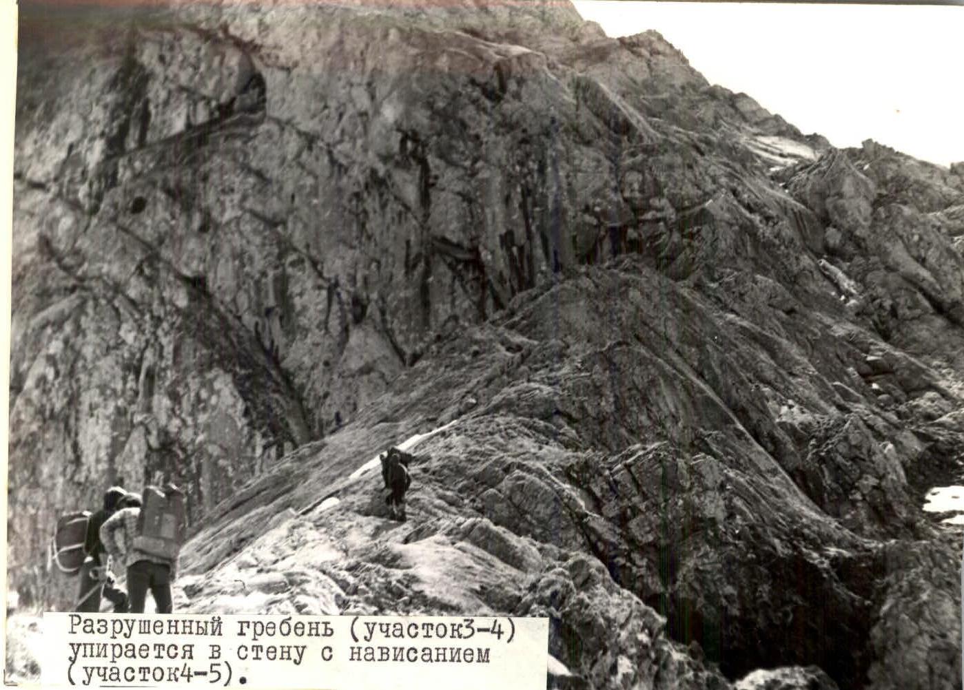
Section R3–R4: continue along a sharp, degraded ridge, 120 m, 45°, under a grey wall with white spots and an overhang. Movement along the ridge is simultaneous, with protection on ledges.
Section R4–R5 — key location. Ascend the wall with artificial aids and then traverse right. Climbing is very difficult, 40 m, 80°. Protection is with pitons (9 pieces). Lower sections feature wedges, upper sections feature petal-shaped pitons. The monolith is smooth and requires friction climbing. No bypass is available. Rope pulling for rucksacks is possible.
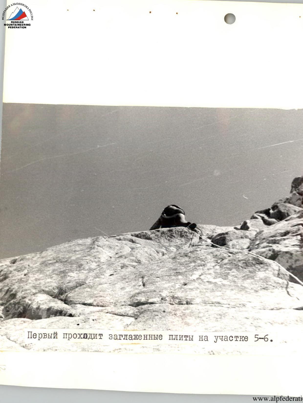
Section R5–R6: continue up the wall, 40 m, 70°, with difficult climbing and piton protection (5 pieces). The monolith has few cracks.
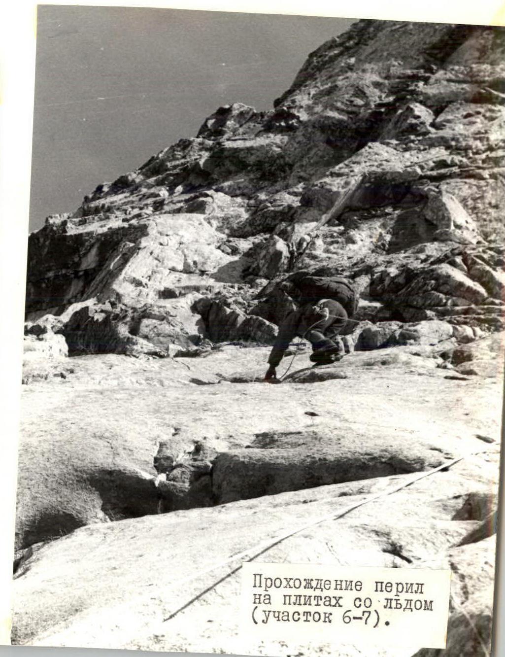
Section R6–R7: exit onto a wall composed of "ram's foreheads" with cracks filled with ice. Move along the wall from right to left, 60 m, 60°, as quickly as possible due to rockfall hazard. Piton protection — 5 pieces.
Section R7–R8: continue 40 m, 45° left and upwards to the start of an internal corner inclined from right to left. Piton protection — 3 pieces.
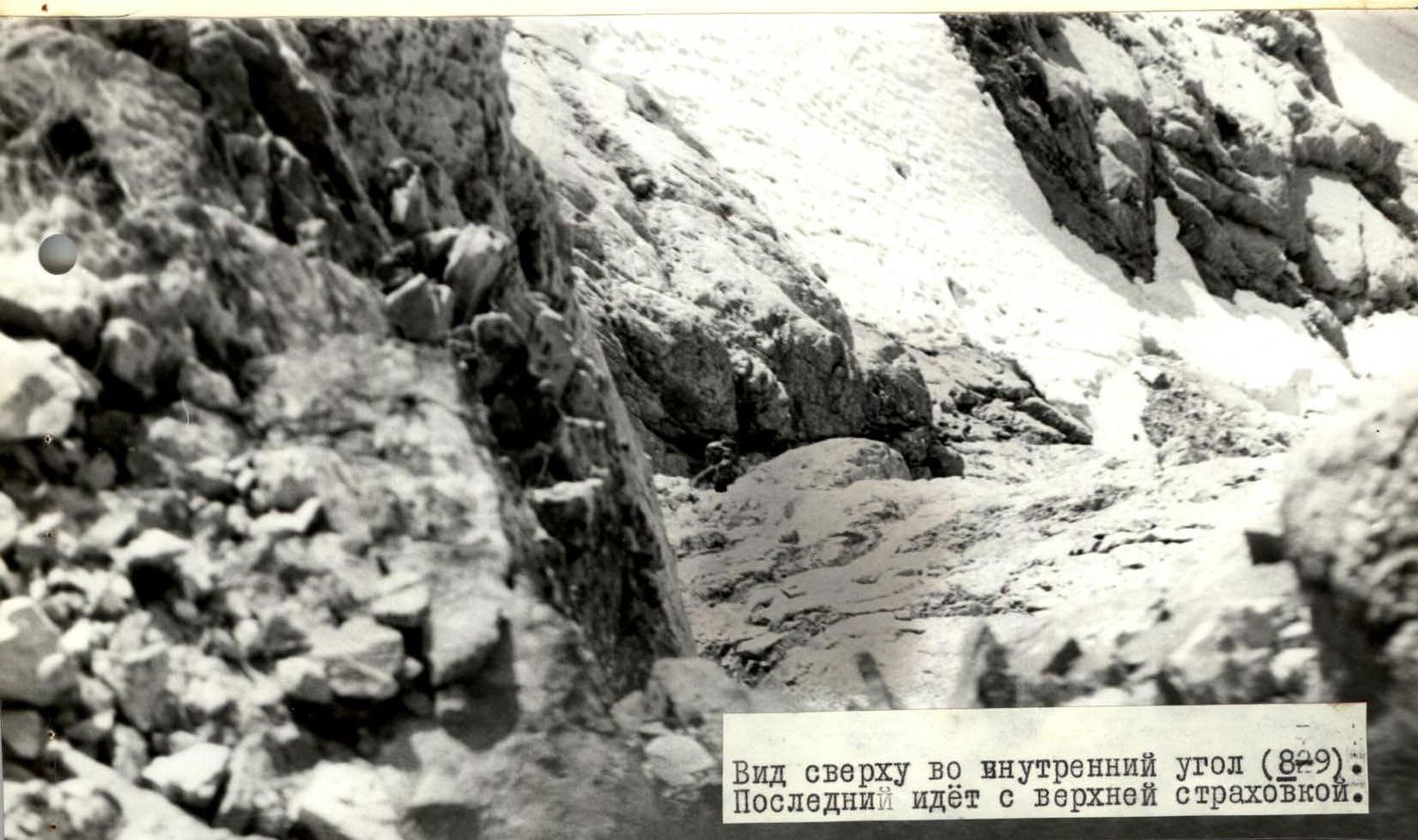
Section R8–R9: the lower part of the corner is filled with ice. Ascend the corner, 50 m, 70°. Many loose rocks. The overhang in the upper part is bypassed on the left. Piton protection — 6 pieces.
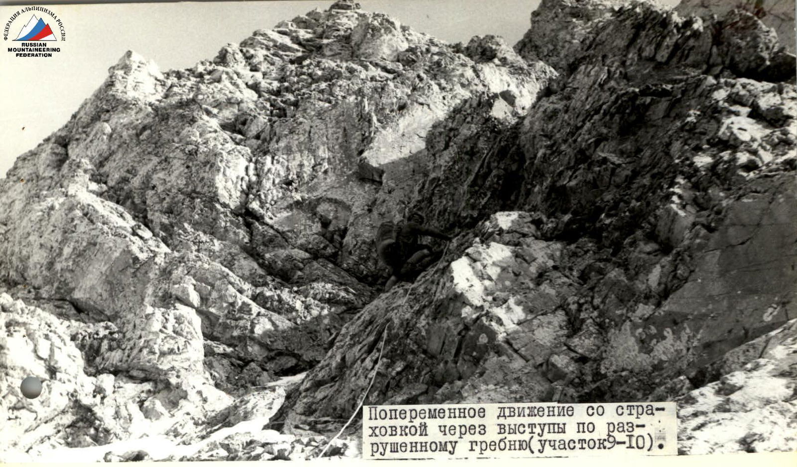
Section R9–R10: ascend a degraded ridge with three oblique talus shelves — upwards and right towards a snow-filled couloir. Alternate protection through ledges, 120 m, 50°.
Section R10–R11: in the lower part of the couloir, 20 m, 85°, ice climbing is difficult, with many loose rocks. Only two climbers can be accommodated at the belay stance. Piton protection — 5 pieces.
Section R11–R12: the couloir becomes less steep, 70 m, 70°. Climbing is complicated by loose rocks. Upper sections feature significant snow. Piton protection — 6 pieces. After the couloir, there is cairn No.2. The wall section of the route is completed. The wall is logical, with no bypasses on the right or left. In some years, there may be no ice on the rocks.
Section R12–R13: ascend a talus ridge, 300 m, 45°, to a degraded rocky ridge with numerous small pinnacles. Simultaneous movement.
Section R13–R14: move along the ridge, 400 m, 30°, bypassing pinnacles and reaching a good site. Bivouac.
Section R14–R15: depart at 5 am, have breakfast, and continue on the route. Ascend a talus slope, 160 m, 45°, to the summit ridge. Simultaneous movement.
Section R15–R16: the summit ridge is covered with a thick layer of snow, except for steep pinnacles. Ascend the ridge, 120 m, 30°, with snow providing good footing, simultaneous movement. To the right, the Central Ridge exit is visible, category 2B difficulty.
Section R16–R17: move along a gentle snowfield, 400 m, 20°, simultaneously along a sharp rocky ridge.
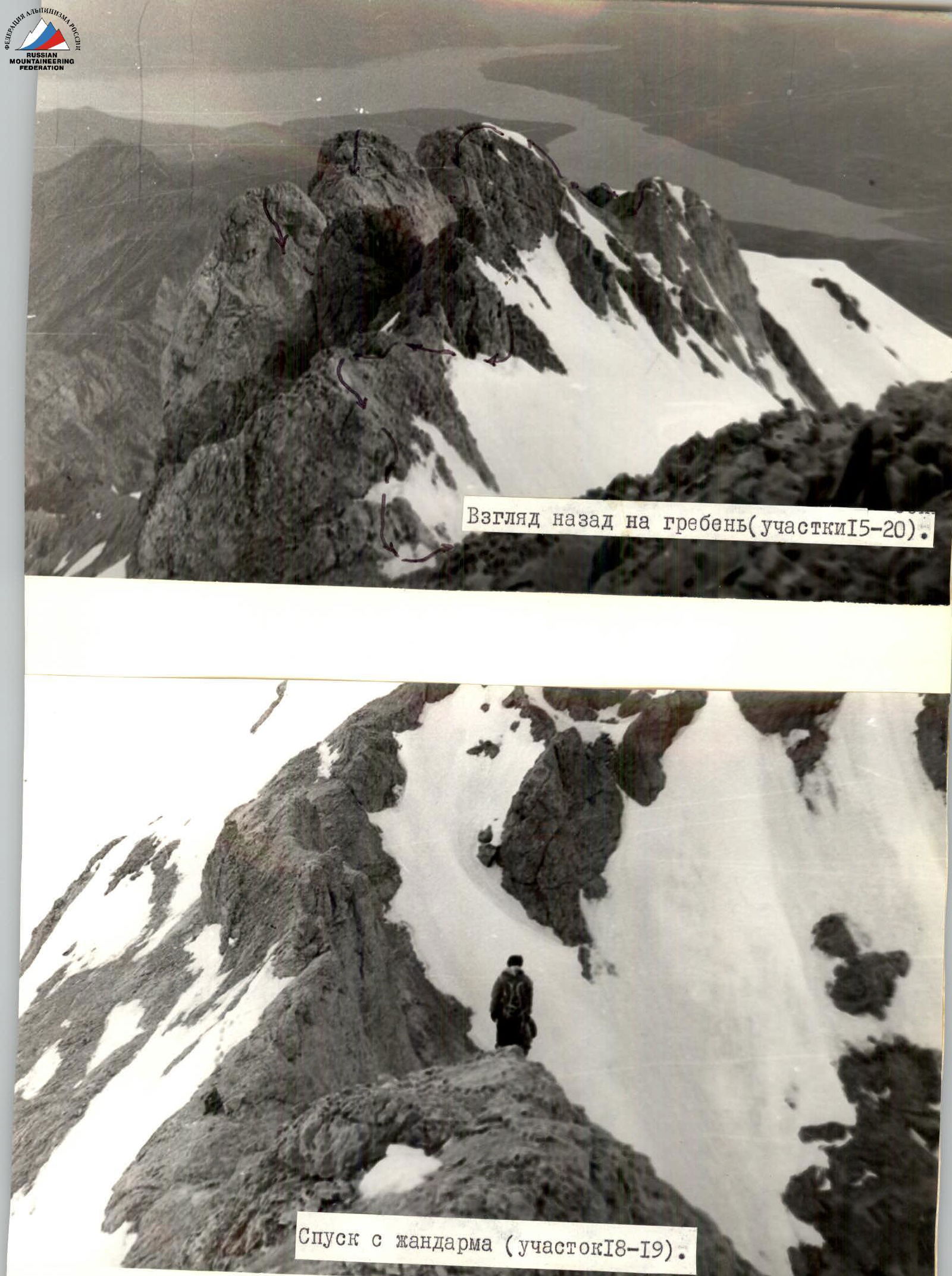
Section R17–R18: ascend a rocky pinnacle, 80 m, 45°. Snow near the rocks is loose and provides poor footing. Protection is through ledges.
Section R18–R19: descend 40 m, 35° with alternate protection through ledges.
Section R19–R20: ascend a rocky rise simultaneously, 60 m, 40°. Snow is present in gullies.
Section R20–R21: move along a gentle snowy slope, 500 m, 15°, simultaneously.
Section R21–R22: descend steep rocks, 50 m, 50°, with alternate protection through ledges.
Section R22–R23: ascend a rocky rise with snow, 160 m, 45°, with alternate protection through an ice axe.
Section R23–R24: move along a gentle snowy slope, 400 m, 15°, and reach the summit, cairn No.3.
Descend via the western ridge, following the category 1B route. The route took 30 hours. 35 rock pitons were hammered in. Total climbing hours — 20.
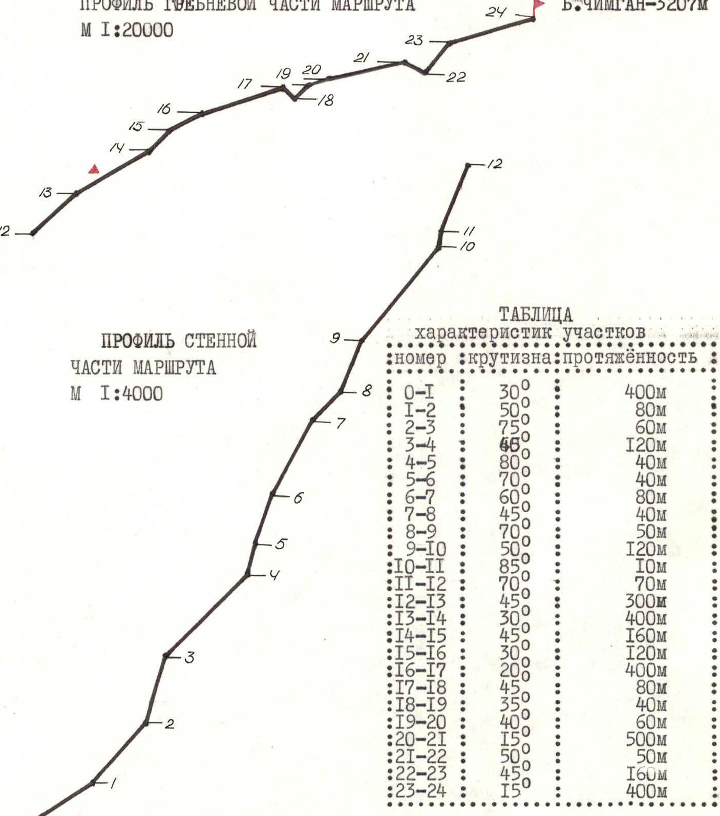
TABLE OF MAIN CHARACTERISTICS OF THE ASCENT ROUTE to Big Chimgan summit via the north-eastern wall, category 4A (approximate)
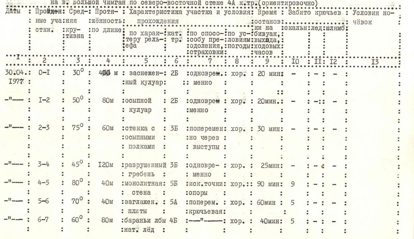
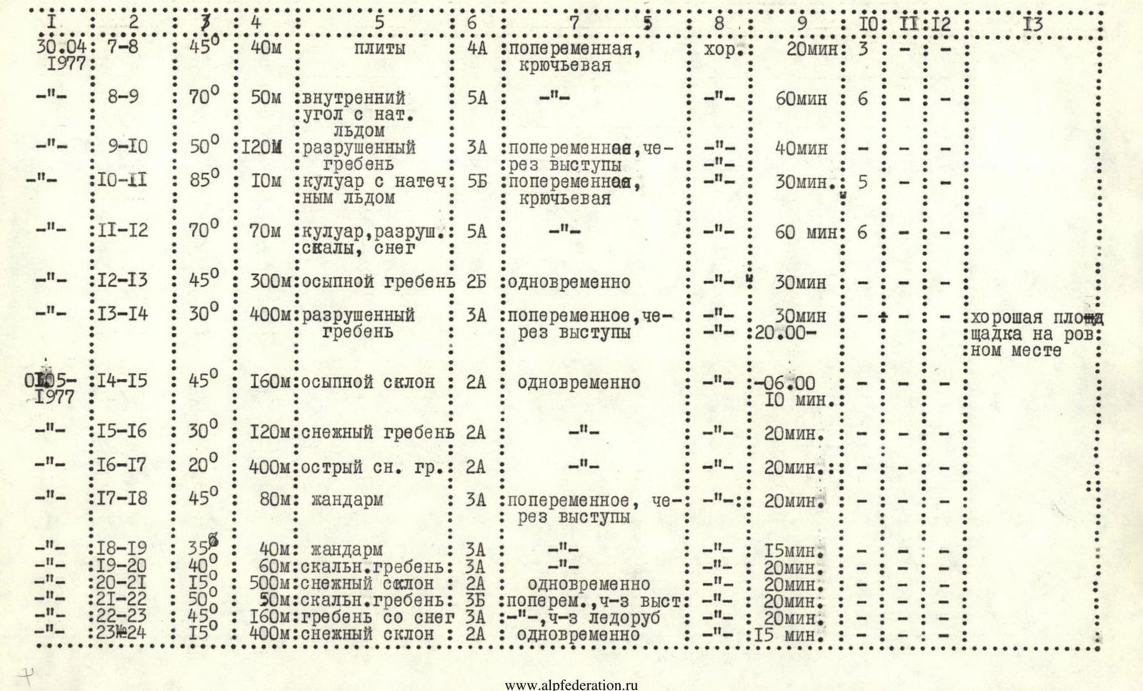
| 1 | 2 | 3 | 4 | 5 | 6 | 7 | 8 | 9 | 10 | 11 | 12 | 13 |
|---|---|---|---|---|---|---|---|---|---|---|---|---|
| 30.04: 7–8 | 45° | 40 m | slabs | 4А | alternate, piton | good | 20 min: 3 | |||||
| 30.04: 8–9 | 70° | 50 m | internal corner with ice | 5А | alternate, piton | good | 60 min: 6 | |||||
| 30.04: 9–10 | 50° | 120 m | degraded ridge | 3А | alternate, through ledges | good | 40 min: — | |||||
| 30.04: 10–11 | 85° | 10 m | couloir with ice | 5Б | alternate, piton | good | 30 min: 5 | |||||
| 30.04: 11–12 | 70° | 70 m | couloir, degraded rocks, snow | 5А | alternate, piton | good | 60 min: 6 | |||||
| 30.04: 12–13 | 45° | 300 m | talus ridge | 2Б | simultaneous | good | 30 min: — | |||||
| 30.04: 13–14 | 30° | 400 m | degraded ridge | 3А | alternate, through ledges | good | 30 min: — | good site on flat ground | ||||
| 01.05: 14–15 | 45° | 160 m | talus slope | 2А | simultaneous | good | —06:00, 10 min: — | |||||
| 01.05: 15–16 | 30° | 120 m | snowy ridge | 2А | simultaneous | good | 20 min: — | |||||
| 01.05: 16–17 | 20° | 400 m | sharp snowy ridge | 2А | simultaneous | good | 20 min: — | |||||
| 01.05: 17–18 | 45° | 80 m | pinnacle | 3А | alternate, through ledges | good | 20 min: — | |||||
| 01.05: 18–19 | 35° | 40 m | pinnacle | 3А | alternate, through ledges | good | 15 min: — | |||||
| 01.05: 19–20 | 40° | 60 m | rocky ridge | 3А | alternate, through ledges | good | 20 min: — | |||||
| 01.05: 20–21 | 15° | 500 m | snowy slope | 2А | simultaneous | good | 20 min: — | |||||
| 01.05: 21–22 | 50° | 50 m | rocky ridge | 3Б | alternate, through ledges | good | 20 min: — | |||||
| 01.05: 22–23 | 45° | 160 m | ridge with snow | 3А | alternate, through ice axe | good | 20 min: — | |||||
| 01.05: 23–24 | 15° | 400 m | snowy slope | 2А | simultaneous | good | 15 min: — |

Talus couloir (section R1–R2). Exit to the first control cairn.

Key location (section R4–R5). Exit from under the overhang with subsequent traverse to the right along a horizontal internal corner, the wall of which also overhangs.
The first climber ascends smooth slabs on section R5–R6.
Alternate movement with protection through ledges along a degraded ridge (section R9–R10).
Ridge section profile, scale 1:20000
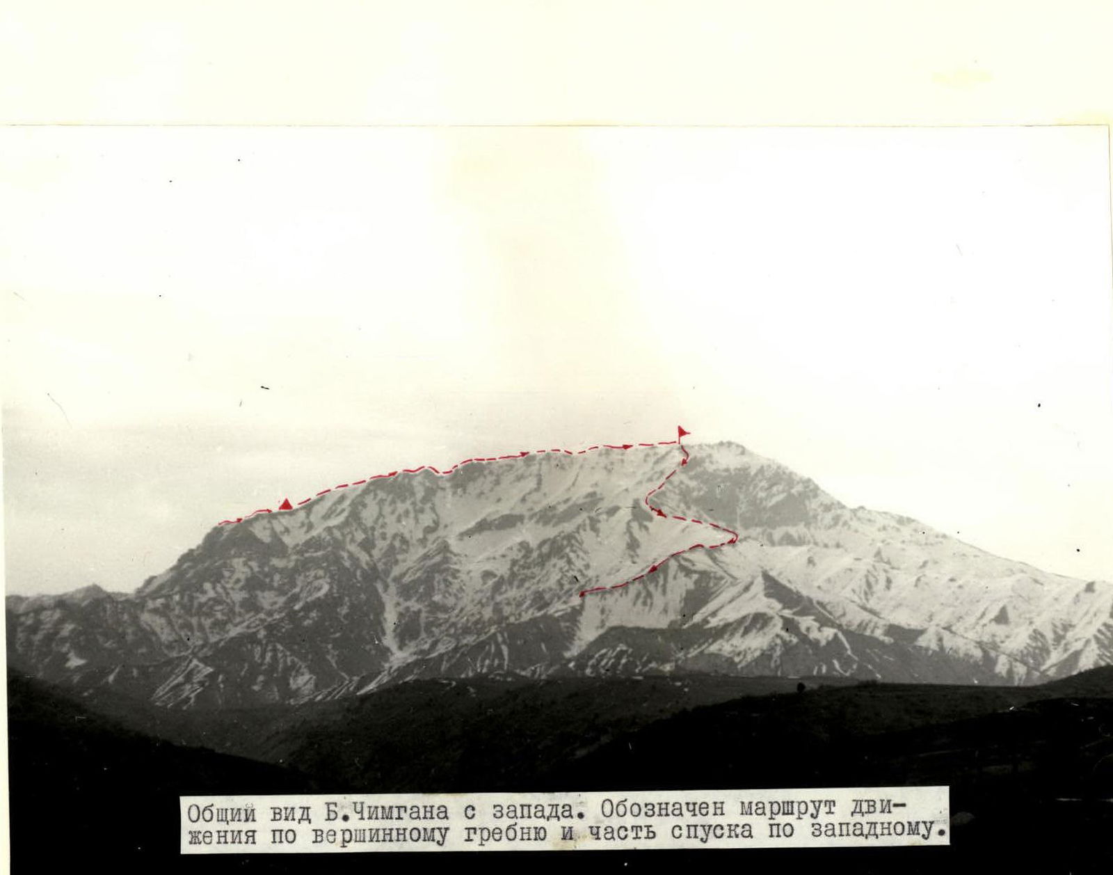
General view of Big Chimgan from the west. The route along the summit ridge and part of the descent along the western ridge are marked.
Comments
Sign in to leave a comment