7.8.3
Climbing Report on Peak Karlytau (5550 m) in July 1968
Almaty Region
1968
INTRODUCTION
From July 18 to August 20, 1968, an expedition from the Kazakh Republican Council of the "Spartak" Sports Society was in the area of the North Inylchek Glacier, with the goal of traversing peaks Shater and Khan-Tengri. To reach the area of operation, it was necessary to cross the Sarydzhas Ridge from the Bayankol valley.
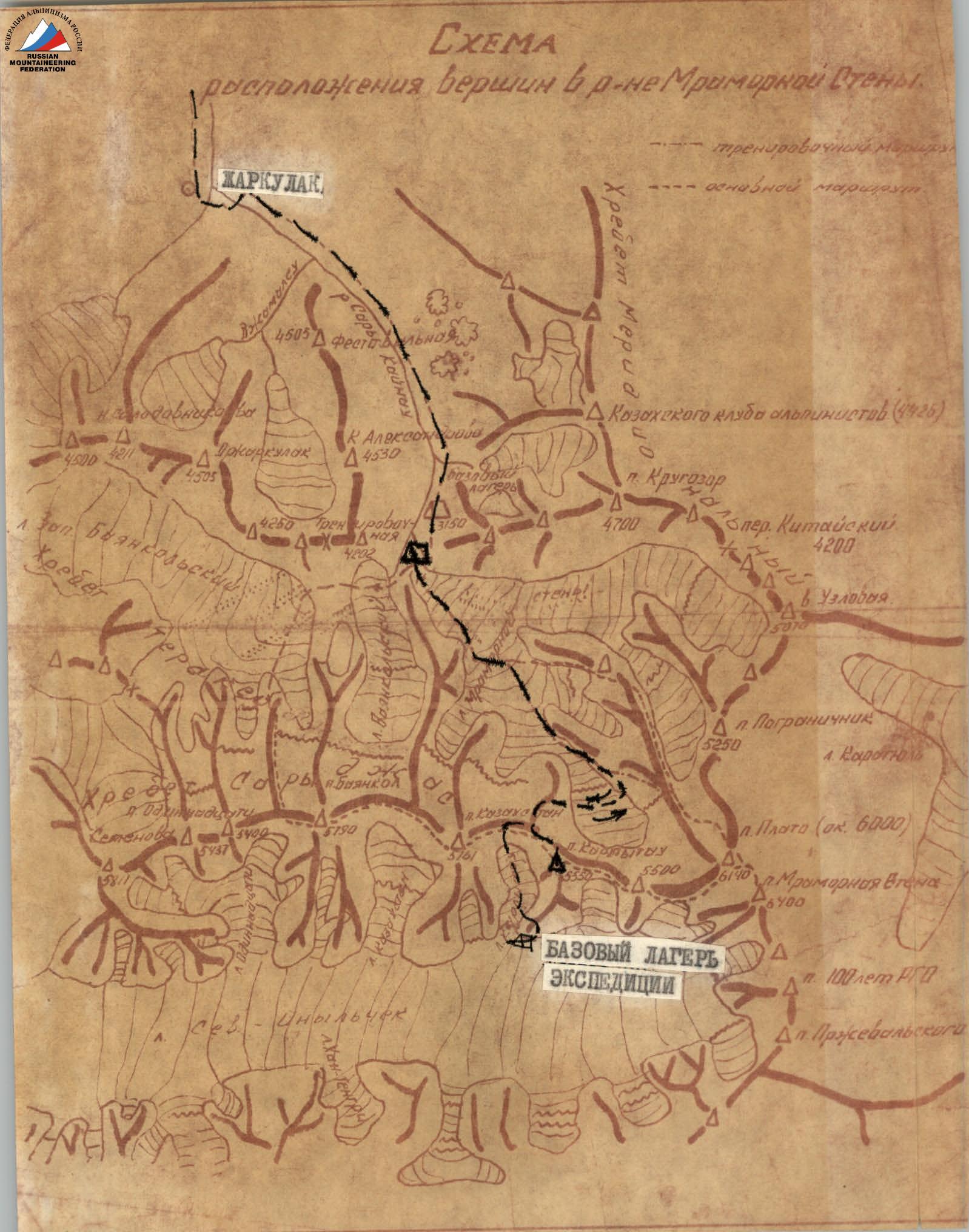
The area around Peak Marble Wall is fairly well-known both geographically and in terms of mountaineering. In 1965, while conducting the northern traverse of the Sarydzhas Ridge, the Kazakh "Spartak" team scouted the Tengri-Tag Ridge as a potential climbing objective. It was clear that the approach from the Bayankol valley to the North Inylchek Glacier was significantly shorter than the approach via Lake Merzbacher, but the Sarydzhas Ridge presented a difficult obstacle. The saddle between peaks Karly-Tau and Kazakhstan seemed the most accessible. A reconnaissance group of 8 people led by V. Popov was sent to scout and prepare the route across the ridge.
The group, departing Almaty on July 18, arrived at the "green" camp under the moraine of the Marble Wall Glacier on July 20. Further, in fulfillment of their task, the group:
- Reached the watershed of the Sarydzhas Ridge via the northwest ridge of Peak Karly-Tau;
- Left their backpacks and ascended to the summit of Karly-Tau;
- Then descended to the North Inylchek Glacier.
The return journey (descent) followed the same path as the ascent.
This report is prepared based on the ascent from the "green" camp and the return to it.
Geographical Location and Climbing Conditions
Peak Karlytau (5550 m) is located in the eastern part of the Sarydzhas Ridge.
V.F. Gusev first ascended Peak Karlytau from the south in 1932.
In subsequent years, the peak was climbed as follows:
- In 1965, the Kazakh "Spartak" team traversed peaks Bayankol — Kazakhstan — Karlytau — Marble Wall from west to east.
- In 1966, Moscow tourists (N. Volkov's group) passed through the Karlytau Pass.
The weather in the area is noted for its unpredictability. Often, in the second half of the day, clouds cover the sky, a sharp wind begins to blow, and snow starts falling. By around 6-7 pm, everything calms down, and the night is usually quiet, except for occasional wind.
The ascent route is snow and ice. In the lower part, one can ascend either through the icefall or via the couloir between the talus ridge (on the left when facing the mountain) and the icefall. The icefall requires significant effort to traverse; the couloir is easier but poses a risk from falling rocks and the ridge, making it more suitable for descent than ascent.
When moving under Peak Marble Wall, there is a risk of ice avalanches from it and avalanches from the ridge (south of the wall itself), so it's necessary to pass this section before 11-12 am. The exit from this section to the start of the ascent ridge is technically challenging but safe.
The direct ascent route to the summit follows a snowy slope with ice walls. The snow is deep and unstable, so for safety, the team navigated through the ice walls, using ice screws for protection.
Potential risks include:
- Triggering an avalanche while moving on the slopes.
- The route should not be attempted after heavy snowfall due to avalanche danger, particularly in the middle part of the ascent.
The final ascent to the summit is straightforward, following a corniced ridge. The summit is snowy, and there's no suitable place to build a cairn. The descent followed the same route as the ascent.
The nearest settlement is considered to be the shepherd's house in Dzharkulak (8-10 km from the "green" camp). The border post in the settlement of Bayankol is 27 km from Dzharkulak. Vehicles can reach:
- Dzharkulak in dry weather,
- Ashutora in rainy weather.
III. Itinerary and Composition of the Ascent Group
The following itinerary was planned for the ascent:
- Day 1: "Green" camp I (3700 m)
- Day 2: Camp I – Camp 2 (4700 m) on the ridge
- Day 3: Camp 2 – summit – Camp 3 (4700 m) – back to Camp 2
- Day 4: Camp 3 – "green" camp
There were no deviations from the plan. The composition of the ascent group was:
- Popov V.I. — leader
- Afanasyev A.
- Afraimovich E.
- Zapeka V.N.
- Kambarov E.K.
- Kireev G.
- Kondrashov I.V.
- Sagadeev R.M.
No new equipment was used.
IV. Route Description
Day 1
R1. We depart from the "green" camp at the terminal moraine of the Marble Wall Glacier in the morning. The path along the glacier is straightforward but lengthy. We approach the icefall descending from the Marble Wall. We inspect the start of the ascent. The couloir between the talus ridge and the icefall is tempting but hazardous due to falling rocks. We decide to ascend via the icefall.
R2. The icefall is broken, requiring us to overcome walls up to 10-15 m long and with a steepness of up to 70°. We ascend with step-cutting and ice screw placement. The weather deteriorates with snow and wind. On flat sections, the snow is deep, and the lead climber changes frequently. After overcoming the steep drop of the icefall, we reach a relatively gentler but still broken section. Ahead, we see another steep rise with large crevasses that are difficult to pass. We begin to move leftwards towards the mentioned ridge. We reach the right (orographic) bank of the icefall, establish two descents down ice walls (20-25 m), with the last one using a rappel. We immediately find a large, safe area from falling rocks, clear it, and set up a tent. The altitude is 3700 m (Camp I).
Day 2
The night was relatively calm, with wind throughout. We departed at 8 am.
R3. We move along the couloir on a talus slope. We need to exit the couloir before it gets exposed to sunlight to avoid rockfall.
R4. We traverse the snowy plateau under the Marble Wall. The snow is deep, requiring us to dig a trench. It's hard to walk, and the lead climber changes frequently. We encounter large ice chunks, likely from the hanging glacier of the Marble Wall.
R5. We pass a snowy slope with equally deep snow. To our right is the icefall we initially traversed. We encounter avalanche debris from the Marble Wall ridge, which eases our path but necessitates a quicker pace due to the risk of avalanches. We rest on a flat snowy plateau after passing this section.
R6. We traverse another snowy plateau. The walking is easy.
R7–R8. We begin ascending the ridge leading to Peak Karly-Tau. The snow is not deep; occasionally, we encounter firn.
R9. A long (150 m) ice slope.
- The lead climber cuts steps where necessary and proceeds on the front points of their crampons.
- At points of belay, we cut large steps — platforms.
- Belay is via ice screws.
–12–
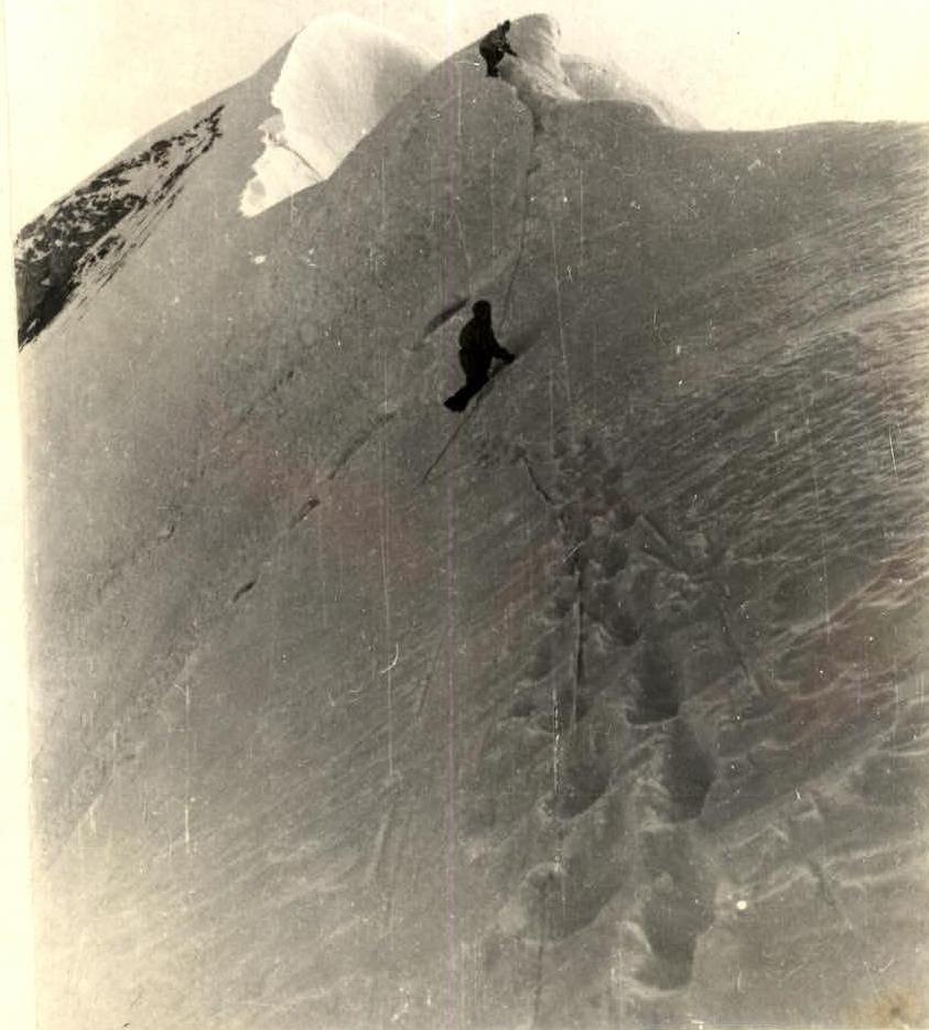
R10. Ahead lies an overhanging crevasse edge. It can be bypassed by traversing right for 50–60 m, but this would be strenuous. We decide to tackle it head-on. Afanasyev, with 3 ice axes, begins to ascend a 4-meter snow wall (75–80°), reaches the crevasse edge, and carefully crosses it on a thin snow bridge. The crevasse is 3–3.5 m wide. He then sets up a belay 10 m further, using an ice screw. Wind and snow.
R11–R13. We ascend a snow and ice slope to reach the ridge, which forms a shoulder about 15–20 m wide. It's late, so we build a windbreak, set up tents. From here, we can proceed to the summit without backpacks. The altitude is 4700 m.
Day 3
R14. We move along the ridge. The snow is waist-deep, making progress difficult and lengthy. Finally, we approach an ice wall. It can be bypassed via a steep snowy slope on the left, but given the snow conditions, this is risky.
R15. We tackle the ice wall head-on. The ice is good, and steps are cut easily. Belay is via ice screws.
R16. We ascend a snowy slope to the next ice section. The snow is deep; we proceed with caution, using belays:
- via an ice axe (mid-slope),
- ice screws (at the edges).
R17–R20. The process is similar to the previous sections R15–R16.
R21. We overcome a short, steep ice wall (15 m, 70°). Above it lies an ice-firn slope. Continuing directly would lead to more ice walls. We decide to traverse left, which later allows us to ascend a less steep snowy slope after one snowy section.
R22. We traverse left for 40 m. We occasionally cut steps in the ice; mostly, we walk on firn, carefully making steps with our feet. Belay is via ice screws.
R23. A snowy slope of 80 m, with very deep and loose snow. We must be cautious to avoid triggering an avalanche. The lower belay is via an ice screw. As we approach an exposed ice section, we immediately place an ice screw for belay. We rest together.
R24. Ahead and to the left is a diagonal crevasse in the slope. We pass it along its upper edge, cutting steps in dense firn to reach the ice. Belay is via ice screws. It's uncomfortable as the left foot often hangs in void. A direct ascent is challenging due to the steepness (up to 80° ice).
R25–R26. We ascend snowy slopes to reach the ridge leading to the summit from the saddle between peaks Karly-Tau and Kazakhstan. The ascent is easier than the previous sections, but an approaching fog is a concern. Wind starts as expected. Visibility is 20–30 m.
R27–R28. We ascend to the highest point of Peak Karly-Tau via a corniced ridge. The summit is snowy, with no rock outcrops, so there's no cairn. Khan-Tengri occasionally appears in the fog. We begin our descent.
R29. The descent to the camp at 4700 m follows the ascent route. We rappel down ice walls, with the last rappel using a double rope. We overnight at the 4700 m camp.
Day 4
R30. We descend via the ascension route to the glacier. We proceed to the "green" camp via the glacier.
V. Evaluation of the Group's Actions
All group members have been climbing together for the past 6 years. The group has significant experience in winter ascents:
- Talarskaya Podkova (1965),
- Peak Marble Wall in winter (1966),
- Traverse of Aksai semi-Podkova (1967).
This experience greatly facilitated the task. The group's friendly atmosphere and mutual assistance were noteworthy. On challenging sections, the lead climber changed as per the plan.
All group members were well-prepared both tactically and technically, allowing for a relatively quick ascent.
VI. Conclusion
Comparing the ascent route of Peak Karly-Tau with previously climbed routes (Peak Komsomol via the NE ridge, traverse of Tuyuk-Su Podkova, traverse of Talgar), the group believes the route deserves a category 3B difficulty rating.
On behalf of the team —
(V. POPOV)
Table of Main Characteristics of the Ascent on Peak Karly-Tau (5500 m)
| № | Section | Steepness of Section (°) | Length of Section (m) | Characteristics of Section and Conditions of Passage (Relief, Complexity, Method) | Weather | Start Time | Stop Time | Walking Hours | Hooks Driven | Overnight Conditions | Ration Weight (g) |
|---|---|---|---|---|---|---|---|---|---|---|---|
| 1st day | R1 | 10000 | Movement along the glacier from the "green camp" 3200 m. (Easy, simultaneous movement) | Good | 9:00 | 17:30 | 8:30 | 1000 | |||
| R2 | 20–25 | 750 | Passage through the icefall with ice walls up to 20 m, length and steepness 60–75°. (Difficult, alternating movement with step-cutting, belay via ice screws) | Snow, wind | 4 | Camp I (3700 m), wind throughout the night | |||||
| 2nd day | R3 | 30 | 250 | Movement along the couloir between the talus slope and the icefall. (Medium, simultaneous movement) | Good | 8:00 | 18:30 | 10:30 | 1000 | ||
| R4 | 10–15 | 1000 | Snowy plateau under the Marble Wall, deep snow. (Easy, simultaneous movement) | Good | |||||||
| R5 | 30–35 | 200 | Snowy slope, deep snow. (Medium, simultaneous movement) | Good | |||||||
| R6 | 5–10 | 600 | Snowy plateau. (Easy, simultaneous movement) | Overcast | |||||||
| R7 | 45 | 350 | Snow-firn slope. (Medium, alternating movement, belay via ice axe) | Wind | |||||||
| R8 | 35–40 | 60 | Snow-firn slope. (Medium, alternating movement, belay via ice axe) | Wind, snow | |||||||
| R9 | 55 | 150 | Ice slope. (Difficult, alternating movement with step-cutting, belay via ice screws) | Gusty wind with snow | 7 | ||||||
| R10 | 70 | 10 | Snow bridge over a crevasse. (Difficult, alternating movement, belay via ice screws and ice axe) | Wind, snow | 1 | ||||||
| R11 | 40 | 60 | Snow-firn slope. (Medium, alternating movement, belay via ice axe) | Strong wind, snow | |||||||
| R12 | 45 | 40 | Ice slope. (Medium, alternating movement, belay via ice screws) | Snow, wind | 2 | ||||||
| R13 | 45 | 120 | Snow-firn slope, exit to the ridge. (Medium, alternating movement, belay via ice axe) | Wind, snow | Camp 2 (4700 m), wind | ||||||
| 3rd day | R14 | 10–15 | 500 | Snowy ridge with deep snow. (Easy, simultaneous movement) | Good | 8:00 | 19:00 | 11:00 | 1000 | ||
| R15 | 60–65 | 30 | Ice wall. (Difficult, alternating movement with step-cutting, belay via ice screws) | Good | 2 | ||||||
| R16 | 45 | 60 | Snowy slope. (Medium, alternating movement, belay via ice axe) | Good | |||||||
| R17 | 65 | 40 | Ice wall. (Difficult, alternating movement with step-cutting, belay via ice screws) | Good | 2 | ||||||
| R18 | 45 | 40 | Snowy slope. (Medium, alternating movement, belay via ice axe) | Good | |||||||
| R19 | 65–70 | 30 | Ice wall. (Difficult, alternating movement with step-cutting, belay via ice screws) | Good | 2 | ||||||
| R20 | 45 | 60 | Snowy slope. (Medium, alternating movement, belay via ice axe) | Good | |||||||
| R21 | 70 | 15 | Ice wall. (Difficult, alternating movement with step-cutting, belay via ice screw) | 1 | |||||||
| R22 | 45 | 40 | Ice-firn slope. (Medium, alternating movement, belay via ice axe and ice screw) | Good | 1 | ||||||
| R23 | 45 | 80 | Snowy slope with deep snow, avalanche risk. (Difficult, alternating movement, belay via ice axe) | Good | |||||||
| R24 | 55–60 | 30 | Ascent along the crevasse edge, ice. (Difficult, alternating movement with step-cutting, belay via ice screws) | Good | 2 | ||||||
| R25 | 45 | 300 | Snowy slope. (Medium, alternating movement, belay via ice axe) | Fog, wind | |||||||
| R26 | 40 | 60 | Exit to the ridge via a snowy slope. (Easy, simultaneous movement) | Wind | |||||||
| R27 | 30 | 300 | Movement along a corniced ridge. (Easy, simultaneous movement) | Wind | |||||||
| R28 | 20 | 120 | Ascent to the summit via a corniced ridge. (Easy, simultaneous movement) | Wind | |||||||
| R29 | see sections R28–R14 | Ascent to the summit via a corniced ridge, descent to Camp 3. (Easy and difficult, simultaneous movement, belay via ice axe, ice screws, pitons) | Wind, fog | –2 | Camp 3 (4700 m) | ||||||
| 4th day | R30 | see sections R13–R1 | Descent to the glacier and further to the "green camp". (Medium and difficult, alternating and simultaneous movement, belay via ice axe, ice screws, pitons, etc.) | Good | 10:00 | 18:00 | 8:00 | 2 | Good, "green" camp (3200 m) | 1000 |
Total: 38:00 walking hours, 28 hooks driven.


