Description of Approaches to the Start of Routes to Peaks in the Chon-Uryukty Glacier Area
From the base camp at the fork of the Chon-Uryukty River, follow the trail south to Mahabatkol Lake (40 min.), then along the valley along the stream to the base of the moraine up a steep grassy slope, and then up a steep scree to ascend to the moraine of the Chon-Uryukty glacier. (40–50 min.) Continue past the glacial lake to the northern slopes of Crystal Peak. (40 min.) Here are the starting points for the routes:
- Via the NE edge, category 3A difficulty
- North ridge, category 2B difficulty to Crystal Peak.
From this location, it takes 1 hour to walk south, bypassing the eastern ridge of Crystal Peak, to the base of the couloir where routes to Dragon Peak via the western ridge and Crystal Peak via the SE ridge begin.
To access the route to Aisulu Peak via the North ridge, from Mahabatbatkul Lake, head south along the valley for 15 minutes, then left up a steep grassy slope with individual rock outcrops to a wide area. (40 min.) Continue southeast along the lateral moraine of the glacier to the foot of a rocky outcrop. Here, ascend to the moraine and move south towards the North ridge of the peak:
- first across rocks,
- then across ice.
To access the route to Ruslan Peak via the North ridge, from Mahabatbatkul Lake, follow the trail south, then west for 30 minutes, then ascend to the moraine opposite the North ridge of Ruslan Peak and move along it towards the base of the couloir through which the route passes. (1 hour)
Ascent Passport
- Type of ascent — combined
- Region of ascent — Tian Shan, Kungey Alatau range
- Peak — Aisulu, height — 3810 m, route via the North ridge
- Estimated difficulty category — 2B
- Route characteristics:
- height difference — 440 m
- average steepness — 35°
- sections of category 5 difficulty — none
- Pitons driven:
- for belaying — 6, for creating artificial protection — none, rock — 4, ice — 2
- Overnight stays on the route — none
- Number of climbing hours — 8 hours
- Group composition: Staroselеts E.V., Master of Sports, leader; Gorshenin S.G., III sports category, participant; Solomatova V.A., III sports category; Saulevich V.I., III sports category
- Team coach — II sports category
- Date of departure on the route and ascent — August 10, 1981
TABLE OF MAIN ROUTE CHARACTERISTICS
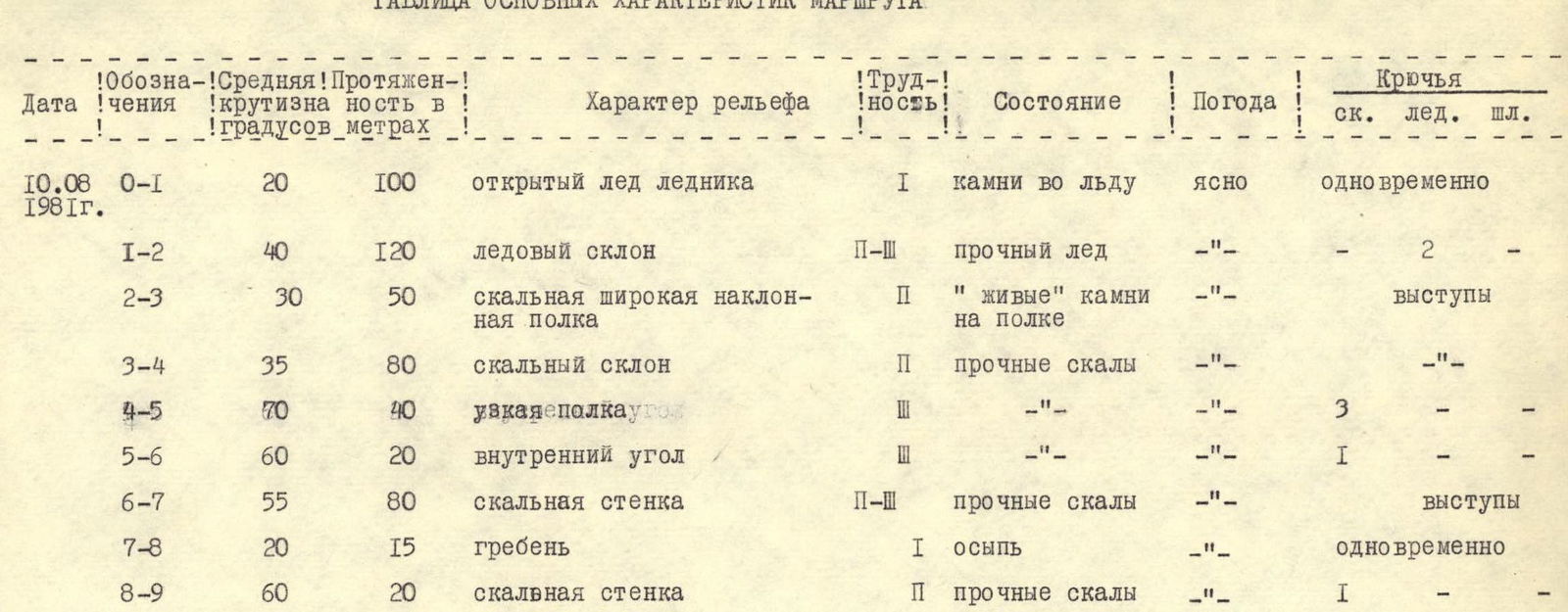
| Designation | Average steepness in degrees | Length in meters | Nature of relief | Difficulty of section | Condition | Weather | Pitons (rock) | Pitons (ice) | Pitons (bolts) |
|---|---|---|---|---|---|---|---|---|---|
| August 10, 1981 R0–R1 | 20 | 100 | open glacier ice | 1 | rocks in ice | clear | simultaneous | - | - |
| R1–R2 | 40 | 120 | ice slope | 2–3 | solid ice | - | 2 | - | - |
| R2–R3 | 30 | 50 | wide rocky inclined shelf | 2 | "live" rocks on shelf | - | ledges | - | - |
| R3–R4 | 35 | 80 | rocky slope | 2 | solid rocks | - | - | - | - |
| R4–R5 | 70 | 40 | narrow shelf-step | 3 | - | - | 3 | - | - |
| R5–R6 | 60 | 20 | inner corner | 3 | - | - | 1 | - | - |
| R6–R7 | 55 | 80 | rocky wall | 2–3 | solid rocks | - | ledges | - | - |
| R7–R8 | 20 | 15 | ridge | 1 | scree | - | simultaneous | - | - |
| R8–R9 | 60 | 20 | rocky wall | 2 | solid rocks | - | 1 | - | - |