Russian Mountaineering Championship
2016, high-altitude technical class. Report on the ascent of the Krasnoyarsk Krai team to Great Wall of China Peak (5186 m) via the center of the southeast wall, "Tears of the Dragon" - first ascent, approximately 6B category.
KRASNOYARSK 2016
Ascent Passport
- Region — Tian Shan, West Kokshaal-Too range.
- Peak — Great Wall of China (5186 m), ascent via the center of the southeast wall, first ascent.
- Category — 6B category, first ascent.
- Route type — combined.
- Route characteristics:
- Main section height difference — 820 m,
- Route length — 1210 m,
- Length of 6th category sections — 620 m,
- Average steepness of the main section — 76°,
- Average steepness of the route — 72°.
- Equipment left on the route: total — 16 pcs., including 13 bolts. Team's working hours: 38 hours, 3.5 days. Number of nights: on the route — 3, on descent — 1.
- Team leader: Prokofiev Denis Evgenevich, Master of Sports.
Team members:
- Popova Marina Evgenevna, Master of Sports.
- Sysoev Vladimir Alexandrovich, Candidate for Master of Sports.
- Babushkina Olesya Mikhailovna, Candidate for Master of Sports.
- Team coaches:
- Zakharov Nikolai Nikolaevich, International Master of Sports, Honored Coach.
- Balezin Valerii Viktorovich, International Master of Sports.
- Prokofiev Denis Evgenevich, Master of Sports.
- Start of the ascent: 7:40 AM, July 20, 2016. Summit reached: 3:20 PM, July 23, 2016. Return to Base Camp: 5:00 PM, July 24, 2015.
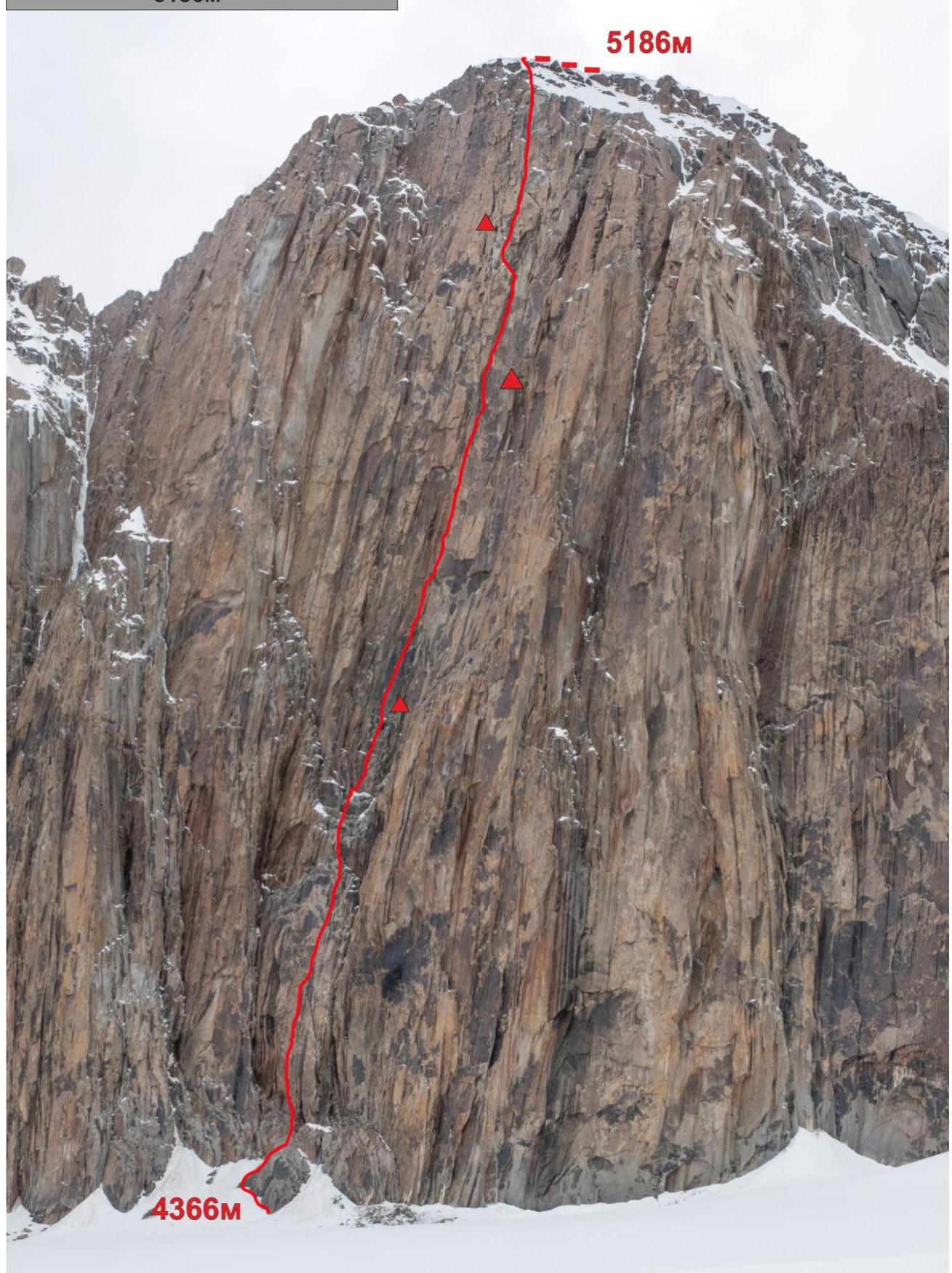
Overall photo of the southeast wall of Great Wall of China 5186 m
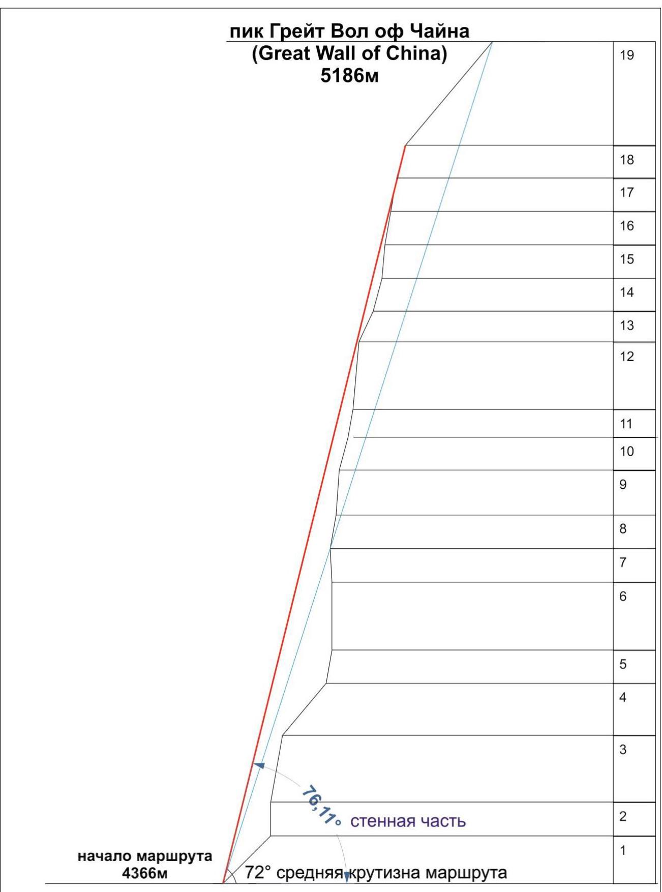 Drawn profile of the route
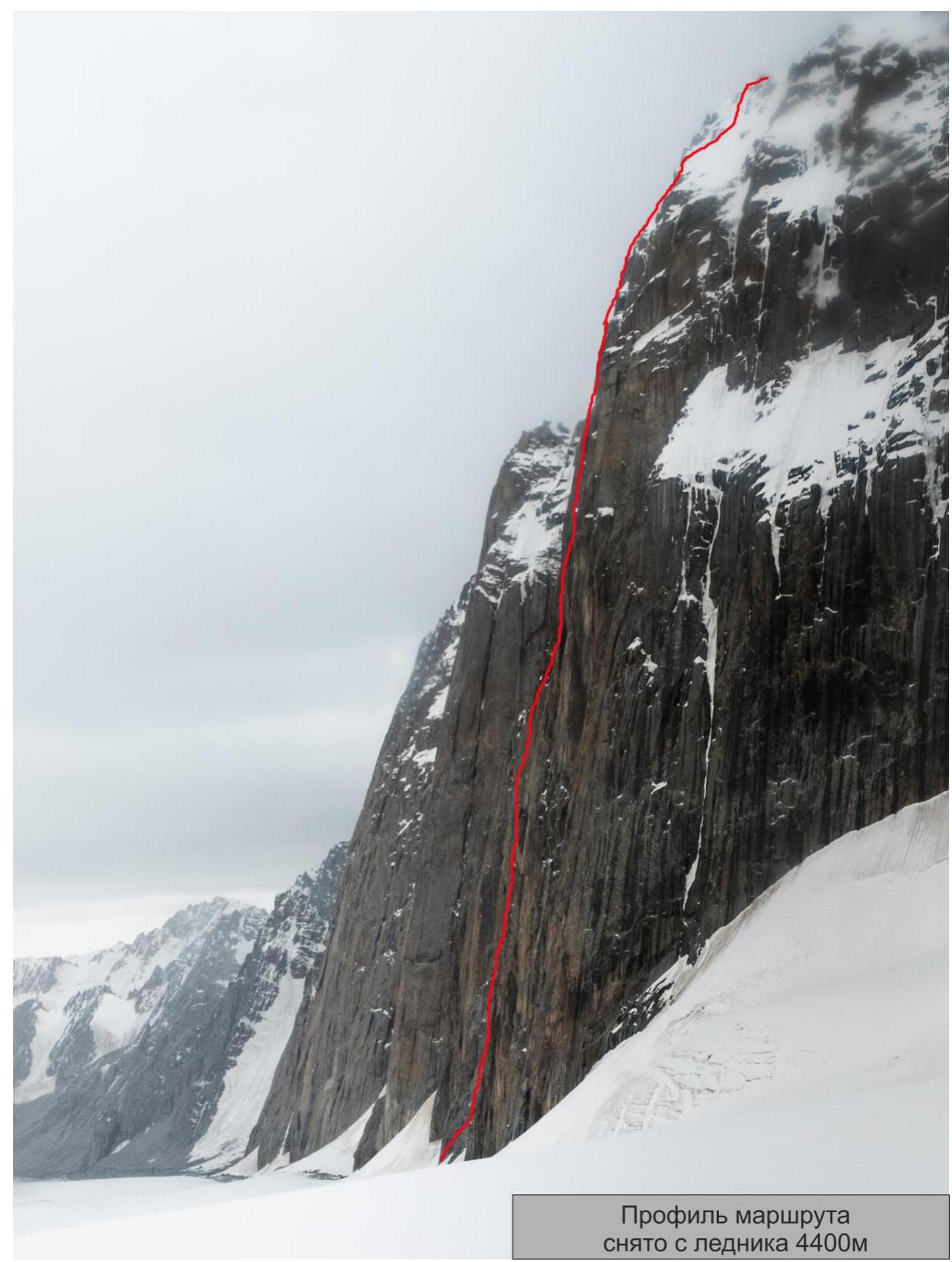 Profile of the route from the 4400 m glacier
Area Photopanorama
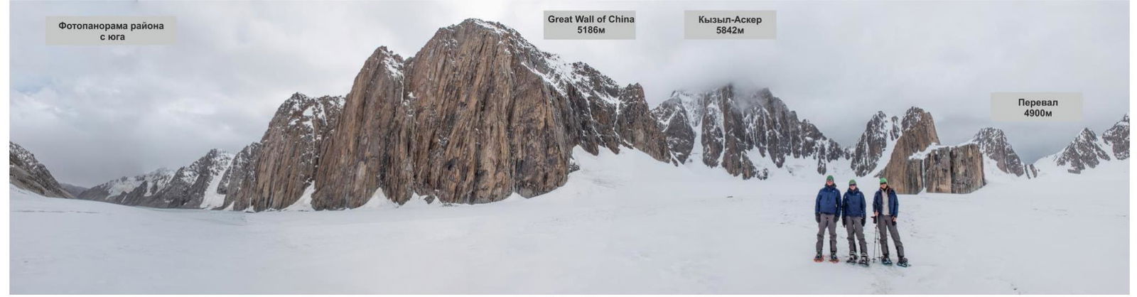
Area Overview
The area around Kyzyl-Asker Peak (5842 m), Central Tian Shan, West Kokshaal-Too range is characterized by highly unstable weather. The "sun-snow-storm" cycle changes several times a day.
The base camp is set up at an altitude of 3900 m. The snow line is around 4000–4500 m above sea level. Valley bottoms have high absolute altitudes of around 3000–3500 m.
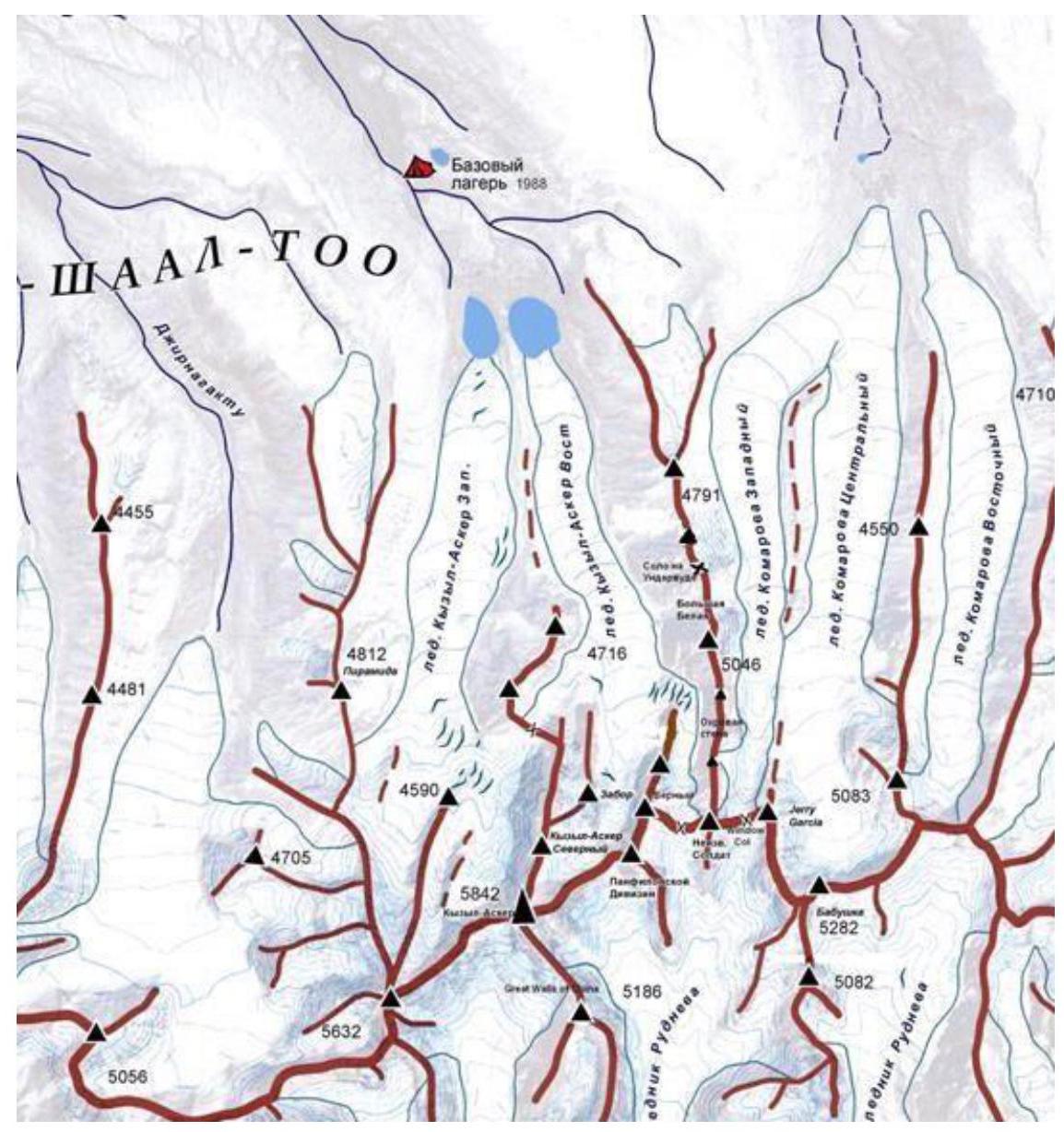
The approach to the cirque where Great Wall and the southeast wall of Kyzyl-Asker are located involves:
- crossing the Komarov Glacier,
- followed by a 4900 m pass.
This takes around 13 hours with snowshoes and a hard snow base.
Great Wall of China Peak, 5186 m, is located in the southern spur of Kyzyl-Asker. The peak consists of three vertical rock bastions.
Features:
- Uncharted peak (no wall ascents have been made).
- Steepness of the wall. The main part of the wall is a series of vertical sections (80–90°) and cornices. Caution is required on descent as several rappels had to be made to bolts.
- Monolithic terrain visible from the glacier.
- Absence of a long, gentle "roof." The terrain becomes gentle only in the last 50–120 meters when reaching the ice.
There is only one recorded ascent on Great Wall, and it was not a wall ascent. The first ascent was made in August 2013 by Dutch climbers Visser and Perrin via the "Double Trouble" route (TD–, AI4, 800 m) on the Northeast wall.
No successful wall ascents have been recorded, with only a few attempts made. On the first rock bastion, 90 meters from the ground on descent, we saw one bolt; there were no other signs of previous ascents.
Thus, the team made the first wall ascent on the peak. The chosen route follows the most logical line, passing through the center of the wall, and is also the safest due to a large internal angle protecting the route from falling rocks and ice. The terrain is mostly monolithic and is clearly visible from below.
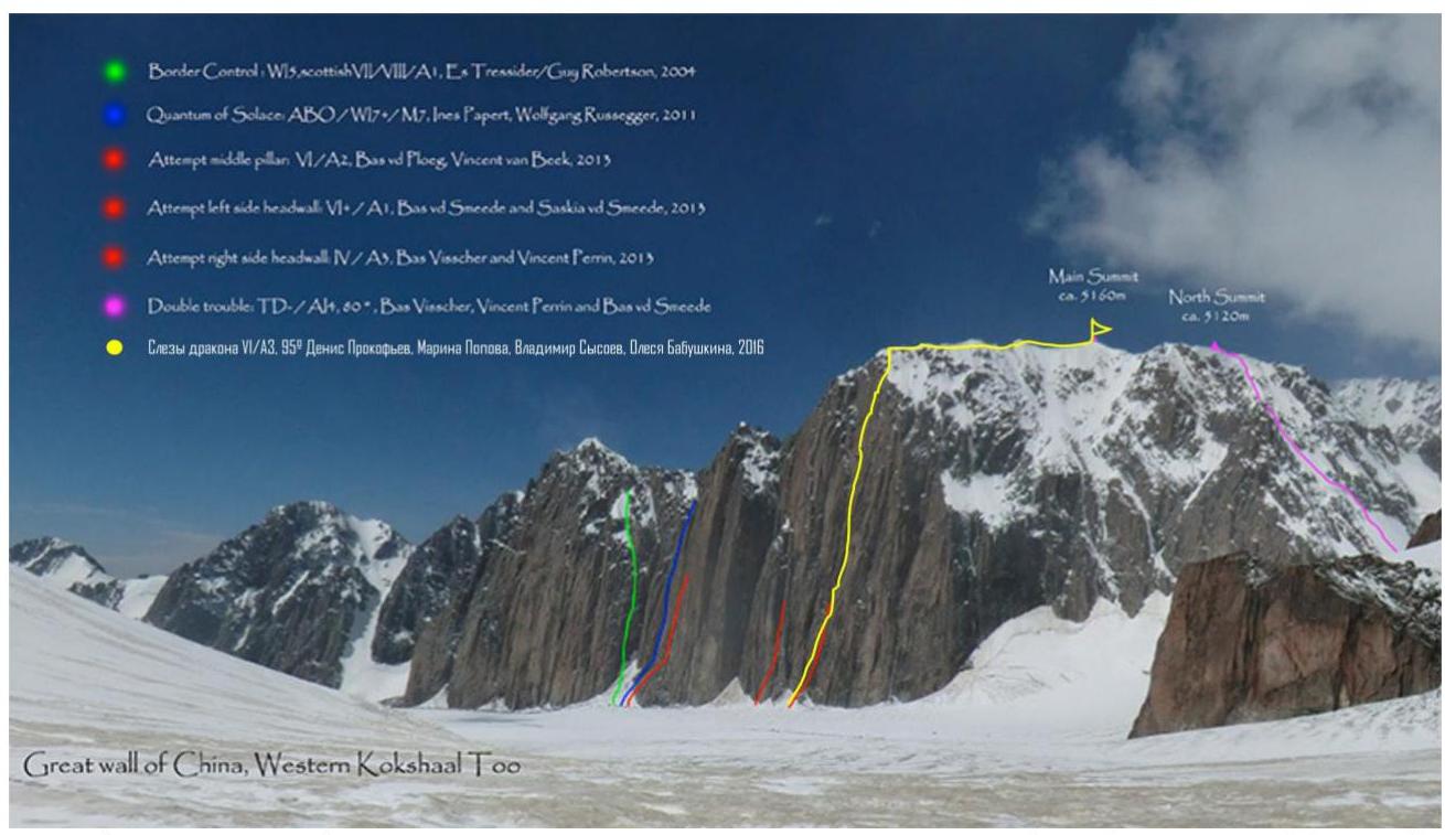 Graphical representation of all known attempts and ascents on the wall. The yellow line represents the team's route; the purple line on the right is the only successful ascent (internet photo), taken from the ascent to the 4900 m pass.
Team Tactics
The team acclimatized by climbing simple peaks near the base camp. They made a night camp at 4800 m on the snow peak "Ekstasy," one of the peaks adjacent to "Gronky" (Big White) 5050 m. They also visited the Komarov Glacier and made a cache of some supplies.
On July 18, 2016, they left the base camp with equipment, one tent, and one platform (shared among four team members). They retrieved the cached supplies en route and reached the glacier via the 4900 m pass, where they set up Camp ABC.
The next day, they searched for a logical and feasible line for the first ascent. Plans to climb Kyzyl-Asker were postponed. The line initially planned in Krasnoyarsk was covered in ice and snow, and after each period of bad weather, it became less appealing.
The weather on the glacier changes approximately every 2–4 hours: sun, followed by a snowstorm. On July 19, the team approached the Great Wall, identified the line for the first ascent, and cached equipment at the start of the route. The approach to the route is straightforward: a 40-minute walk on the glacier (closed) slightly descending from ABC.
On July 20, at 7:40 AM, they began the ascent without prior route preparation, carrying a platform. The first climber used a double dynamic rope, while the second carried minimal weight. The third and fourth team members carried the main load. Bolts for rappel were placed every 60 meters on vertical sections with overhangs by the third or fourth climber. This allowed the lead climber to move as quickly as possible.
The lead climber changed daily (Day 1: O. Babushkina, Day 2: M. Popova and D. Prokofiev, Day 3: V. Sysoev, Day 4: D. Prokofiev).
Lighting and temperature conditions:
- Sun shines from morning until 1:00–1:30 PM.
- Around 3:00 PM, water starts flowing down the wall when the sun no longer shines on it.
- By 5:00 PM, everything starts to freeze.
There was no issue with water; they hung the platform near small snow ledges. The terrain is very steep, and there are no suitable spots for a tent. There are ledges on sections 5–6, but they are all exposed to falling ice and rocks, making it deadly to set up a tent.
Descent followed the ascent route:
- The route was largely equipped with bolts for rappel every 60 kg.
- Except for gentle sections with good terrain, anchor hooks were left in place.
Area Map
Ascent Schedule
| Height, m | July 20, 2016 | July 21, 2016 | July 22, 2016 | July 23, 2016 | July 24, 2016 |
|---|---|---|---|---|---|
| 5186 | clear, temperature drop, +1°C | ||||
| 4950 | sunny, cloudy after 2:00 PM | clear in the morning, fog after 1:30 PM, snow | snow, clouds, wind | ||
| 4780 | |||||
| 4546 | |||||
| 4366 | 10 working hours | 11 working hours | 10 working hours | 7 working hours | descent |
Route Diagram in UIAA Symbols
| Section Number | Length, m | Steepness, degrees | Difficulty |
|---|---|---|---|
| R9–R10 | 30 | 75 | VI A2-A3 |
| R8–R9 | 60 | 80–95 | VI A2 |
| R7–R8 | 30 | 80 | VI A2 |
| R6–R7 | 30 | 90–95 | VI A2-A3 |
| R5–R6 | 60 | 80–95 | VI A2-A3 |
| R4–R5 | 30 | 80 | VI A1 |
| R3–R4 | 60 | 50 | V |
| R2–R3 | 60 | 80 | VI A1 |
| R1–R2 | 30 | 90 | VI, A2 |
| R0–R1 | 60 | 45 | III |

| Section Number | Length, m | Steepness, degrees | Difficulty |
|---|---|---|---|
| R20–R21 | 130 | II | |
| R19–R20 | 120 | 45–60 | III–IV |
| R18–R19 | 10 | 80–95 | VI A2 |
| R17–R18 | 30 | 75 | VI A2 |
| R16–R17 | 30 | 80 | VI A3 |
| R15–R16 | 30 | 80 | VI A2 |
| R14–R15 | 30 | 85 | VI A3 |
| R13–R14 | 30 | 75 | VI A2 |
| R12–R13 | 30 | 65 | VI A1 |
| R11–R12 | 60 | 85 | VI A3 |
| R10–R11 | 25 | 80 | VI A2 |
Route Description by Sections
- Traverse a pronounced rock genie on the left via simple, crumbling rocks, approach under a vertical wall starting with an overhang. 60 m, 45°, III.
- Up through the overhang via a crack, onto the wall, pendulum right (1.5 meters), then up via cracks (friends, stoppers). 30 m, 90°, VI, A2.
- Up the wall via good-sized cracks. 60 m, 80°, VI, A1.
- The wall ends, and it starts to flatten; there are loose rocks. A series of ledges and walls 3–5 meters high. The general direction is up, towards a large vertical internal angle going across the main part of the wall from left to right. Be cautious as this part of the wall may be hit by ice and rocks from the "roof" after 12:00 PM. 60 m, 50°, VI.
- Via a destroyed chimney, approach under a pronounced internal angle, start of the black wall. Set up the first bivouac platform here, and hammered in an additional bolt into the slab (used for rappel on descent). The spot is convenient and protected from falling rocks and ice (shielded by a large overhanging internal angle); a few meters below, there's a narrow, sloping ledge with snow. 30 m, 80°, VI, A1.
- Move up and slightly right along the internal angle via cracks. The terrain is black. The wall is vertical, 80°. There are "live" narrow slabs in the crack; movement is cautious and careful. The wall gradually becomes steeper, ending in an overhang. The rope is "diagonal" from left to right. A bolt is placed on the station. 60 m, VI, A3 (30 m, 80°; 25 m, 90°; 5 m, 95°).
- Pass a cornice on the right and continue up. The wall is vertical. 8 m, 95°, VI, A3; 22 m, 90°, VI, A2.
- 30-meter section, movement via a system of cracks: wide chimneys, with a pendulum right of 3 meters at the end, approaching an overhang from the right. 30 m, 80°, VI, A2.
- Through a slightly overhanging bulge (large cornice on the left), to "feathers" on the right, up and right, bypassing a large cornice via hanging thin cracks, reaching a ledge, station. 40 m, 80°, VI, A2; 20 m, 95°, VI, A2.
- The wall becomes more gentle, but the cracks are blind. 15 m up the wall, then left into an internal angle (horizontal traverse about 3 m); the left wall overhangs. Set up a platform here. There's a ledge with snow 30 meters below, but it's washed by water and hit by falling ice. 30 m, 75°, VI, A2-A3.
- Move up the internal angle. The left wall overhangs; the terrain inside the angle is partially destroyed. Movement is cautious. 25 m, 80°, VI, A2.
- Up the angle, with some destroyed rocks; part of the section is on the overhanging left wall; the upper part is iced. The angle ends — exit left onto a ledge. There's a bolt. 60 m, 85°, VI, A3.
- From the ledge, move left and up, bypassing a large cornice; station under an overhang, on a sloping snow ledge. 30 m, 65°, VI, A1.
- Up two parallel cracks filled with ice; station on a small ledge. There's a bolt. 30 m, 75°, VI, A2.
- Ahead is a wall with a large cornice. The cornice is bypassed on the right. The third bivouac platform was hung under the cornice on the left. For the platform, a bolt was hammered in. On the overhanging wall, into an ice-filled chimney-gully (very unreliable ice); up the gully 4 m, then right onto a thin crack with ice; up the crack, which ends; two steps on skyhooks right and up; exit onto a ledge. 30 m, 85°, VI, A3.
- Vertical internal angle with ice. There's a bolt on the station. 30 m, 80°, VI, A2.
- Destroyed rocks, moving up, veering slightly right. Chimney-offwidth (narrow chimney) filled with ice. Insurance is unreliable; short ice screws are half-way in; anchors. Some sections are impossible on ITO. 30 m, 85°, VI, A3.
- Up the wall via wide cracks-offwidths with ice; requires the ability to climb narrow chimneys. Few insurance points. There's a bolt on the station. 30 m, 75°, VI, A2.
- Up, exiting through an overhang onto the "roof"; lots of ice. Bolt on the station. Left a control cairn with a note. 10 m, 85°, VI, A3.
- Up the ice and through a snow cornice onto the ridge. 90 m, 45°, III; 30 m, 60°, IV.
- Along the ridge to the summit, 130 m, II.
Descent followed the ascent route.
Technical Photos
Great Wall of China — 5186 m
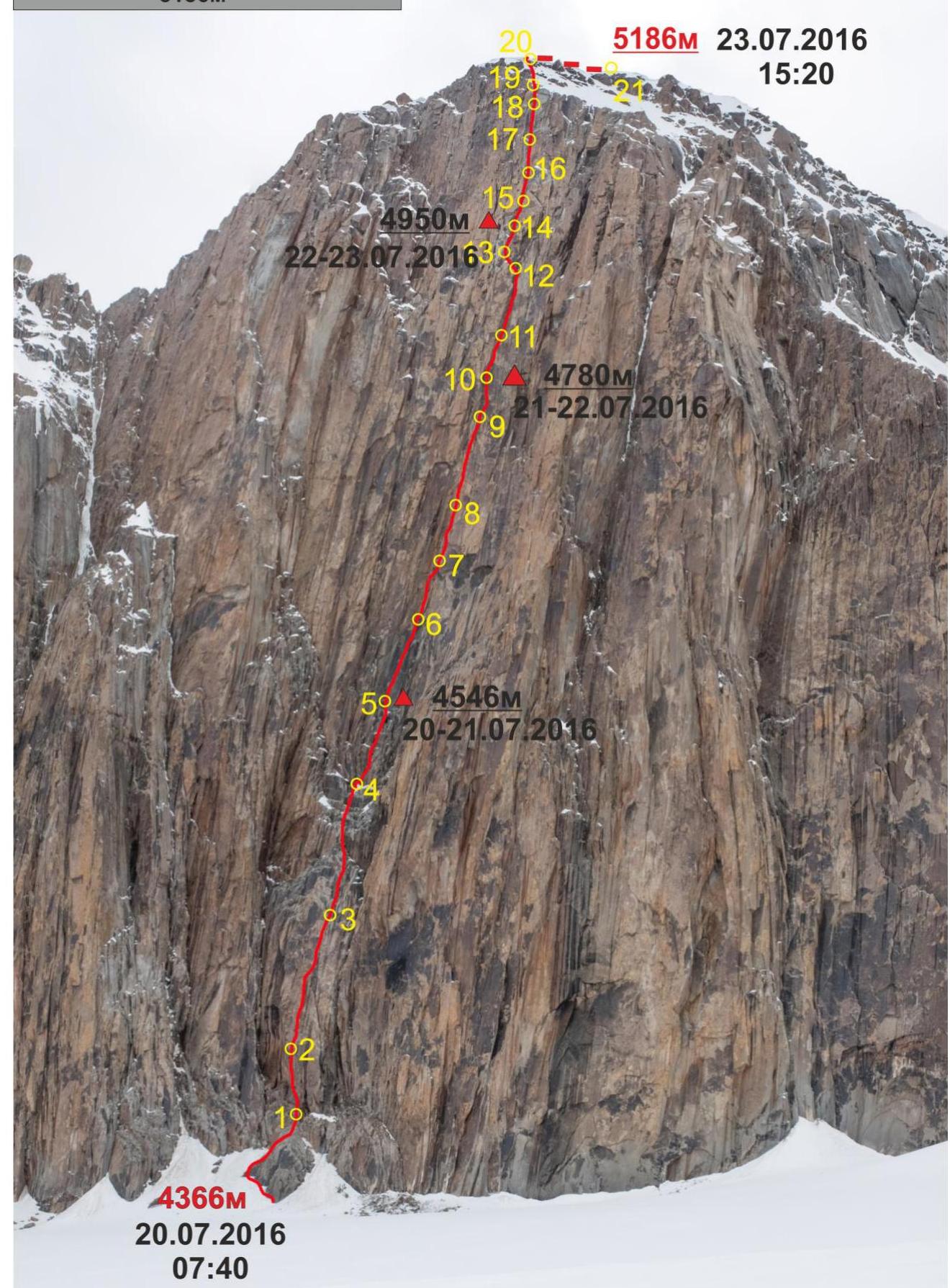
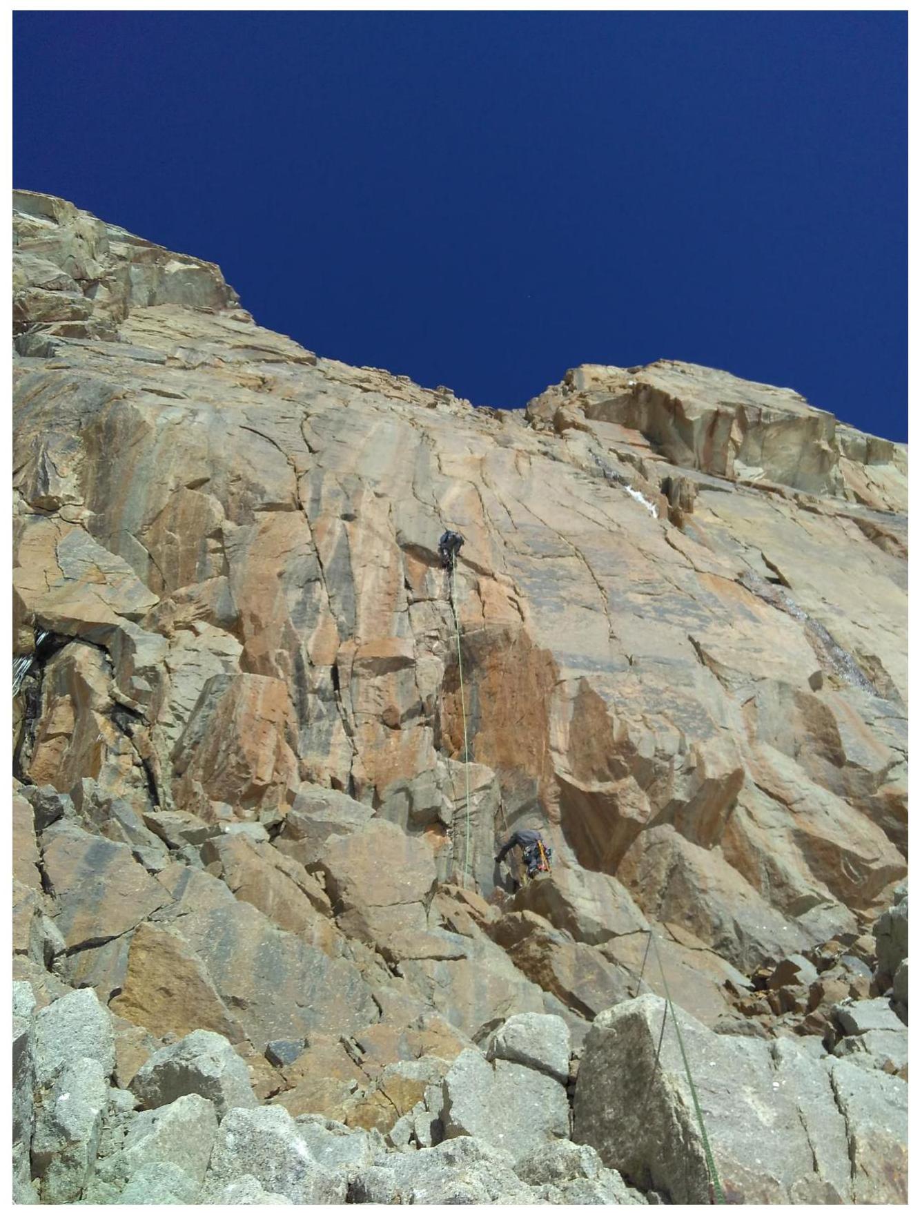 Photo 1. Passage of section R1–R2. Before the pendulum. O. Babushkina and V. Sysoev. Taken from section R0–R1.
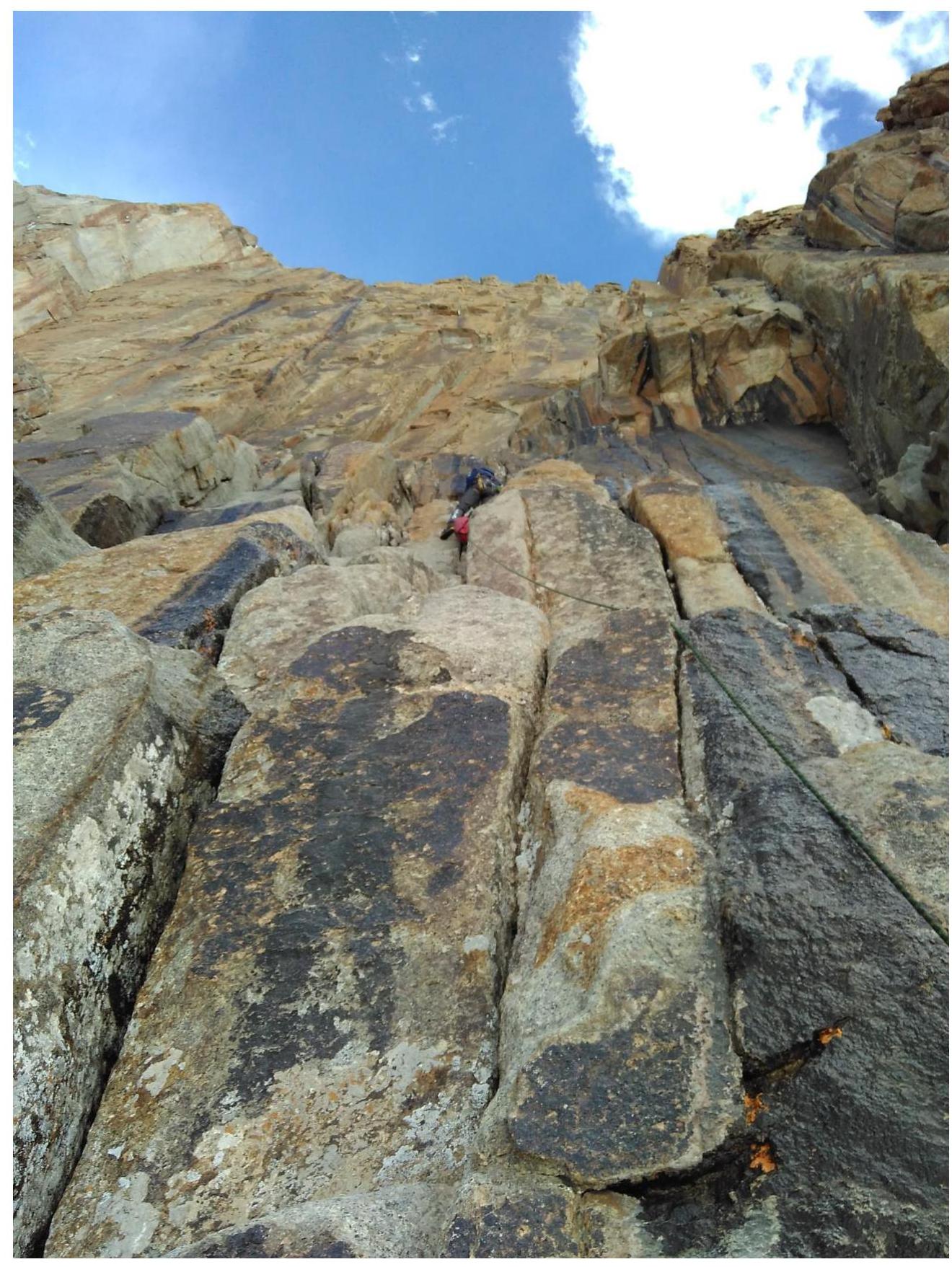 Photo 2. Passage of section R3–R4, with D. Prokofiev on the rope. Taken from station R3.
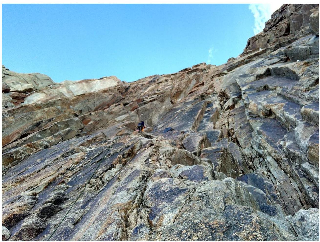 Photo 3. Passage of section R4–R5. Leader on station — bivouac July 20–21, 2016.
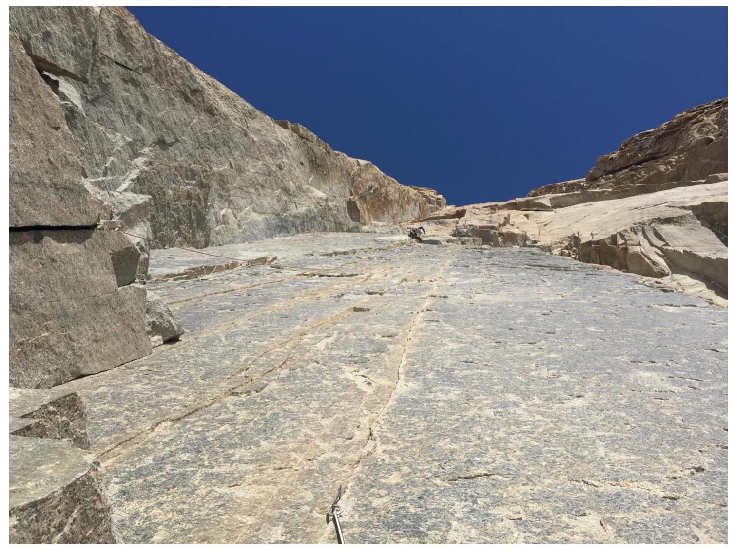 Photo 4. Main part of the wall. Section R5–R6. M. Popova approaching a series of cornices. On the left is a large overhanging internal angle along which the route passes.
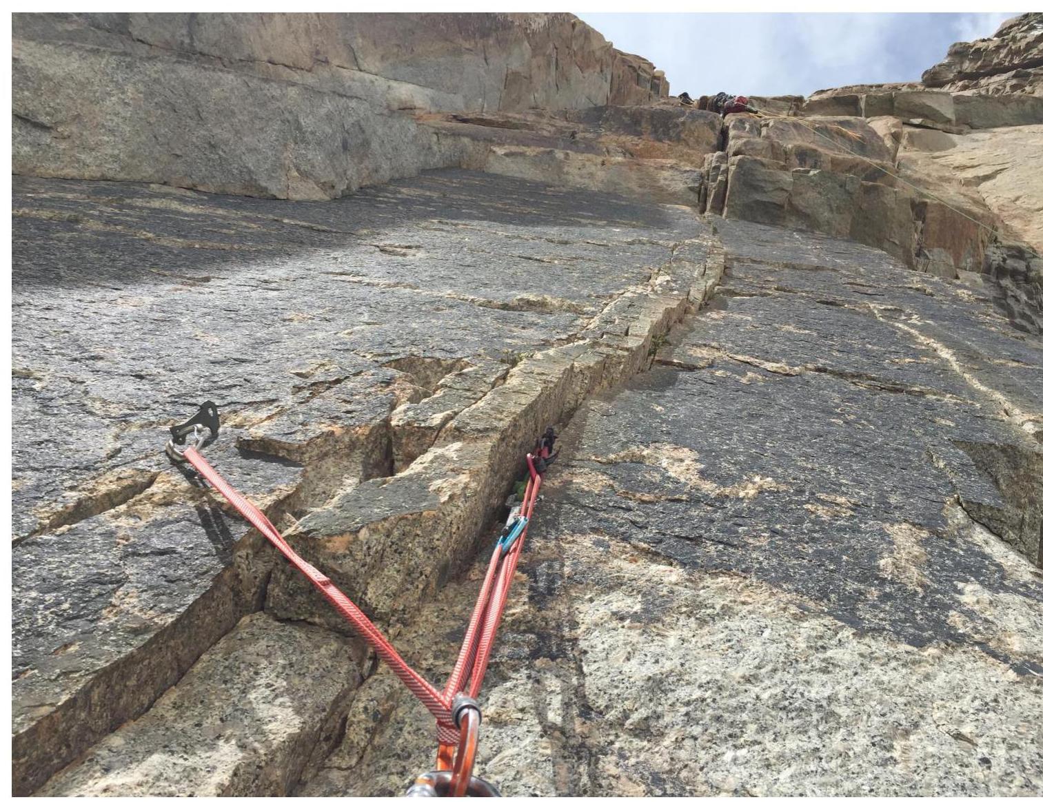 Photo 5. Main part of the wall. Section R6–R7. Cornices.
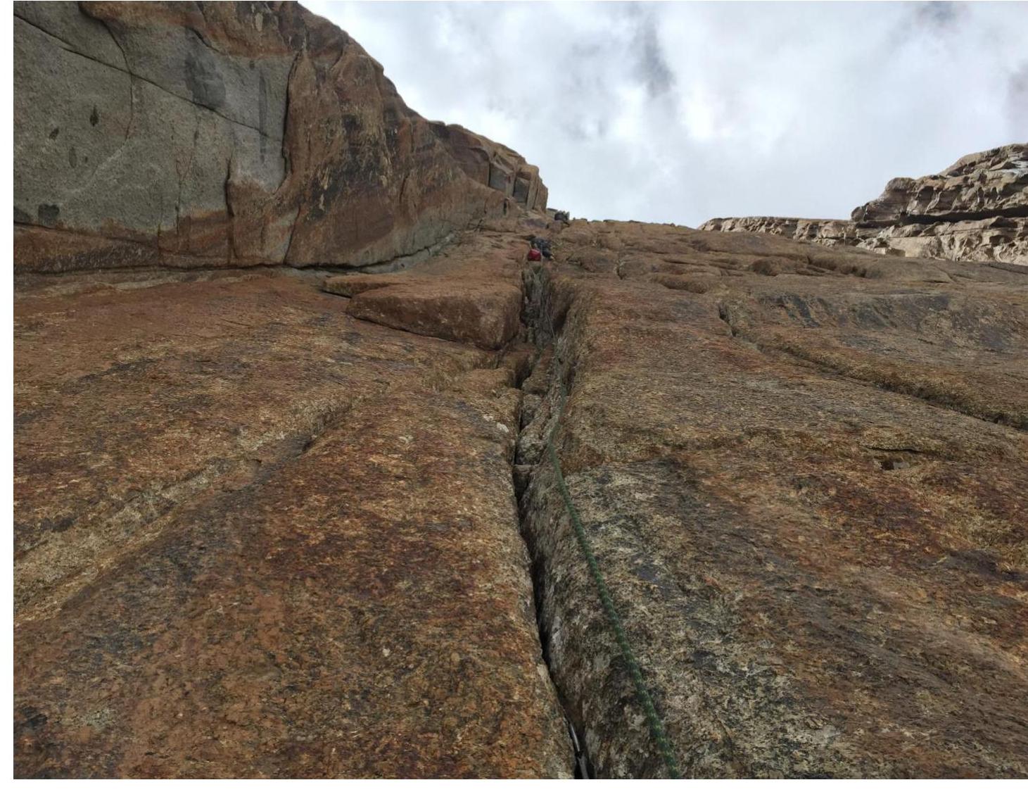 Photo 6. Main part of the wall. Section R7–R8. Vertical section with a series of small overhangs.
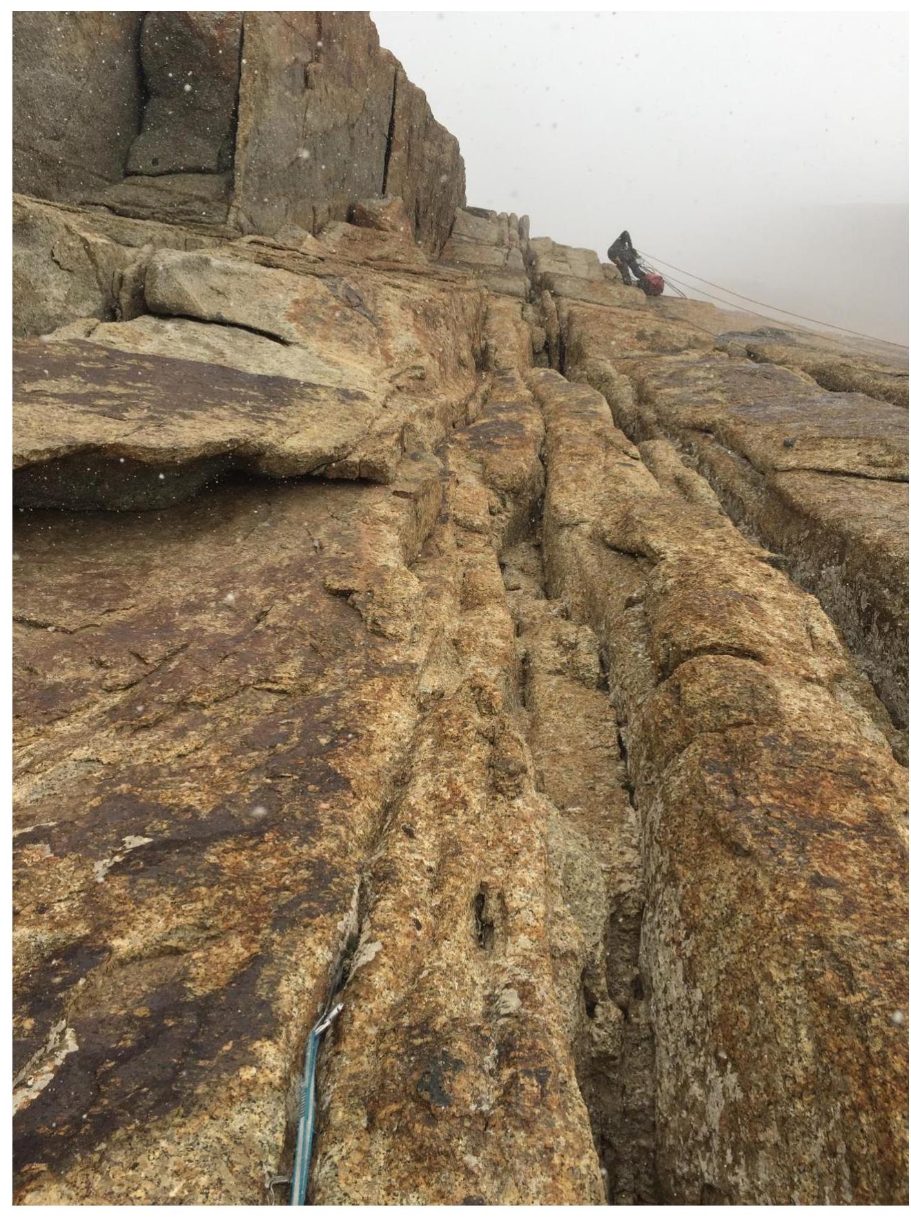 Photo 7. Main part of the wall. Section R8–R9. Approach to "feathers" and bypassing a cornice on the right via an overhang.
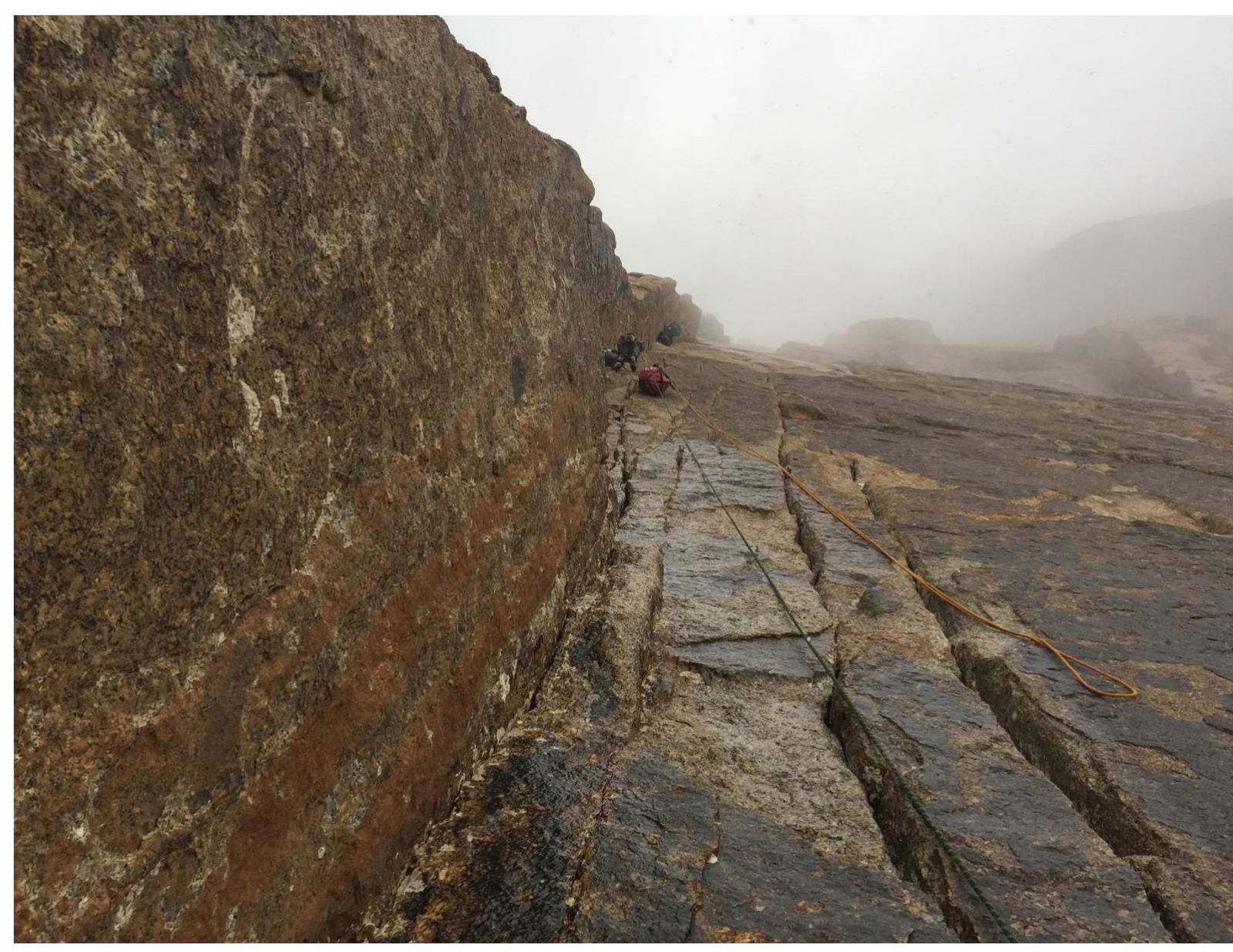 Photo 8. Main part of the wall. Work on section R10–R11.
 Photo 9. Bivouac site July 21–22. R10. Taken on July 22 in the morning before dismantling the platform and continuing up.
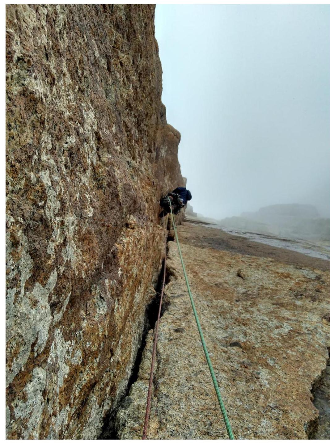 Photo 10. Large internal angle with an overhanging left wall, D. Prokofiev. Terrain is crumbling, R11–R12.
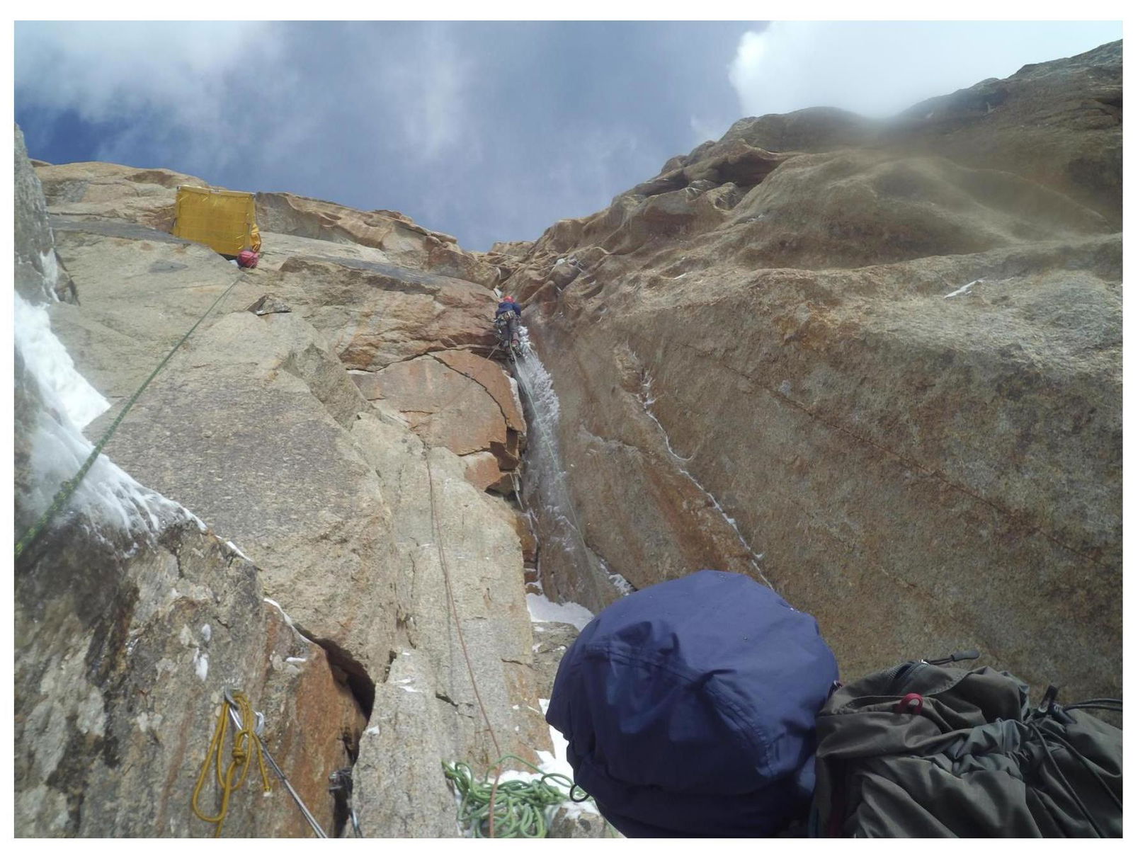 Photo 11. Approach to a chimney. R14–R15. On the left are the sites of two bivouacs: July 22–23 and July 23–24 (on descent).
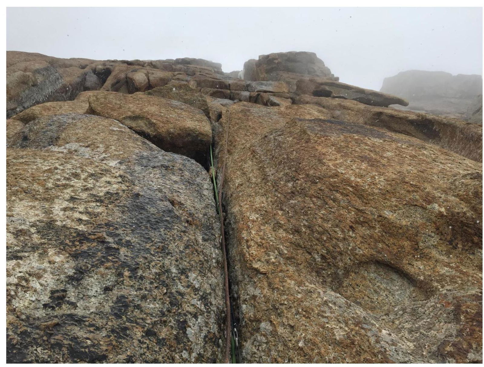 Photo 12. R16–R17. Vertical wall with wide cracks, partially overhanging.
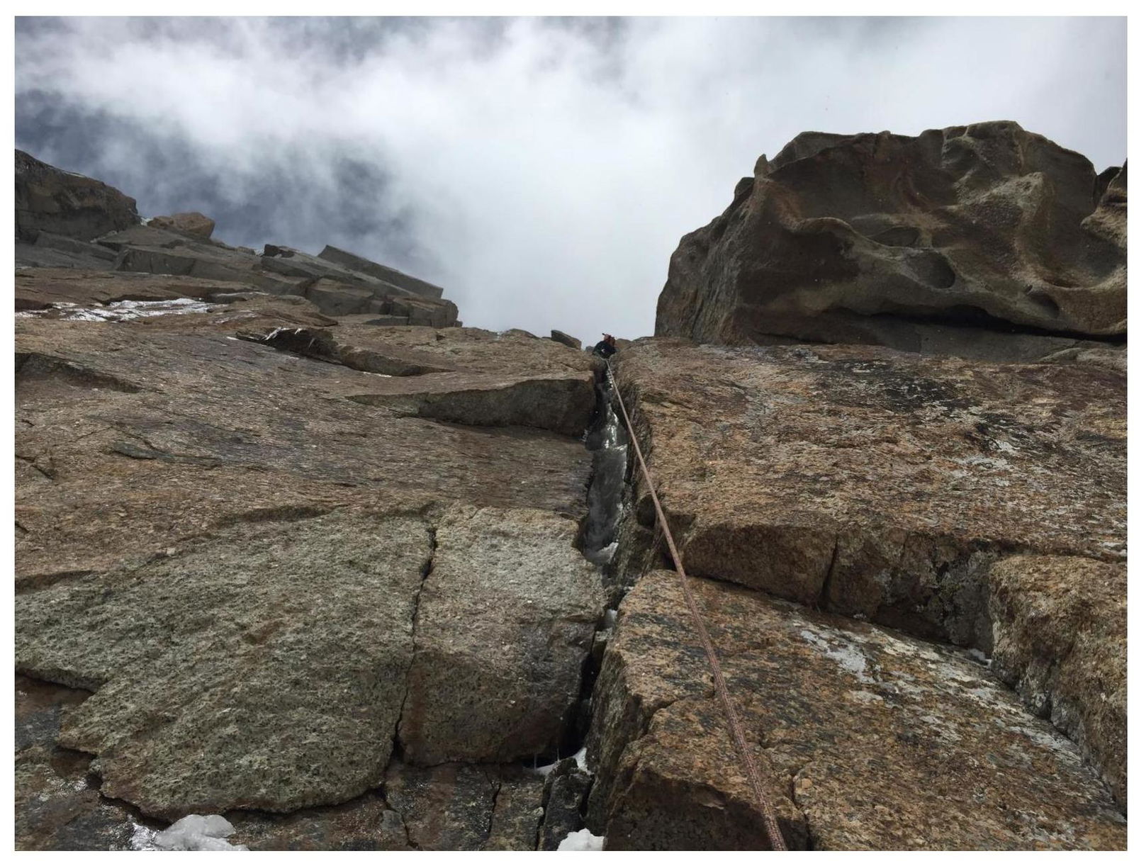 Photo 13. R17–R18. Wide cracks-chimneys. Terrain is unreliable and vertical.
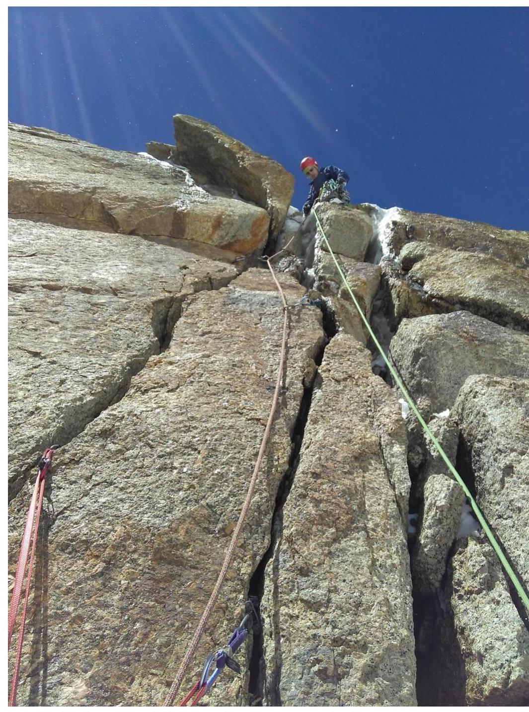 Photo 14. R18–R19. Section before exiting onto the snow-ice slope, D. Prokofiev.
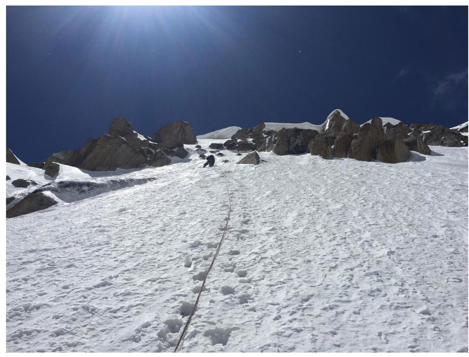 Photo 15. R19–R20. Snow-ice slope. Under a thin layer of snow — ice. Insurance with ice screws.
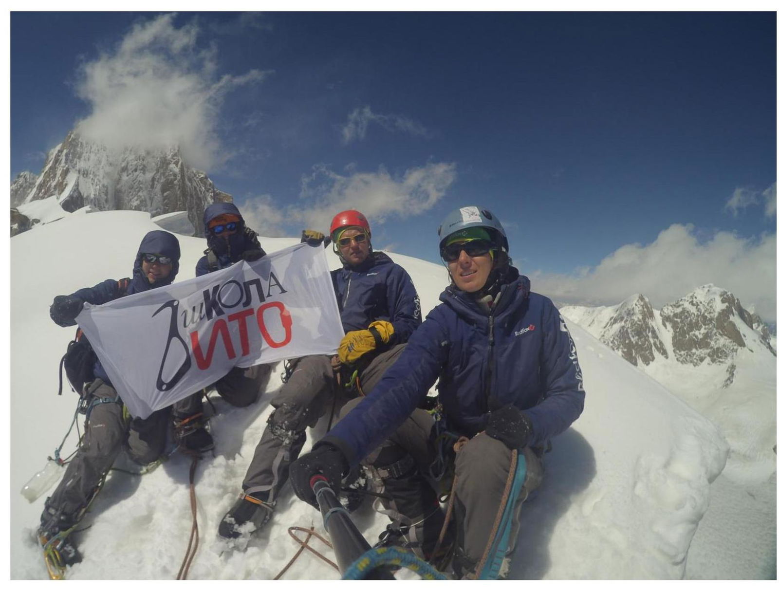 Photo 16. Summit photo. V. Sysoev, M. Popova, D. Prokofiev, O. Babushkina. In the background, Kyzyl-Asker Peak.