
Krasnodar Region Alpinism Federation
Russian Alpinism Championship
TECHNICAL AND ALTITUDE CLASS
Report
ON THE FIRST ASCENT TO THE SUMMIT OF PIK KOCHEVNIKOV 3460 m VIA THE CENTER OF THE NORTH-WEST WALL "STENA TENEY" (SHADOW WALL), ACCOMPLISHED BY THE TEAM OF RPO "Krasnodar Region Alpinism Federation"
presumably 6A category. FIRST ASCENT
Foygel M. R. Lange A. S. Sushko D. S.
2022
Table of Contents
Table of Contents — 2 Route Passport — 3 General Photo of the Summit — 5 Route Profile Photo — 6 Drawn Route Profile — 7 Area Panorama — 8 Area Map — 9 Ascent Schedule — 10 Information about the Ascent Object and Team Actions — 11 Recommended Equipment Set — 13 Route Diagram in UIAA Symbols — 14 Technical Photograph of the Route — 15 Route Description by Sections — 16 Descent from the Route — 18 Photographs of Route Sections — 19
Route Passport
| № | 1. General Information | |
|---|---|---|
| 1.1 | Team Leader | Foygel Maxim Rafailovich (CMS) |
| 1.2 | Participants | Lange Alexander Sergeevich (MS) Sushko Denis Sergeevich (MS) |
| 1.3 | Coach | – |
| 1.4 | Organization | RPO "Krasnodar Region Alpinism Federation" |
| 2. Characteristics of the Ascent Object | ||
| 2.1 | Region | Tian Shan, Kyrgyz Range |
| 2.2 | Valley | Upper Ala-Archa |
| 2.3 | Section Number | 7.4. |
| 2.4 | Summit | Pik Kochevnikov 3460 m (summit name given by the team) |
| 2.5 | Coordinates | 42.47996° N, 74.47557° E |
| 3. Route Characteristics | ||
| 3.1 | Route Name | via the center of the north-west wall "Stena Teney" (Shadow Wall) |
| 3.2 | Proposed Category | 6A |
| 3.3 | Region Exploration Level | first ascent |
| 3.4 | Terrain Character | rock |
| 3.5 | Height Difference | 410 m |
| 3.6 | Route Length | 505 m |
| 3.7 | Section Lengths | I cat. sl. — 75 m II cat. sl. — 90 m III cat. sl. — 55 m IV cat. sl. — 75 m V cat. sl. — 10 m VI cat. sl. and above — 60 m A1 — 45 m A2 — 100 m A3 — 5 m Descent rappel (on descent) 1 × 40 m |
| 3.8 | Average Route Steepness | 65° |
| 3.9 | Average Steepness of the Main Route Part | 70° |
| 3.10 | Descent from the Summit | Down to the Upper Ala-Archa valley via a non-classified route (see section "Descent from the Route") |
| 3.11 | Additional Route Characteristics | No water on the route |
| 4. Characteristics of Team Actions | ||
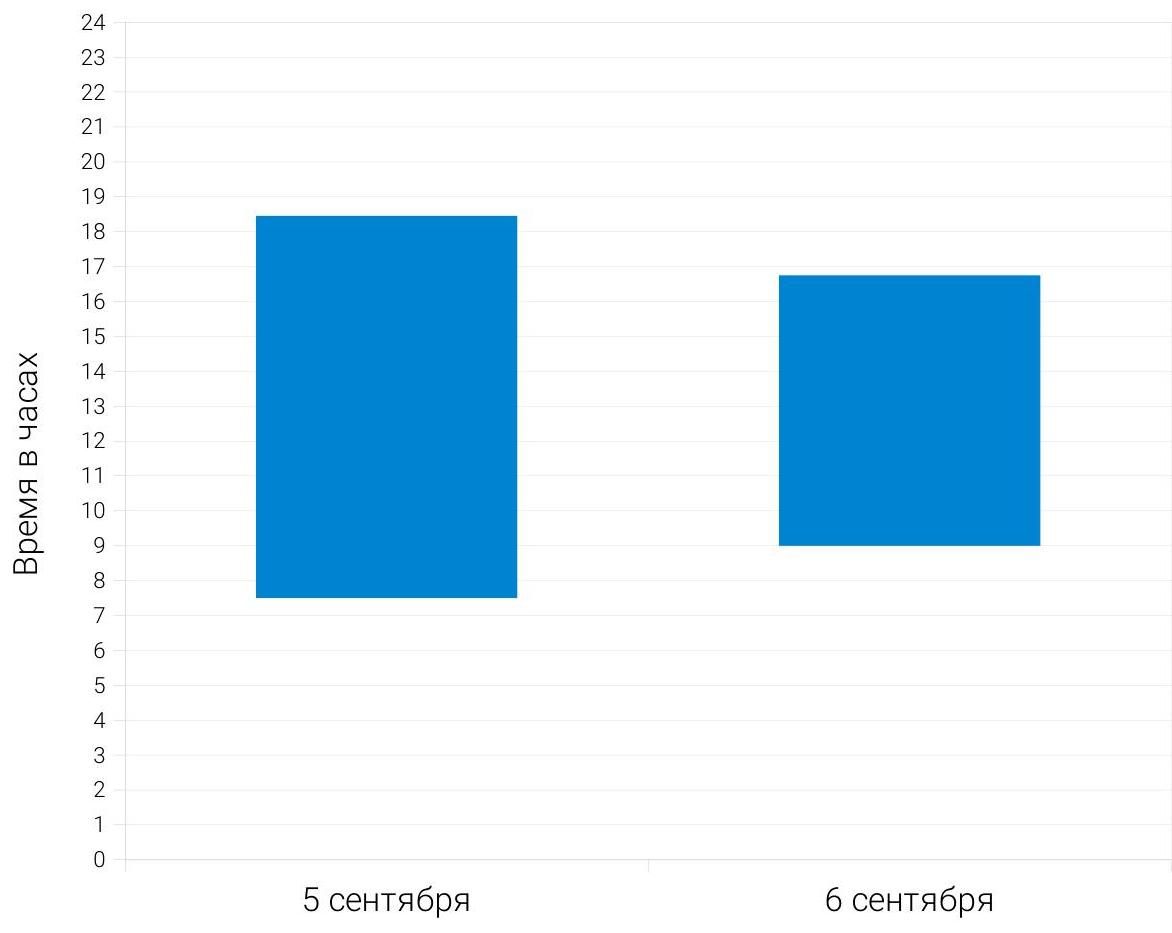
| 4.1 | Ascent Time | 19 h / 2 days |
| 4.2 | Overnight Stays | Bivouac under a sitting overnight stay |
| 4.4 | Route Preparation | – |
| 4.5 | Start of the Ascent | 7:30, September 5, 2022 |
| 4.6 | Summit Ascent | 16:45, September 6, 2022 |
| 4.7 | Return to Base Camp | 19:30, September 6, 2022 |
| 5. Weather Conditions Characteristics | ||
| 5.1 | Temperature, °C | – |
| 5.2 | Wind Speed, m/s | – |
| 5.3 | Precipitation | – |
| 5.4 | Visibility, m | – |
| 6. Report Author | ||
| 6.1 | Foygel Maxim Rafailovich, m.foygel@gmail.com, +491781818303 |
General Photo of the Summit
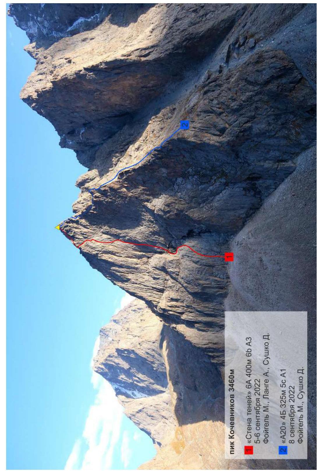
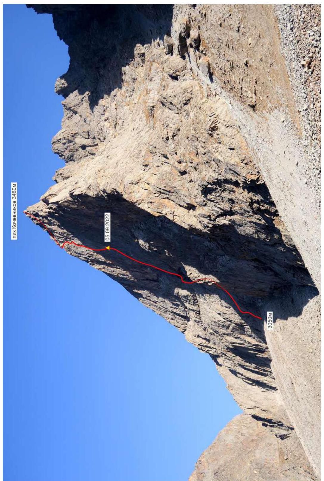
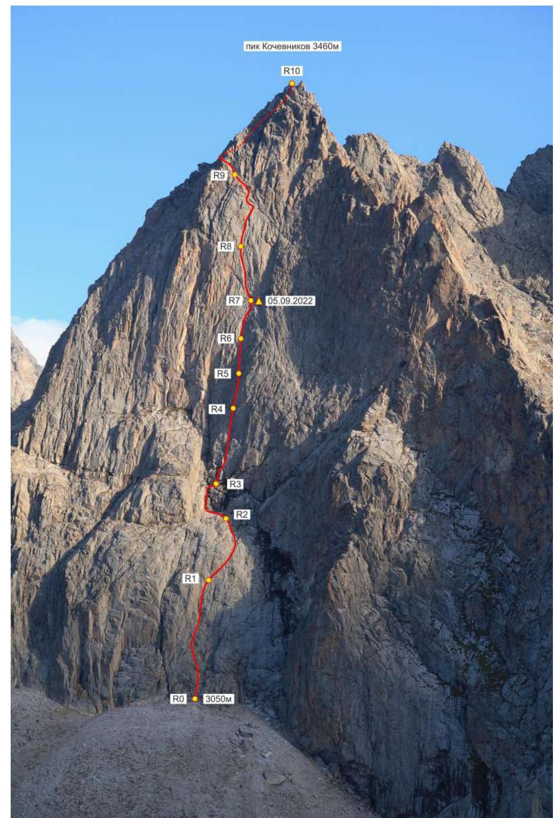
Route Profile Photo
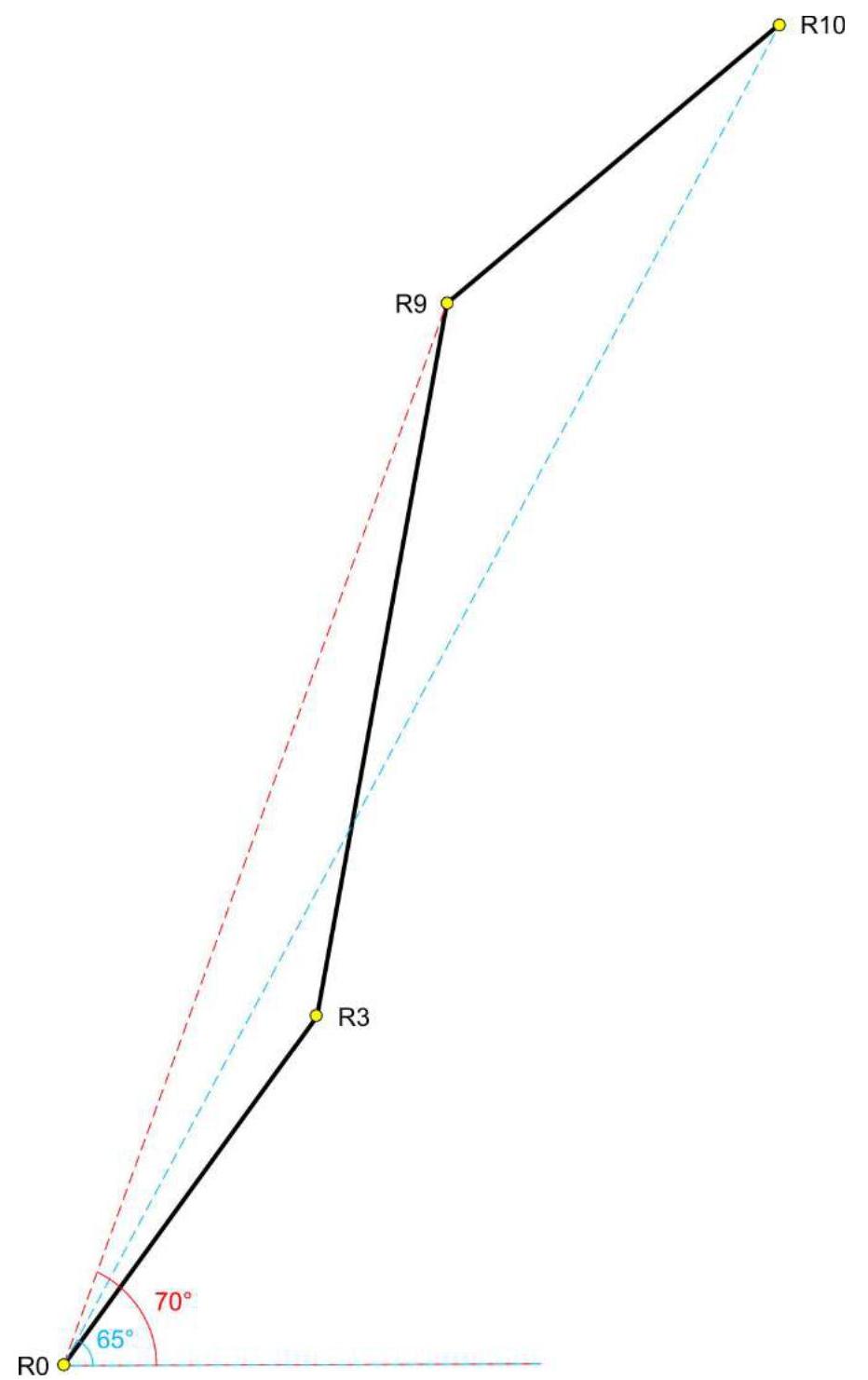
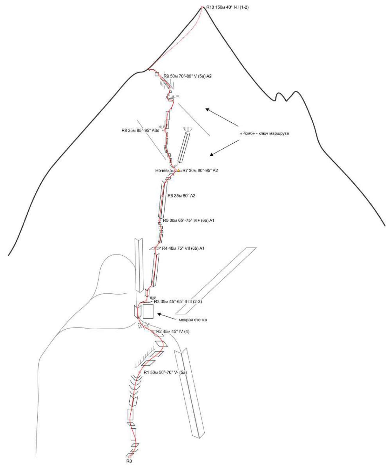
Drawn Route Profile
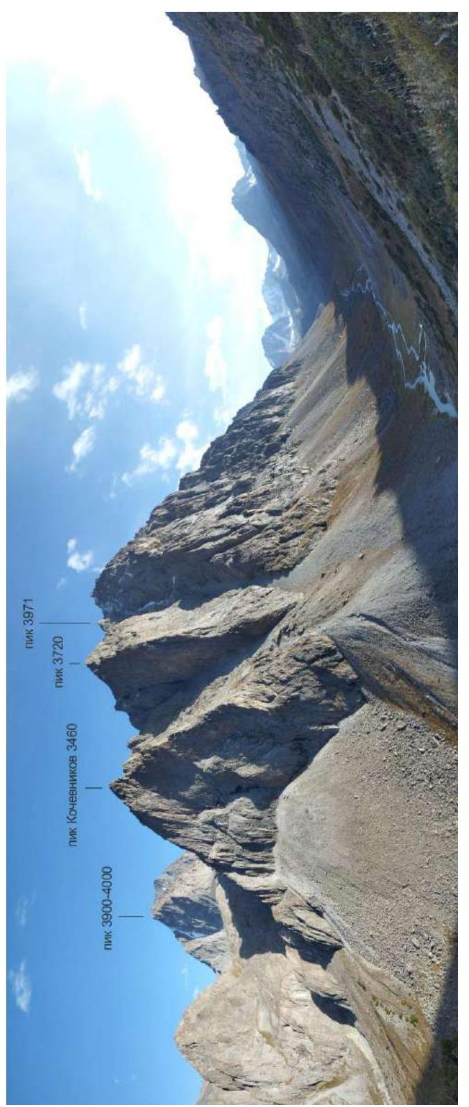
Area Panorama
Area Map
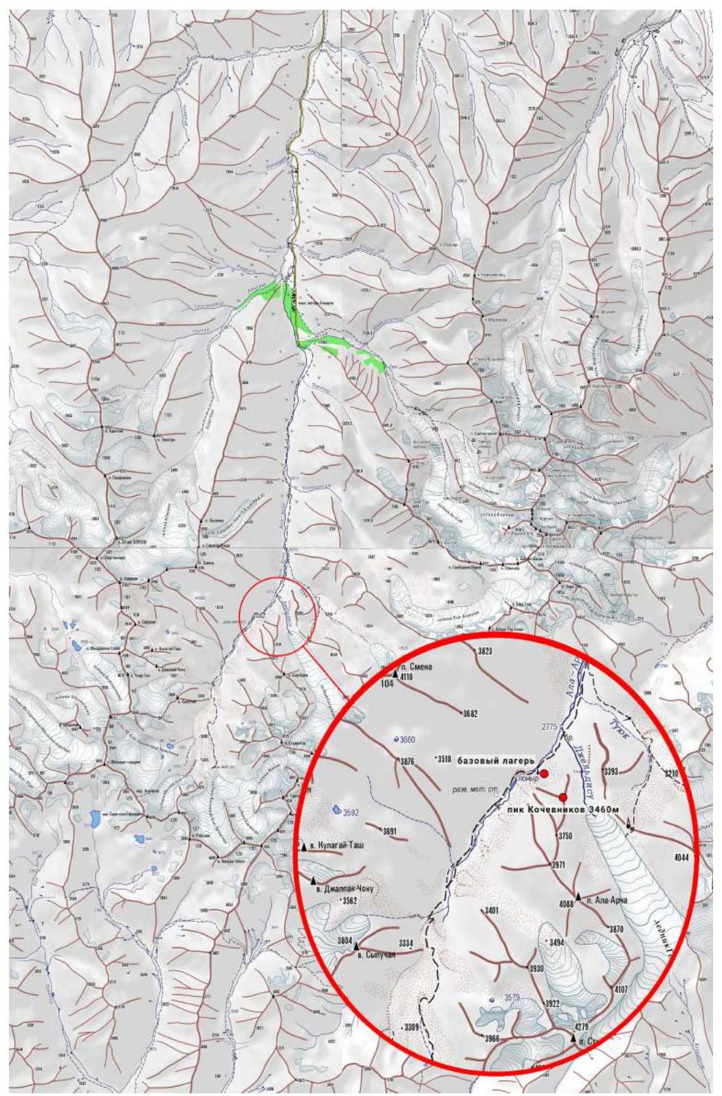
Area map compiled by Alexander Purikov. Original taken from www.westra.ru ↗
Ascent Schedule
Information about the Ascent Object and Team Actions
The Upper Ala-Archa region is part of the Ala-Archa National Park, known for its popular alpinism area. Although these two areas are relatively close to each other, Upper Ala-Archa is visited much less frequently, mainly by mountain tourists and rarely by climbers.
In the past, during the USSR era, simple routes were laid out to the main summits. The lack of "big walls" likely influenced the area's further development, as climbing here did not promise high places in alpinism championships.
Despite this, the Upper Ala-Archa area remains interesting for climbers of various levels. Besides existing training routes, it's possible to create several interesting sport routes on walls and ridges to summits up to 4000 m. Simple logistics allow for quick access to base camp locations.
This is facilitated by:
- Presence of suitable walls and ridges for sport routes
- Summit heights up to 4000 m
- Simple logistics
- Quick access to base camp locations
In April 2021, part of our team (Foygel, Lange) visited the Upper Ala-Archa area. On approach, we were drawn to the spurs of Pik Ala-Archa, specifically the NW wall of an unnamed summit.
Over the following months, we gathered information on this area, consulted with local climbers, and studied existing routes. We found that the object of our interest had no name or recorded ascent attempts.
In early September 2022, our team consisting of Maxim Foygel (leader), Alexander Lange, and Denis Sushko gathered in Bishkek. On September 2, 2022, we conducted a detailed reconnaissance and planned the ascent route. On September 4, 2022, we moved from Bishkek and set up base camp near the ascent object.
Despite the relatively small height difference, it was clear that the NW wall had a steep terrain and would require maximum effort. We planned for one overnight stay but had a sufficient supply of provisions and gas for a possible second night.
Additionally, we had to carry a sufficient water supply for 3 days since there's no token of water on the route.
Preferring a maximally sporty style, we avoided processing the lower part of the route. On September 5, 2022, we started from base camp. The approach took about 30 minutes.
The first part forms the base of the wall, consisting of compact rocks with limited relief and scarce protection opportunities.
The main part of the route follows — the wall itself. We chose the most direct line, following a series of internal corners stretching from the base to the upper third of the wall.
The terrain is steep, with mostly blind cracks, so we primarily used pitons. The first two ropes (R3–R5) were mostly free-climbed. As the terrain steepened, the next two ropes (R5–R7) were largely done on artificial aids (AID).
Approaching the upper part, dubbed the "Rhombus" for its resemblance, we found a small ledge — the only viable spot for an overnight stay. We expanded the area and set up a somewhat comfortable sitting bivouac, securing it with a bolt hanger for safety. We left a note (control cairn) there.
The next day, we resumed the ascent. The first rope (R7–R8) from the bivouac proved to be the most challenging on the entire route. From the station, we had to overcome broken, overhanging rocks, followed by difficult AID on blind cracks.
About halfway through this section, we placed another bolt hanger as the cracks ran out, and we had to make several moves on skyhooks. The smooth slab lacked relief, leaving no choice but to:
- Drill 3 holes for skyhooks.
Further on, we could again use pitons.
The next rope (R8–R9), though easier than the previous, still required significant AID.
The final part, "The Roof," consists of relatively simple rocks.
On the summit, we built a control cairn and left a note. The descent from the summit to the west was technically straightforward, with only one rappel. The weather remained good and warm throughout the ascent.
After a rest day, the duo Foygel–Sushko made another ascent of the same summit via the 3rd ridge. A separate report will be submitted for this ascent. As we were likely the first climbers to reach the summit, we decided to name it Pik Kochevnikov. The approximate summit height by GPS is 3460 m. Coordinates: 42.47996° N, 74.47557° E.
The route can be characterized as technically challenging, corresponding to our assessment of 6A category. The relatively short length is compensated by the steep terrain. To tackle this route, one needs:
- A wide range of equipment
- Significant climbing experience
- Proficiency in AID climbing
Recommended Equipment Set
The recommended equipment is for a two-person team:
- Rope 2 × 50 m
- Cams 1.5 set (10–12 pcs.) from small to large sizes
- Stoppers 6–8 pcs. from small to medium sizes
- Pitons 12–15 pcs.
- Skyhooks for drilled holes 2 pcs.
- Slings (quickdraws) 60 cm (with carabiners) 15 pcs.
- Station slings 180 cm 2 pcs.
- Carabiner set for equipment hanging and belay station backup
- Rock hammer 2 pcs.
Several stations are recommended to be reinforced with bolt hangers, especially:
- R1
- R3
- R4
- R5
This requires a drill and 5–6 bolt hangers.
It's likely that subsequent ascents will require less time, potentially avoiding the overnight stay on the wall. However, we believe passing the route without a bivouac is extremely challenging. Even if the wall section is completed in daylight, a bivouac might still be necessary on the R9–R10 section. Thus, bivouac gear and water should also be included in the equipment.
Route Diagram in UIAA Symbols
Technical Photograph of the Route
Route Description by Sections
R0–R1 50 m 50°–70° V– (5a)
Up simple rocks (III). Then up-left through a series of slabs to an internal corner-gully (IV+). Up this to under a steep rock belt (V–). Station on pitons here.
R1–R2 50 m 45° IV (4)
From the station, up-right along the steep rock belt to a ledge. Then up through "bald heads" to the right edge of a large terrace. Station under a yellow-colored overhanging rock.
R2–R3 35 m 45°–65° II–III (2–3)
Enter the terrace, approach the wet wall, bypass it via a ruined internal corner on the left, and exit to a sloping ledge above. Station under a small internal corner with a wet left wall and a right wall formed by a small overhang.
R3–R4 40 m 75° VII (6Б) A1
From the station, up through an internal corner with loose blocks to its end (VI). Move right from this corner, past a bend, to a series of small internal corners following each other. Up these to a small ledge. Climbing through corners ranges from VI+ to VII with short AID sections (A1).
R4–R5 30 m 65°–75° VI+ (6А) A1
From the station, slightly right to an internal corner. Up this to a flattening (A1). Then up-left through slabs to the base of the next internal corner (VI). Station on pitons here.
R5–R6 35 m 80° А2
Up the corner to where the rocks on the right wall have a reddish color. Here, under the red patch, a reliable station can be made on cams and pitons.
R6–R7 30 m 80°–95° А2
Further up the corner with a convenient crack for small cams (A1). Then up the corner with blind cracks to a small overhang (A2). Traverse it (A2) and exit to a flattening. From here, up-right to a ledge under an overhang (III). Station on a bolt hanger and pitons.
Here we set up a bivouac. Space for three people for a sitting overnight stay. For added safety, we placed a bolt hanger.
R7–R8 35 m 85°–95° A3e
From the station, left-up through an overhang to a system of walls with blind cracks (A2). Up these to a small internal corner (A2). Up this to a bolt hanger (A2). From the bolt, three moves on skyhooks to a blind crack (A3). Then up-right through it to an internal corner (A2). Up this to its end (A2). The corner then turns into a small chimney. Up the chimney to a small ledge under a cornice (VI–). Station here.
R8–R9 50 m 70°–80° V (5a) A2
From the station on the ledge, up to a characteristic crack, then up through it to its end (A2). Further on are gray walls with blind cracks. Up these until the cracks end (A2). Then climb up-right to a small rock rib. Up this to under a steep, reddish-colored rock belt (IV+). From here, traverse left to a small flake (A2). From it, climb up-left to a large rubble ledge-gully (V). Up this to under the north ridge of the summit, where a station can be made.
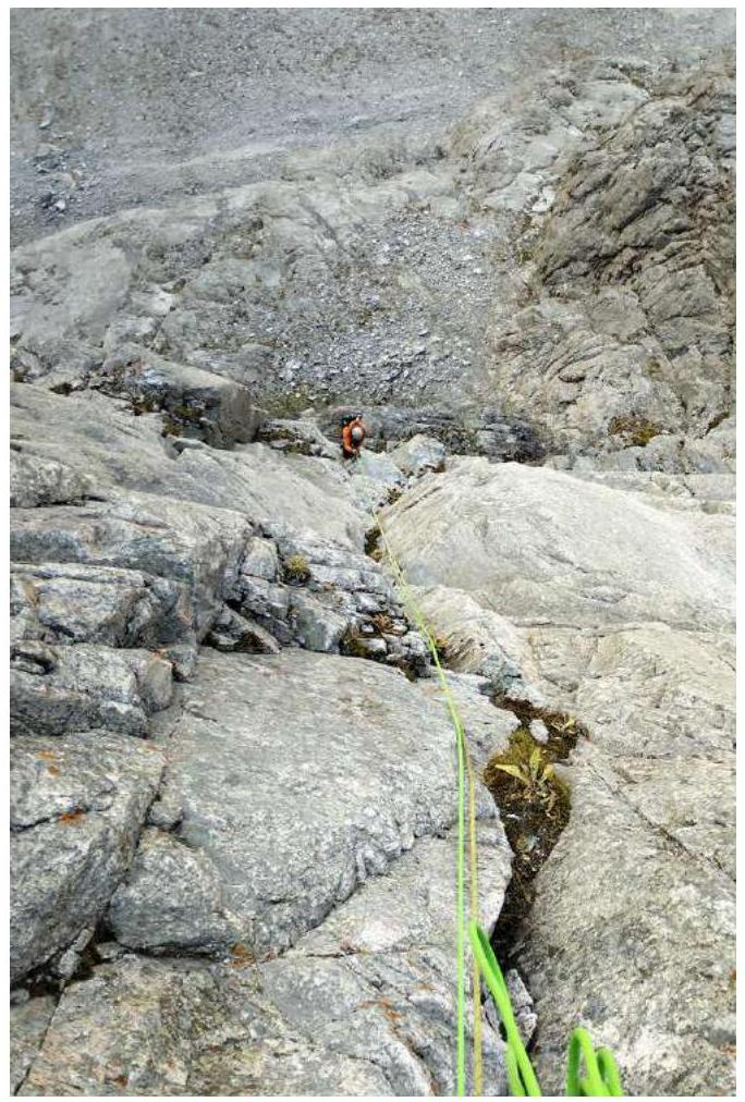
R9–R10 150 m 40° II (1–2)
Then across ledges and short walls, move to the eastern side of the ridge. From here, up along the ridge to reach the pre-summit shoulder and exit to the summit.
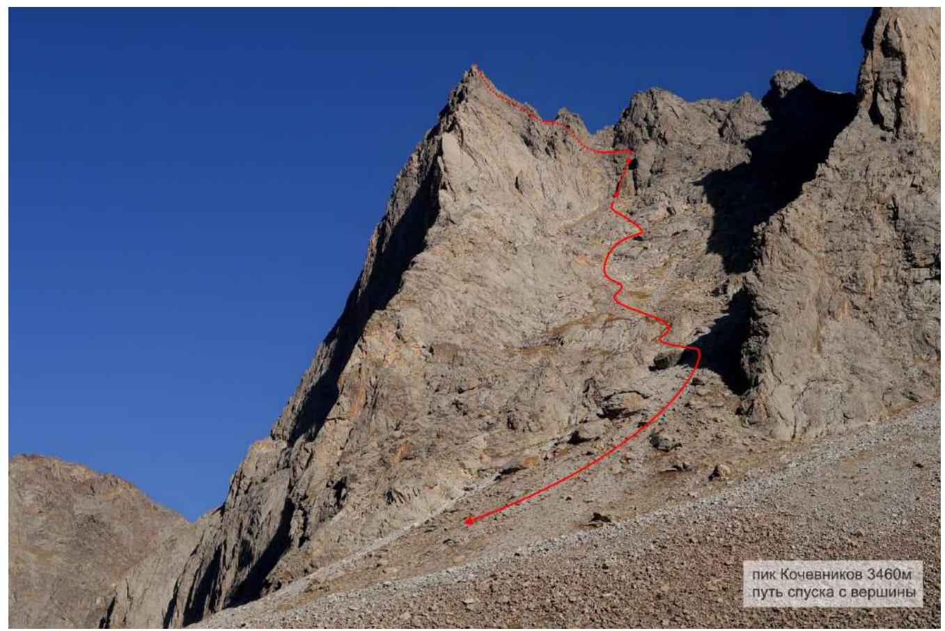
Descent from the Route
The descent from the summit is straightforward. Except for one rappel (40 m), everything can be descended on foot. Only a couple of places require careful navigation down "bald heads" with some climbing.
From the summit, follow the simple ridge southward to the first "gendarme." Bypass it on the left and begin descending from the saddle behind it down scree slopes to the southwest. Descend to a large terrace, just above the rock belt obstructing further descent. Move to its left part (relative to the descent direction) to a rappel anchor on a large ledge. The path to the anchor is marked by cairns.
From here, rappel 40 m to the scree slope. Then walk down scree slopes, interrupted by outcrops of "bald heads" (climbing sections 1–2), until reaching the trail by the river.
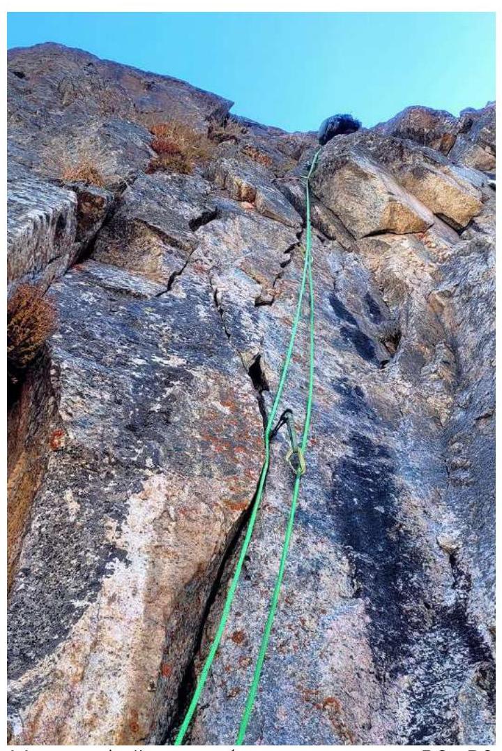
Photographs of Route Sections
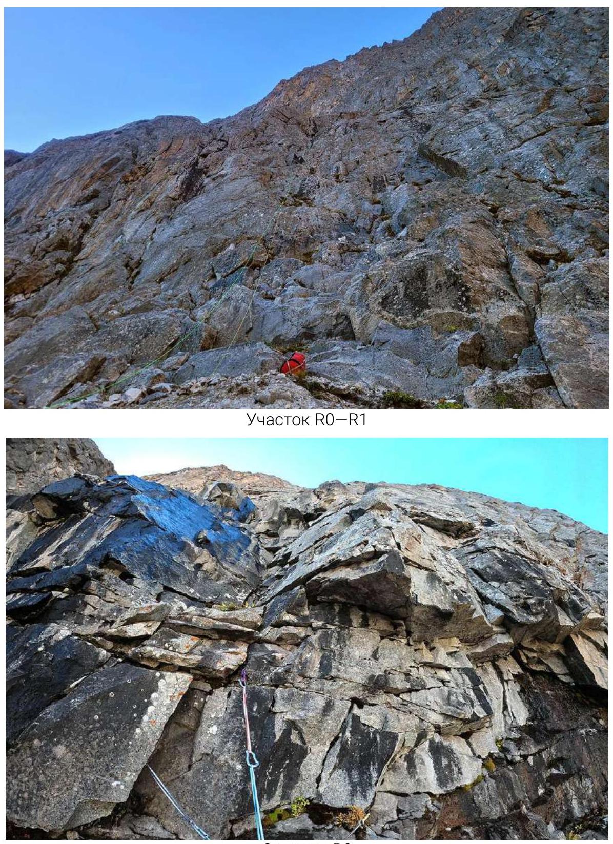
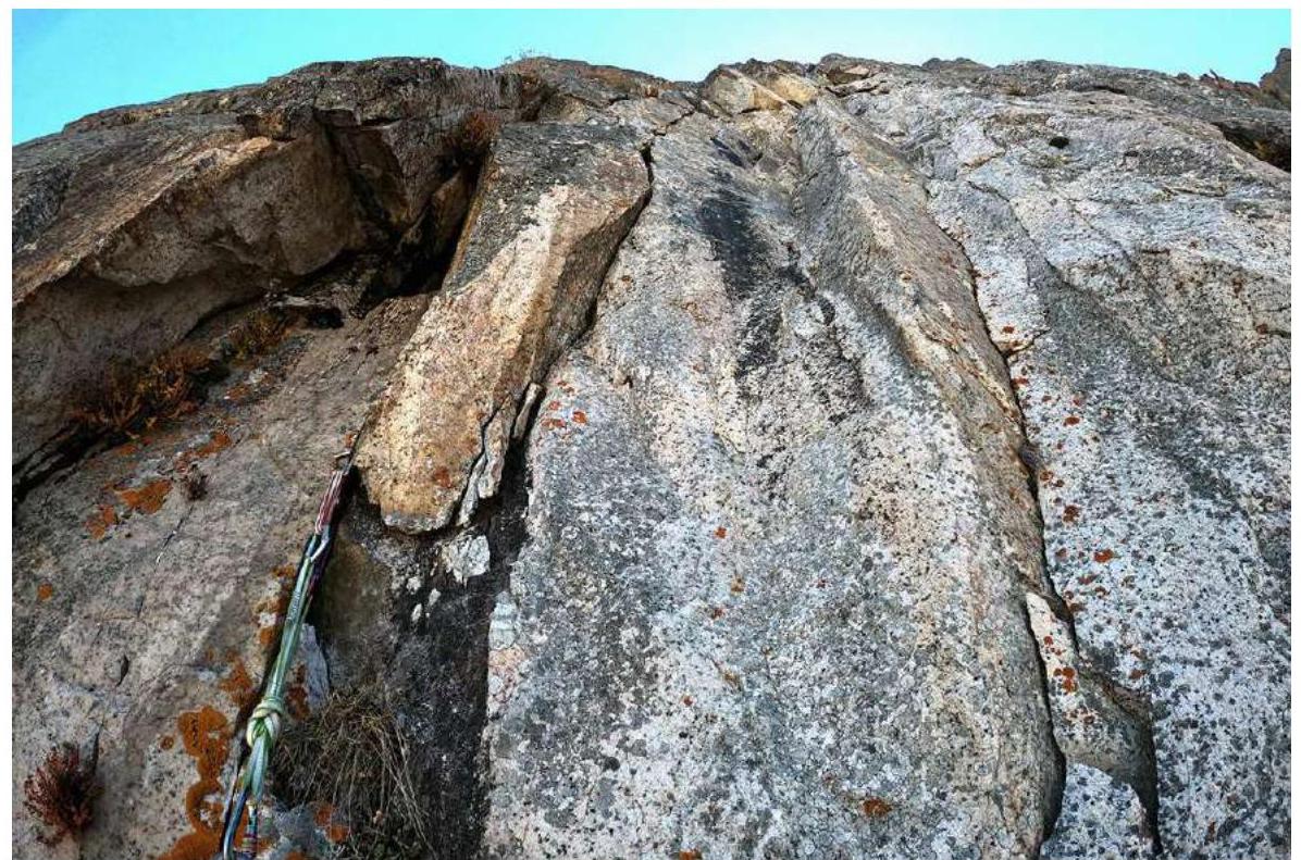
Section R0–R1
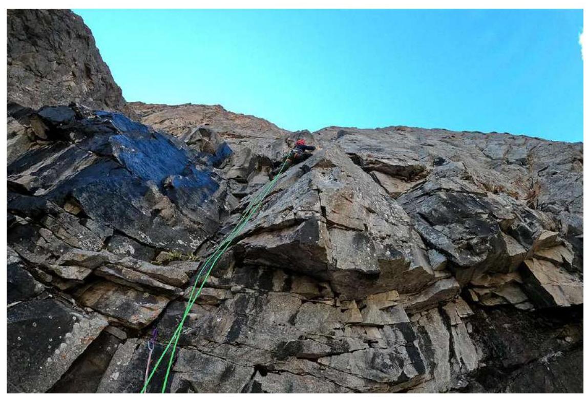
Denis Sushko on section R3–R4
Alexander Lange rappelling on section R3–R4
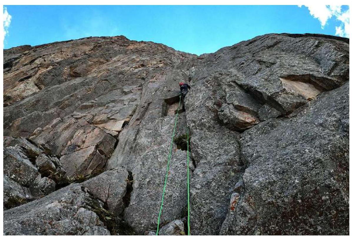
Denis Sushko on section R4–R5
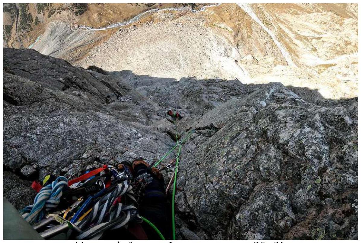
Maxim Foygel working on section R5–R6, Denis Sushko and Alexander Lange at station R5
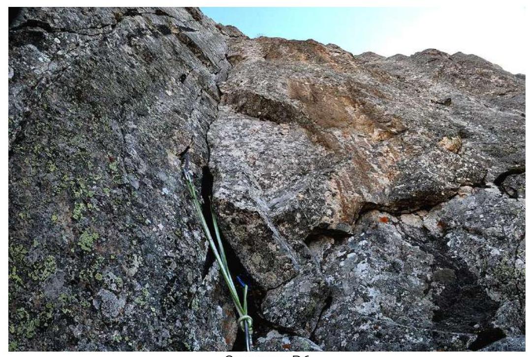
Station R6
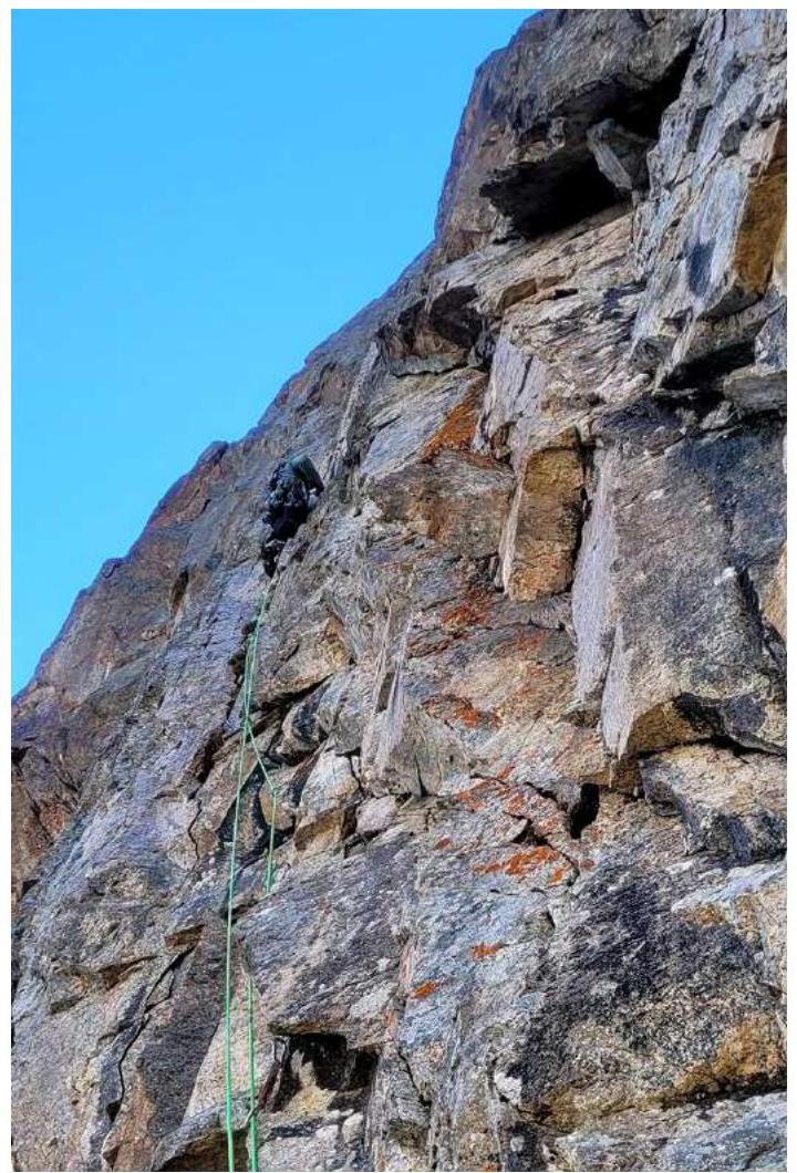
Maxim Foygel working on section R6–R7
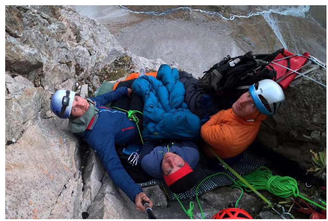
Sitting bivouac at station R7
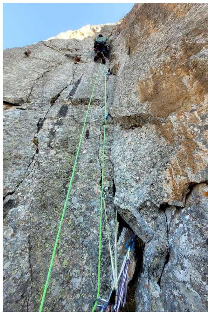
Maxim Foygel working on section R7–R8
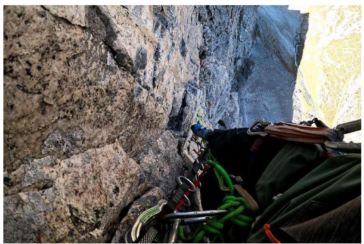
Maxim Foygel working on section R7–R8, Denis Sushko and Alexander Lange at station R7
Station R8
Maxim Foygel working on section R8–R9
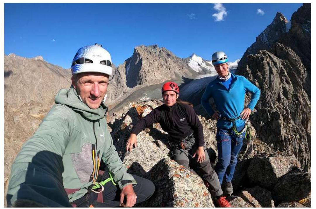
On the summit, from left to right: Maxim Foygel, Denis Sushko, Alexander Lange
Comments
Sign in to leave a comment