Ascent Passport
-
Class: ice-snow
-
Central Tian Shan, South Inylchek Glacier
-
Peak 5581 (p. Dobrovol'skogo) via the right part of the North face
-
Proposed — 6B category of difficulty, first ascent
-
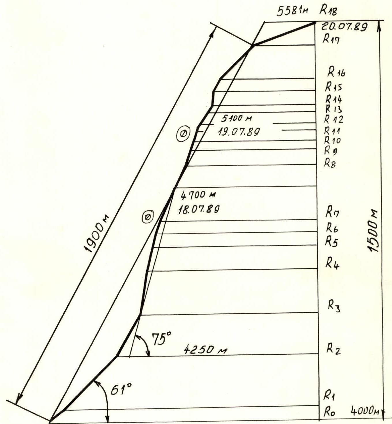
Elevation gain: 1500 m, route length — 2200 m.
Length of sections with 5–6 category of difficulty — 1200 m. Average steepness of the main sections is 75° (4250–5000), including 540 m of 6 category of difficulty.
-
Pitons used:
| Rock | Bolt | Chocks | Ice |
|---|---|---|---|
| 40 | 0 | 10 | 275 |
| 0 | 0 | 0 | 0 |
-
Team's total climbing hours: 32, and days — 3.
-
Overnights:
- 1st — semi-reclined in a tent. Platform carved in ice on a buttress.
- 2nd — sitting in a cave. Cave dug in a snowdrift on a buttress.
-
Leader: Vladimir Aleksandrovich Vareykis — Master of Sports of the USSR
Participants:
- Mikhail Vasil'evich Zagirnyak — Master of Sports of the USSR
- Vladimir Ivanovich Solov'ev — Candidate Master of Sports
- Andrey Aleksandrovich Moskalev — Candidate Master of Sports
- Vladimir Ivanovich Oleynik — Candidate Master of Sports
- Pavel Mikhailovich Zavershinskiy — Candidate Master of Sports
-
Coach: Mikhail Vasil'evich Zagirnyak — Master of Sports of the USSR, 1st sports category
-
Departure to the route: July 18, 1989.
Summit: July 20, 1989. Return: July 21, 1989.
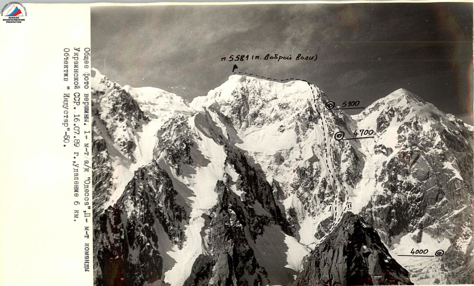
General photo of the summit. I — route of the team from ak "Odessa", II — route of the team from Ukrainian SSR. July 16, 1989. Distance 6 km. Lens "Industar"-50.
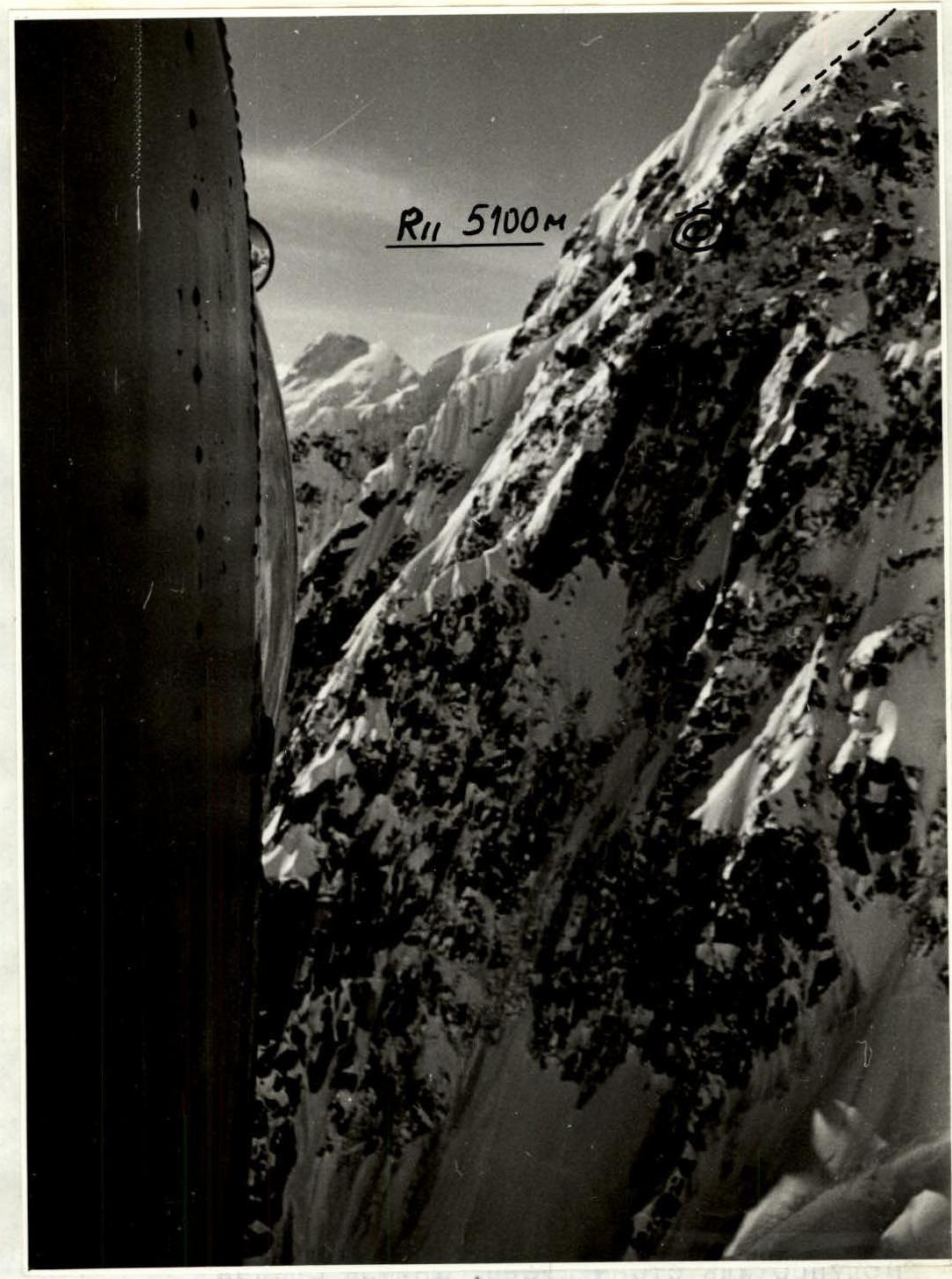
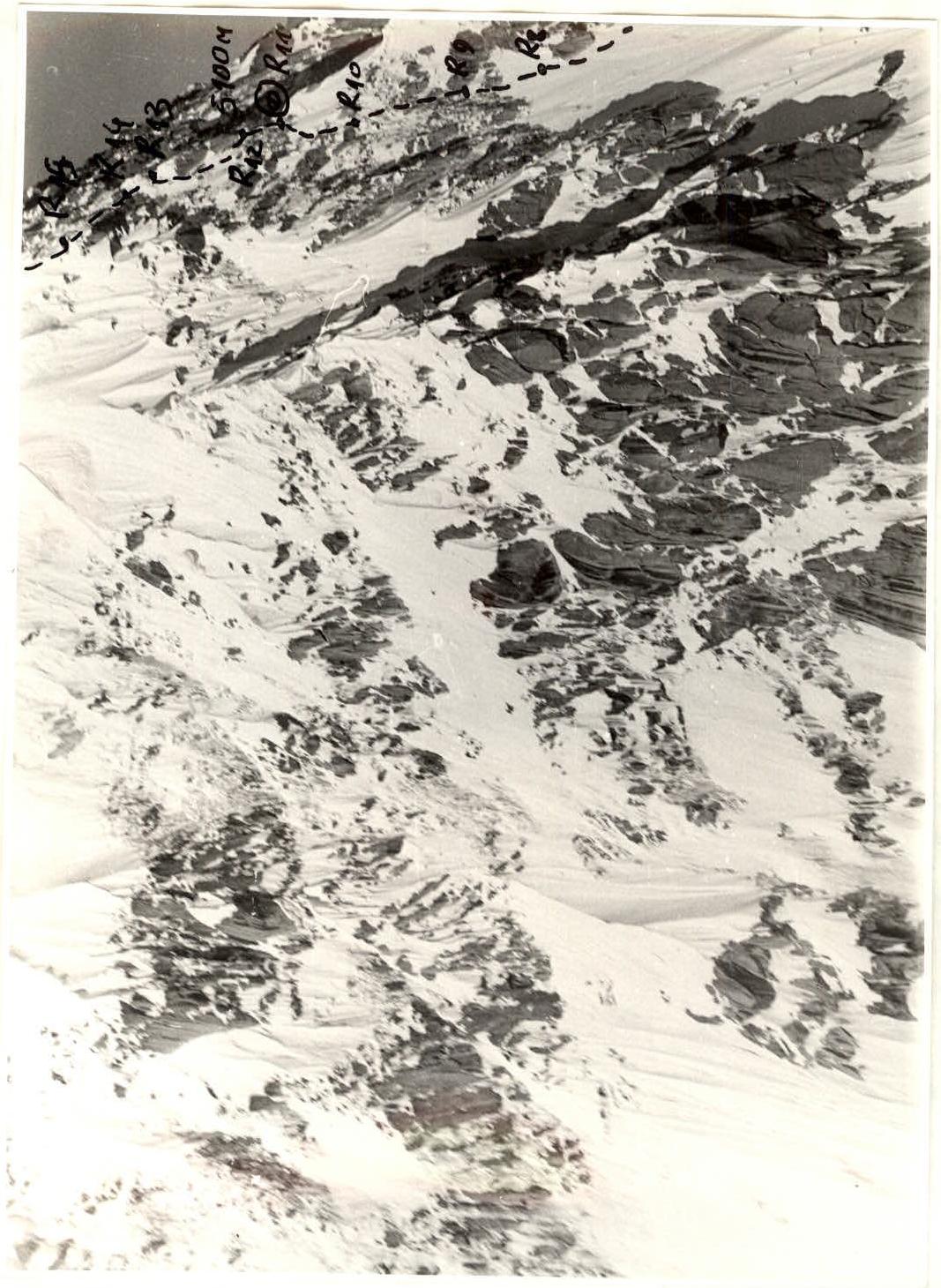
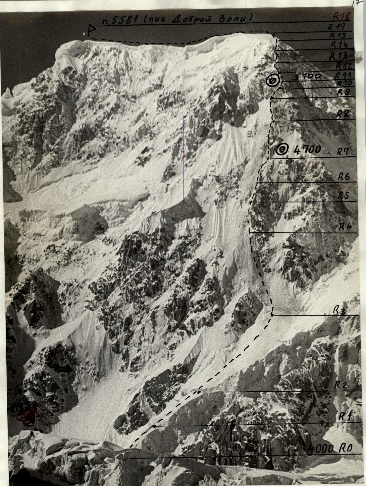
Profile of the wall from the right (upper part). Photo taken from a helicopter, distance 1 km. August 21, 1989. Lens "Industar"-50.
Semi-profile of the wall from the left. Photo taken from a helicopter. Distance 1.5 km. August 21, 1989. Lens "Industar"-50.
Hand-drawn profile of the route M 1:10 000
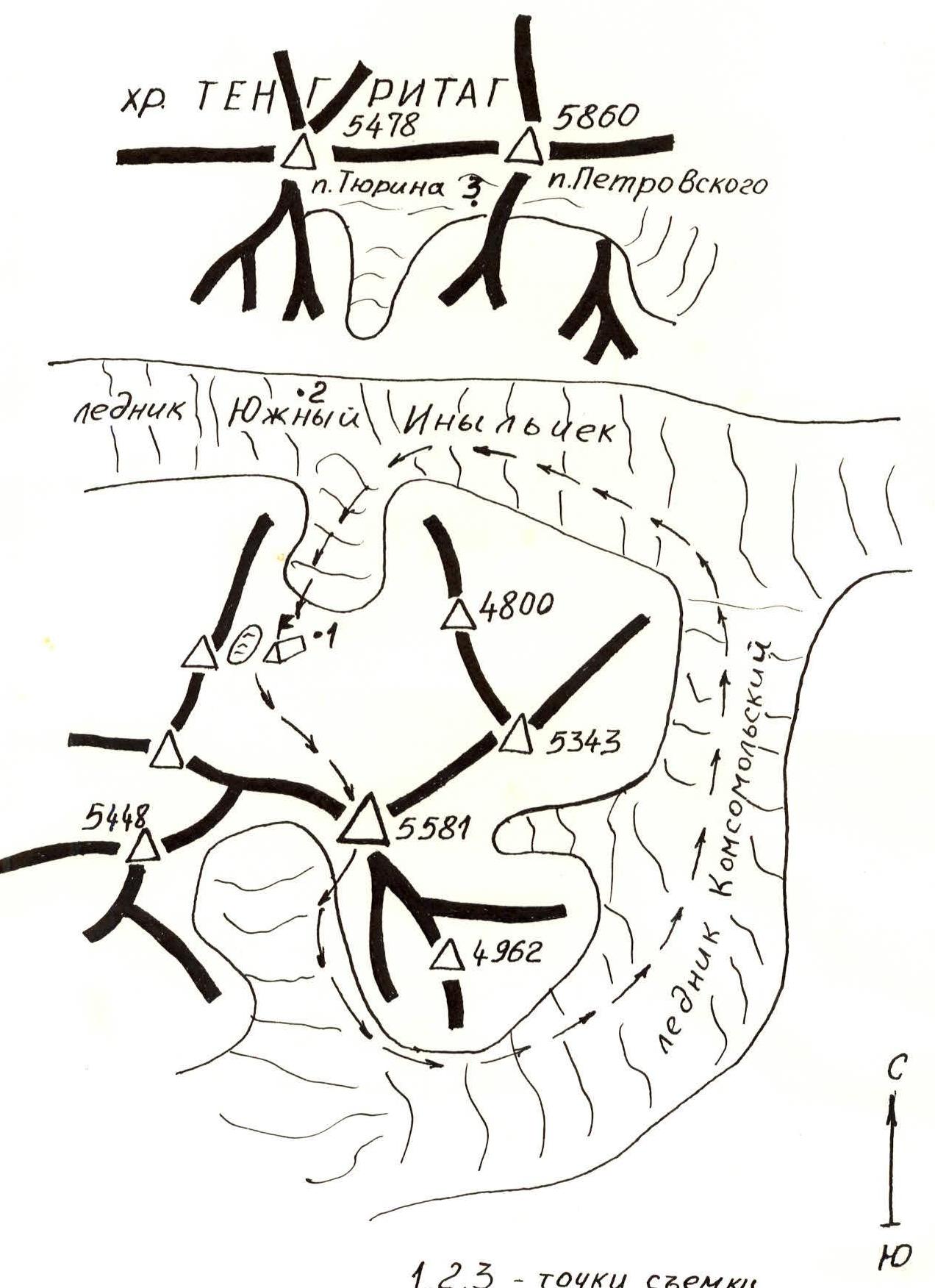
Map-scheme of the area M 1:100 000
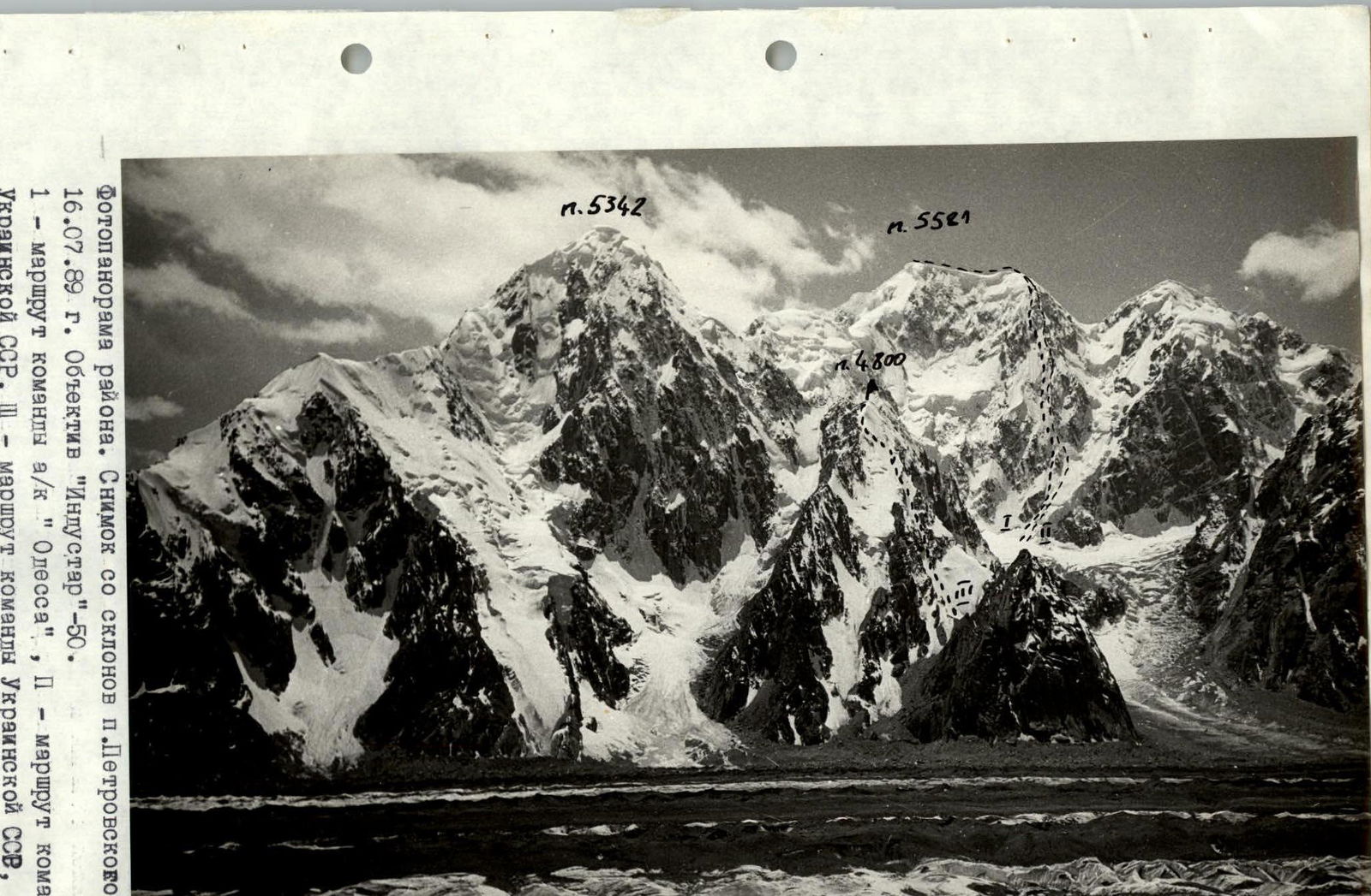
Photopanorama of the area. Photo from the slopes of p. Petrovskogo. August 16, 1989. Lens "Industar"-60.
I — route of the team from ak "Odessa", II — route of the team from Ukrainian SSR, III — route of the team from Ukrainian SSR (first ascent, training).
Brief Overview of the Ascent Area
The ascent area is located between the South Inylchek, Komosomolsky, and Shakalskogo glaciers. Previously, no ascents were made in this area. The area is characterized by:
- extensive glaciation
- lack of easy access routes, ascents, and descents from peaks
- unstable weather
- abundance of precipitation
- increased avalanche danger
- diversity of ice and snow structures
- snow-covered rocks
- presence of steep ice walls
The path to the ascent area begins from the Inylchek settlement. From there:
- by vehicle to the Maydadyr border post (base of MAC "Tian Shan");
- then by helicopter to the base camp location, on the left (orographically) lateral moraine of the South Inylchek glacier below p. 5581 (p. Dobrovol'skogo) near the lake.
From the base camp on the lateral moraine, it's a one-hour walk to the glacier along the right (in the direction of travel) part of the glacier towards the icefall. From the start of the icefall:
- up and to the right along a scree-filled couloir — one hour to a steep snow ridge;
- then left, traversing along rock shelves to the overnight location on a plateau below the peak (4000 m).
This is a convenient location for the assault camp. The approach to it is the only possible and safe route.
Tactical Actions of the Team
The team followed the route in full accordance with the tactical plan and time schedule. Weather conditions during the ascent allowed the team to follow the main variant, i.e., with two overnight stays on the wall. Bivouacs were located in tactically planned areas.
Almost the entire route was climbed by teams autonomously. Only on sections where rockfall or icefall was possible were ropes set up (R3–R4, R9–R10, R14–R15). On sections R2–R3, R3–R4, R4–R5, the first climber used two "Ice-Fifi" hooks.
The first climber generally ascended with one "impact" tool and one "Ice-Fifi" hook attached to their belt.
The first team climbed on a single UIAA-certified rope. Subsequent teams climbed on double Soviet-made 10mm ropes, using pitons left by the first team. Equipment was passed between stations.
No issues arose during the ascent, and the team had sufficient technical means to tackle any terrain.
To maintain a high pace, leading climbers in teams typically changed every 2 hours. Having individual rations also contributed to maintaining the pace.
The team brought ice screws with varying thread pitches. In the lower part of the route, two-start screws with a wide pitch were used, while in the upper part, screws with a fine thread pitch were used. Using screws with a fine thread pitch prevented "lens" formation in frozen ice.
Anchor points (stations) were organized using three interconnected pitons, whenever possible, away from potential icefall.
During sections R2–R3, R3–R4, R4–R5, the first climber was belayed particularly carefully. Drifting snow and falling ice fragments hindered voice communication. These obstacles were constant, and movement did not stop.
Throughout the route, the team maintained visual and voice contact with the team from ak "Odessa". Radio communication with the base camp was also maintained.
As the team reached the summit, a part of the rescue team ascended to the upper reaches of the Komosomolsky glacier to assist with the descent. Ice screws with a "spinning" feature were used during the descent.
According to the tactical plan, the team descended via the southern slopes of p. 5581 and returned to the base camp on the same day.
| Rock Pitons | Chocks | Ice Pitons | UIAA Symbol Diagram | Cat. of Diff. | Length (m) | Steepness (deg.) | Remarks |
|---|---|---|---|---|---|---|---|
| - | - | - | 4 | 100 | 40 | R0, 4000 m, July 18, 1989, 2:00 | |
| - | - | 30 |   | 4 | 100 | 45 | R1 |
| - | - | 50 |  | 4 | 200 | 60 | R2 |
| 14 climbing hours, July 18, 1989, 16:00 | |||||||
| 3 | - | 50 |  | 6 | 240 | 80 | R3 |
| - | - | 25 |  | 6 | 100 | 75 | R4 |
| 3 | - | 15 |  | 6 | 60 | 75 | R5 |
| 12 | 4 | - |  | 5 | 100 | 70 | R6 |
| - | - | - |  | 5 | 240 | 70 | R7, 4700 m |
| 14 climbing hours, July 18, 1989, 16:00 | |||||||
| - | - | 15 |  | 5 | 140 | 65 | R8 |
| 3 | 2 | 10 | 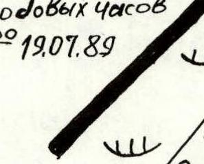 | 5 | 80 | 70 | R9 |
| 5 | 4 | - |  | 6 | 40 | 75 | R10 |
| 10 | - | - | 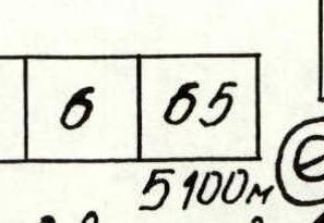 | 6 | 40 | 70 | R11, 5100 m |
| - | - | 15 |  | 5 | 100 | 55 | R12 |
| - | - | 10 |  | 4 | 40 | 60 | R13 |
| 9 climbing hours, July 19, 1989, 18:20 | |||||||
| 0 | - | 5 |  | 6 | 60 | 80 | R14 |
| - | - | 5 |  | 4 | 60 | 60 | R15 |
| - | - | 5 | 4 | 200 | 60 | R16 | |
| - | - | - | 2 | 300 | 20 | R17 | |
| - | - | - | 5581 m | - | - | - | R18 (summit) |
| 9 climbing hours, July 20, 1989, 19:00 | |||||||
| Total: | 40 | 10 | 275 | 32 climbing hours |
Route Description by Sections
Approach to the wall from the assault camp on the plateau (4000 m) in teams (crevasses) — one hour.
R0–R1. Snow slope 30°. Snow is dense, belay via ice axe.
R1–R2. Crossing the bergschrund, 1.5 m wall. Then a steep firn slope. Second bergschrund, 2.5 m wall. Steepness increases. Teams move autonomously with piton belays.
R2–R3. Ice walls. The first climber uses "Ice-Fifi".
R3–R4. On the upper part of section R3–R4 (40 m), ropes were used.
R4–R5. During the day, drifting snow is continuous, and ice fragments fall. Noise from the drifting snow hinders communication between climbers. Ice falls in small pieces, but it's necessary to watch out to avoid getting hit in the face.
R5–R6. Ice wall with rock outcrops. Rock pitons and chocks are used. Climbing is challenging.
R6–R7. Movement along a buttress. Rocks are monolithic, cracks are filled with ice and snow. Arrival at the bivouac site. Necessary to smooth out the snow drift and carve out a spot for the tent. Semi-reclined overnight stay. Belay organization via rock pitons.
R7–R8. Left of the buttress, traversing along ice walls.
R8–R9. Initially, "layered ice". Then a slight flattening. Dense snow lies here, but it's not yet firn. Challenging to organize a belay. Need to dig pits up to 0.8 m for ice screws. The first climber uses firn pitons.
R9–R10. Steep ice couloir with overhanging walls.
R10–R11. Embedded stones in the ice. Roped belay. Intermediate station under a corniche. During snowfall, snow flows down the couloir in streams, making movement difficult. The couloir then leads to a buttress. Under the wall, there's a snow drift. Snow inside is porous and crusted. Can dig a cave for a sitting overnight stay. The entrance is easily closed with a sleeping mat.
R11–R12. Directly above the cave, a rock wall. Cracks are filled with ice and snow. Roped belay.
R12–R13. Steep snow-ice slope. Ice crumbles; attention to belay is crucial!
R13–R14. Attention to belay is crucial!
R14–R15. Ice chimney. Rock outcrops. Belay — rock and ice pitons. Exit to the left buttress. Ropes.
R15–R16. Steep snow ascent. Snow is waist-deep, sometimes deeper. Need to dig pits and reach the ice.
R16–R17. Upon reaching the dome — ice with gaps.
R17–R18. Along the dome, avoiding cornices on the right part, exit to the summit. Simultaneous movement in teams.
Technical photograph of the route, July 15, 1989, 10:00, distance 5 km from a helicopter. Lens "Industar"-50.


