
Report
On the first ascent to Dinosaur Peak via the NW wall, 6Az category of difficulty, by the team from Krasnoyarsk Krai (REDFOXTEAM) from October 11 to 15, 2020.
I. Climbing Report
| 1. General Information | ||
|---|---|---|
| 1.1 | Full name, sports rank of the leader | Zhigalov Alexander Vladimirovich — Master of Sports |
| 1.2 | Full name, sports rank of the participants | Ivanov Timofey Pavlovich — Candidate for Master of Sports |
| 1.3 | Full name of the coach | Zakharov Nikolai Nikolaevich, Balezin Valery Viktorovich, Zhigalov Alexander Vladimirovich |
| 1.4 | Organization | Krasnoyarsk Krai Alpine Federation |
| 2. Characteristics of the Climbing Object | ||
| 2.1 | Region | Sayan Mountains |
| 2.2 | Valley | Western Sayan, Ergaki Ridge |
| 2.3 | Section number according to the 2013 Classification Table | 6.2 |
| 2.4 | Name and height of the peak | Dinosaur Peak — 2221 m |
| 2.5 | Geographical coordinates of the peak | |
| 3. Characteristics of the Route | ||
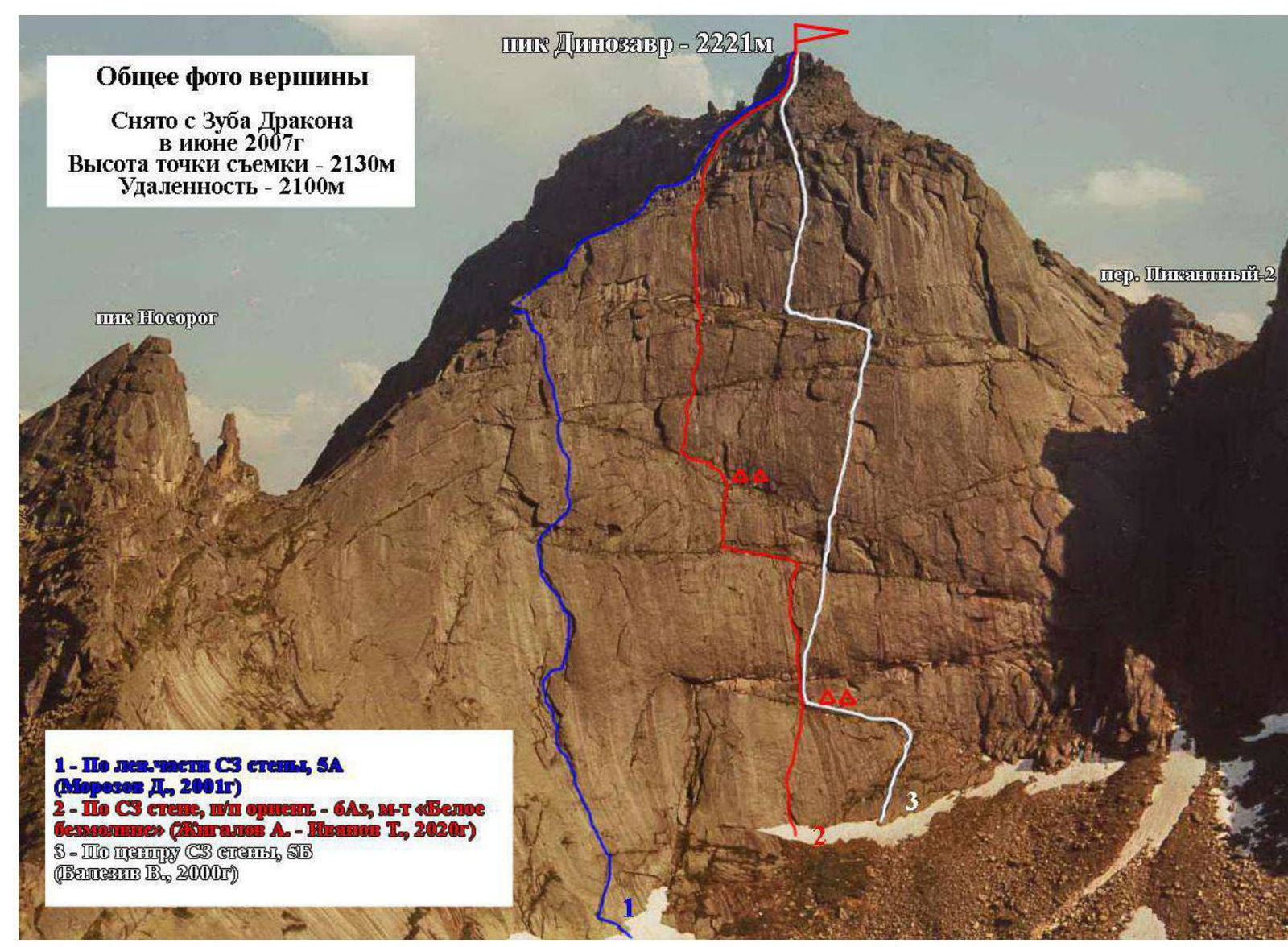
| 3.1 | Name of the route | Via the NW wall "White Silence" |
| 3.2 | Proposed category of difficulty | 6Az |
| 3.3 | Degree of route development | First ascent |
| 3.4 | Nature of the route terrain | Combined |
| 3.5 | Elevation gain of the route | 450 m |
| 3.6 | Route length | 800 m |
| 3.7 | Technical elements of the route (total length of sections of various difficulty categories with indication of the terrain type (ice-snow, rock)) | Category I difficulty. Ice/rock/combination — none. Category II difficulty. Ice/rock/combination — none. Category III difficulty. Ice/rock/combination — 265 m. Category IV difficulty. Ice/rock/combination — none. Category V difficulty. Rock/combination — 15 m. Category VI difficulty. Rock — 520 m. Rock VI, A2 — 230 m. Rock VI, A3 — 290 m |
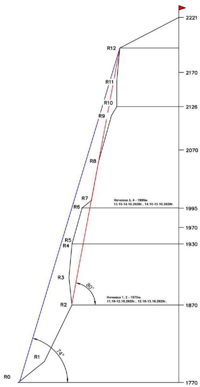
| 3.8 | Average steepness of the route, (°) | 74° |
| 3.9 | Average steepness of the main part of the route, (°) | 80° |
| 3.10 | Descent from the summit | Via Zakharov N. N.'s route, 1B category of difficulty, to Pikanthny Pass. |
| 3.11 | Additional characteristics of the route | Lack of water. Available as snow and ice on ledges |
| 4. Characteristics of the Team's Actions | ||
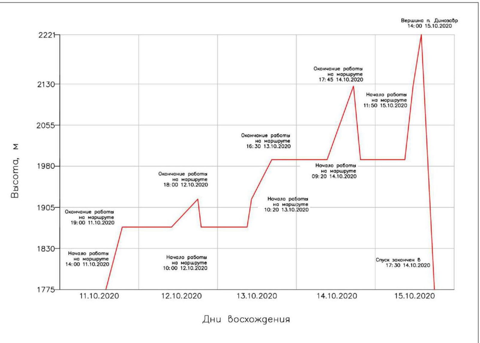
| 4.1 | Time of movement (team's working hours, indicated in hours and days) | 27 h 20 min — 5 days |
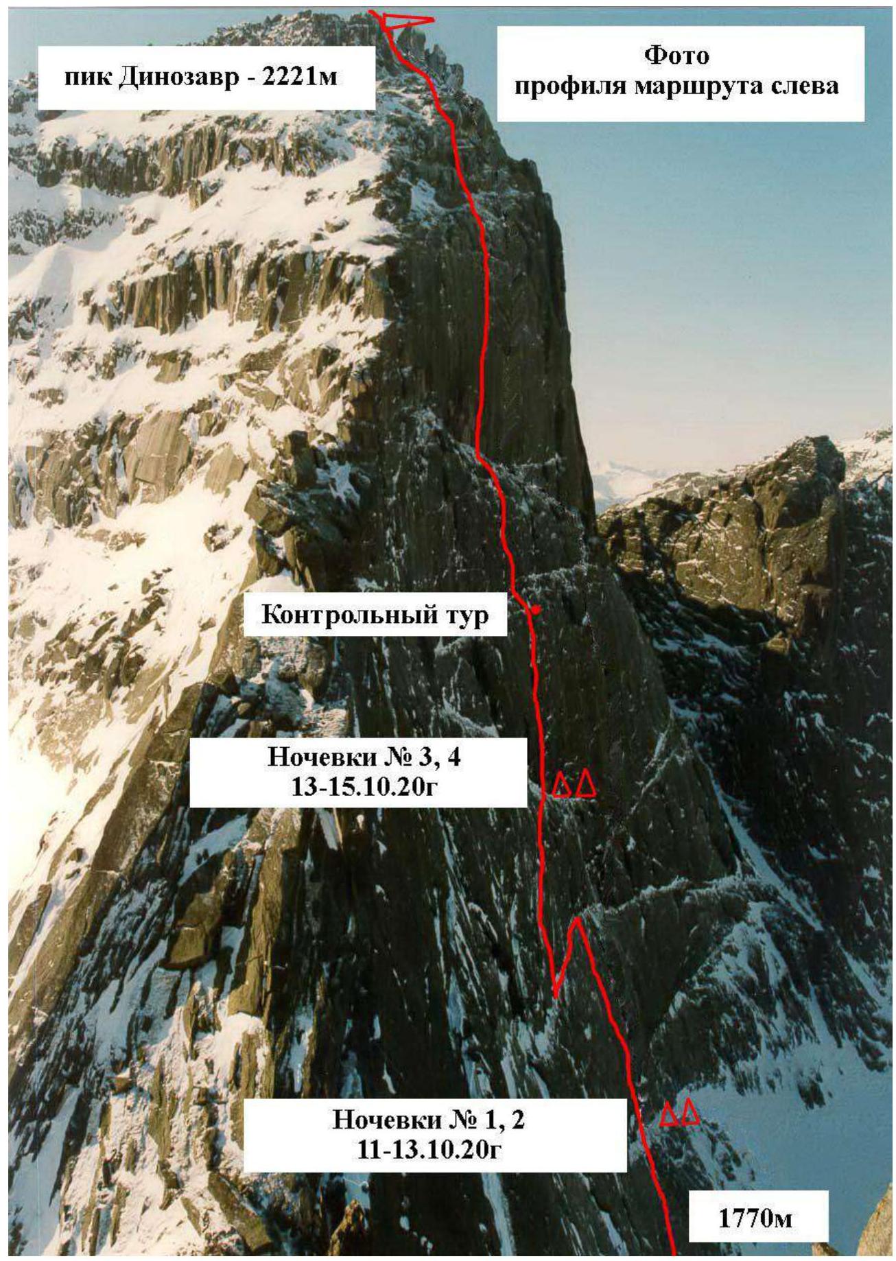
| 4.2 | Overnights | On ledges, in a tent |
| 4.3 | Time spent on route preparation | None |
| 4.4 | Departure for the route | 14:00, October 11, 2020 |
| 4.5 | Arrival at the summit | 14:00, October 15, 2020 |
| 4.6 | Return to base camp | 17:30, October 15, 2020 |
| 5. Characteristics of Weather Conditions | ||
| 5.1 | Temperature, °C | –2, –8 |
| 5.2 | Wind speed, m/s | 10–15 |
| 5.3 | Precipitation | Snow |
| 5.4 | Visibility, m | Limited |
| 6. Person Responsible for the Report | ||
| 6.1 | Full name, e-mail | Zhigalov Alexander Vladimirovich, 0jog@bk.ru Ivanov Timofey Pavlovich, timofey_ivp@mail.ru |
II. Climbing Description
1. Characteristics of the Climbing Object
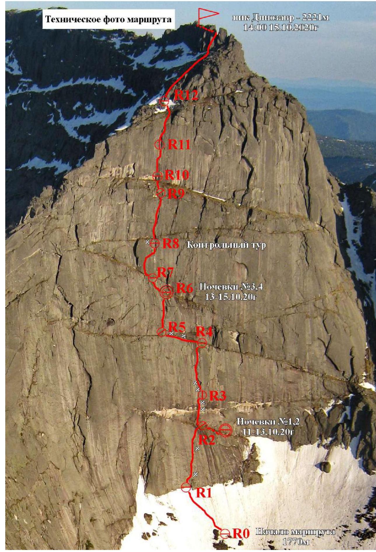
 1.2. Photo of the route profile
1.3. Drawn profile of the route
Profile of the route up the NW wall to Dinosaur Peak (2221 m)
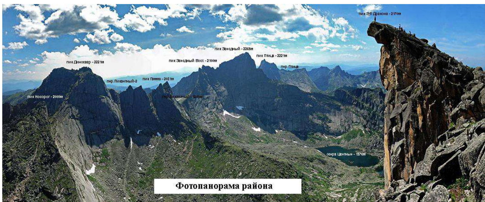
1.4. Photopanorama of the area indicating the names of peaks, their heights, and passes
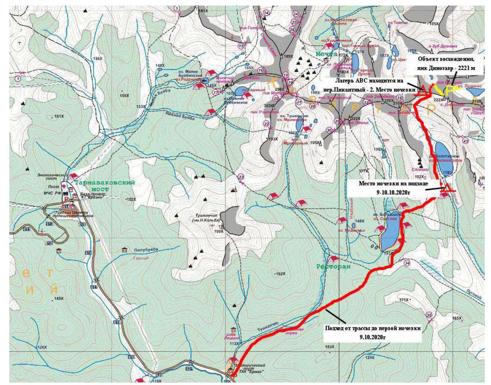
1.5. Map of the area at a scale of no more than 1:80000, schematic map of the climbing object.
2. Characteristics of the Route
2.1. Technical photograph of the route
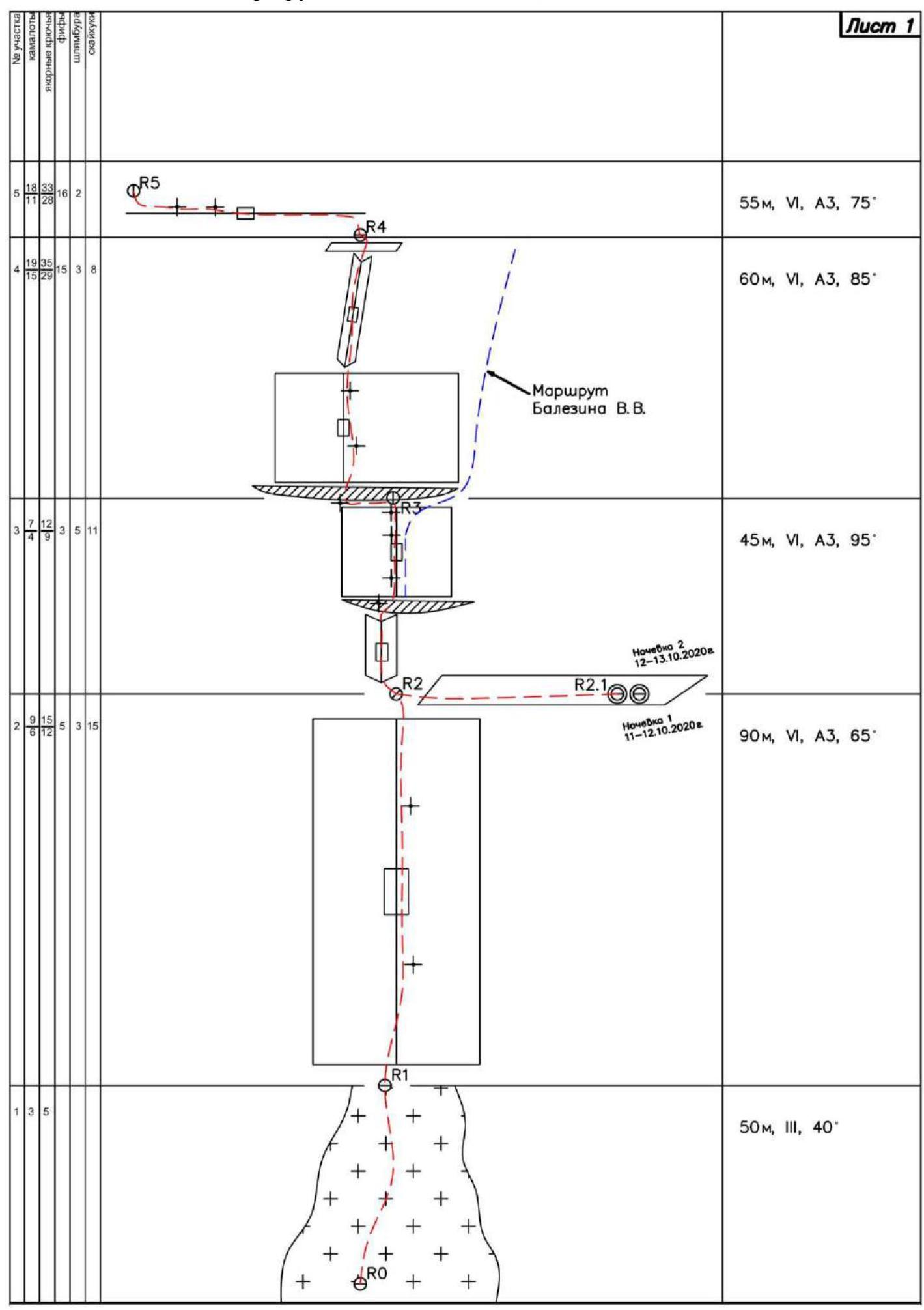
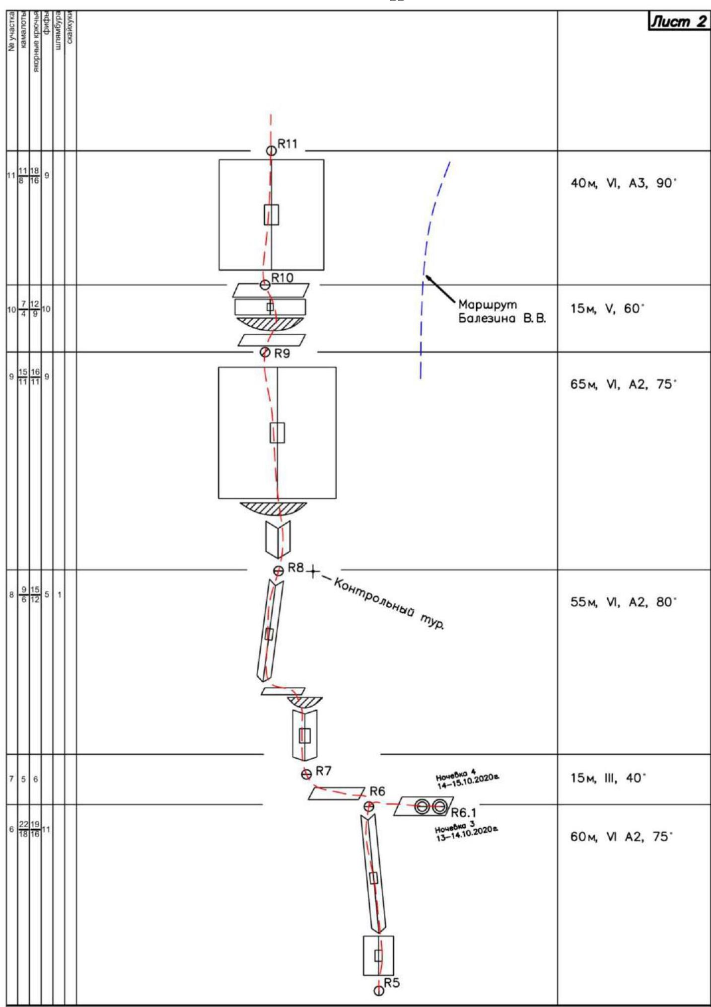
2.3. Diagram of the route in UIAA symbols, drawn to a scale of 1:2000
 |
|---|
| 12 |
3. Characteristics of the Team's Actions
3.1 Brief description of the route passage.
| Section | Description | Photo Number |
|---|---|---|
| R0–R1 | Section traversed by free climbing, on mirrors covered with snow. | |
| R1–R2 | Long monolithic wall with an angle of 60–70°, traversed using skyhooks. 2 bolts placed on the section. Occasional blind cracks where anchor hooks can be hammered in with the tip, insurance dubious. 50 m to the right of station R2 is a small 1.5 m wide ledge. Overnight stay 1, 2. | Photo 1 – Photo 2 |
| R2–R3 | At the start of the section, an inner corner traversed on anchors, cracks filled with ice. Inner corner transitions into a small ledge with a bolt. Further up a vertical wall on skyhooks and bolts to the next ledge. 4 bolts placed on the section. Key section of the route. | Photo 3 — Photo 4 |
| R3–R4 | To the left from the station under the ledge and up parallel to the ice rivulet 15 m on a vertical monolithic wall on skyhooks to ice-filled cracks. Further up a series of cracks and an overhanging inner corner to a flattening groove. Along the groove-corner, exit to station R4. An ice rivulet runs along the inner corner, freezing thickly. Relief hard to reach. Insurance on anchor hooks and bolts. местами крючья забиты в ледовые нашлёпки и кочки с землёй. Key section of the route. | Photo 5 |
| R4–R5 | Large traverse left on bare slabs, angle 75°, section length about 55 m. Insurance unreliable, mainly on frozen grass. Sometimes on cracks in layered rock and ice-filled crevices. 2 bolts placed on the section. AITC carried out using rock friend on iced-up cascades. Difficulty for both first and second participants. In summer, this section will be extremely challenging. | Photo 6 |
| R5–R6 | Wall turning into an inner corner, traversed on anchors, friends, and camalots. Cracks | |
| filled with ice and overgrown with grass. Station R6 on a ledge, 5 m to the right is a convenient ledge for a tent. Overnight stay 3, 4. | Photo 7 | |
| R6–R7 | Small traverse left on inclined slabs about 15 m. To the base of an overhanging inner corner. | Photo 8 |
| R7–R8 | Up a series of inner corners left. Section traversed mainly on camalots, sometimes overhanging. In the upper part, it smoothly turns right. On station R8, a bolt with a capsule containing a note — control tour. | Photo 9 |
| R8–R9 | Further along an inner corner right under a ledge. Through the ledge — exit to a wall with crevices. Up a series of crevices to a small chimney. The chimney is cut by crevices and cracks, a station can be made in different places. At the exit, the wall flattens, a convenient ledge — station R9. | Photo 10 |
| R9–R10 | Section passes under a ledge on inclined slabs. Transition through the ledge on the right and exit to a small ledge. Closer to the wall, the ledge becomes wider and more convenient. Possible to set up a tent on R10. | |
| R10–R11 | One of the key sections of the route. Monolithic overhanging wall with a single thin crack. Traversed on friend tips and anchors. Further, the crack turns into a crevice, angle about 80°. Crevice walls filled with ice. Necessary to chip away ice, clean to set up protection points. Crevice turns into a chimney. Station inside the chimney — R11. | Photo 11 |
| R11–R12 | Further through the chimney and a series of walls with crevices. AITC on small camalots and anchors with bend. Exit to a large ledge before the ridge. Convenient station. | Photo 12 |
| R12–R13 | Along the ridge about 200 m to the summit. In the upper part — through a chimney and an inner corner before the summit. | Photo 13 |
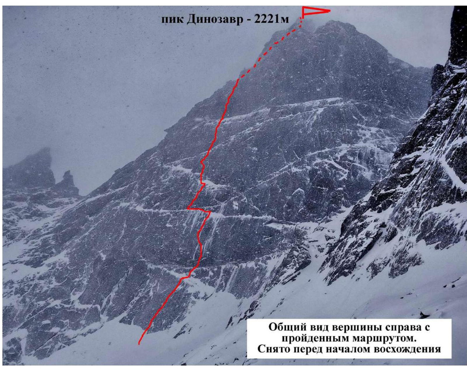
General view of the summit to the right with the traversed route. Taken before the ascent.
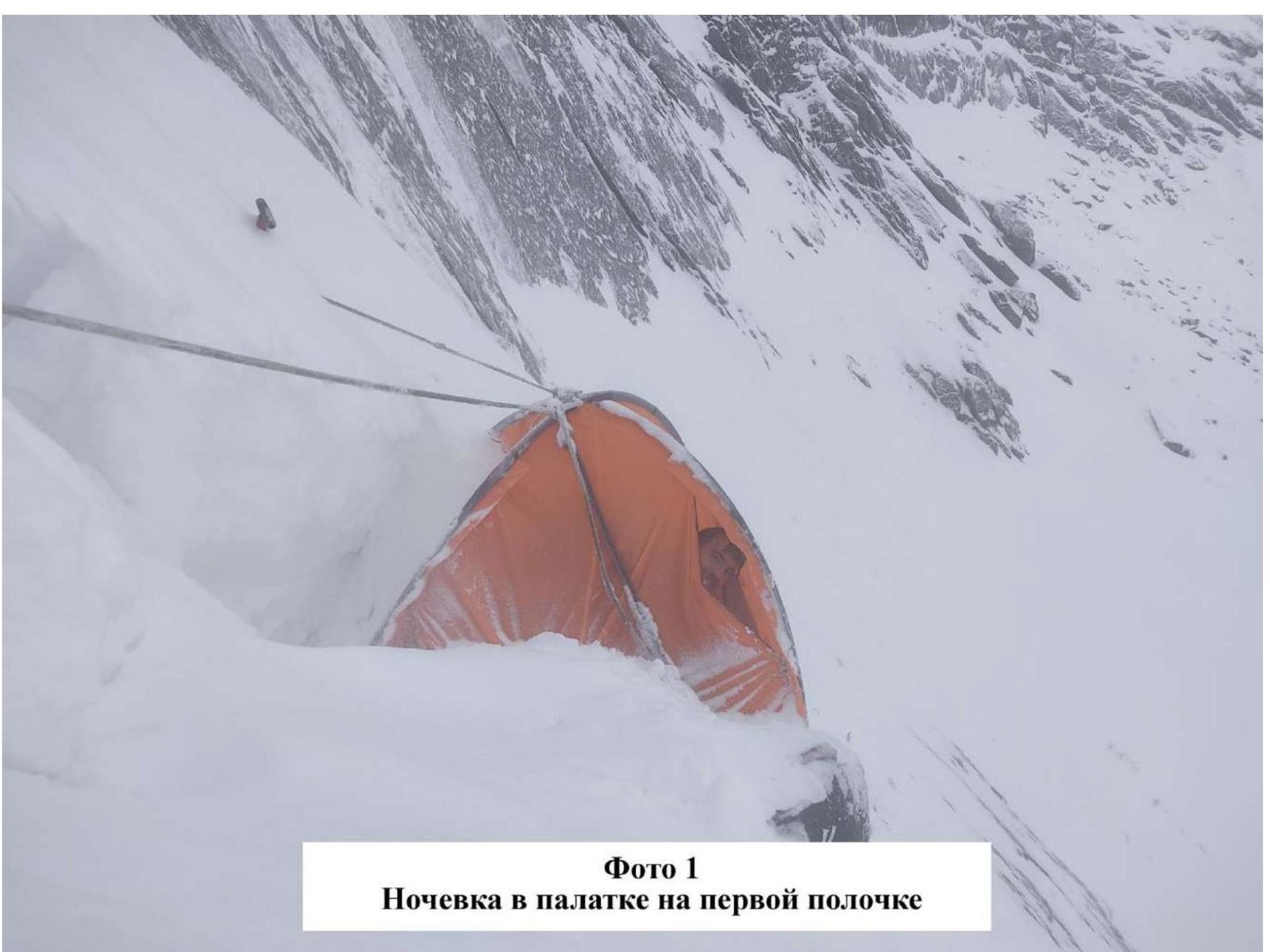
Photo 1. Overnight stay in a tent on the first ledge
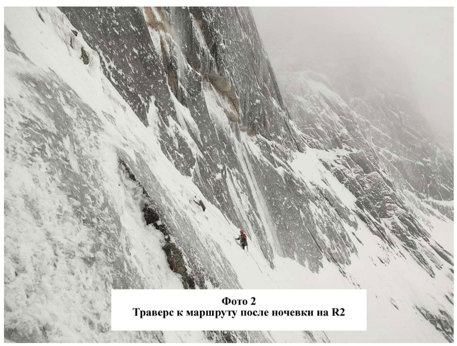
Photo 2. Traverse to the route after overnight stay on R2
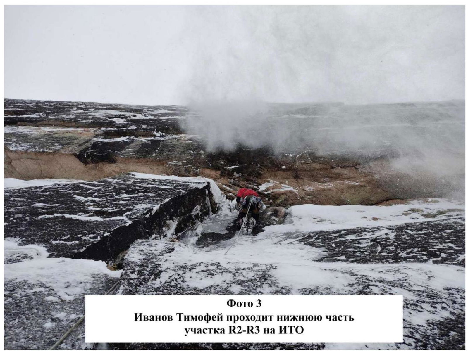
Photo 3. Ivanov Timofey traverses the lower part of section R2–R3 on AITC
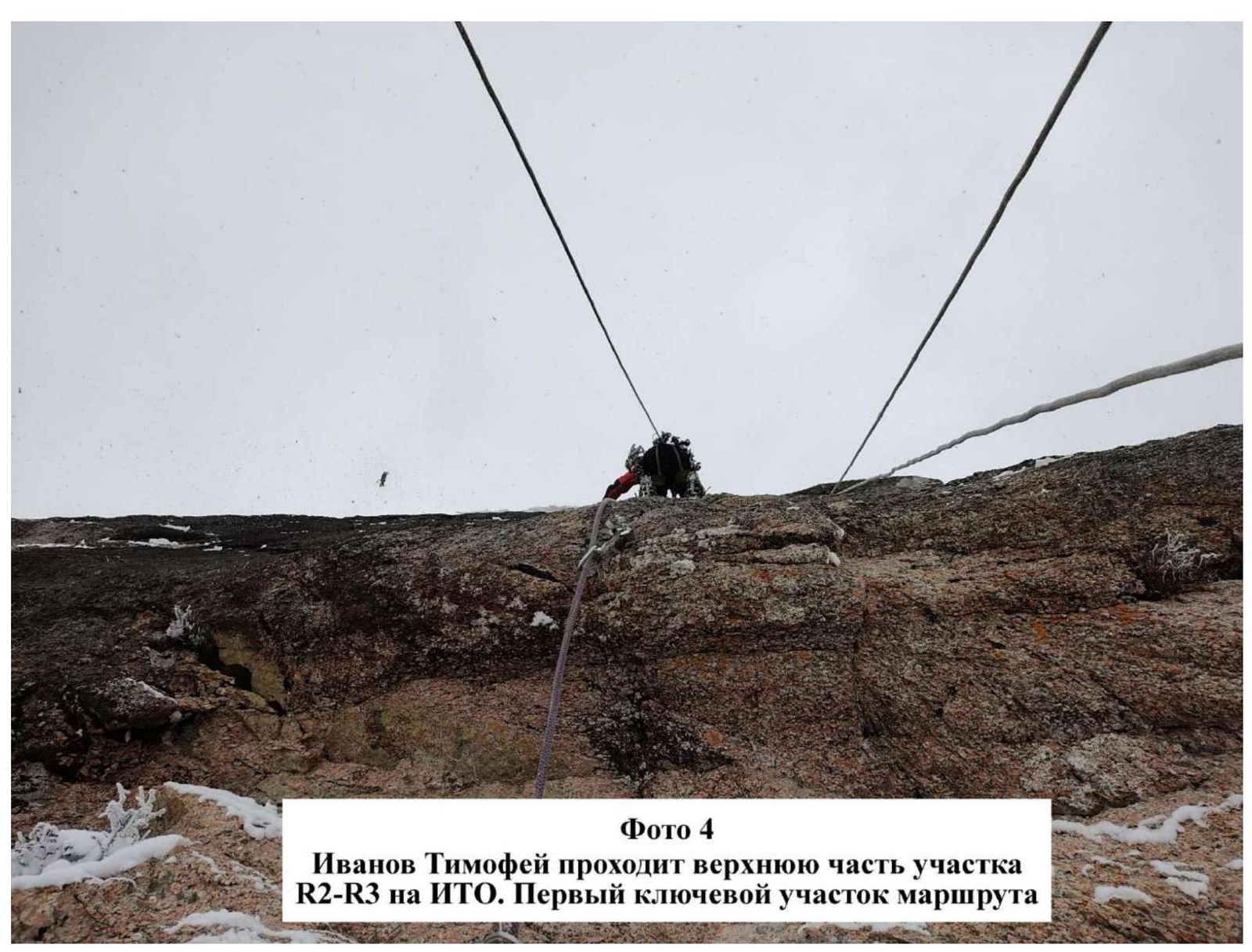
Photo 4. Ivanov Timofey traverses the upper part of section R2–R3 on AITC. First key section of the route.
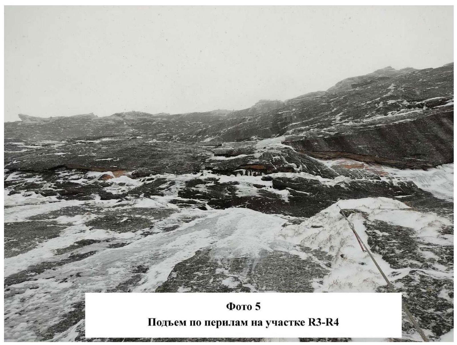
Photo 5. Ascent on section R3–R4 via ropes
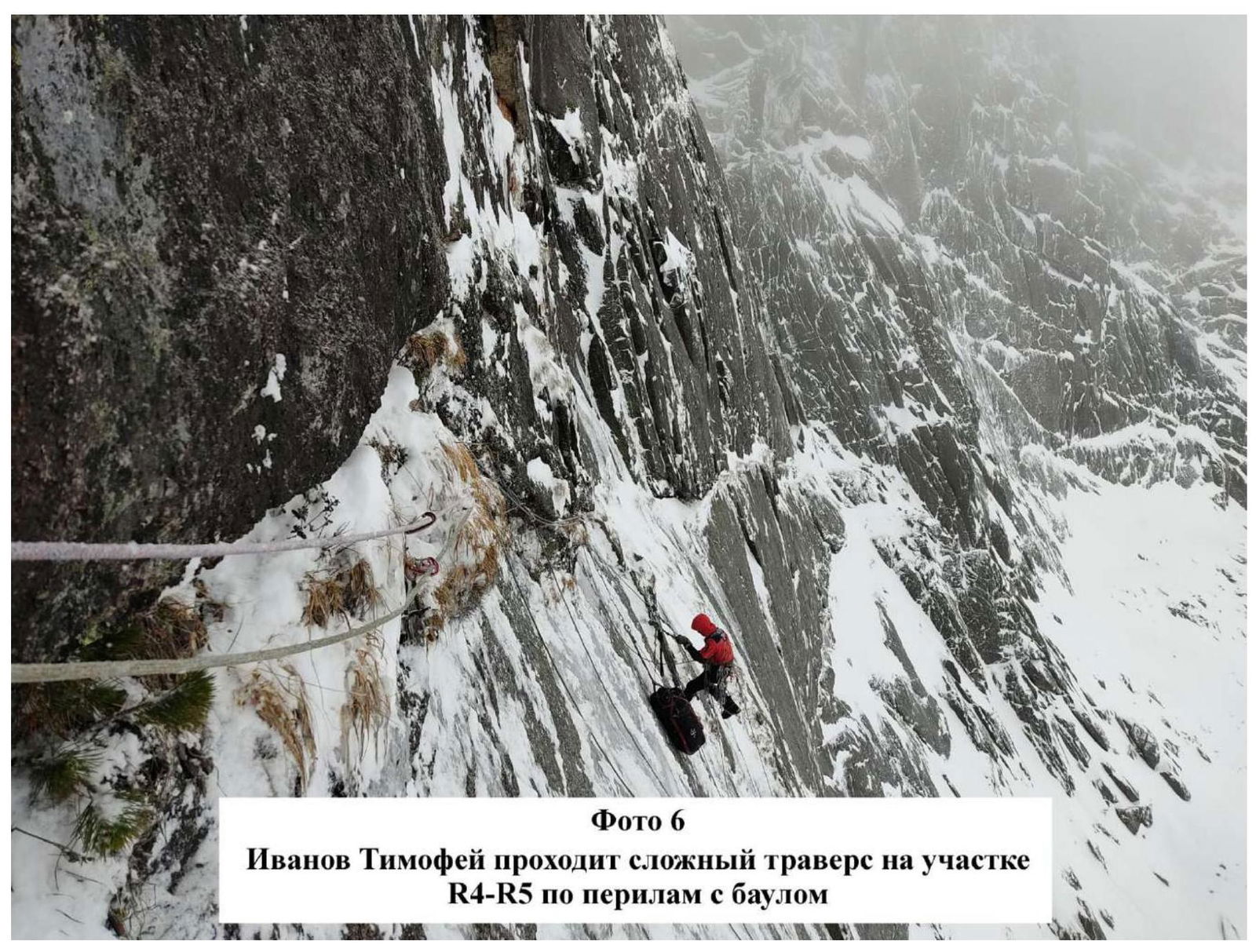
Photo 6. Ivanov Timofey traverses challenging section R4–R5 via ropes with a cow's tail.
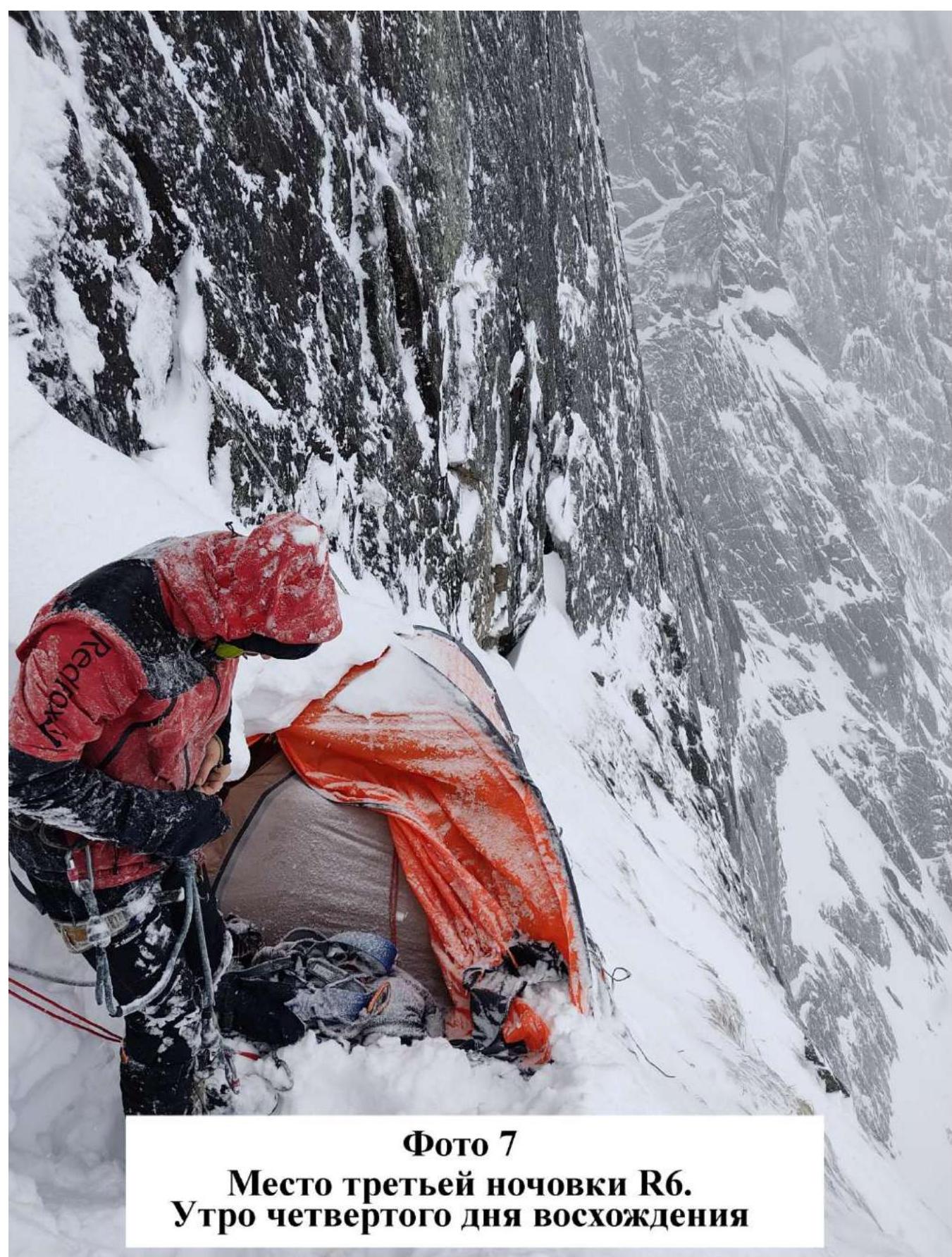
Photo 7. Site of third overnight stay R6. Morning of the fourth day of ascent.
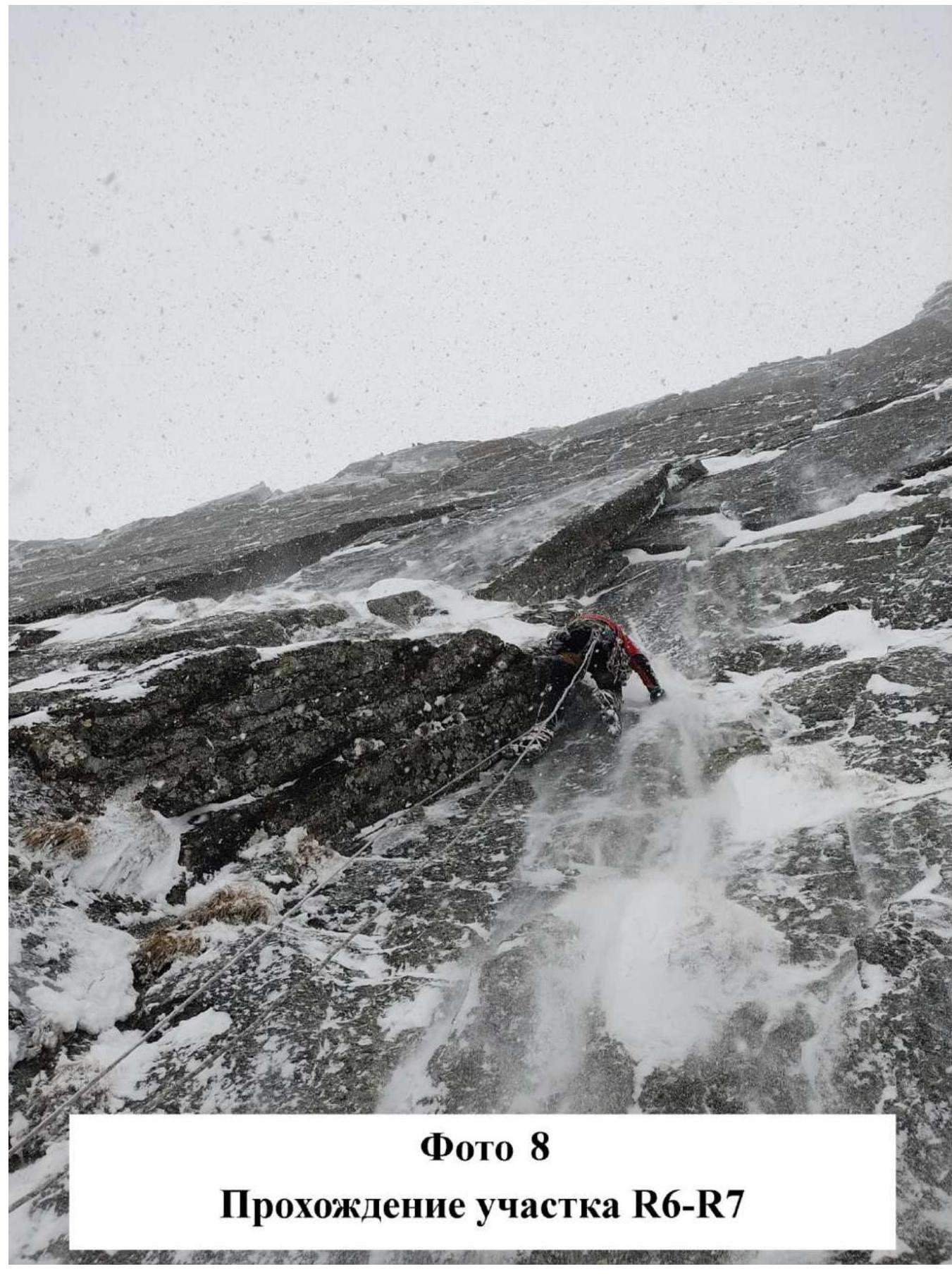
Photo 8. Passage of section R6–R7

Photo 9. Work on section R7–R8
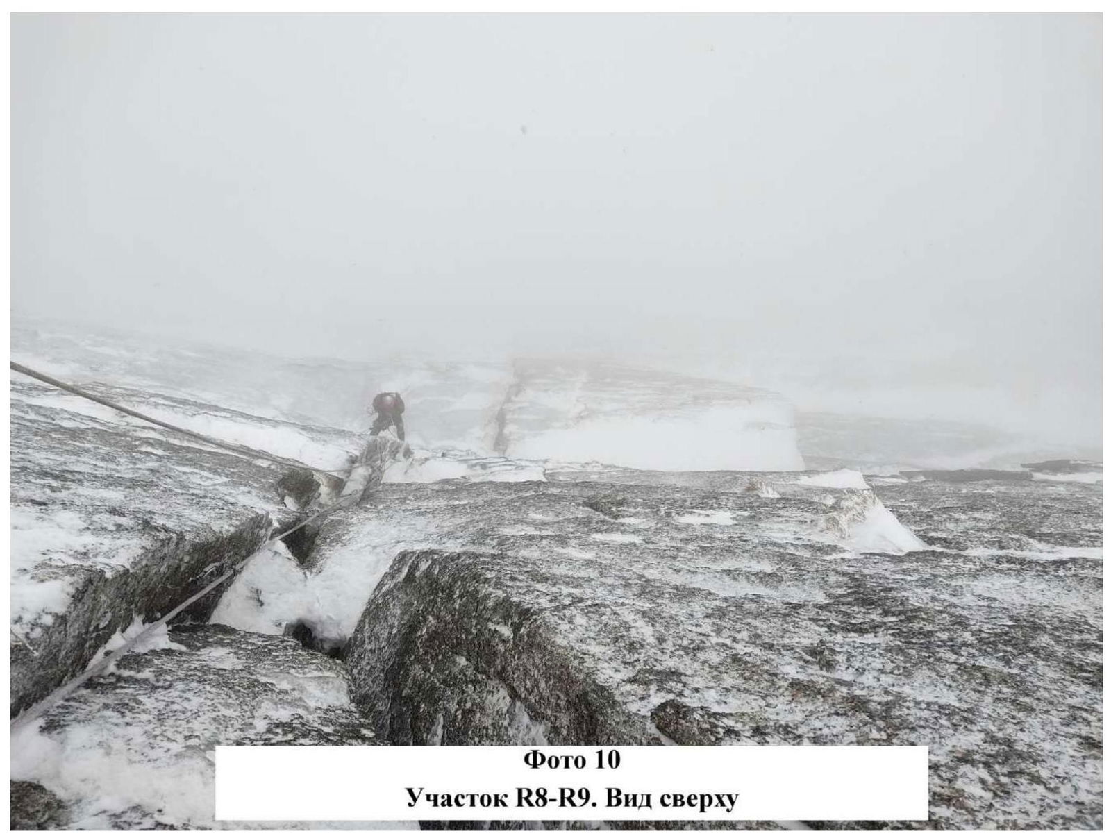

Photo 11. Zhigalov Alexander traverses section R10–R11 on AITC
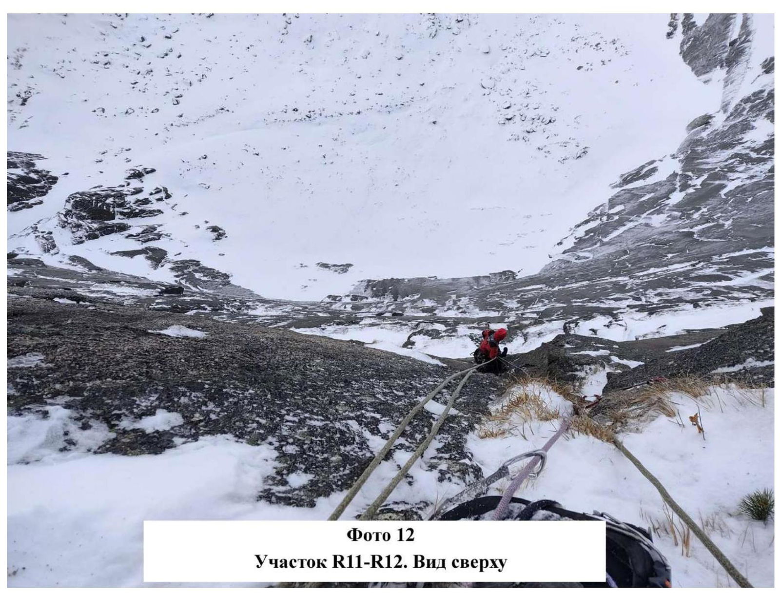
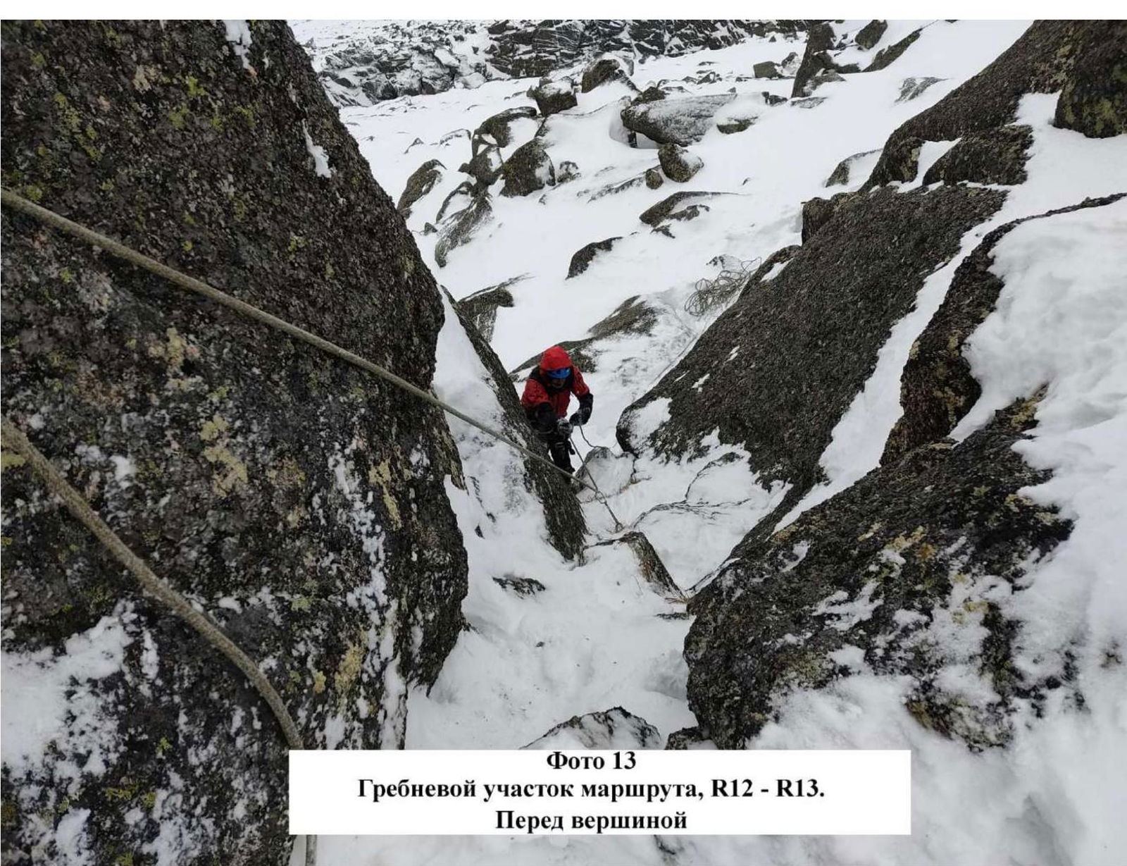
Photo 13. Ridge section of the route, R12–R13. Before the summit.
Climbing graph of the team:
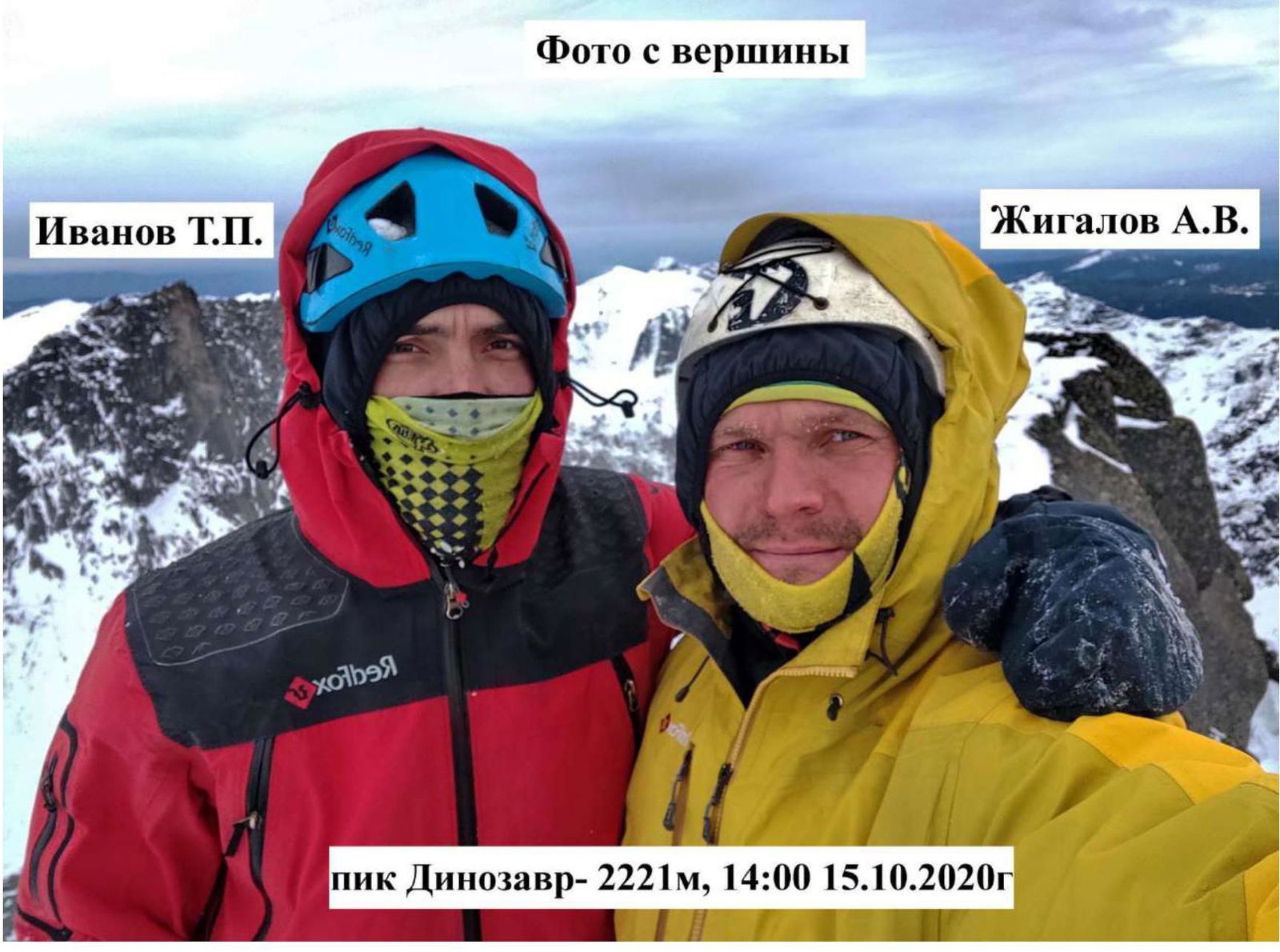
3.2. Photo of the team on the summit at the control tour.
Photo from the Summit
 3.3. In the team's opinion, the route is objectively safe due to the monolithic nature of the mountain. However, positive temperatures can cause ice rivulets to melt, which are located above section R2. Many sections have insurance on frozen grass and earth, and AITC on ice formations.
The team had mobile communication on the route via Tele2 operator.
3.3. In the team's opinion, the route is objectively safe due to the monolithic nature of the mountain. However, positive temperatures can cause ice rivulets to melt, which are located above section R2. Many sections have insurance on frozen grass and earth, and AITC on ice formations.
The team had mobile communication on the route via Tele2 operator.
There are not many places to stay overnight on the route, and they are not convenient for a tent. If there is little snow on the route, there may be no ledges at all, and instead, there will be inclined slabs under the snow.
Descent was carried out via Zakharov N. N.'s route, 1B category of difficulty. After the ascent, it is possible to descend on foot, which is a significant advantage of this climb.
The team has experience with ascents of 6A category of difficulty in this area. We believe that the route corresponds to 6Az category of difficulty. The elevation gain, length of sections with 5 and 6 category of difficulty, and angle of inclination meet the requirements of 6 category of difficulty in all parameters. The route is quite challenging, with a lot of bolt and skyhook work. Nonetheless, the route follows a logical relief from bottom to top. The winter period adds complexity to this ascent. Conditions in the off-season in this area are extremely challenging. During this time of year, temperatures fluctuate from 0 to –15 °C, and if it's warm during the day, everything is covered in ice in the evening.
To future climbers, we wish a pleasant stay on the route, to enjoy the winter Ergaki, and to be prepared for it. Good weather on the route, attentiveness, and sensitivity in actions.
4. Characteristics of Weather Conditions
The autumn period in Ergaki is very unpredictable. Previous expeditions always took place under very bad weather conditions, and this year was no exception. The weather was extremely unstable throughout the ascent. Every day:
- there was precipitation in the form of snow;
- constant wind;
- dust avalanches regularly rolled down the wall.
Daytime temperatures were: –2 °C…–8 °C. Nighttime temperatures dropped to –10 °C…–12 °C.
Comments
Sign in to leave a comment