Ascent Record
- Ascent category — rock climbing
- Region — Western Sayan, Ergaki Ridge
- Peak — Zub Drakona 2170 m via the center of the S wall of the main tower.
- Claimed — 6A first ascent
- Route characteristics: height difference — 500 m. total length — 600 m. length of 6th category sections — 220 m. 5th category sections — 150 m. average slope: entire route — 75°, main section — 90°
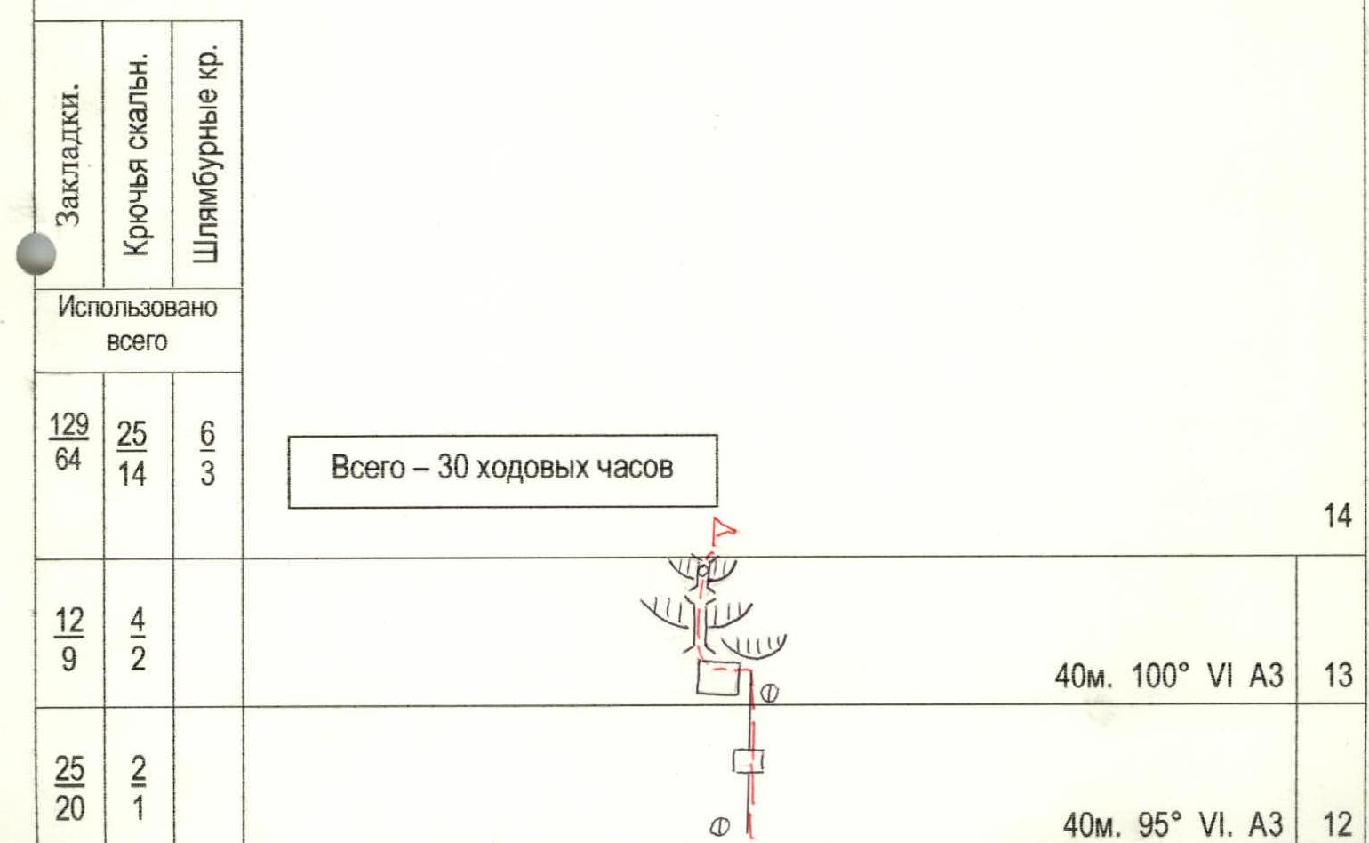
- Equipment used on the route:
| Chocks | Rock pitons | Bolt pitons |
|---|---|---|
| 129/64 | 25/14 | 6/3 |
- Climbing hours — 30. Days — 3.
- Overnights — 2
- on a grassy rock ledge in a tent, lying down.
- on a rock ledge in a tent, semi-reclining.
- Team members: Balyezin Valery Viktorovich MSMK — team leader Pushkarëv Semën MS Railko Yuriy Borisovich CMS Fyodorov Sergey Rostislavovich CMS
- Team coaches: Zakharov Nikolay Nikolayevich MSMK Balyezin Valery Viktorovich MSMK
- Departure date: to the route — June 28, 1999. to the summit — June 30, 1999. return — June 30, 1999.
- Organization: Krasnoyarsk Committee for Physical Culture and Sports
1999 year
Overview of the Region
Ergaki is a beautiful corner of Eastern Siberia, located roughly midway between the capital of Khakassia — Abakan and the capital of Tuva — Kyzyl. Ergaki is a paradise for travelers: beautiful lakes, clean rivers, rich Siberian taiga, beautiful granite peaks.
The Ergaki massif is located in the central part of the Western Sayan. The length of the massif from west to east is about 80 km, the width is about 70 km. The massif consists of a group of mountain ridges:
- Ergaki
- Metugul-Tayga
- Baldyr-Tayga
- Shepshyr-Tayga
The terrain is heavily dissected by ancient glaciers, has a dense river network, and many large beautiful lakes. This territory is characterized by an East Siberian type of climate with a long and harsh winter (prevailing air temperature in January –28–35°C). Summer in the mountains is cool (prevailing daytime temperatures in July +10–+16°C, nighttime +2–4°C). Precipitation falls on average 5–8 days a month, with frequent thunderstorms in the summer.
Almost all the peaks in the region (highest point 2281 m) have complex sheer walls with a height difference of up to 550 meters. Climbing development in the region has been carried out by Krasnoyarsk climbers since 1994. In 1995 and 1996, the Krasnoyarsk Territory Championships were held here, and in 1997 and 1998 — the Championships of Siberia and the Far East in rock climbing.
Financial difficulties forced well-known Krasnoyarsk climbers and rock climbers to look for objects for their ascents near home. Ergaki turned out to be an ideal place. A great training ground for wall climbers! Sheer monolithic rocks at minus 40 degrees Celsius proved to be a tough nut to crack even for climbers who had stormed Everest! By now, routes from 1B to 6A category have been climbed and classified.
- The first ascent route on the N wall of the Zvezdny peak (6A, combined) was climbed in February 1997 in 9 days, repeated in July 1998 in 5 days.
- The first ascent route on the W wall of the Zvezdny peak (6A, winter, summer — 5B) was climbed in winter 1998 in 5 days, repeated in summer in 2 days.
These first climbed routes have already shown the promise of the new region and brought prize places in the Russian climbing championship in the winter class. According to foreign climbers, the routes are no less complex than the famous walls in the Alps, and due to the harsh Siberian conditions, they surpass them significantly.
You can get to the Ergaki massif by bus from Krasnoyarsk via Abakan to the 221st km of the Usinskiy tract, which connects Abakan and Kyzyl. Then along the Tushkanchik river on foot for about 4 hours to the base camp.
The Ergaki massif is located in the central part of the Western Sayan (south of the Krasnoyarsk Territory). The length of the massif from west to east is about 80 km, the width is about 60 km. The Ergaki massif is heavily dissected, with many steep rock walls, deep river valleys, and lakes. The terrain is mountainous and forested with a dense river network. The relief is mid-mountain, with prevailing heights of 1300–2100 m. The highest point is 2281 m. The mountains are composed of very hard rocks, mostly syenite, with few "live" stones, and rockfalls are very rare. The routes in this region are characterized by large smooth steep slabs, steep monolithic blocks, and walls with very poor microrelief. In the lower part of the route, most of the cracks are overgrown with grass and filled with earth, which creates additional difficulties for climbing and especially for organizing protection.
The weather in the region is extremely unstable, with a lot of precipitation, and rain can fall continuously for a whole week.
In winter:
- The average thickness of the snow cover reaches 3 m, so in winter, it is only possible to move on the approaches on skis or snowshoes.
- The region is avalanche-prone!
Ergaki is characterized by an East Siberian type of climate with a long and harsh winter with frosts and snowstorms. Snow in the highlands melts only by the end of June, and falls again in September. Summer is cool, with daytime air temperatures in July +10…+15°C, nighttime around +5°C, and winter temperatures drop to –40°C. In June, there are many midges and mosquitoes.
Zvezdny peak — 2265 m. It is the most difficult and beautiful peak in the region, with sheer walls to the south, west, and north with a height difference of 300 to 600 meters.
Climbing development in the region began recently — in 1995.
In subsequent years:
- In 1996, routes of 4B, 5A, 5B categories were classified.
- In February 1997, as part of the Russian Championship in the winter class, a 6A category route was climbed on the N wall of Zvezdny peak.
- In the summer of 1997, several new routes from 3 to 5B categories were climbed.
Approach: along the Usinskiy tract (Abakan–Kyzyl) approximately to the middle of the way (to the Tormozakovskiy bridge or a bit further), not reaching Aradan. From the road, the rocky peaks can already be seen, rising steeply above the main foothills.
Note: "Ergaki" — translated from the local language means "fingers", which fairly accurately describes the nature of the local rocky peaks.
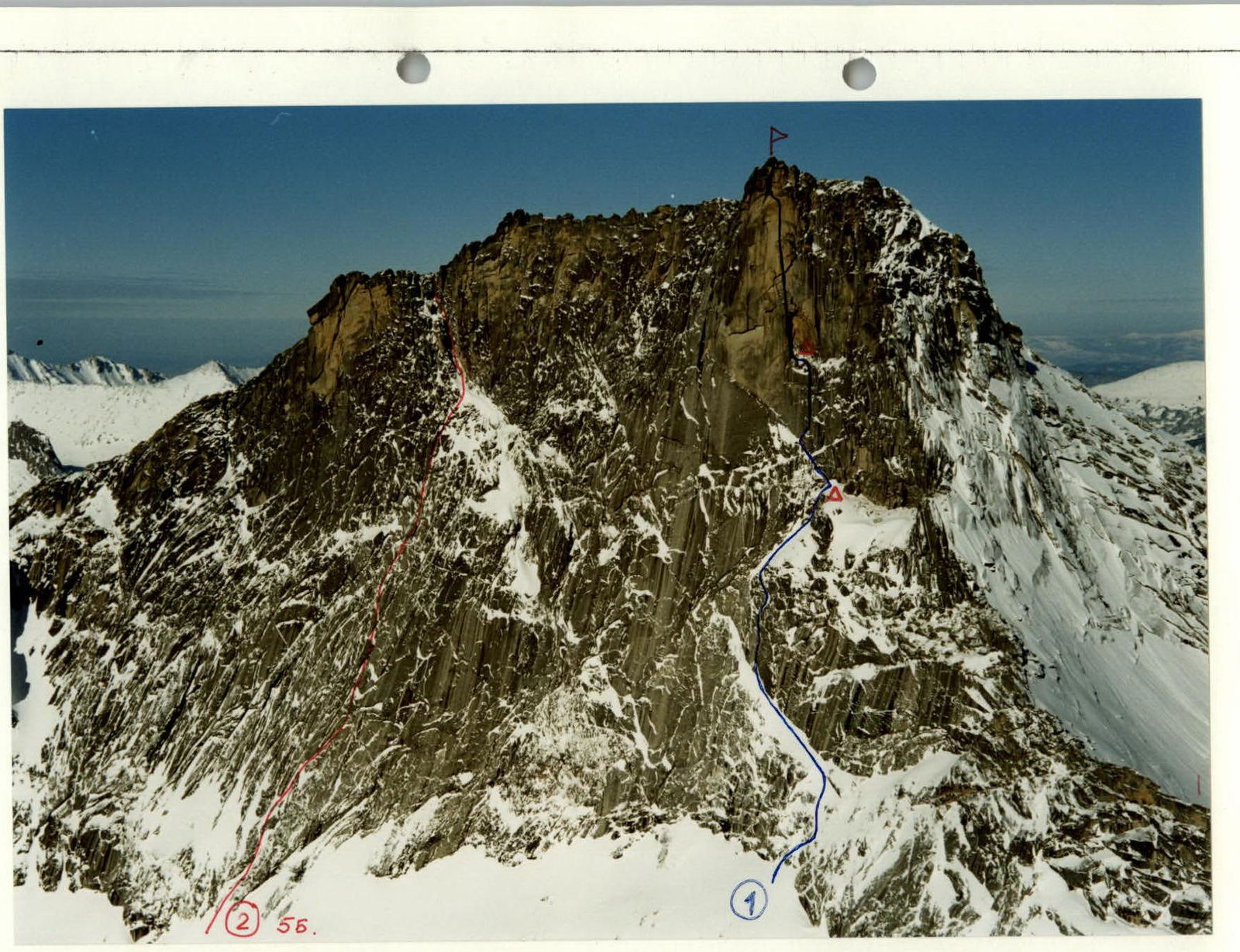
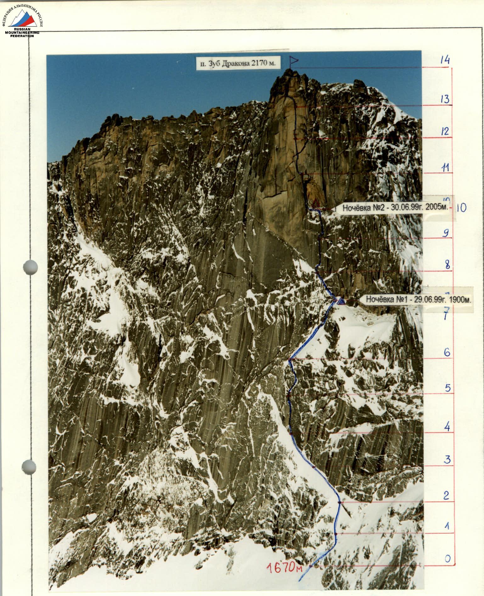
General photo of the "Zub Drakona" 2170 m peak (taken in February 1999)
- Route on the center of the S wall of the main Tower, first ascent.
- Route on the SW wall of the SW Tower 5B (1997)
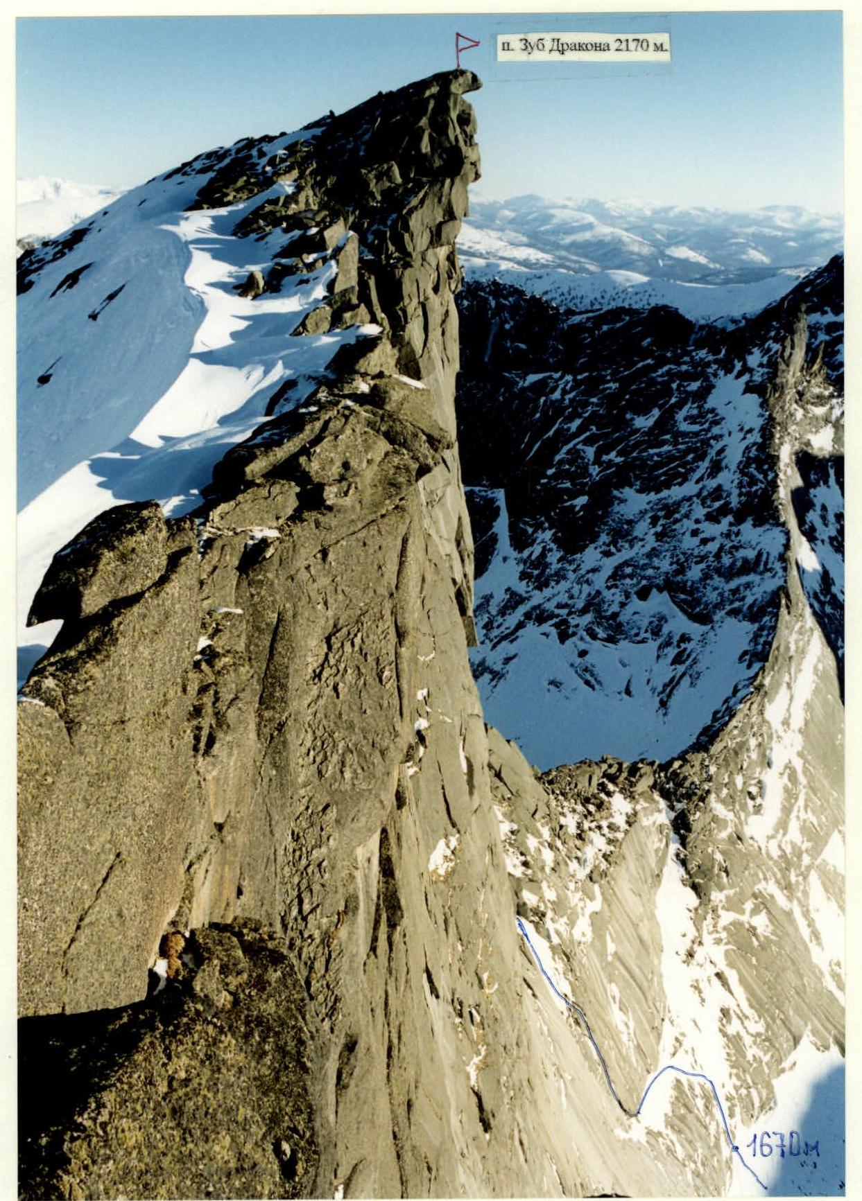
Profile of the SSW wall of the main Tower from the left (taken in February 1999 from the Central Tower). The profile of the main part of the wall is not visible, it is located a little behind the bend and passes along an even steeper S wall with an exit exactly to the summit.
Summit tower (main part of the route) Taken from overnight stop #1. One of the team members is approaching the grotto where the second overnight stop was organized. The entire route to the summit is clearly visible.
Tactical Actions
The "Zub Drakona" massif is named so due to its sharp, tooth-like summit tower with an overhanging southern wall. The relief of the wall consists mainly of large monolithic slabs and walls with very poor relief, the steepness of the wall increases from 60° at the beginning to 100° at the end. The upper part of the wall looks very problematic due to the large number of cornices and overhanging monolithic walls, so there were no attempts to climb it. After careful study of the wall, we chose a very beautiful and logical route along the center of the overhanging tower with an exit exactly to the summit. There are only two ledges on the route suitable for overnight stops (sections R7 and R10), where we planned to spend the night.
On June 28 at 9:00, the team began the ascent, with the pair Balyezin — Railko working ahead, taking turns leading. At 14:00, they reached the site of the first overnight stop, processed two ropes above the stop, the weather worsened — it started raining, and at 18:00, they stopped for the night.
On June 29 at 8:00, the pair Pushkarëv — Fyodorov started on the route. By 12:00, they reached the site of the second overnight stop and continued further processing the route, climbing two very difficult ropes, and at 21:00, they descended to the overnight stop. At night, it started raining, and they got wet.
On June 30 — fog, drizzle, strong cold wind. At 10:00, the pair Balyezin — Railko started on the route. After climbing one very difficult, overhanging rope, wet and frozen, they descended to the overnight stop at 14:00. Then the pair Pushkarëv — Fyodorov started, who, after climbing the steep (about 100°) summit tooth, reached the summit at 20:00. And half an hour later, the rest of the team members reached the summit, and an hour later, the team in full descended down to the base camp via route 2A category.
On the route, the team used the entire arsenal of modern equipment. For organizing protection, they mainly tried to use chocks, and pitons were used only when it was impossible to use chocks.
Throughout the route, "fifis" were used as points of support when climbing through thin, earth-filled cracks. The first in the rope team, as a rule, climbed on a double rope, having organized a station: one rope was fixed on it as a handrail, and on the other, they took in the second climber with top rope protection.
The main protection points (stations) were organized on at least three protection points, blocked by a local loop, with a blockage in the middle of the handrail.
There were no falls or injuries during the ascent, despite the fact that they continued to process the route during bad weather, rather than waiting it out.
Description by Sections
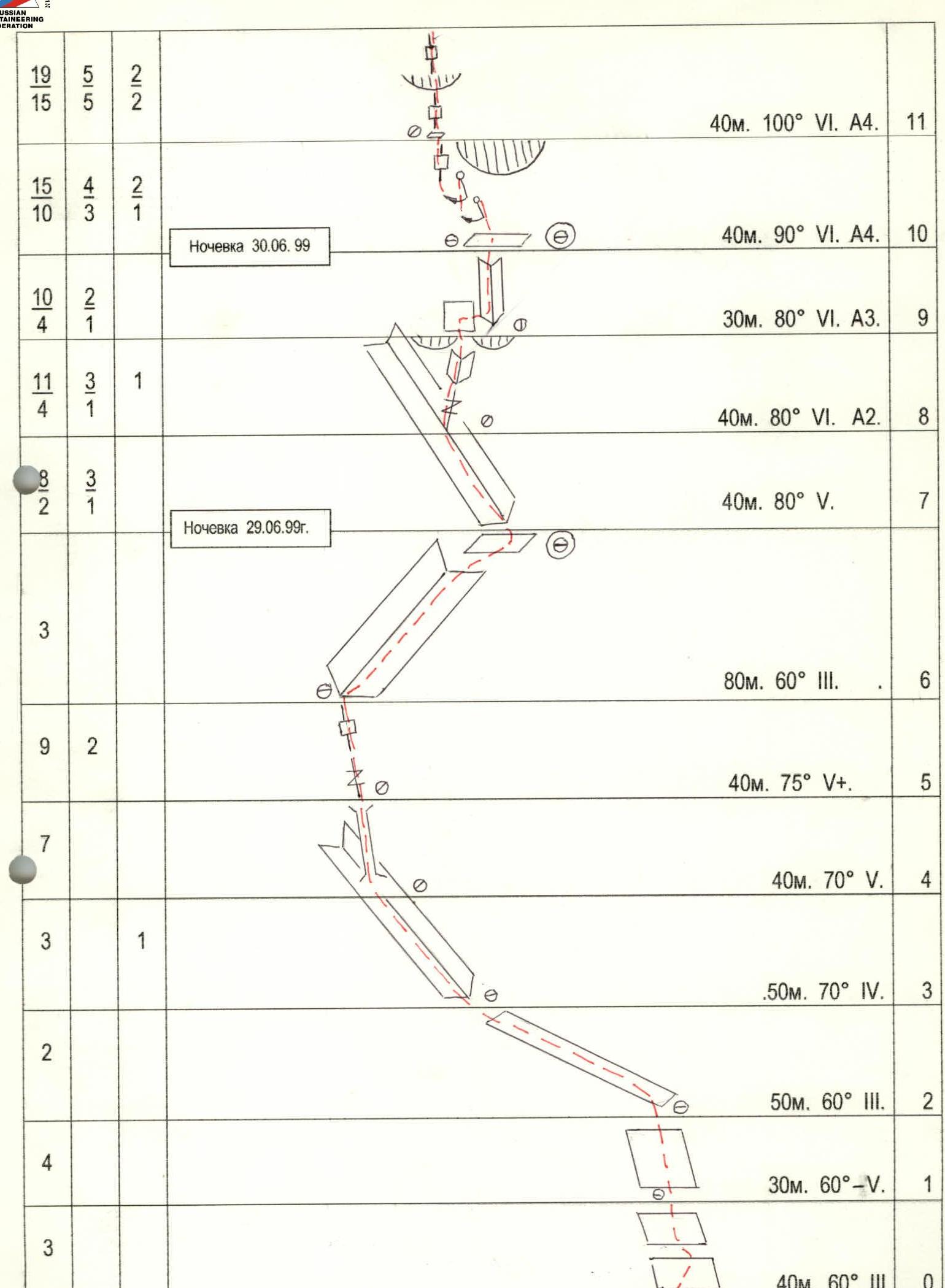
Section R0–R1. Slabs with a series of inclined ledges, heavily overgrown with grass.
Section R1–R2. Slab leading to an inclined grassy ledge.
Section R2–R3. Inclined narrow grassy ledge. Traverse left about 50 m.
Section R3–R4. Inclined left inner corner, местами сильно заросший травой.
Section R4–R5. Gradually narrowing chimney between a spall and a wall.
Section R5–R6. Steep crevice, местами с травой, ИТО.
Section R6–R7. Inclined right inner corner, heavily overgrown with grass, leading to a ledge to the first overnight stop.
Section R7–R8. Large inclined left inner corner, climbing is complex.
Section R8–R9. Exit from the corner to the right onto a spall, then a vertical complex inner corner ending in a cornice. Under the cornice, a hanging reception point on a bolt piton "petzl".
Section R9–R10. Traverse along a slab on skyhooks to the right into an inner corner, then along the corner to a ledge to the site of the second overnight stop, inside a high grotto. Climbing.
Section R10–R11. Very complex, slightly overhanging spiral left wall of the grotto, with a series of blunt vertical cracks, which are passed with the help of two pendulums to the left. Then exit to a rock finger and from it to ИТО along blunt cracks (protection on a bolt) exit to a ledge. Reception point on a "petzl" bolt.
Section R11–R12. Thin sheer six-meter crack, ИТО, leading to a ledge, then 5 meters of sheer wall on skyhooks to a thin blunt crack, along which ИТО on "fifis" exit under a two-meter cornice-ceiling. The cornice is passed along a crack, ИТО on pitons and chocks — stoppers. After the cornice, there is a negative wall with a crack, ИТО. Medium-sized stoppers go well.
Section R12–R13. Overhanging wall with a vertical crack ИТО on stoppers. In the upper part, the crack narrows, the reception point is hanging.
Section R13–R14. Continuation of the wall with a crack, then a cornice, under it a traverse to the left 8 meters under the beginning of a narrow chimney passing through the summit cornice-beak with an overhang of about 10 meters. Then along a strongly overhanging chimney, exit under another cornice and further along the chimney, bypassing a plug from the outside, exit to the summit.
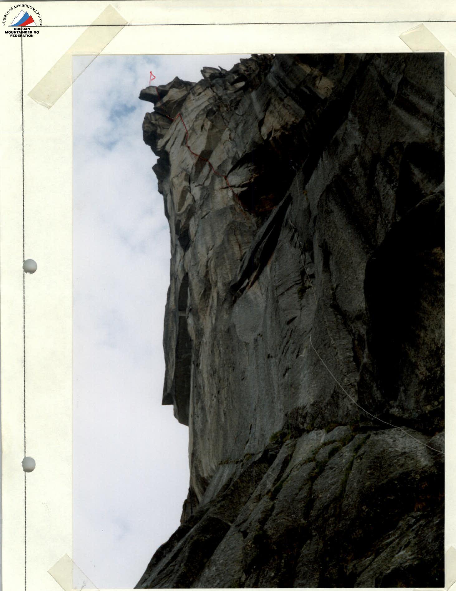
Technical photograph of the route Taken in February 1999.
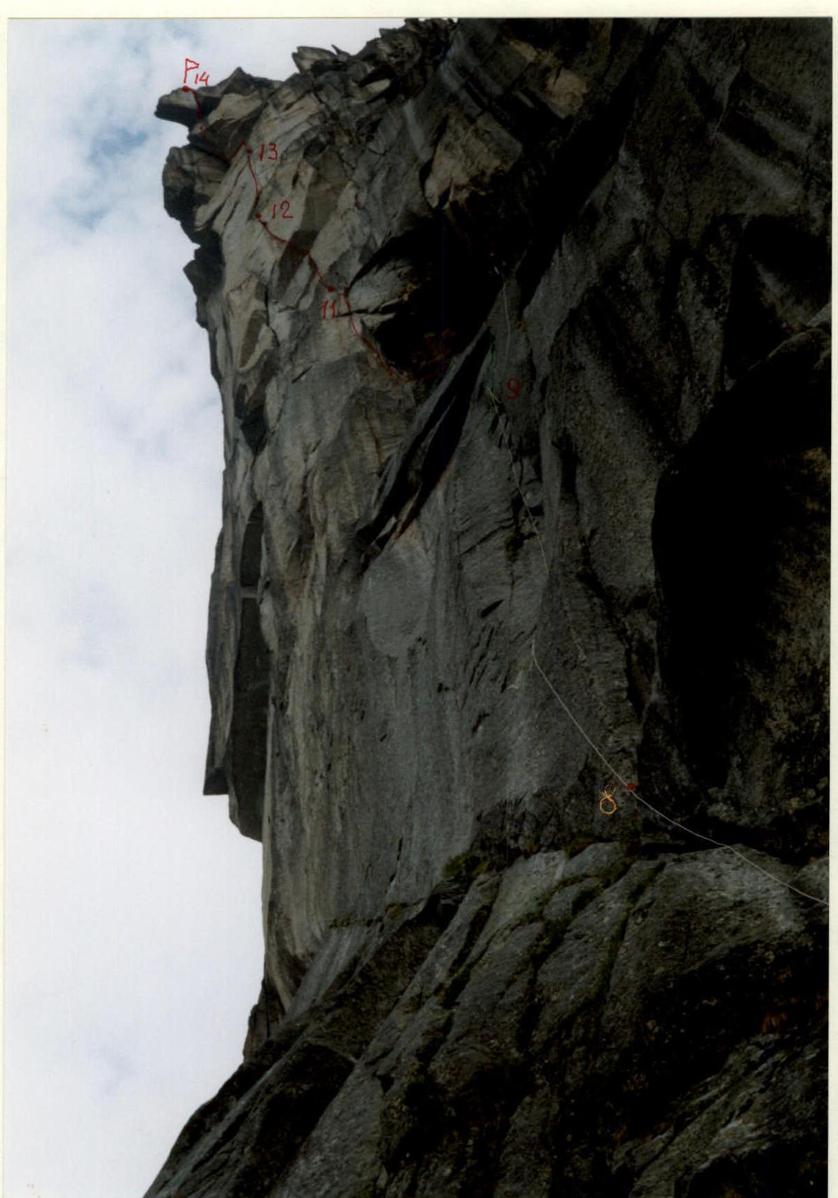
Main part of the route, sections R7–R14 Taken with a "change" from the approach to the first overnight stop.
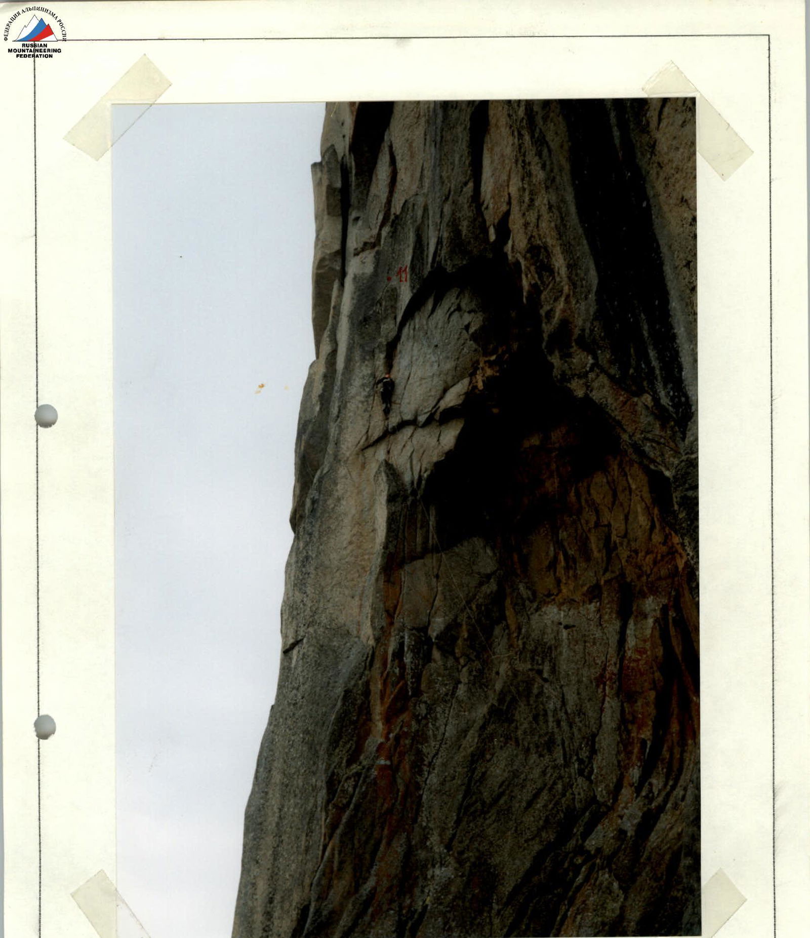
Exit from the grotto, section R10–R11, taken from overnight stop #2.