Passport
- Rock climbing category.
- Western Sayan, Ergaki ridge.
- Zvezdny Peak, 2265 m, via the Northeast wall.
- Proposed 6B category of difficulty, first ascent.
- Route characteristics:
elevation gain 575 m, route length 665 m, length of sections with 5–6 category of difficulty 605 m, average slope 79°.
- Pitons used:
rock nuts bolts ice screws 103/54 214/114 27/17 7/0
- Climbing time 67 hours, total duration 9 days (including acclimatization).
- Overnight stops: 1, 2 – in a tent in a snow-rock grotto; 3 – in a tent on a rock ledge, semi-reclined; 4, 5 – in a tent on a rock-snow ledge.
- Team leader: Balyezin Valery Viktorovich, Master of Sports of Russia International Class
Team members:
- Alexandrov Vladimir Nikolayevich, Candidate Master of Sports
- Bogdanov Vitaly Anatolyevich, Candidate Master of Sports
- Zakharov Nikolay Nikolayevich, Master of Sports of Russia International Class
- Muravyov Vladimir Yuryevich, Candidate Master of Sports
- Obedin Konstantin Alexandrovich, Master of Sports
Team coach: Zakharov Nikolay Nikolayevich
Approach to the route (acclimatization): February 19, 1997 summit: February 27, 1997 return: February 27, 1997
- Team from the Krasnoyarsk Regional Committee for Physical Culture and Sports.
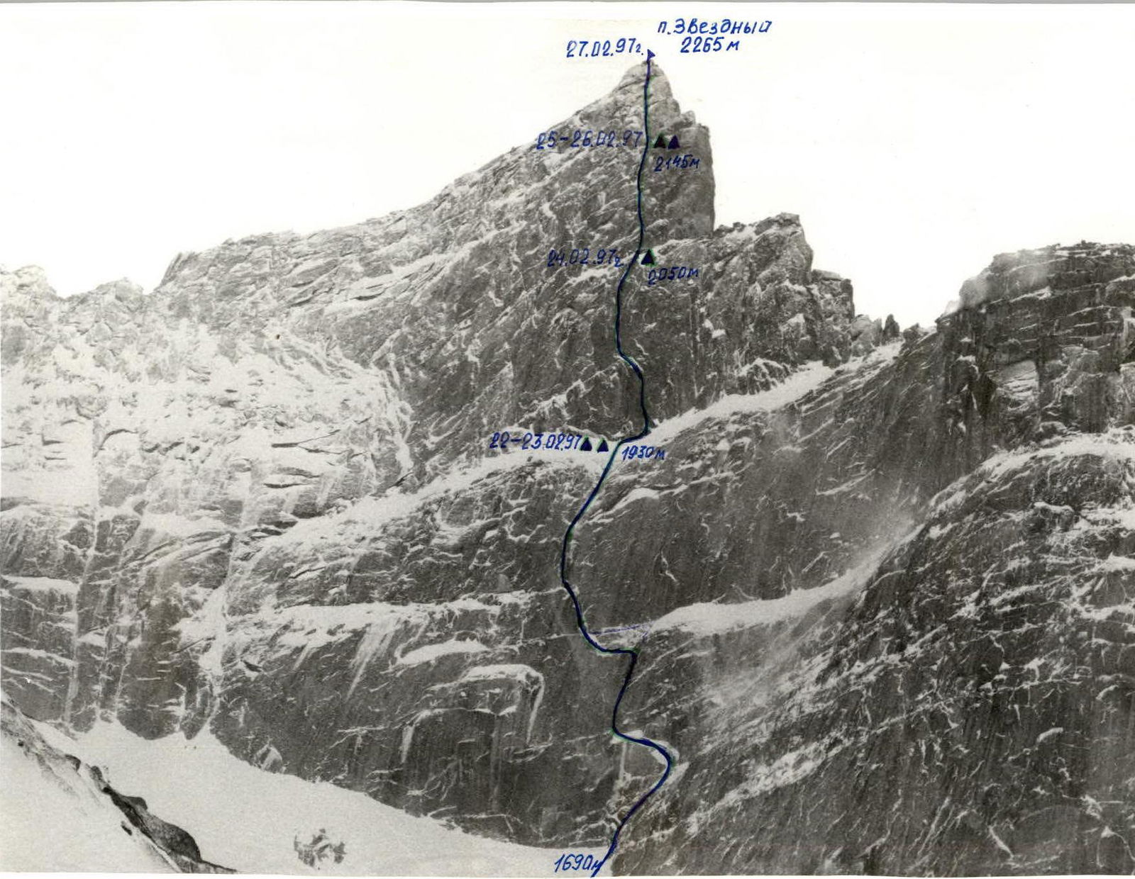
General photo of the summit. Taken on February 18, 1997, at 14:00. "Helios" lens, F=50 mm, shooting height 1700 m, distance 1.5 km. T. 1.
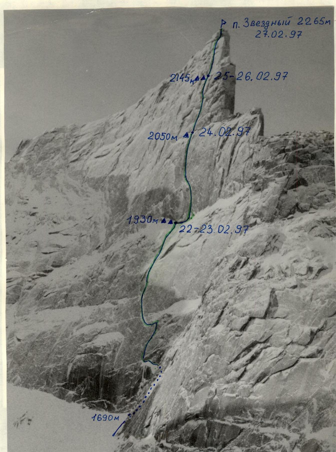
Photo of the wall from the right. "Helios" lens, F=50 mm. Taken on February 28, 1997, at 9:40. Shooting height 1500 m, distance 1.5 km. T. 2.
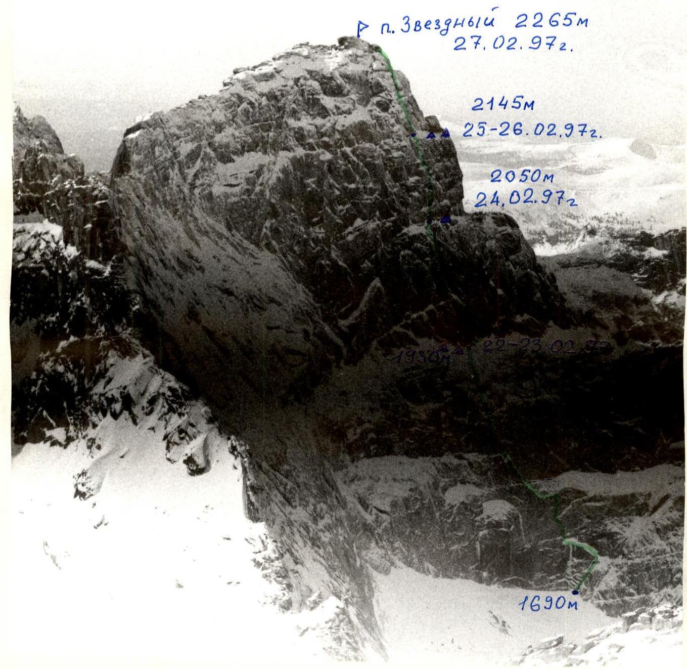
Photo of the wall from the left. "Helios" lens, F=50 mm. Taken on February 15, 1977, at 14:00. Shooting height 2000 m, distance 2 km. T. 3.
Brief Overview of the Climbing Area
The object of the ascent is Zvezdny Peak, 2265 m, located in the Ergaki ridge of the Western Sayan. The climbing area is characterized by an Eastern Siberian mountain taiga climate, known for high precipitation, low temperatures, and strong winds. In February 1997, during the team's training camp and ascent, only two out of twenty days were clear; the rest were marked by continuous snowfall, strong winds, and temperatures ranging from -21 °C to -32 °C.
Access to the climbing object: from Krasnoyarsk to Abakan by bus, train, or plane (about 400 km). Then, by car via the Usinsky tract towards Kyzyl until reaching the intersection with the Tushkanchik river at the 222nd km.
Further:
- From the Tushkanchik river, ski to the shore of Svetloe Lake, located under the southern slopes of Ptitsa and Zvezdny peaks. The distance is about 10 km, taking 4–5 hours. The expedition's base camp was set up here.
- Bypassing the lake from the south, through Lugovoy pass to Zolotarnye Lake.
- From there, along the orographic right bank of the lake to the foot of Pikantny pass, located between Zvezdny and Dinosaur peaks. The pass can be avalanche-prone in winter.
- Through the pass into the North cirque of Zvezdny peak under the Northeast wall. The forward base camp was established here. The path from the base camp is about 15 km, taking around 6 hours on skis.
The Ergaki area, popular among tourists, began to be explored for alpinism in 1995 with a reconnaissance expedition. In 1996, as part of the Krasnoyarsk Region Championship, routes of 4B category on Ptitsa peak and 5A, 5B category on Zvezdny peak from the south were ascended and classified. The North cirques of Zvezdny, Ptitsa, Dinosaur, and Zub Dragona peaks feature unclimbed sheer walls up to 600 m long, suitable for routes of the highest category of difficulty. The peaks include:
- Zvezdny
- Ptitsa
- Dinosaur
- Zub Dragona
- others.
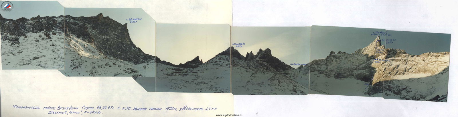
Photopanorama of the climbing area. Taken on February 28, 1997, at 9:30. Shooting height 1500 m, distance 1.5 km. "Helios" lens, F=50 mm.
Tactical Actions of the Team
The first ascent route on Zvezdny peak via the NE wall was completed from February 19 to 27, 1997. The route followed the tactical plan without deviations. Preliminary route processing took three days, followed by the ascent over six days.
On the first day of processing, February 19, the pair Bogdanov–Muravyov covered sections R0–R2; on February 20, Balyezin–Zakharov processed R2–R5; on February 21, Obedin–Alexandrov reached the snow ledge (R7).
The team departed in full on February 22, passing the processed sections and setting up an overnight stop at the end of the ledge (R8). Balyezin–Zakharov continued processing to R9. On February 23, Bogdanov and Obedin reached R11, with the team spending the second night at the same campsite. The next day, they followed the fixed ropes to R11, where a tent was set up on a rock ledge for the night; meanwhile, Balyezin–Alexandrov continued climbing to R12+. On February 25, Zakharov–Muravyov worked ahead, reaching the base of the fifth bastion, where the team set up another overnight stop. On February 26, Obedin and Balyezin processed the route to R15. On February 27, the team, having spent the second night at R13, reached the summit at 11:30. Bogdanov–Alexandrov worked first. The team descended to the forward base camp the same day via the ascent route.
Weather conditions were extreme: daytime temperatures near the forward base camp did not exceed -21 °C, with heavy snowfall and strong winds making the route challenging.
All climbers used crampons while leading, and V. Balyezin used tricouni. Skyhooks were frequently used due to the scarcity of terrain features; ice axes were used on icy cracks. Bolt pitons were often used, mainly for secure belays, especially for fixing ropes.
Overnight stops were set up at planned locations on ledges protected from potential snow cornice and drift fall by overhanging walls and rock cornices.
Meals were organized three times a day, with hot meals for those in the tent; handlers received hot meals in the morning and evening, with dry rations and hot tea from a thermos at noon.
During processing and ascent, the rescue team was stationed at the forward base camp under the wall. Radio communication with the team was maintained using "Alinko" stations; long-distance communication with the Minusinsk rescue service team of the Russian EMERCOM was via a "Kaktus" station through a repeater.
The route was completed securely, with a reserve of physical and moral strength.
Food and Fuel Table
- Roasted meat 2 kg
- Rusks 2 kg
- Sugar 3 kg
- Rice 1 kg
- Buckwheat 1 kg
- Butter 1 kg
- Sausage 3 kg
- Sweets 1 kg
- Soups 1 kg
- Condensed milk 3 kg
- Tea 0.5 kg
- Coffee 0.2 kg
- Lard 1 kg
- Oatmeal 0.3 kg
Total food weight 20 kg, petrol 7 kg, gas 2 kg. Total weight 29 kg. Total weight of team backpacks about 80 kg.
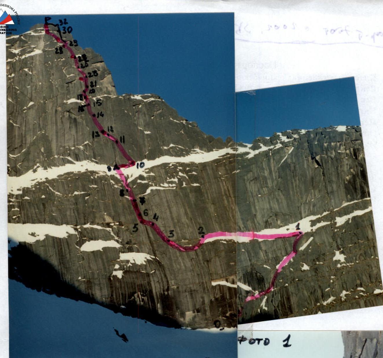
Route Description by Sections
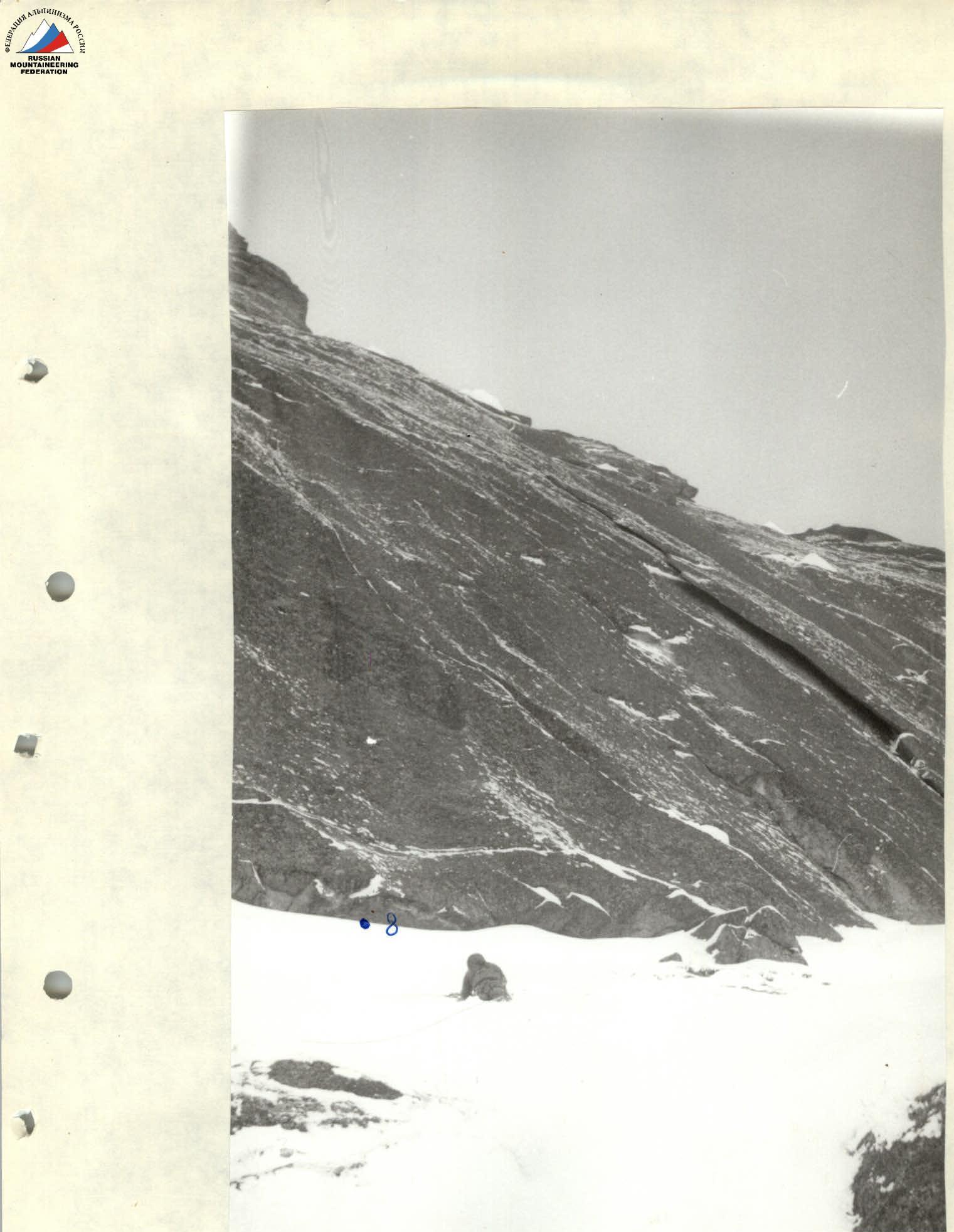
Sect. R0–R1. Internal corner with a wide crack, partially overgrown with grass. Leads to a steep slab-shelf.
Sect. R1–R2. Monolithic slab-shelf under a cornice, iced and snow-covered. Almost no cracks for belay organization. Traverse along the shelf to the left end.
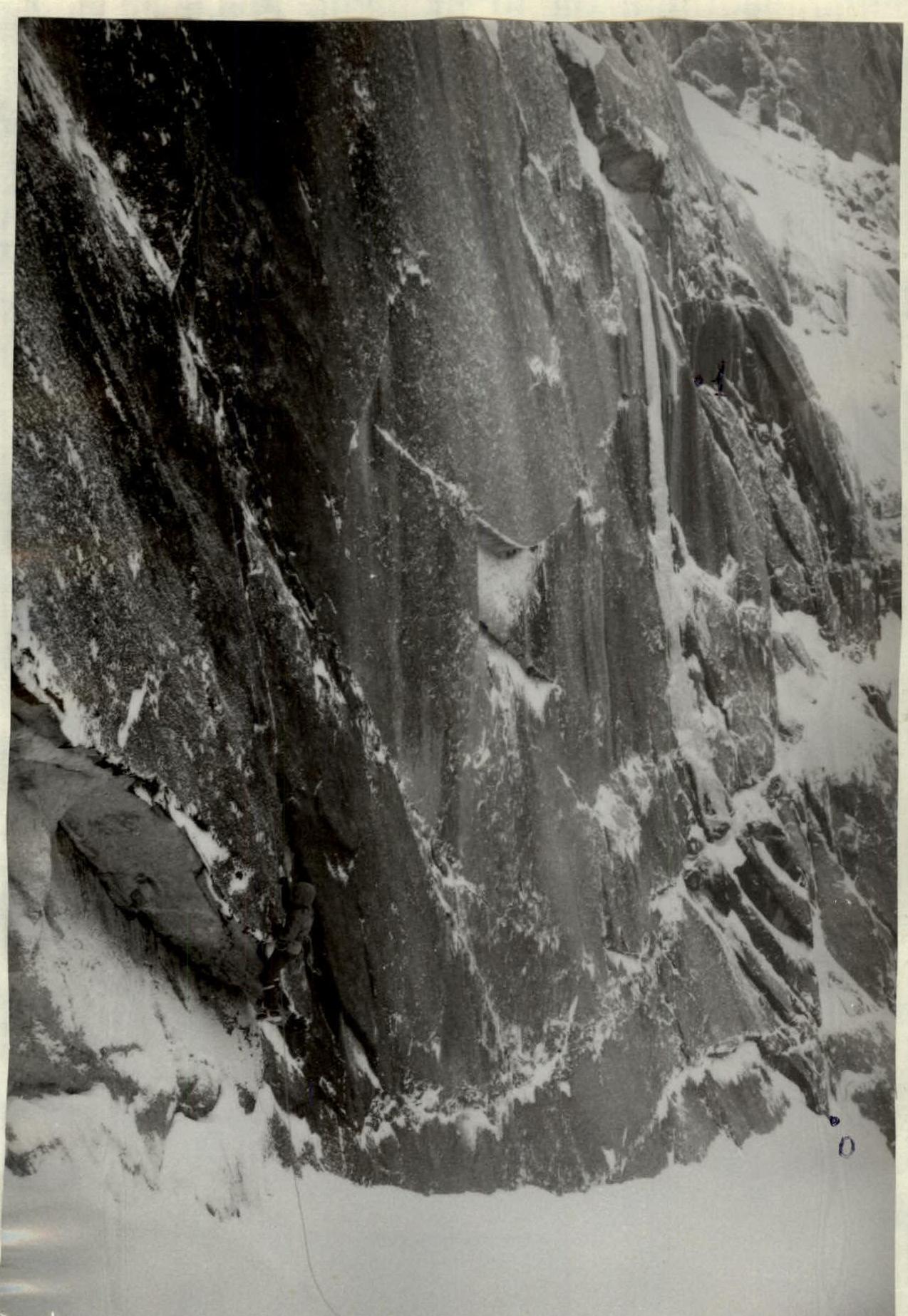
Sect. R2–R3. Monolithic wall with very scarce terrain. At the top, a small internal corner leads to an iced ledge.
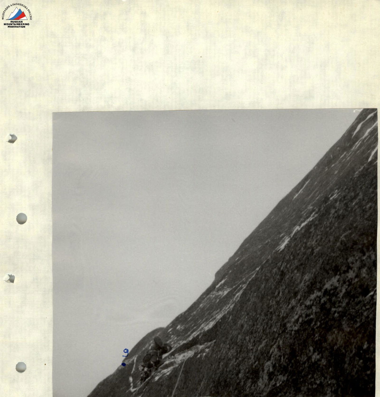
Sect. R3–R4. Traverse left along a series of small iced ledges and walls, partly using pendulum movements, to the start of an internal corner.
Sect. R4–R5. Inclined internal corner leading to a protrusion, then a pendulum to a wall with a crack, up to a ledge where a belay station is set up using bolt pitons.
Sect. R5–R6. Traverse into an internal corner with a wide crack, where large-sized nuts are used. The corner ends in a cornice, bypassed on the right.
Sect. R6–R7. Ice-filled corner turning into a heavily snow-covered chimney, up to the exit onto steep, snow-covered slabs.
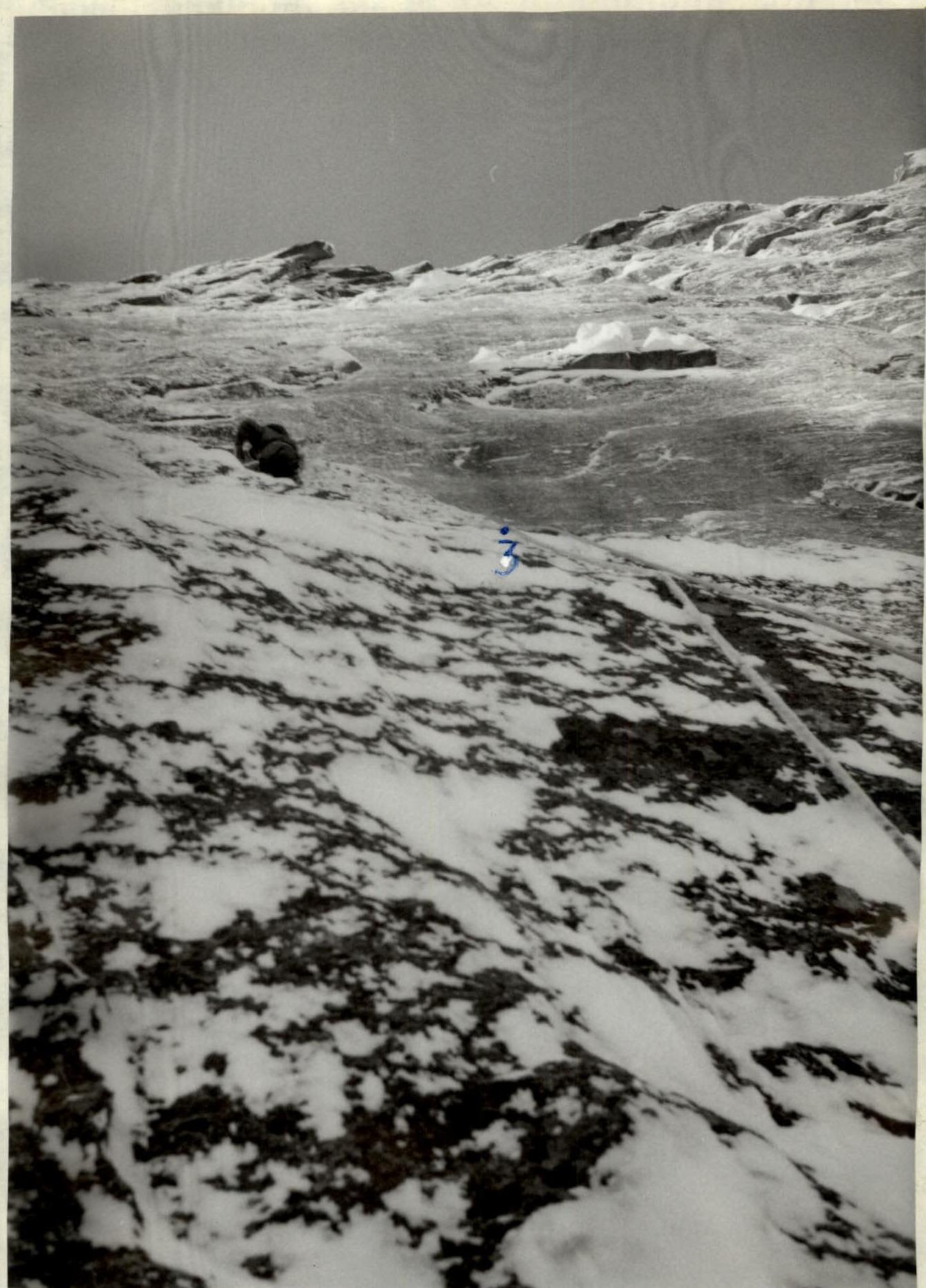
Sect. R7–R8. Steep, snow-covered slab-shelf leading to the base of the third rock bastion. A bolt is placed mid-slab for belay. At the top of the shelf under the cornice, a small grotto is convenient for overnight stay.
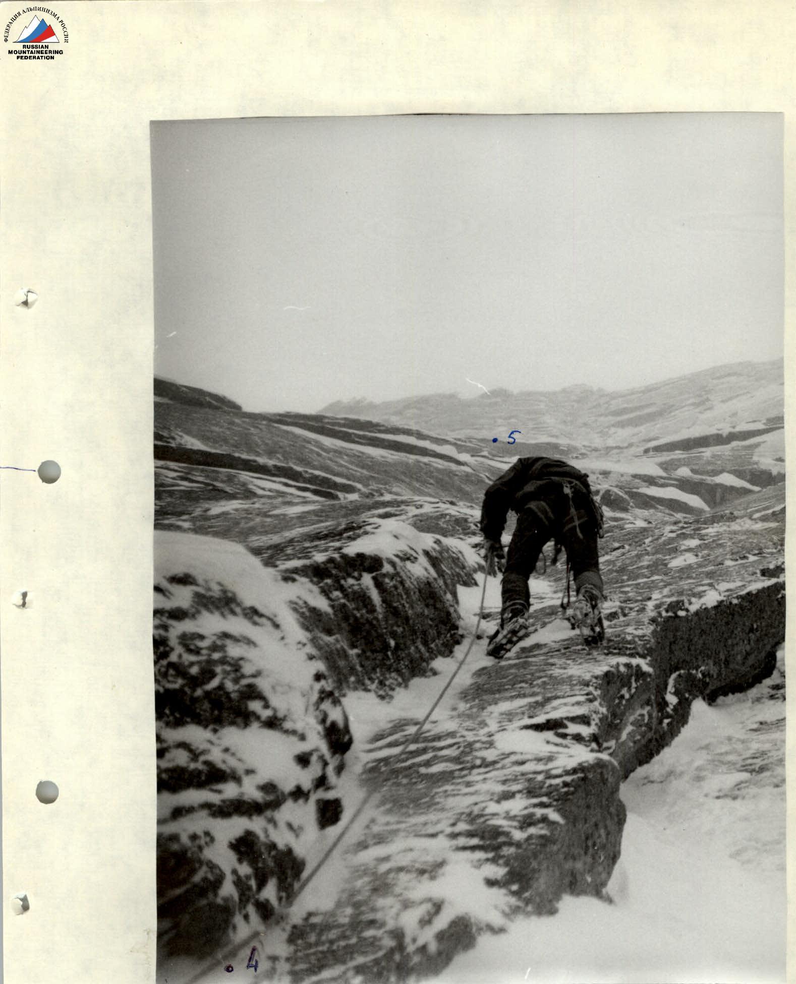
Sect. R8–R9. From the overnight stop, traverse about 10 m to the right, then up an inclined internal corner to the left, turning into a crack. The corner's start is climbed using bolt pitons and skyhooks.
Sect. R9–R10. Steep slab leading into a large internal corner. The slab is covered with flow ice.
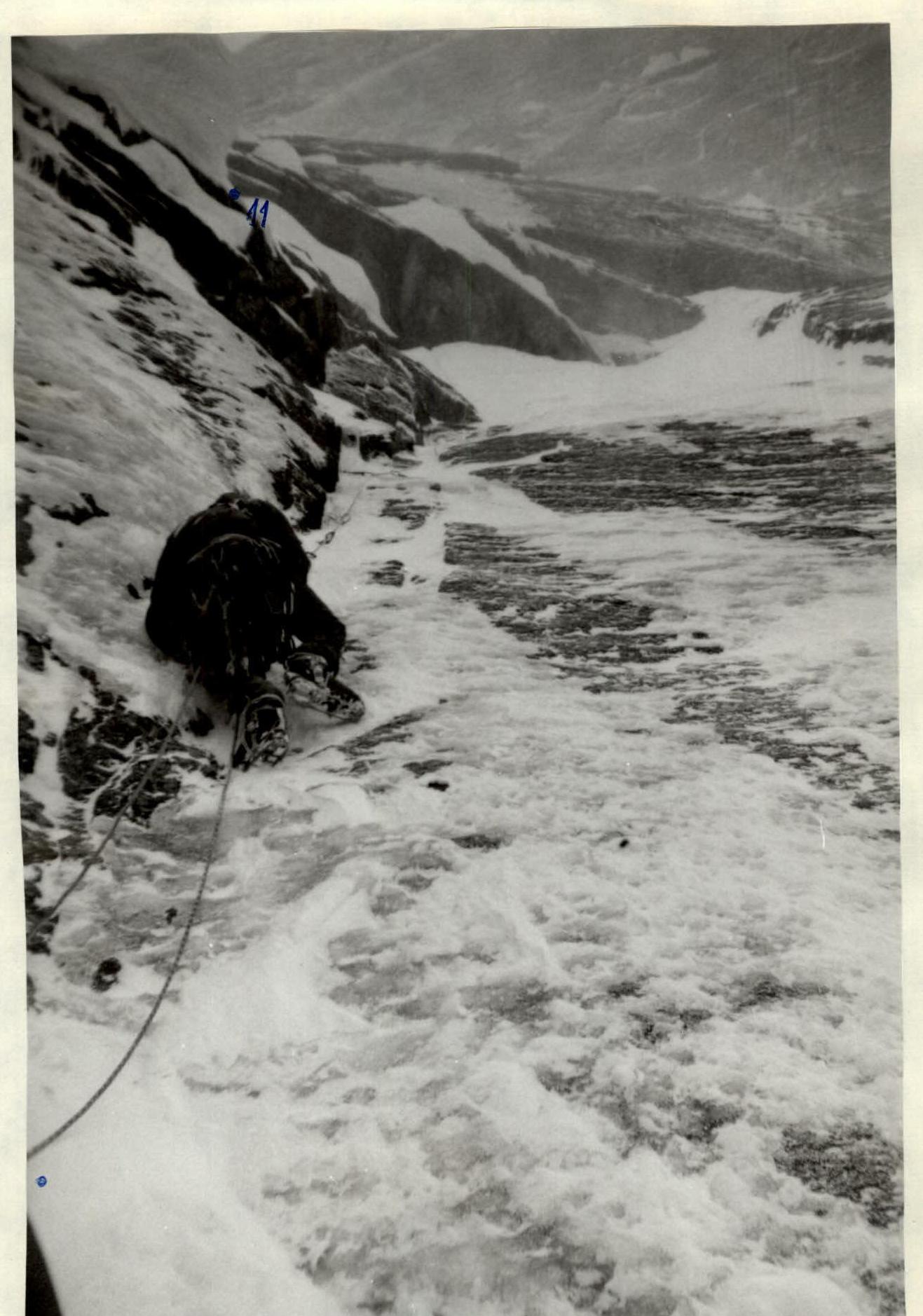
Sect. R10–R11. Internal corner with a cornice at the top, bypassed on the right via a series of small internal corners leading to a ledge under the fourth bastion. Overnight stop on the ledge to the right.
Total: 9 days, 67 climbing hours.
| Equipment | Section Description |
|---|---|
| 214, 103, 27, 17 | Summit on February 27, 1997, time 11:30, climbing time 3 hours, R17. |
| 19, 74. | 30 m, 45°, IV, R16. |
| 26, 14, 5, 3 | February 26, 1997, climbing time 8 hours, 20 m, 85°, VI, R15. |
| 20, 10, 5, 1 | 40 m, 80°, VI, R14. |
| 23, 10, 4. | February 25, 1997, climbing time 7 hours, 40 m, 75°, V+, R13. |
| 21, 15, 10, 5. | February 24, 1997, Overnight #3, 2050 m, 45 m, 90°, VI, R12. |
| 14, 10, 12, 2. | February 23, 1997, climbing time 9 hours, 40 m, 85°, VI, R11. |
| 10, 3, 2, 3, 2. | February 22, 1997, climbing time 9 hours, 40 m, 75°, VI, R10. |
| 11, 10, 15, 6. | Overnight #1–#2, 1930 m, 40 m, 90°, VI, R9. |
| 10, 11, 5. | February 21, 1997, climbing time 8 hours, 30 m, 55°, IV, R8. |
| 5, 5, 4, 1, 4. | 30 m, 70°, V, R7. |
| 17, 10, 5, 3. | February 20, 1997, climbing time 8 hours, 40 m, 80°, VI, R6. |
| 12, 6, 3, 1. | 30 m, 75°, V, R5. |
| 4, 4. | 40 m, 65°, V–, R4. |
| 11, 12, 4. | February 19, 1997, climbing time 6 hours, 40 m, 75°, VI, R3. |
| 7, 6, 3. | 30 m, 75°, VI, R2. |
| 6, 4, 1, 2. | 40 m, 80°, V, R1. |
| 13, 5, 1. | 40 m, 85°, V, R0. |
Sect. R11–R12. Steep crack bypassing the cornice on the right. Skyhooks are used for artificial climbing. The crack turns into an internal corner connecting with a large internal corner. Large nuts are used.
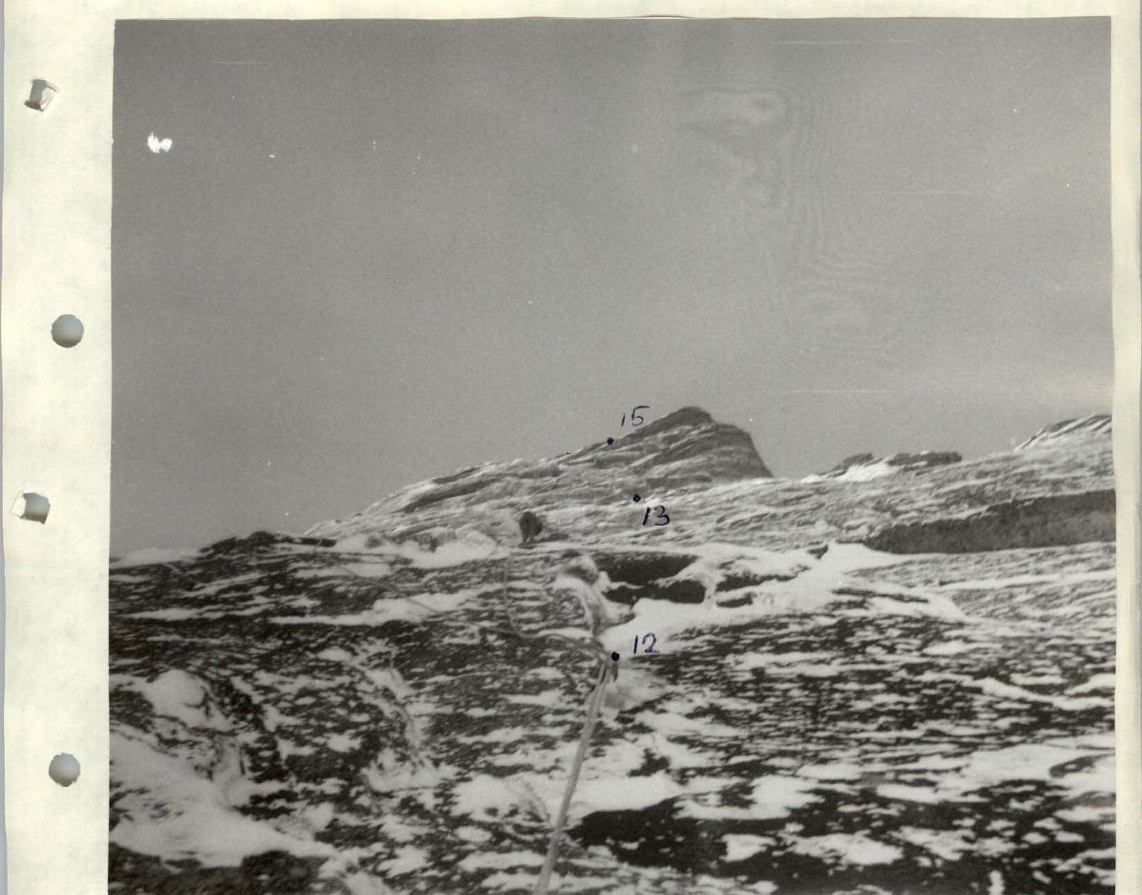
Sect. R., Initially along a large internal corner to the left, then a transition into a vertical chimney. After 20 m, the chimney narrows into a crevice leading to a ledge under the fifth bastion. Overnight stop on the ledge.
Sect. R13–R14. Large internal corner-split, partly with a wide snow-filled crack. At the top, it turns into a vertical crack.
Sect. R14–R15. Crack crossing two cornices, turning into an internal corner leading to the pre-summit shoulder.
Sect. R15–R16. Steep 20-meter wall with a crack, climbed using artificial aids, leading to the pre-summit ridge.
Sect. R16–R17. Pre-summit ridge, heavily snow-covered rocks.

Technical photograph of the route. Taken on February 28, 1997, at 9:00. Shooting height 1700 m, distance 1.5 km. "F=60 mm" lens.
Start of the route. Movement along simplified ropes.
Start of traverse R3–R4.
Inclined internal corner R4–R5.

Traverse into an internal corner R5–R6. Snow is lying!
Approach to the overnight stop.
Movement along R8–R9 using artificial climbing aids.
Movement along sect. R10–R11. Approach to overnight stop R11.
Upper part of the wall.
"Oro 1"