
Ascent passport to the peak Trekhglavaya (C — N) 2557 m, via Eastern couloir, traverse, cat. 2A. Eastern Sayan, Tunkinskie Goltsy range, Kyngarga valley, section 6.1. 2. Peak Trekhglavaya (C — N), 2557 m, via Eastern couloir, traverse. 3. Proposed cat. 2A, first ascent. 4. Route character — combined. 5. Height difference 300 m, length 1400 m, average steepness 25°. 6. Pitons: rock and wired 5 pcs. 7. Team's moving hours — 7 h. 8. No bivouacs on the route. 9. Team: Afanasiev S.A. III grade, Afanasiev A.E. MS. 10. Coach — Afanasiev A.E. MS. 11. Ascent to the peak and return on May 1, 2001.
Description of the ascent route to the peak Trekhglavaya (C-N) 2557 m via Eastern couloir, traverse, cat. 2A.
This route is the reverse traverse of the classified route 2B cat. of the S — C Trekhglavaya traverse, starting with the ascent via S ridge. This route starts from the descending couloir of eastern exposure between the peaks Southern and Central Trekhglavaya. Here is the descent from all routes to the Southern and Central peaks of Trekhglavaya, and sometimes people descend after ascending to the Northern Trekhglavaya. Along the couloir — 500 m, 35° — snow covered scree. Sometimes it is avalanche-hazardous. The upper part of the couloir is located in the narrow rocky jaws of the Southern and Central towers and snow here some years persists till the end of summer.
Section R0–R1 60 m. 45° I+ Upper part of the couloir. On the bridge snow corniche up to 2 m. Ropes.
Section R1–R2 350 m. 60° II− Ascent to the Central tower of Trekhglavaya can be done by two variants:
- first one via Southern ridge, three rope lengths, 4 rock pitons;
- second — left of the ridge via descending path, one-two rope lengths.
This section is the key one for the route 1B cat.
Section R2–R3 150 m. 50° II+ Descending from the vertex tower partly by climbing and in three cases descending by sport rope descent for 10–15 meters.
Section 3–4, 180 m. I+ Traverse of almost flat ridge with two low gendarmes between Central and Northern towers of Trekhglavaya. First gendarme is passed along the ridge. Second gendarme is passed left of the ridge.
Section 45, 100 m. 55° I+ Vertex tower of Northern Trekhglavaya. First along the scree on the left, then along the monolithic large rocky blocks. Exit to the summit.
Descent to the north via route 2B cat. 200 m with three sport rope descents for 10–15 meters till the connection with eastern counterfort. Further descent can be continued via NE couloir. Above it there are many loose rocks, it is advisable to clear them for the safety of the below located descending couloir.
In case of increased avalanche danger:
- if it was not possible to trigger the avalanche, it is necessary to continue along the Northern ridge of route 2B;
- when descending via couloir it is necessary to move alternately with safety rope attached to rocks;
- total length of descent — about 700 meters.
As a third option: it is possible to descend via the ascent path.
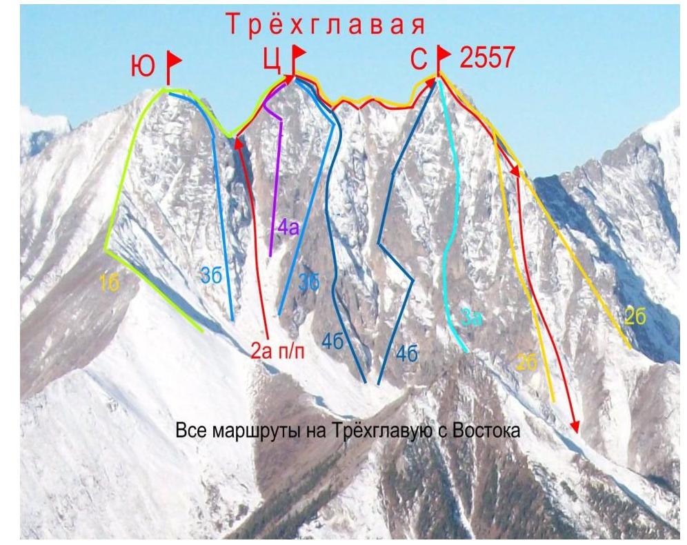
All routes to Trekhglavaya from East.
Comments
Sign in to leave a comment