56a
Route Description
on the East face of the Central Spire of TRÈKHGLAVAIA Peak (2511 m).
Group composition: Leader B. M. Belousov, V. M. Kharlamov, N. K. Laptev, Z. M. Boyarkina.
Ascent dates: May 5-7, 1972. The group departed from the base camp, located at the forest boundary (≈1700 m), at 6:00 AM towards the lower part of the Central Spire's wall.
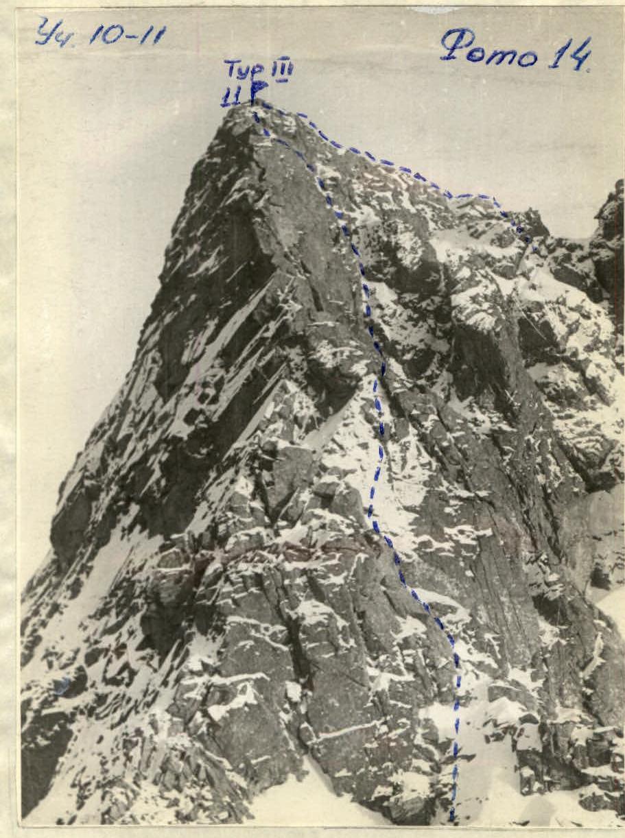
The approach to the route's starting point takes 40-50 minutes. The route begins approximately 60 meters to the left and above the wall's lowest point, which transitions into scree without flattening. See photos 1, 3.
The R0-R1 section follows a small counterfort protruding from the wall, with heavily fragmented rocks. See photo 3. Insurance is set up alternately through ledges. Be cautious of numerous loose rocks. The slope's steepness is 50°. Monolithic rocks follow oblique shelves, transitioning into an ascent to the upper part of this protruding counterfort. At the top of this section, the group changed from crampons to "vibram" boots.
Brief Geographical Overview
of the TRÈKHGLAVAIA Peak area, travel to the area, and approach to the base camp.
The TRÈKHGLAVAIA Peak area is located in the eastern part of the Tunkinskie Belki ridge in the Eastern Sayan Mountains. The ridge stretches clearly from west to east for 150 km and approaches the southwestern tip of Lake Baikal. Streams and rivers flowing from the ridge flow into:
- On the southern side - into the Irkut River;
- On the northern side - into the Kitoy River.
Travel from Irkutsk is by bus to the Arshan resort, from where cargo can be transported to the Kynargi River gorge only on foot or by helicopter.
From the Arshan resort, a worn path leads up the Kynargi River gorge along steep cliffs and rocks initially, then opens into a widening valley. At the valley fork, there is a taiga winter hut. The travel time with cargo from Arshan to the winter hut at the river fork (see map) is 4-5 hours.
From the winter hut, follow the path for about an hour (along the right orographic tributary), then turn left into the gorge, where the TRÈKHGLAVAIA Peak massif comes into view. There is no path here, and it's better to follow the stream's edge, as the slopes are densely overgrown with forest and bushes and are difficult to traverse.
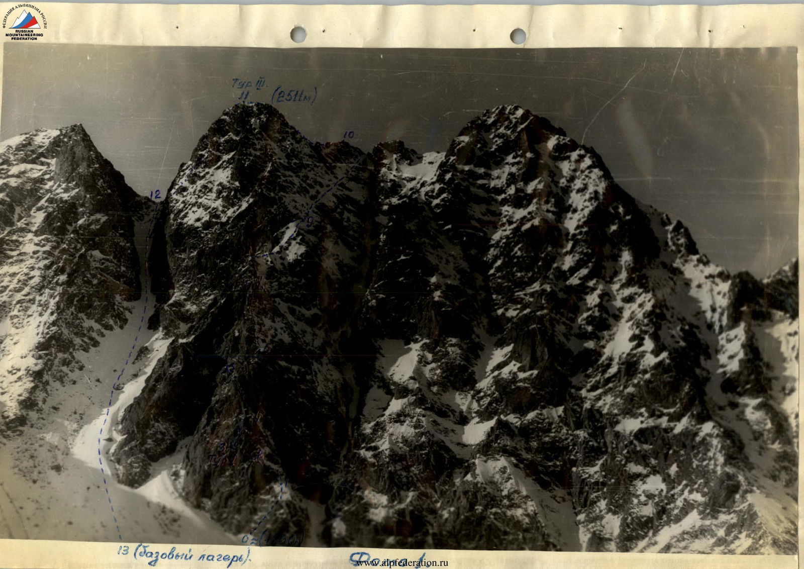
13 (base camp)
From the ridge of the wall counterfort, move upwards along monolithic rocks of medium difficulty, interspersed with fragmented sections. The rocks are covered in snow. At point 2, insurance can be set up and ropes attached to protruding boulders. From this point, the group switched to pulling backpacks up using a rope, as climbing with a load became very challenging.
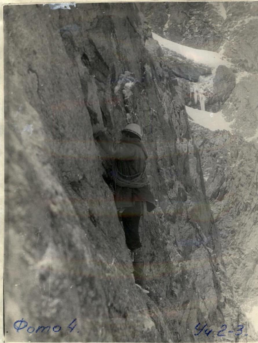
Scree sections gave way to a monolithic wall with few holds. See photo 4.
After ascending 12 meters, it's necessary to veer left and exit into a crevice 10-12 cm wide, sloping upwards to the left.
After 10-14 meters, two boulders protruding from the wall, up to 2 meters high, are encountered. Insurance is organized through them.
Continue along the same crevice, transitioning into a crack, and exit onto a balcony that can accommodate four people standing. Here is landmark No. 1, a can inserted into the crevice at chest level. Nearby, there are no similar platforms or balconies.
From point 2, it's not possible to go straight to point 4 (see photo 2), as the wall above takes on a negative angle. From the balcony, the route goes upwards along vertical small angles with a slight inclination to the right and again exits onto the right edge of the wall triangle, adjacent to icy and smooth slabs lying on the northern side of the wall.
This section is characterized throughout by a powerful monolith with weak fissures and holds. See photo 5. Climbing here is very difficult and requires the use of artificial support points in some places.
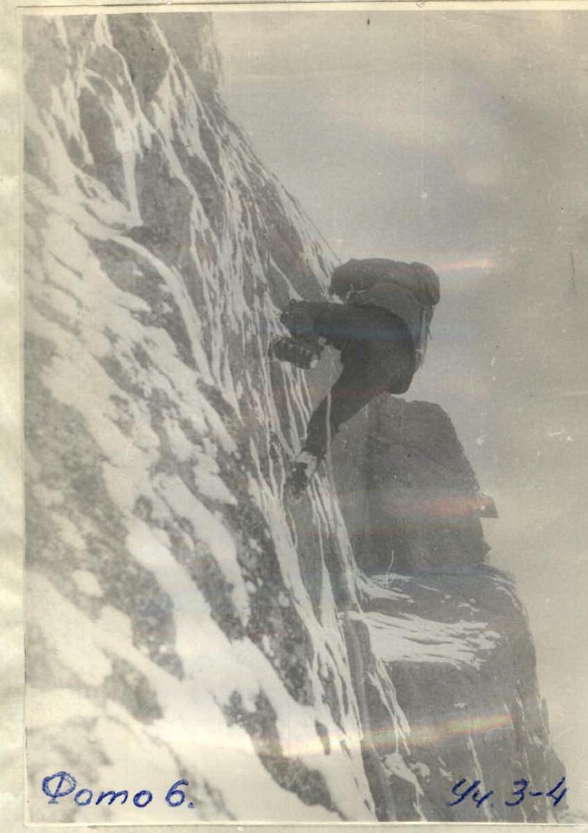
The first rope team managed to pass this spot in good weather, after which a light snowfall occurred, and the rocks became difficult to traverse even on fixed ropes. See photo 6.
For those following, it's advisable to use sliding clamps instead of a Prusik knot, as there are instances of pure vertical rope climbing.
Passing this section of the route, with even a slight amount of snow, will require the lead climber to:
- Hammer in numerous pitons;
- Use artificial support points such as ladders and platforms.
In the upper part of this section, a ledge 1 × 2 meters is encountered, and 8-10 meters above, another ledge suitable for a semi-reclined bivouac for 4 people.
Minimal holds must be searched for under the fallen snow; frequently, it's necessary to:
- Use a teammate for support;
- Hammer in pitons for artificial support points.
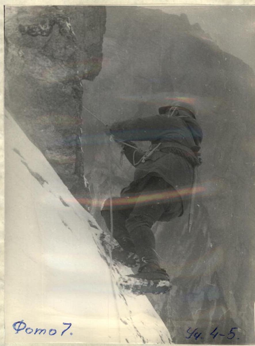
The R4-R5 section lies exclusively on the right edge of the wall and represents a steep monolithic wall with minimal holds. See photo 7.
This section is traversed with complex climbing and piton insurance. The key moment of the section, and indeed the entire route, is passing a sheer rock belt 5-6 meters high. See photos 2, 8. Here, the lead climber used ladders (to pass the rock belt).
Cracks are only suitable for hammering in blade pitons, and on a 2-meter section, there are no cracks even for them.

For insurance and passing this spot, it was necessary to use two drilled pitons. To the left and right of this spot are vertical walls without holds or cracks, with a slight overhang.
Climbing to and after the sheer belt is also very difficult. Minimal holds are covered in snow, and to find them, it's necessary to clear every protrusion and depression.
Above the sheer belt, the route goes:
- Vertically upwards;
- Along old rock faces;
- Along walls.
At the top of the wall (point 5), the route exits onto a wide ledge-platform, inclined slightly to the left. Here, the first bivouac is organized. A tent can be set up, but movement across the ledge requires fixed ropes, as the surrounding area is sheer.
The first day's route was completed in 10 hours of work.
From the bivouac site, the route turns right between large monoliths-boulders.
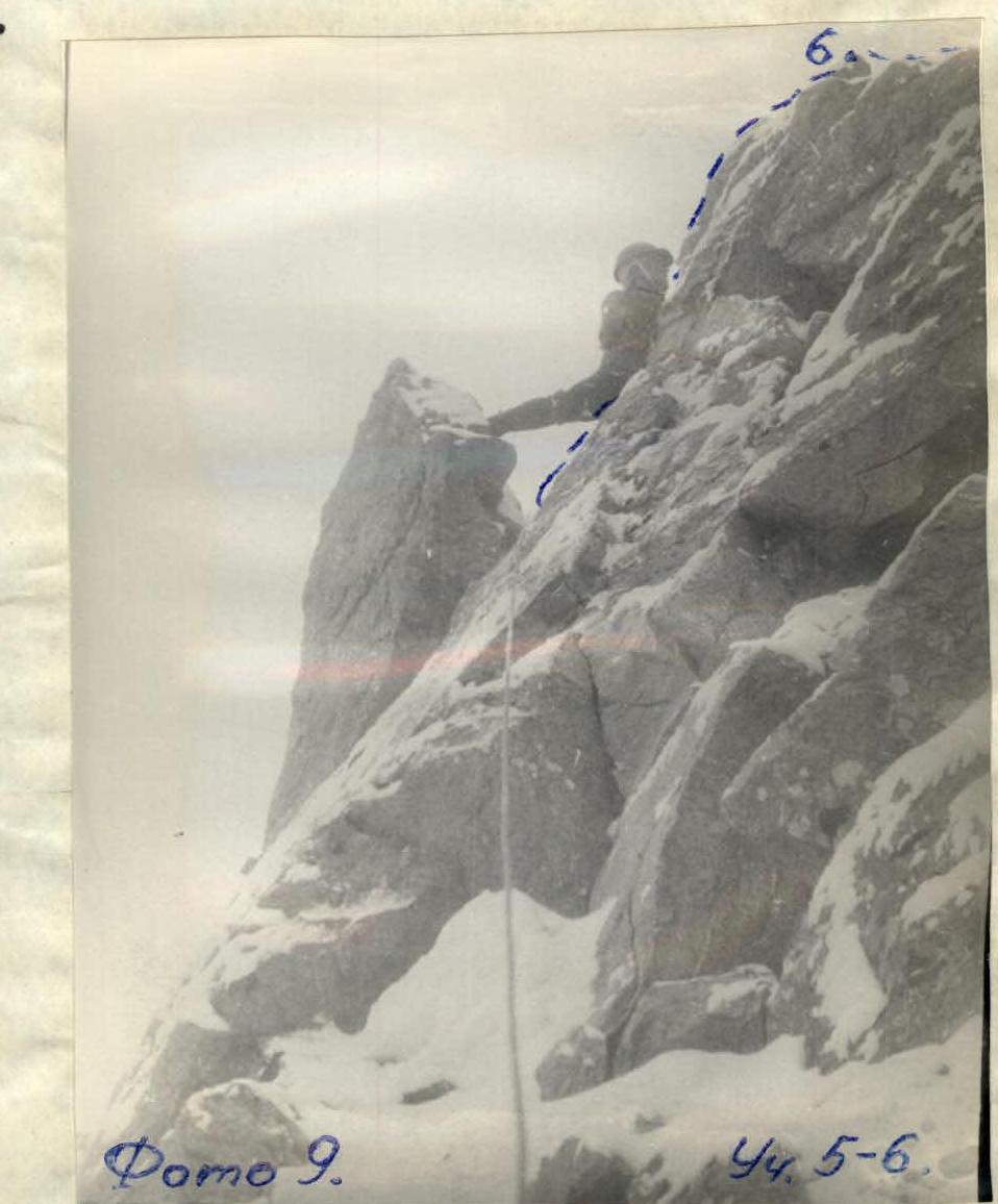
The R5-R6 section is traversed easily with alternate insurance and is not far from the edge of the vertical wall (see photos 2, 9) until it exits onto the right slope of the further ridge. From here, the route turns left onto the ridge itself and follows it.
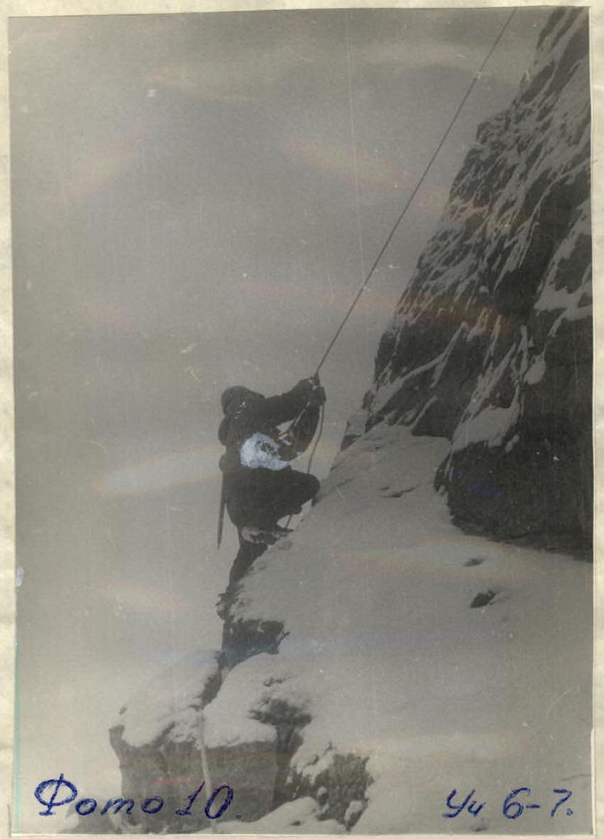
The entire ridge requires medium-level climbing, alternate insurance through pitons and ledges, or fixed ropes. See photo 10. To the left, the ridge drops off with a vertical wall; to the right, there are inclined slabs with ice and snow. It's recommended to follow the ridge's edge, which is steep and quite sharp but has many holds.
The ridge leads to a gendarme (landmark No. 2), from which it's necessary to descend 20-25 meters into a narrow saddle 0.5 meters wide. The descent is along boulders with alternate insurance through a protrusion on the upper point of the gendarme. Bypassing the gendarme is much more difficult:
- To the left - a wall;
- To the right of it - steep slabs.
From the saddle, it's necessary to climb straight into the wall towards the ridge, staying about 3 meters from the left edge of the wall (to the left is the drop). The exit is complicated by the wall's steepness of 60° with few protrusions and holds, snow, and ice. Pitons must be hammered in only after clearing the wall of ice and snow. Ice pitons cannot be used, as the ice crust here is only up to 3 cm thick.
After exiting onto the horizontal ridge, the route is easy and straightforward. Insurance is mostly simultaneous, and only some sections of the sharp ridge are traversed with alternate insurance. Approximately 200 meters after exiting onto the ridge, it widens and becomes steeper. The left slope of the ridge meets a wall, and the right slope transitions into the general slope of the entire peak massif. See photo 1, section R8-R9.
At the end of the ridge, a bivouac is organized with a tent set up on a wide, inclined snowfield. The site is not prone to rockfall.
The working time on the second day was about 8 hours. The further route was planned and traversed along a clearly defined snow cornice, departing from the second bivouac site upwards to the right along the right slope of the peak massif.
Section:
- R9-R10
The snow cornice lies on slabs with a 40° slope, with outcrops of icy rocks above and below it. It's traversed throughout the length of the snow cornice with alternate insurance through ice axes and pitons hammered into rock outcrops. In the snow and névé, it's necessary to:
- Kick steps;
- Trample steps.
See photo 2.
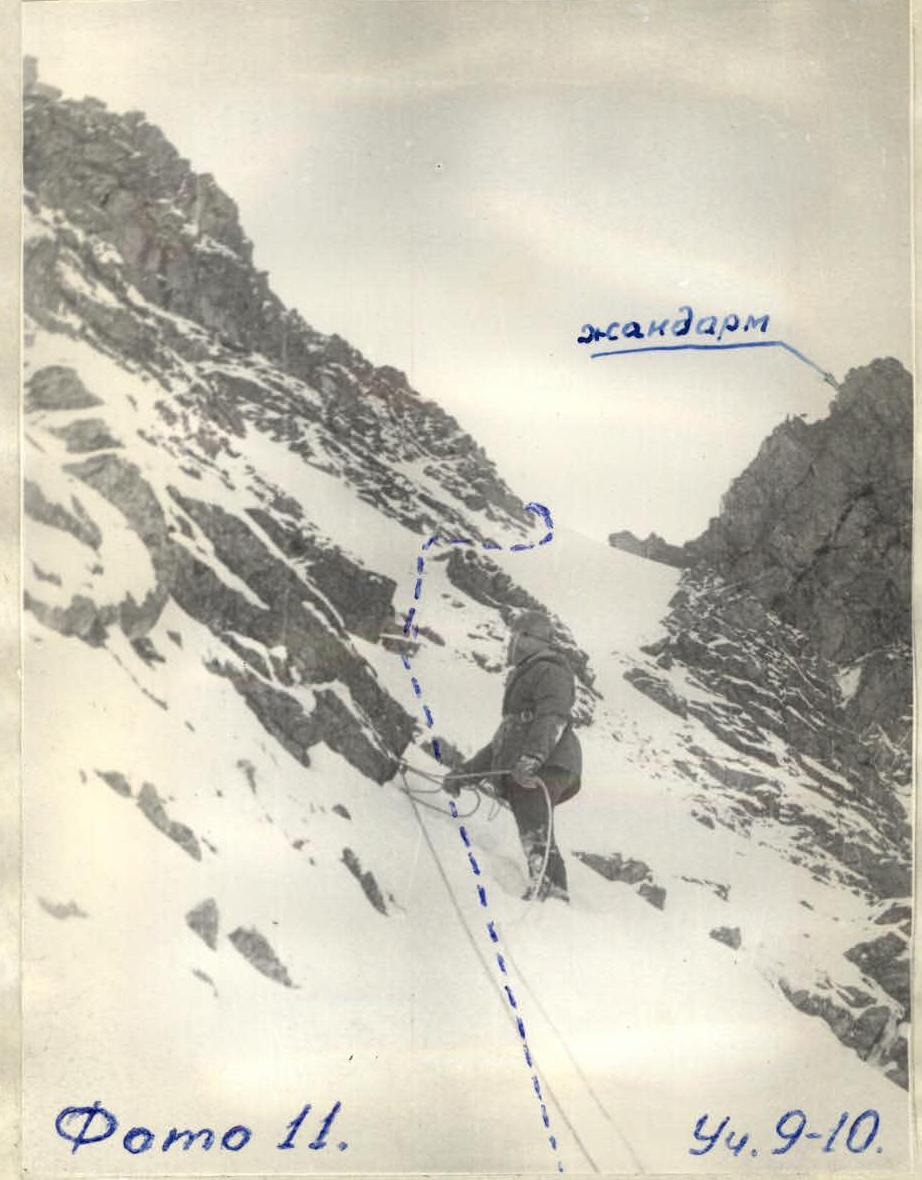
On this section, it's necessary to maintain a direction to the left of the gendarme located on the main ridge between the North and Central peaks of TRÈKHGLAVAIA. See photo 1. At the end of the snow cornice, it's necessary to exit steeply to the left - upwards onto the main ridge, connecting the peaks. Here, the slope's steepness reaches 45°. See photo 12. Directly in front of the gendarme lies a drop with steep slopes. The steep exit upwards is equal in distance to one rope length. Insurance is alternate through a piton-carabiner.

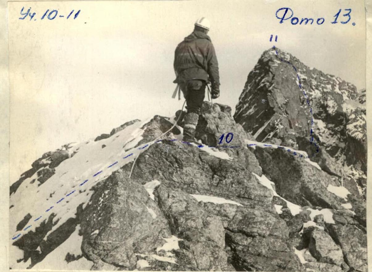
After exiting onto the main ridge, this route follows the route of category 2B complexity. From the exit from the snow cornice (see photo 13), it's necessary to go initially slightly down the ridge, then, staying somewhat to the right and below the main ridge, upwards to the summit of Central TRÈKHGLAVAIA.
This section of the route is traversed easily, with the overcoming of small walls of medium difficulty before the summit. On the summit, the final control landmark No. 3 is located. It's worth noting that traversing the main ridge is hindered by constantly blowing winds in the spring-autumn period. The air temperature dropped to -12 °C.

The descent also follows the route of category 2B complexity. Initially down to the saddle between the Central and South peaks of TRÈKHGLAVAIA (see photo 1), then down a steep canyon to the base camp. See photo 15.
- The upper part of the canyon is hard névé;
- The lower part is soft snow;
- The upper part is traversed with alternate insurance through an ice axe.
The time on the third day of the ascent was 9 hours of work.
TOTAL TIME SPENT - 27 hours of work. TOTAL PITONS HAMMERED:
- Rock pitons - 41 pieces;
- Blade pitons - 2 pieces;
- Drilled pitons - 2 pieces.
Weather conditions throughout the entire route were good.
Recommendations for Climbers
- Group composition - no more than 4-6 people.
- In dry weather, everyone should wear "vibram" boots, and the "lead climber" - overshoes.
- Have a wide range of rock pitons and 6-8 drilled pitons.
- Have ladders or platforms (especially in wet weather or with snow on the rocks).
- Have two ice axes or ice hammers.
- Have a good rock climber in the group.
The group assesses the traversed route in terms of length, difficulty, and conditions as a category 4B complexity route.
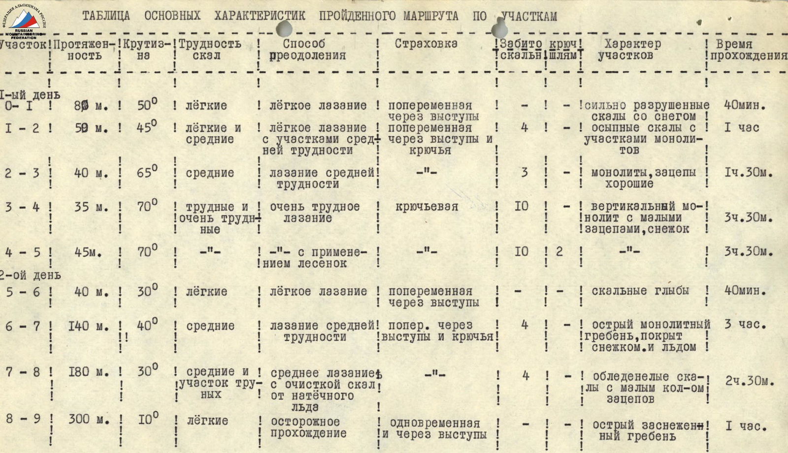
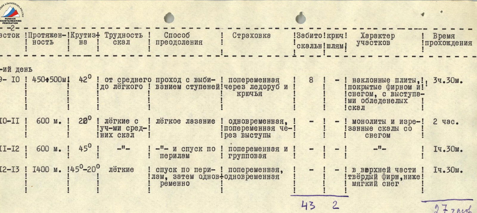
TABLE OF MAIN CHARACTERISTICS OF THE TRAVERSED ROUTE BY SECTIONS
| Section | Length | Steepness | Difficulty on rocks | Method of overcoming | Insurance | Pitons hammered (rock/drilled) | Character of sections | Time taken |
|---|---|---|---|---|---|---|---|---|
| 1st day | ||||||||
| R0-R1 | 80 m | 50° | easy | easy climbing | alternate through ledges | 4 | heavily fragmented rocks with snow | 40 min |
| R1-R2 | 50 m | 45° | easy and medium | easy climbing with sections of medium difficulty | alternate through ledges and pitons | 4 | scree rocks with sections of monoliths | 1 h |
| R2-R3 | 40 m | 65° | medium | climbing of medium difficulty | - | 3 | monoliths, good holds | 1 h 30 min |
| R3-R4 | 35 m | 70° | difficult and very difficult | very difficult climbing | piton insurance | 10 | vertical monolith with minimal holds, light snow | 3 h 30 min |
| R4-R5 | 45 m | 70° | - | - with the use of ladders | - | 10/2 | - | 3 h 30 min |
| 2nd day | ||||||||
| R5-R6 | 40 m | 30° | easy | easy climbing | alternate through ledges | - | rock boulders | 40 min |
| R6-R7 | 140 m | 40° | medium | climbing of medium difficulty | alternate through ledges and pitons | 4 | sharp monolithic ridge, covered in snow and ice | 3 h |
| R7-R8 | 180 m | 30° | medium and difficult | medium climbing with clearing rocks of ice accretion | - | 4 | icy rocks with minimal holds | 2 h 30 min |
| R8-R9 | 300 m | 10° | easy | cautious passage | simultaneous and through ledges | - | sharp snow-covered ridge | 1 h |
| 3rd day | ||||||||
| R9-R10 | 450-500 m | 42° | from medium to easy | passage with step-kicking | alternate through ice axe and pitons | 8 | inclined slabs covered in névé and snow, with outcrops of icy rocks | 3 h 30 min |
| R10-R11 | 600 m | 20° | easy with sections of medium rocks | easy climbing | simultaneous, alternate through ledges | - | monoliths and fragmented rocks with snow | 2 h |
| R11-R12 | 600 m | 45° | - | - and descent on ropes | alternate and group insurance | - | - | 1 h 30 min |
| R12-R13 | 1400 m | 15-20° | easy | descent on ropes, then simultaneous | alternate, simultaneous | - | upper part - hard névé, lower - soft snow | 1 h 30 min |
| TOTAL | Total: 47 rock / 2 drilled pitons | 27 h |