
Ascent Passport
- Ascent class — rock
- Ascent area — Eastern Sayan, Tunkinskiye Belki ridge
- Peak, its height — v. SOAN, 2952 m, ascent route — South wall
- Assumed category of difficulty — 5B
- Route characteristics:
- Height difference — 652 m
- Length of sections with 5–6 category of difficulty — 515 m
- Average steepness of main sections — 72°
- Pitons hammered for insurance to create artificial support points:
- Rock — 184
- Ice — 7
- Bolt — 6
- Number of travel hours — 42
- Number of overnight stays, their characteristics:
- 3 overnight stays: 2 sitting, 1 lying down
- Full name of leader, participants, and their qualifications:
- SHILONOSOVA T.A. — leader, 1st sports category
- BELOUSOV V.M. — participant, CMS
- SHVAB A.E. — participant, CMS
- LARIN V.N. — participant, CMS
- SHILONOSOV G.V. — participant, CMS
- Team coach — BELOUSOV V.M.
- Date of departure on the route — May 3, 1977
- Date of return from the route — May 6, 1977
Team captain:
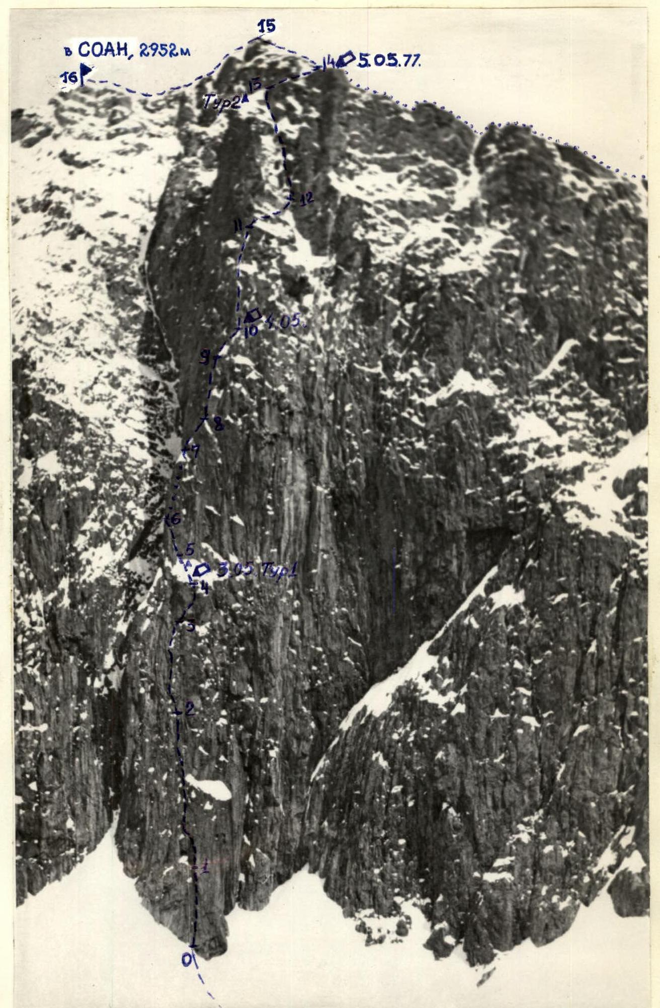
Route Profile

Map of the SOAN peak area (2952 m)
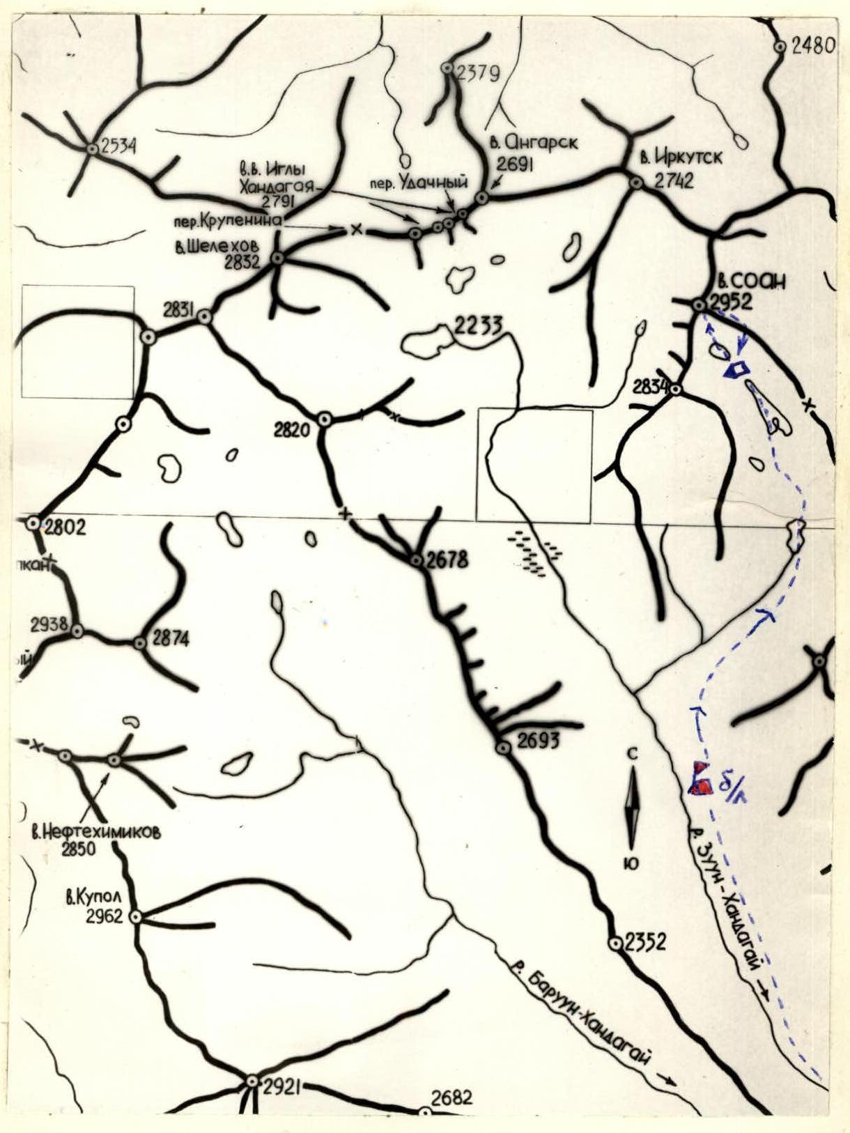
Legends
- Base camp
- Assault camp, group overnight stays
- Group's route path
Photo 1
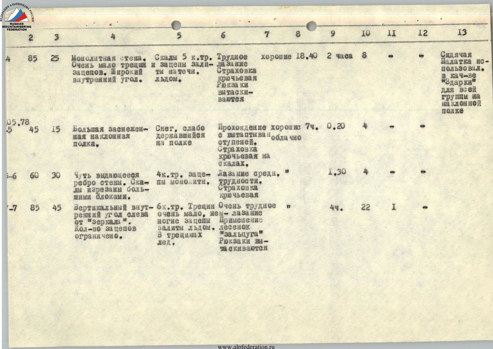
Route Sections Table
| № | Avg. steepness | Section length | Section characteristics and passage conditions | Time | Pitons driven | Overnight conditions |
|---|---|---|---|---|---|---|
| **By relief | By technical complexity | By way of overcoming and insurance | By weather conditions | |||
| 3.05.78 | ||||||
| R0–R1 | 70° | 50 m | Monolithic wall in the form of a counterfort. The corners of the rocks are smoothed out. | Difficult rocks, 5 category of difficulty. Few holds and cracks, iced over. | Difficult climbing. Piton insurance on a double rope. Holds cleared of rime ice. | good |
| R1–R2 | 75° | 90 m | Monolithic wall with a vertical zigzag crack. Small ledges. | Rocks of 5 category of difficulty. Holds are few but strong. Ledges in snow, cracks iced over. | Difficult climbing. Piton insurance. Insurance points on small ledges. | good |
| R2–R3 | 75° | 60 m | Monolithic wall without ledges. | Rocks of 5 category of difficulty. Few holds and cracks, and those are iced over. | Difficult climbing. Use of ladders. Rucksacks pulled up by rope. | * |
| R3–R4 | 85° | 25 m | Monolithic wall. Very few cracks and holds. Wide internal corner. | Rocks of 5 category of difficulty, and holds are iced over. | Difficult climbing. Piton insurance. Rucksacks pulled up. | good |
| 4.05.78 | ||||||
| R4–R5 | 45° | 15 m | Large snow-covered inclined shelf. | Snow, weakly held on the shelf. | Passage with stepping on steps. Piton insurance on rocks. | good |
| R5–R6 | 60° | 30 m | Slightly protruding edge of the wall. Rocks are cut by large blocks. | 4 category of difficulty. Monolithic holds. | Climbing of medium difficulty. Piton insurance. | * |
| R6–R7 | 85° | 45 m | Vertical internal corner to the left of the "mirror". The number of holds is limited. | 6 category of difficulty. Very few cracks, some holds are iced over. Ice in cracks. | Very difficult climbing. Use of ladders "zaltsuga". Rucksacks pulled up. | * |
| R7–R8 | 65° | 30 m | Short steep edge of the wall, with small steps-shelves. Rocks are monolithic. | 5 category of difficulty. | Difficult climbing from shelf to shelf. Piton insurance. | * |
| R8–R9 | 80° | 40 m | Monolithic wall. Very few cracks, and they contain ice. Small cornices. | 6 category of difficulty. Holds are strictly limited. Wall is smoothed out. | Very difficult climbing. Use of ladders "zaltsuga". Pulling up of participant with rucksack due to cornices. | * |
| 5.05.78 | ||||||
| R9–R10 | 60° | 25 m | Monolithic wall on the left is absolutely smoothed out, on the right — with small ledges. | 5 category of difficulty. Ledges are iced over and covered with snow. | Free climbing from ledge to ledge to the right and upwards. Clearing of ledges from snow and ice. Piton insurance. | * |
| R10–R11 | 75° | 70 m | Monolithic wall with flat flakes. In the upper part, a large flake on the left and small ledges. | 5 category of difficulty from flake to flake. Holds are limited. | Difficult climbing with piton insurance. Rucksacks pulled up. Holds are strong. | good |
| R11–R12 | 50° | 30 m | Inclined snow-covered slabs with inclined ribs. | 4 category of difficulty. Very few cracks for pitons. Snow slides off the slabs when loaded. | Careful passage. Piton insurance under the overhanging wall on the left. Entering the snow-covered internal corner. | * |
| R12–R13 | 65° | 70 m | Vertical internal corner. Snow-covered and iced over. Leads to a short ridge. | 5 category of difficulty. Holds and cracks in snow and ice. | Difficult passage with clearing of holds and piton sites from ice and snow. Snow and ice fall down the corner. | * |
| R13–R14 | 35° | 50 m | Short snow ridge with a vertical wall of 10 m. The ridge connects to the southeast ridge of the peak. | 4 category of difficulty. Few holds and cracks on the wall for pitons. | Loose, crumbly snow. The wall is passed with difficult climbing. | * |
| 6.05.78 | ||||||
| R14–R15 | 25° | 89 m | Narrow monolithic ridge, consisting of smooth slabs and blocks, small walls. | 3 category of difficulty. Cracks and niches with transverse pitons, covered with snow and ice. | Medium climbing. | Light fog |
| R15–R16 | 10° | 300 m | Narrow ridge, consisting of blocks and sharp monoliths. Further towards the peak, the ridge becomes talus and turns into a large scree on the peak. | 2 category of difficulty. Ridge is covered with snow. | Easy climbing. Insurance is alternating and simultaneous. | * |
| Descent along the southeast ridge by route 3B category of difficulty | ||||||
| * |
Approach to the Route Description
The SOAN peak (Siberian Branch of the Academy of Sciences) is located in the southern spur of the Tunkinskiye Belki ridge in the Eastern Sayan. To the left and right of v. SOAN are the sources of mountain streams Talta and Zuun-Khandagai, flowing south to the r. Irkut.
In alpinist terms, the most developed is the Zuun-Khandagai river gorge, which has a lateral branch at the forest boundary, going left.
It is more convenient to set up a base camp at the forest boundary, just below the confluence of the gorges, due to the large amount of firewood needed in the conditions of low temperatures in the Sayan in April-May. From the confluence, it is necessary to ascend up the left (orographic) gorge, bypassing three high-mountain lakes. See the map.
It is more convenient to set up an assault camp on the saddle between the third and fourth lakes under the south wall of v. SOAN on flat areas. The level of the lake under the wall is 2200 m. From the lake to the wall, there is a talus slope rising 100 m, covered with snow. The route along the south wall begins immediately from the talus slope between the central and right snow cones.
The path from the base camp at the forest boundary to the assault camp under the south wall of v. SOAN takes 3 hours.
Brief Description of the Route by Sections
May 3, 1978. Section R0–R1
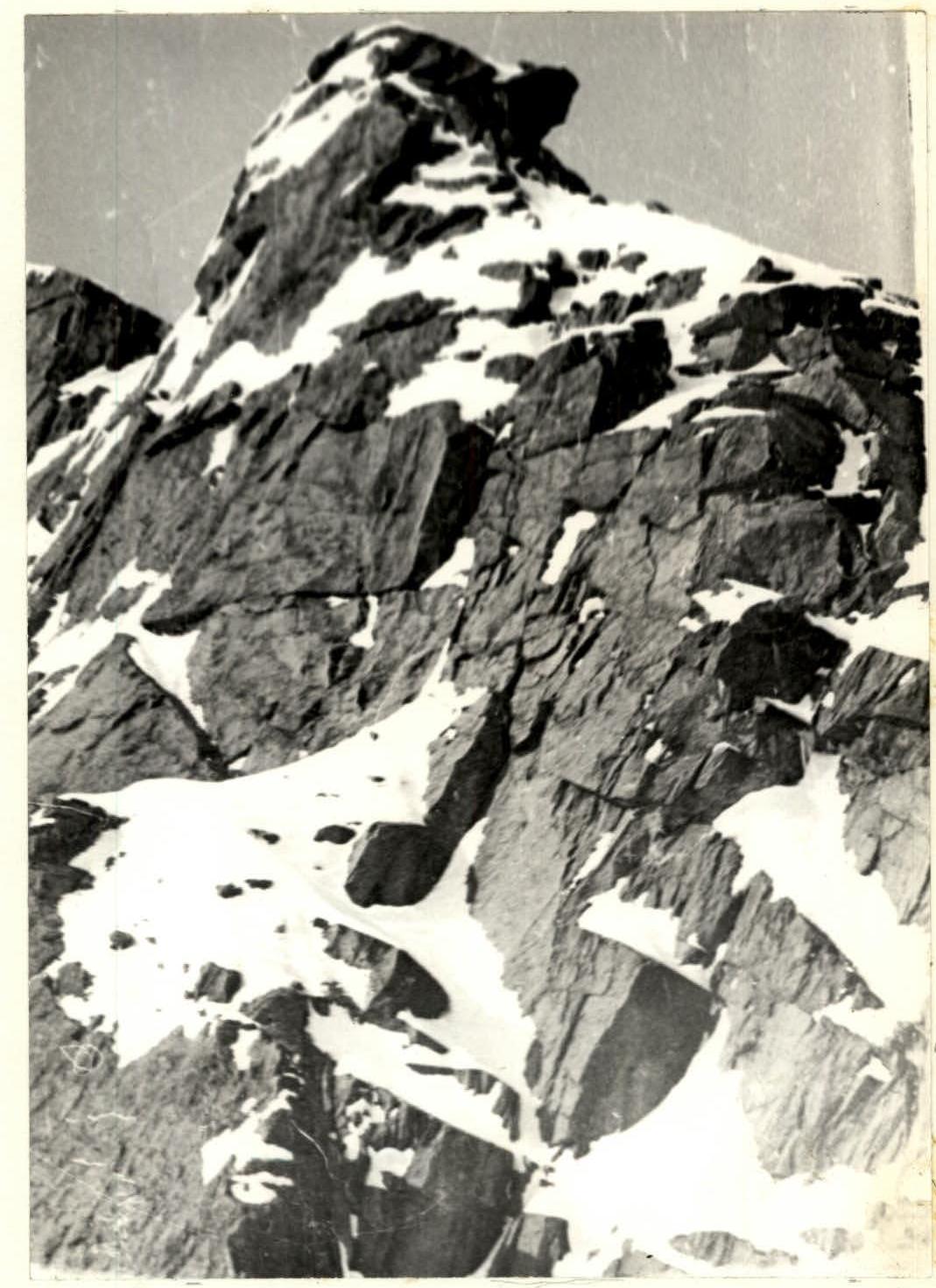
From the lower point of the unclear counterfort, located between the central and right snow cones, ascend left along the snow along the wall for 20 m. From here, move upwards along difficult rocks, following a slightly noticeable wide rib of the counterfort. The wall is monolithic. There are few holds and cracks, and most are iced over. See photo 3. Corners and ledges are smoothed out. Holds are monolithic but need to be cleared of rime ice and snow. Insurance is organized with pitons. Travel pitons are 4 mm thick: vertical, combined, and box-shaped. Small ledges are covered with frozen earth from above. The first in the group goes without a rucksack and in galoshes, the rest — in "vibram" boots.
Section R1–R2
After a small inclined ledge (one person can stand), a zigzag crack with small ledges goes upwards. It is necessary to move along it. See photo 4. The steepness increases slightly. Holds along the crack are few but strong. Accidental rockfall is excluded. Insurance points are organized on small ledges with snow on them. Insurance is fully piton. Climbing with a rucksack is possible only along the ropes with pulling up the rucksack from above. All the time, move towards the left edge of the large snow shelf above. Holds need to be cleared of ice. Cracks are often iced over. In some places, it is necessary to drive ice pitons like VTsPS into the cracks.
Section R2–R3
The zigzag crack ends, and further upwards, a small internal corner begins, not noticeable from below. The route is absolutely vertical and goes along a monolithic wall with ledges — no more than for one foot. The direction remains the same — towards the left edge of the snow shelf upwards. Climbing is difficult. Ladders are hung to organize insurance points and receive rucksacks, which are pulled up. There are few holds and cracks for pitons. There is rime ice in the cracks. Insurance is organized for the entire group on a double rope.
Section R3–R4
The route passes under the left part of the protruding wide nose, on which there is an inclined snow shelf. Under the nose, there is also a snow "bowl" that remains on the right along the path under the overhanging rocks. To the left of the nose is a wide internal vertical corner. Move along it along the monolithic wall. Holds and cracks are limited. Climbing is difficult. Not reaching the edge of the snow, it is necessary to go up to the right along the inclined cornice and reach the edge of the shelf. See photo 5.
In the upper part of the section, climbing is very difficult. Rucksacks are pulled up on this section.
Throughout the sections of the first day of ascent, a monolithic wall went through, holds are strong, there are no loose rocks. The snow shelf has a slope of 45°, snow is loose, and the depth is small. Under the snow is monolith. It is impossible to make a flat area for a tent, so a semi-reclining overnight stay is organized. A "Pamirka" was used as a collective bag-tent under "Zdarka". A cairn 1 is built on a protruding rock.
May 4, 1978. Section R4–R5
Along a significant inclined shelf, go to the left upper corner towards the protruding short edge of the wall. Above the center and right part of the shelf, the wall is more vertical and has many cornices. See photo 6. Snow on the shelf is loose, poorly compressed. Under the snow are monolithic rocks. To pass the shelf, perils are stretched across its entire width.
Section R5–R6
Along rocks of medium difficulty, move left and upwards along a slightly protruding edge of the wall. Rocks are cut into large blocks by cracks. See photo 7. Holds are monolithic. It is necessary to approach under the left edge of the rock "mirror" located above. There are enough cracks for driving pitons. Wedge-shaped and box pitons are used well. Rocks are monolithic. There are no loose rocks.
Section R6–R7
From the base of the rock "mirror", go to its left edge around the corner. Here, the route goes along a vertical internal corner. Key section. Very difficult climbing with the use of ladders and passage "Zaltsug". Cracks in the corner are iced over. There are very few holds. See photo 8. Some rucksacks are pulled up, and some are pulled up with participants. The insurance point is organized in a hanging position on ladders. To the left of the corner are even more complex rocks with overhanging cornices, and to the right is a smooth wall of the "mirror" without cracks and holds. Passing this section took about 4 hours, so with a different tactical plan, it should be considered as the main one on this route.
In the upper part of the corner, there are overhanging monolithic blocks that need to be bypassed on the left and reached.
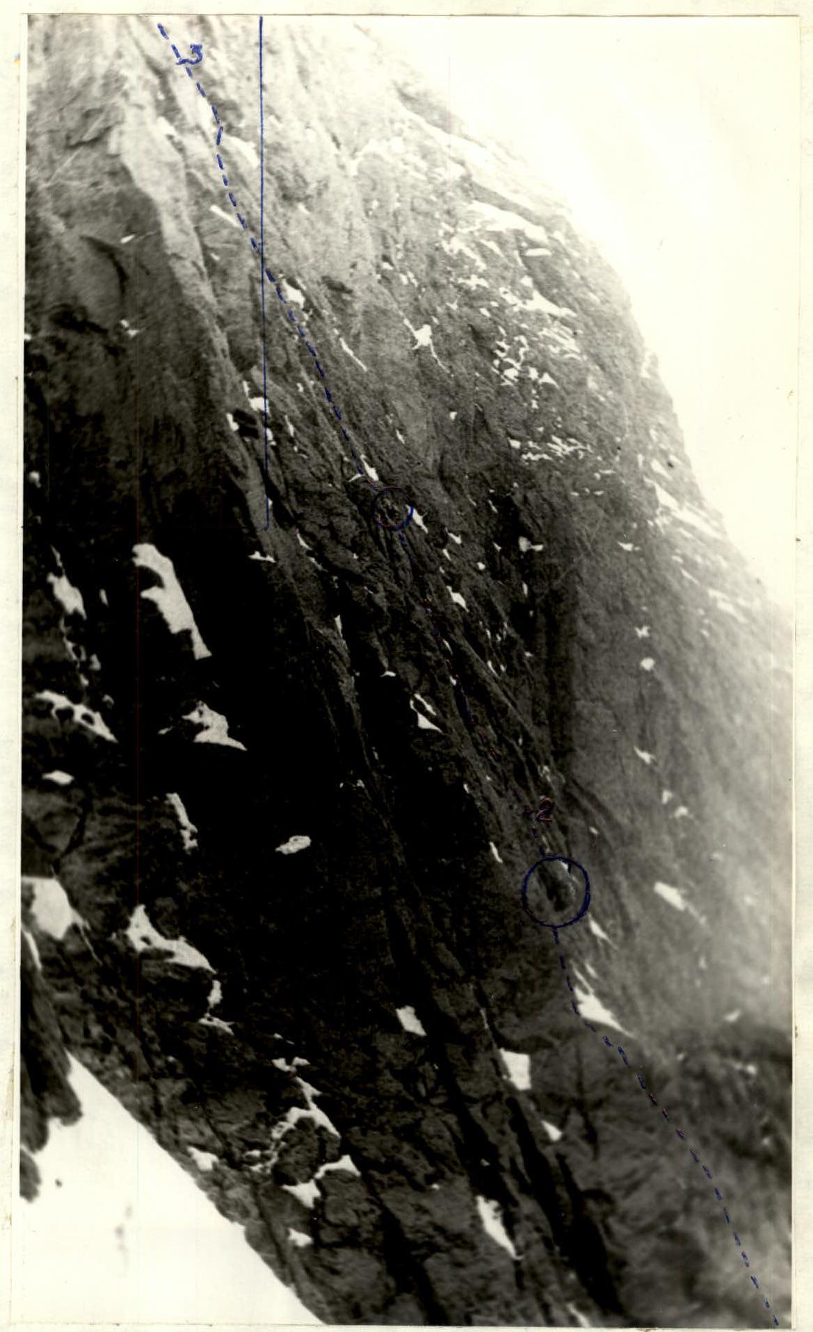
Section R7–R8
The "mirror" ends with a small shelf covered with snow at the top. See photo 2. The route reaches here after passing the vertical corner. Above the shelf, there is a wall that is passed with difficult climbing. After 6–8 m, there is another shelf, smaller. Then again, a wall of 12 m and a small ledge. The entire route, starting from the snow shelf, goes along the edge: the left side of which breaks off with a wall into the central groove and faces west; and the right side is turned to the south. Rocks are all monolithic, few holds are strong. It is necessary to clear holds of ice and ledges of snow. Movement along the walls is hindered by a thin layer of ice covering some sections of the route.
Section R8–R9
After one of the small ledges, the edge sharply increases in steepness. See photo 9. Rocks become absolutely monolithic. There are very few cracks, and they contain ice. There are several small cornices. The general movement is along a wide edge between the western and southern walls. Climbing is very difficult. Ladders are used to pass cornices. Due to cornices that prevent pulling up rucksacks, participants are pulled up with rucksacks. The entire wall is smoothed out — without any protrusions or ledges. This is also one of the key sections of the route.
Sections of the wall above which there is at least a little snow are covered with a thin layer of ice. With a slight warming by the sun, this crust melts, and the rocks become wet and equally difficult to pass.
Section R9–R10
The wall becomes slightly more gentle: on the left — smooth and breaks off into the central groove, on the right — goes more gently and with small ledges. There is snow with ice on the ledges. The route along the edge deviates slightly to the right. When passing this section, it is necessary to clear holds and ledges of ice and snow. Insurance is everywhere only with pitons. Climbing from ledge to ledge is difficult.
A sitting overnight stay is organized solo on ledges 0.5×1 m, as there are no visible ledges above. There is a slight fog in the air — a harbinger of a not very cold night.
May 5, 1978. Section R10–R11
After small ledges covered with snow, the wall again increases in steepness. Above, a clearly visible overhanging corner of the edge is visible. The general direction is towards it. The wall is monolithic, in the lower part has flat flakes. See photo 10. Climbing is difficult with piton insurance. Initially, from flake to flake, and then vertically upwards along the wall. Snowy sections of this part of the wall visible from below have a large steepness when viewed up close (snow is "stuck" to the wall) and are therefore bypassed along the rocks.
In the middle part of this section, rucksacks are pulled up. When exiting under the overhanging corner on the left, there is a large flake with a crack, on which you can stand and put rucksacks.
Attention! The path to the left along the large flake, which initially seems easy and logical, ends with a exit to the absolutely smooth western wall.
Section R11–R12
From the right upper edge of the large flake, it is necessary to go to the right, bypassing the overhanging edge. Initially, along inclined snow-covered corners, go up to the right onto a snow-covered slab under the overhang. Then carefully pass under the wall on the left, entering the snow-covered large internal corner. Pitons are driven into the rock under the overhanging wall. Snow on the slab holds poorly, and careful passage is necessary into the very corner of the internal corner. There are very few cracks for pitons. In the corner, all stones are covered with snow, and the walls are iced over. In the very corner, you can drive only wedge-shaped, box, or ice pitons.
Section R12–R13
Vertical internal corner. Snow-covered and iced over. Rocks in the very corner are destroyed, smoothed out, and iced over. Initially, a steep wall of 8 m, then climbing along a steep slab with careful clearing of snow and ice. Holds on the slab are limited. Cleared snow and ice fall down the corner. It is necessary to be cautious and attentive when passing it. Above the slab, there are smoothed-out rocks protruding from the snow without cracks. Pitons are driven mainly into the left wall of the corner, and ice pitons — between blocks embedded in the ice.
Passage is difficult, pitons hold weakly. Maximum caution is necessary to avoid dislodging snow weakly lying on the ice crust.
With snowfall, snow can slide down this corner in small portions. Avalanches are unlikely along this corner, as it does not have a snow catchment area at the top, and all snow slides down immediately upon falling. The corner exits onto a short ridge at the top. Here, at the end of the ridge, cairn 2 is built.
Section R13–R14
Along a short ridge, go to the right towards the southeast ridge. Initially, along a snow ridge to a wall 10 m high. The approach to the wall needs to be dug out in loose snow. The wall consists of rectangular blocks lying on top of each other. The wall is passed with difficult climbing straight on. See photo 11. To the left of the wall is a sheer drop into a couloir, to the right — a wall on the south side. There are few holds and cracks for pitons, and those are covered with snow. After exiting onto the wall, there is an easy transition to the southeast ridge. Here are inclined areas for a good overnight stay with a tent. Overnight stay №3. Here you can leave a tent and sleeping bags, as the descent route will pass here.
May 6, 1978. Section R14–R15
Along a narrow monolithic ridge, move upwards towards a large block. See photo 12. The ridge consists of large blocks and inclined slabs. There is snow and ice on the areas and in the cracks. Small walls are passed with climbing of medium difficulty. Insurance is provided through protrusions and pitons. The ridge is so narrow that it is impossible to deviate from it, even in poor visibility. The path is logical and has no alternatives. It is necessary to pay attention to careful passage on inclined slabs covered with snow and a thin layer of ice.
Section R15–R16
Having passed the large block on the ridge, a view of the peak opens up. The ridge is gentle. Initially, it consists of a sharp rock monolith and blocks. Closer to the peak, the ridge widens, becomes talus, and on the very peak — large and medium talus. See photo 13. Climbing along the ridge is easy. Insurance is simultaneous and partly alternating. The ridge is partly covered with snow and is passed with caution.
The peak is a gentle dome-shaped formation from medium talus of reddish-brown color.
For the first time, a winter ascent was made along the south wall of v. SOAN.
The descent was made in reverse order to the third overnight stay site and further along the southeast ridge of route 3B category of difficulty to the assault camp in 4 hours. 14 pitons were driven on the descent.
Photo 4. Section 1–2
Photo 10. Section 10–11


Photo 11. Section 13–14–15
Comments
Sign in to leave a comment