Climbing Report on the First Ascent
Kupol Peak (2954 m)
Via the Central Counterfort of the North Face. Route category 5B (proposed), first ascent
Eastern Sayan, Tunkinskiye Goltsy ridge, Barun-Khandagai gorge, 6.1
Team leader: Klepikov A.A. Team member: Afanasyeva A.A. Trainer: Afanasyev 2007
- Eastern Sayan, Tunkinskiye Goltsy ridge, Barun-Khandagai gorge, 6.1.
- Kupol Peak (2954 m), Central counterfort of the North Face.
- Proposed category 5B — first ascent.
- Route type: rock climbing.
- Route height difference: 656 m
Route length: 1050 m. Main section height difference: 534 m. Main section length: 673 m. Section lengths:
- Category V: 275 m
- Category VI: 105 m. Average steepness of the main section: 67 degrees
Pitons left on the route: total: 0; including bolted pitons: 0
- Bolted pitons: 0
- Rock pitons (including anchors): 35
- Chocks: 36
- Friends: 38
- Skyhooks (including pitch on fifi hooks): 5
Total equipment used on the route: 30. Total number of anchor points for ITO: 40
- Team leader: Alexander Alexandrovich Klepikov (Master of Sports)
Team member: Alisa Andreevna Afanasyeva (1st sports category) 9. Team trainer: Andrey Evgenyevich Afanasyev (Master of Sports), instructor 1st category.
- Approach to the route: 12:00, August 10, 2010. Route processing: 3 hours.
Climb start: 11:00, August 14, 2010. Summit: 03:00, August 15, 2010. Return to Base Camp: 08:00, August 15, 2010.
General view photo of the North Face of Kupol Peak. Photo taken from the moraine at the entrance
to the Alaska cirque on August 10, 2010
g.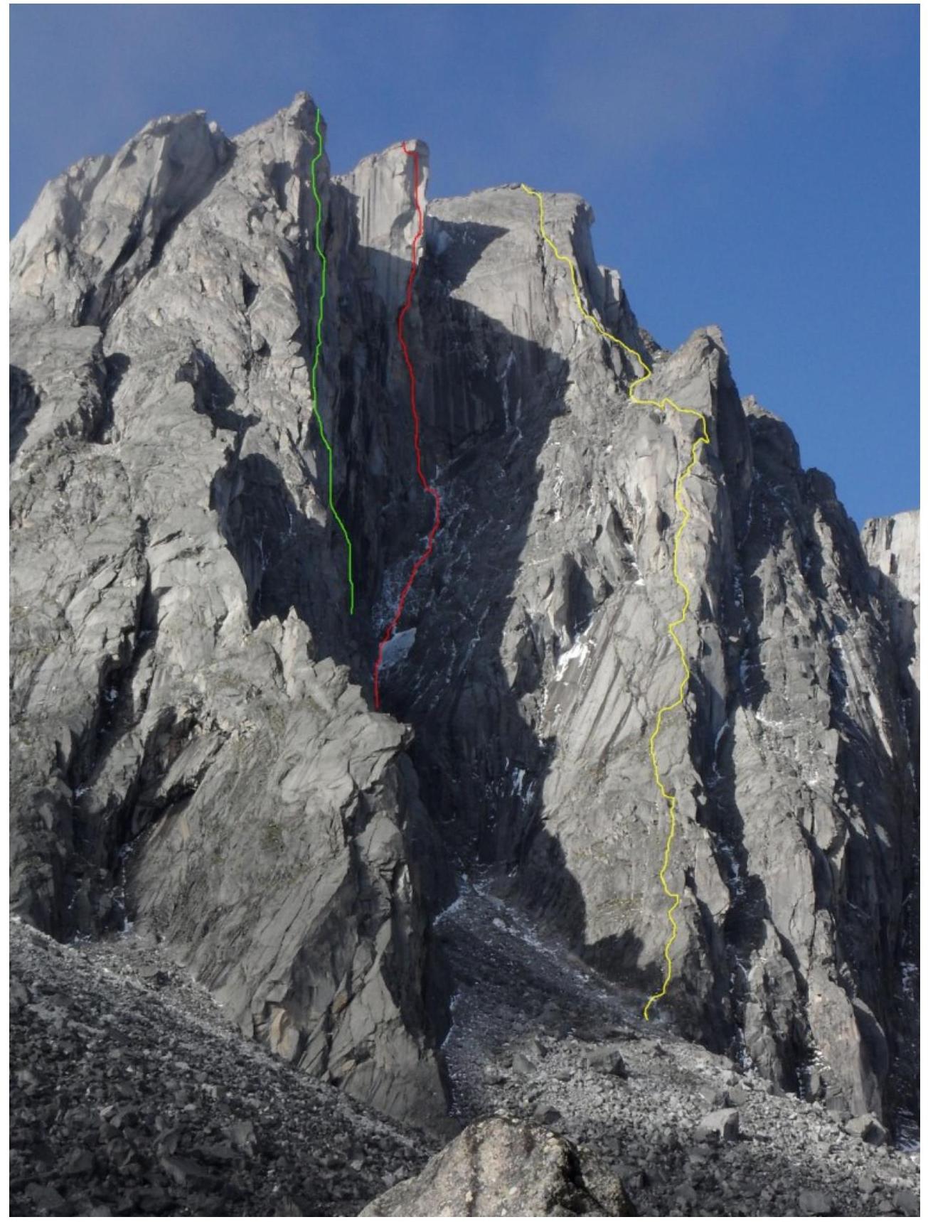
YELLOW — route climbed by the team
GREY — Afanasyev's 2002 route, 6A category.
YELLOW — Kuzmenko's 2010 route, 6A category.
Profile photo of the route on the left (panorama). The photo was taken during the first ascent of Kupol Peak via the Northeast plate on August 2, 2012, at an altitude of 2600 m.
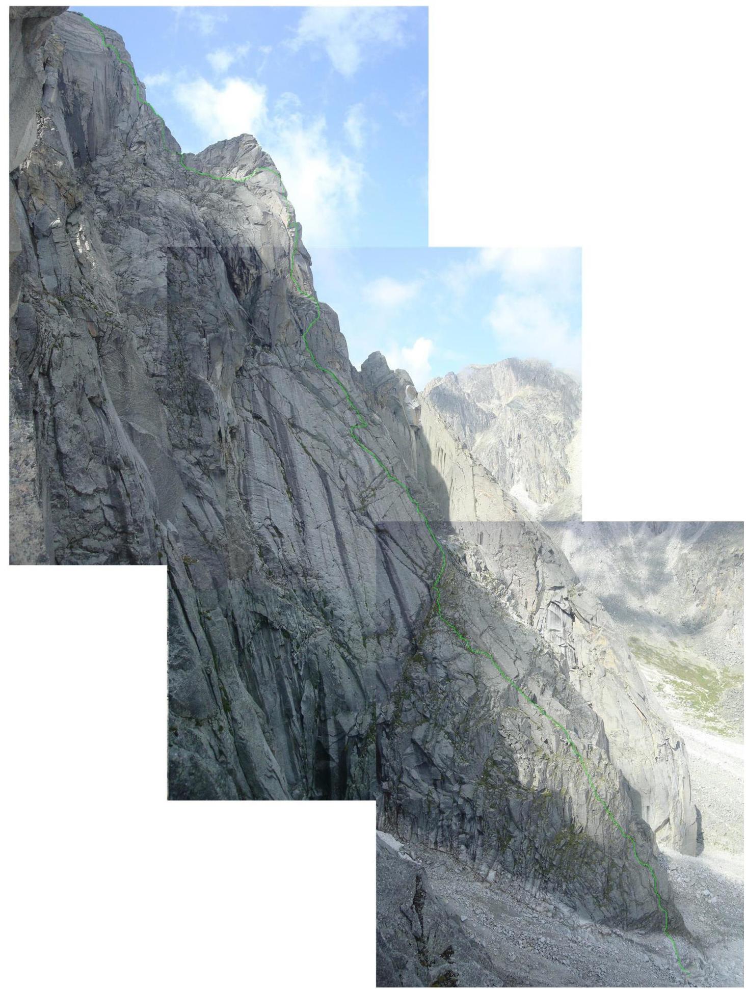
Profile photo of the route on the right (for clarity, the counterfort is highlighted). This photo can be used to objectively assess only the lower part of the route, as the middle and upper parts are turned towards the viewer, making it difficult to evaluate the steepness.
The photo was taken during the first ascent of 5A on the Charskie Zori peak, at an altitude of 2400 m.
Drawn profile of the
route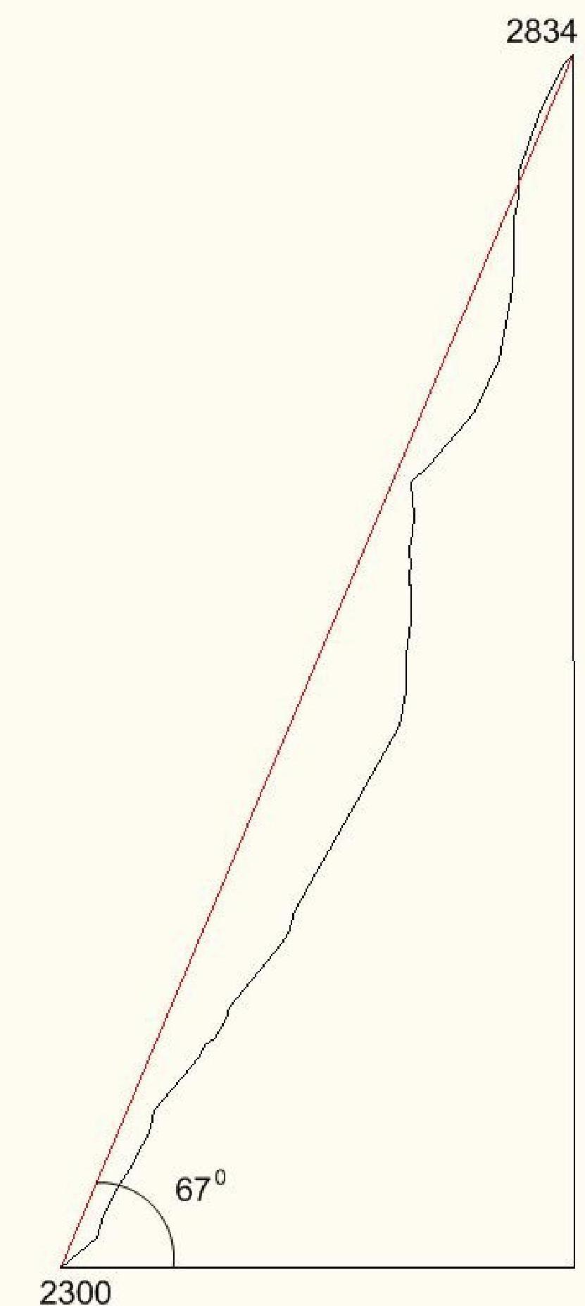
Panorama of the Alaska cirque
peaks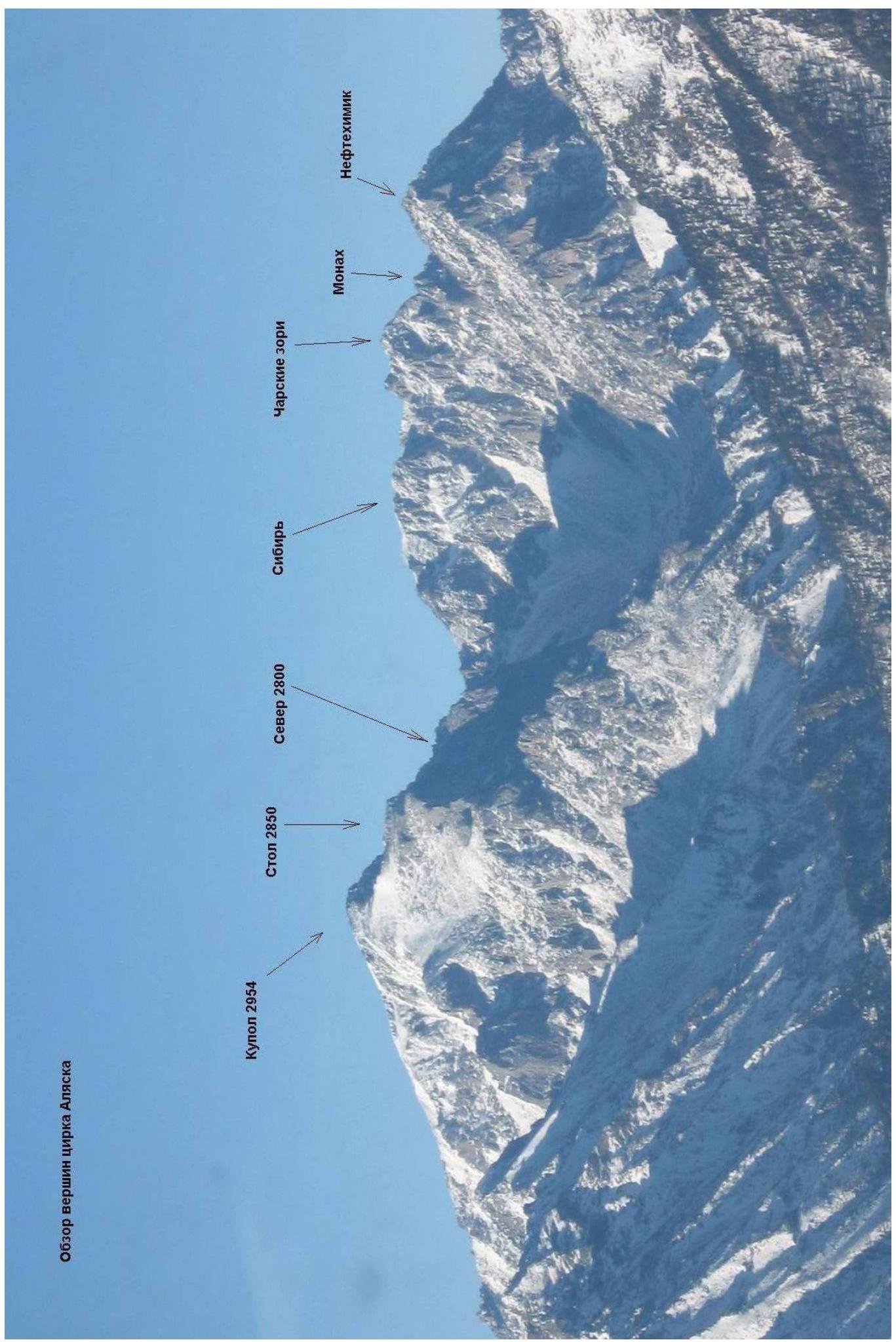
The Barun-Khandagai gorge is one of the most promising areas in the Eastern Sayan for sport climbing.
Kupol Peak (2954 m) is the dominant peak in the area. It is located in the Tunkinsky district of Buryatia. The nearest large settlement is the village of Arshan. From Arshan, a high-clearance vehicle can reach the entrance to the gorge, known as the Barunov "meadow," in about 15 kilometers. Further into the gorge, there is a trail, and the area is popular with tourists during the summer. The Alaska cirque is located to the left along the gorge, with an elevation gain of 1400 m and a length of approximately 15 km. In the summer, it takes 6–8 hours to reach the wall, while in winter, it may take 5–6 days due to the large amount of snow.
Several challenging routes pass through the North Face of Kupol Peak:
- 5B route by Afanasyev via the North Face in 1982
- 6A route by Afanasyev (Klinok) via the North Face, East shoulder in 2002, 1st place at the Russian Championships 2002
- 6A route by Afanasyev via the ledges of the North Face, East shoulder in 2007, 4th place at the Russian Championships 2007
- 6A route by Kuzmenko via the Central North Face, East plate in 2010
Ascent schedule
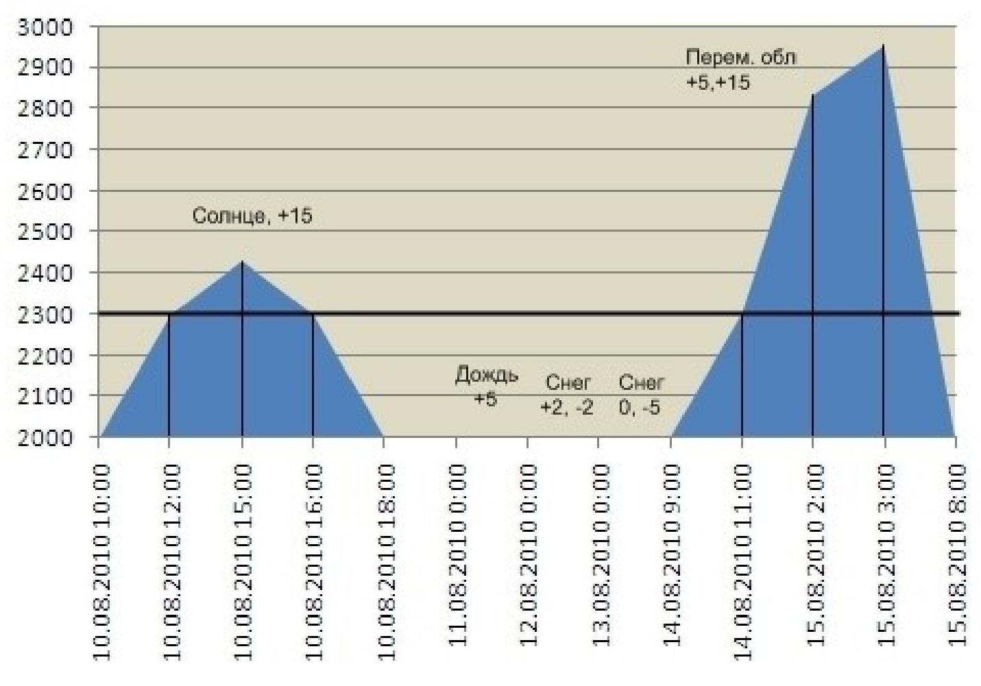
Team movement schedule on the route: August 10, 2010 — from 12:00 to 15:00, processing, sections R0–R13 completed
August 11–13, 2010 — Three days of unstable weather, rain and snow, waiting for a weather window.
August 14, 2010 — from 11:00 to 24:00, sections R13–R48 completed
August 15, 2010 — from 00:00 to 3:00, sections R48–R56 completed (reached the summit at 2954 m.)
August 15, 2010 — from 3:30 to 8:00, descent to Base Camp via route 1B (category V rock climbing).
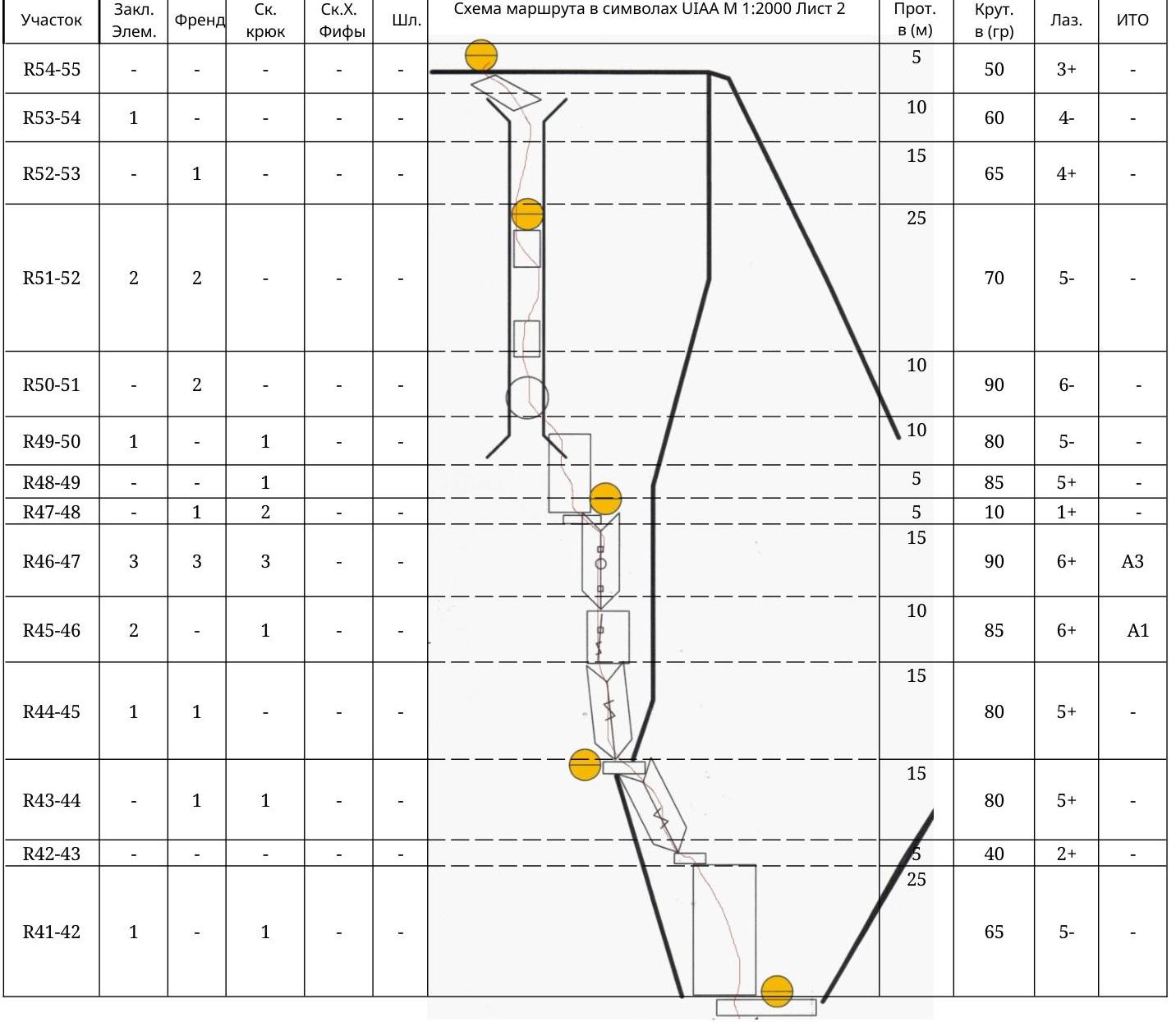
| Section | Chocks | Friends | Rock Pitons | Skyhooks Fifi | Bolts | UIAA M 1:2000 Symbol Sheet 1 | ||||||
|---|---|---|---|---|---|---|---|---|---|---|---|---|
| R43–R44 | - | 1 | 1 | 15 | 80 | 5+ | ||||||
| R41–R42 | 1 | - | 1 | 25 | 65 | 5- | ||||||
| R40–R41 | 1 | 1 | - | - | - | 20 | 50 | 4+ | ||||
| R39–R40 | - | - | 20 | 40 | 2+ | |||||||
| R38–R39 | 30 | 40 | 2+ | |||||||||
| R37–R38 | - | 2 | - | - | - | 5 | 70 | 5- | ||||
| R36–R37 | 15 | 65 | 5- | |||||||||
| R35–R36 | 1 | - | 2 | - | - | 10 | 40 | 3+ | ||||
| R34–R35 | - | - | 3 | 5 | - | 15 | 95 | 6+ | ||||
| R33–R34 | 1 | 2 | - | 10 | 85 | 5+ | ||||||
| R30–R31 | 3 | 2 | - | 5 | 75 | 5+ | ||||||
| R27–R30 | 4 | 3 | - | - | 14 | 85- | 6-(+) | |||||
| R26–R27 | 1 | 2 | - | 0.7 | 100 | 6+ | ||||||
| R25–R26 | 1 | 2 | - | - | 15 | 90 | 6- | |||||
| R24–R25 | 1 | 1 | - | - | 10 | 85 | 6- | |||||
| R23–R24 | - | 1 | 2 | - | - | 10 | 40 | 3- | ||||
| R22–R23 | 1 | 1 | - | - | 5 | 75 | 4+ | |||||
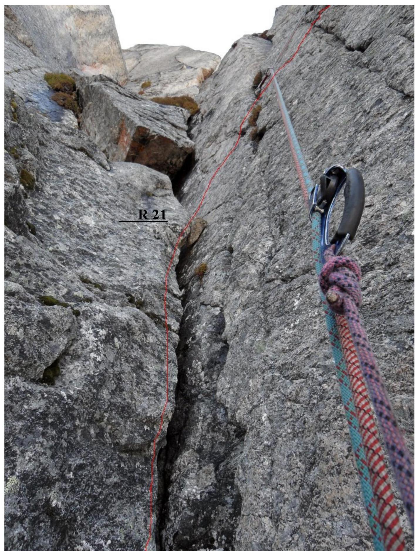
| R21–R22 | - | - | 1 | 10 | 90 | 6- | ||||||
| R20–R21 | 1 | - | 1 | - | 5 | 90 | 6- | |||||
| R19–R20 | 1 | 1 | - | - | 15 | 80 | 5- | |||||
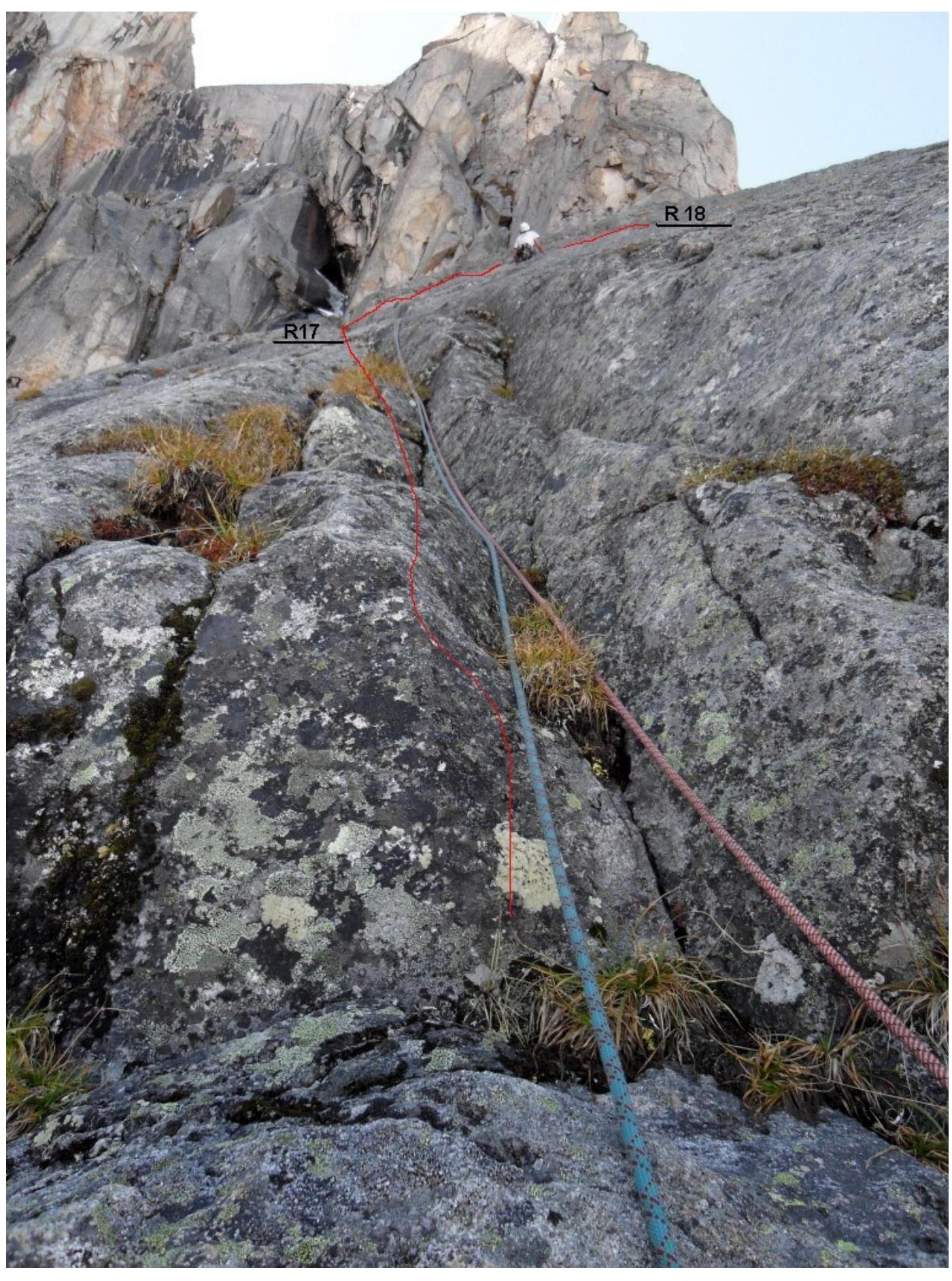
| R18–R19 | 1 | 1 | 2 | - | - | 25 | 60 | 5- | ||||
| R17–R18 | - | 1 | - | - | 10 | 60 | 4+ | |||||
| R16–R17 | 1 | - | 1 | 20 | 60 | 5- | ||||||
| R15–R16 | 35 | 60 | 5- | |||||||||
| R14–R15 | - | 1 | 3 | - | - | 10 | 75 | 5- | ||||
| R13–R14 | 5 | 55 | 3- | |||||||||
| R12–R13 | 2 | 2 | 2 | - | - | 35 | 50 | 3- | - | |||
| :--: | :--: | :--: | :--: | :--: | :--: | :--: | :--: | :--: | :--: | :--: | ||
| R11–R12 | 5 | 80 | 5- | - | ||||||||
| R10–R11 | 10 | 60 | 4+ | - | ||||||||
| R9–R10 | 2 | 2 | - | - | - | 5 | 30 | 2- | - | |||
| R8–R9 | 5 | 70 | 5- | - | ||||||||
| R7–R8 | 30 | 50 | 3- | - | ||||||||
| R6–R7 | 10 | 75 | 5- | - | ||||||||
| R5–R6 | 1 | 1 | 1 | - | - | 10 | 60 | 4- | - | |||
| R4–R5 | 5 | 65 | 5- | - | ||||||||
| R3–R4 | 1 | 1 | 1 | - | - | 10 | 60 | 5- | - | |||
| R2–R3 | 1 | 1 | 15 | 60 | 4+ | - | ||||||
| R1–R2 | 1 | - | - | 10 | 75 | 5- | - | |||||
| R0–R1 | - | - | - | - | - | 20 | 40 | 2- | - |
- Diagram of the main section of the route in UIAA symbols, scale 1:2000, sheet 1
- Diagram of the main section of the route in UIAA symbols, scale 1:2000, sheet 2
Terrain Description
R0–R1 400, 20 m, 2B — Ram's foreheads, exit under the wall of the counterfort. R1–R2 750, 10 m, 5B — Wall, exit to a flattening, to a system of cracks. R2–R3 600, 15 m, 4+ — Along the plate with a system of cracks upwards to the left, loose rocks. R3–R4 600, 10 m, 5B — Plate with a crack upwards. R4–R5 650, 5 m, 5B — Wall. R5–R6 600, 10 m, 4B — Exit to a comfortable ledge, good belay station. R6–R7 750, 10 m, 5B — From the station to the left, complex climbing. R7–R8 500, 30 m, 3B — Easy climbing on the left side of the rib. R8–R9 700, 5 m, 5B — Wall, exit to a niche under an internal corner (IC). R9–R10 300, 5 m, 2B — Along the niche, under IC, comfortable belay station. R10–R11 600, 10 m, 4+ — To the left of the station, rib under the wall. R11–R12 800, 5 m, 5B — Wall with a crack, exit to a flattening. R12–R13 500, 35 m, 3B — Easy climbing on the left side of the rib, belay station. R13–R14 550, 5 m, 3B — From the station to the right, destroyed rocks. R14–R15 750, 10 m, 5B — Wall on the rib of the counterfort. R15–R16 600, 35 m, 5B — Along the monolithic rib, few places for belay organization. R16–R17 600, 20 m, 5B — Along the plate and crack to the left upwards. R17–R18 600, 10 m, 4+ — Traverse to the right along the crack. R18–R19 600, 25 m, 5B — Crack with grass, belay station on a comfortable ledge. R19–R20 800, 15 m, 5B — Internal corner. R20–R21 900, 5 m, 6B — Wall in the internal corner. R21–R22 900, 10 m, 6B — Wall to the right of the internal corner. R22–R23 750, 5 m, 4+ — Exit to a short ridge. R23–R24 400, 10 m, 3B — Along the ridge, comfortable belay station near the wall. R24–R25 850, 10 m, 6B — Wall with destroyed terrain, start of the first crux. R25–R26 900, 15 m, 6B — Crack to the right of the split. R26–R27 1300, 0.7 m, 6+ — Overhang. R27–R28 900, 3 m, 6+, A2 — Crack after the overhang, monolithic terrain. R28–R29 850, 6 m, 6-, A2 — Crack to the right under the overhang. R29–R30 1000, 5 m, 6+, A3 — Overhang, uncomfortable expanding outward crack. R30–R31 750, 5 m, 5+, A1 — IC, left wall slightly overhanging. R31–R32 800, 3 m, 4- — Descent to a shelf. R32–R33 250, 10 m, 3+ — To the right along the shelf. R33–R34 850, 10 m, 5+ — To the left upwards along the crack. R34–R35 950, 15 m, 6+, A3 — Upwards along the system of intermittent cracks, complex ITO. R35–R36 400, 10 m, 3+ — Inclined ledge, belay station at the end. R36–R37 650, 15 m, 5- — Coil from the ledge to the left upwards, towards a wide ledge.
R37–R38 70°, 5 m, 5 — Descent to a ledge.
R38–R39 40°, 30 m, 2+ Wide ledge.
R39–R40 40°, 20 m, 2+ IC — couloir.
R40–R41 50°, 20 m, 4+ Destroyed IC.
R41–R42 65°, 25 m, 5 — Wall.
R42–R43 40°, 5 m, 2+ Ledge.
R43–R44 80°, 15 m, 5+ IC, transition to the left side of the rib. Belay station on a ledge.
R44–R45 80°, 15 m, 5+ IC from the ledge towards a vertical IC above.
R45–R46 85°, 10 m, 6+, A1 Wall with a small crack under IC.
R46–R47 90°, 15 m, 6+, A3 IC with a block in the middle, narrow crack in IC.
R47–R48 10°, 5 m, 1 — Ledge, belay station.
R48–R49 85°, 5 m, 5+ Wall from the ledge on the left side.
R49–R50 80°, 10 m, 5 — Exit to a wide chimney.
R50–R51 90°, 10 m, 6 — Wide chimney with a plug.
R51–R52 70°, 25 m, 5+ — along the wide chimney.
R52–R53 65°, 15 m, 4+ — along the chimney.
R53–R54 60°, 10 m, 4- — along the chimney.
R54–R55 50°, 5 m, 3+ — exit to a beach.
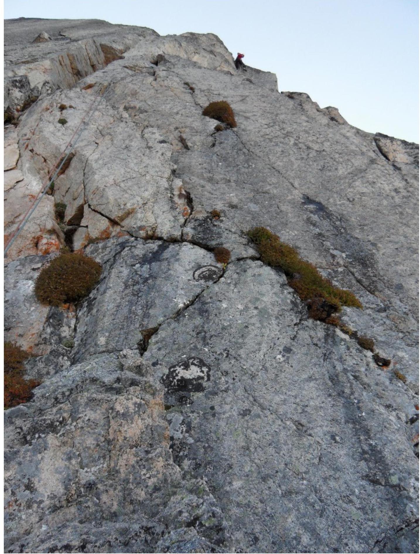
R55–R56 25°, 370 m, 1- — exit to the summit. Technical photo of the
route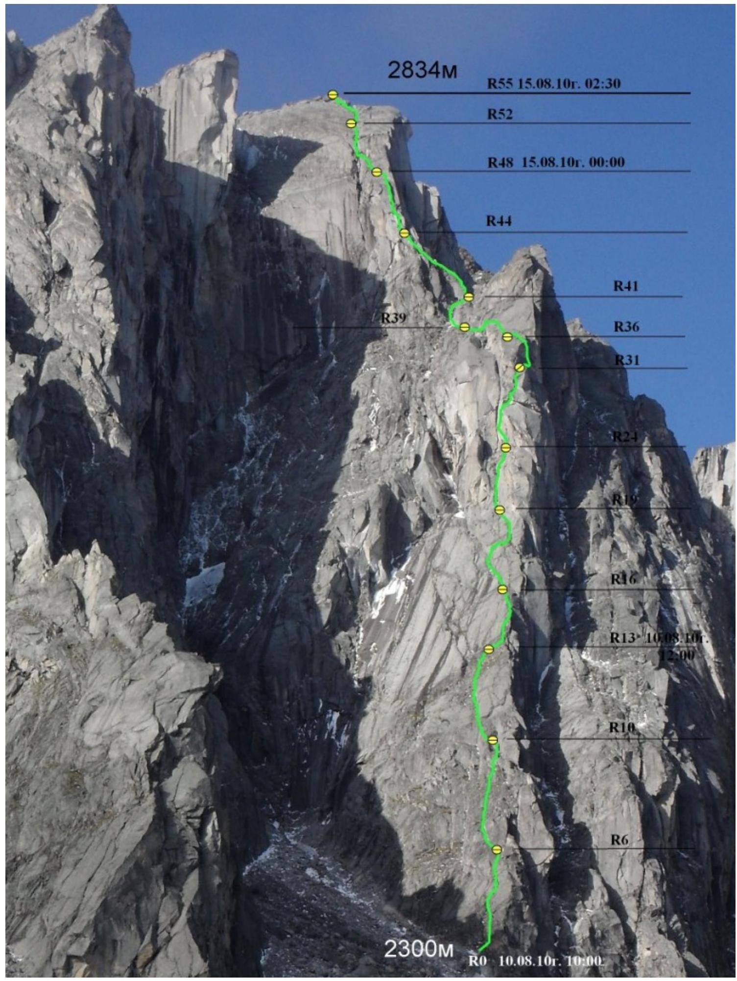
Route Characteristics and Team Actions on the Wall
The route taken by our team passes through the central counterfort of the North Face and is the most logical line on the North Face of Kupol Peak. To the left of the route, there are three lines of category 6A, and to the right, behind the counterfort, there is a category 5B route. The route is protected from rockfall as it largely follows the rib of the counterfort, except for two vertical key sections totaling about six rope lengths.
After studying the intended route, we decided to climb without a bivouac, processing three rope lengths on the first day. The next three days were marked by rain and snow, and the team waited in Base Camp for a weather window.
On the 14th, the weather was clear in the morning, but we delayed our start until 11:00 due to the formation of ice on the wall after the prolonged bad weather. By 11:00, the ice and snow had melted from the counterfort, but ice continued to fall from the rest of the wall until late at night. We reached the summit only at 3:00 AM on August 15, 2010, due to the late start.
The terrain on the route is generally reliable and monolithic, with rocks dislodged during the ascent falling away from the team's trajectory. Due to the low rockfall risk, the route can be used for methodological purposes and is recommended for participants as a first category 5B route.
The route length exceeds six hundred meters, and with sufficient preparation, it can be completed in a daylight period, like most Sayan "fives." When climbing in winter, there is a large ledge — "balcony" — near the top third of the route, suitable for organizing a bivouac, where a standard tent can be set up in a rockfall-protected area.
Currently, this route is the longest technically challenging route in the Barun-Khandagai gorge and the Tunkinskiye Goltsy ridge (14 rope lengths).
Due to a camera malfunction (it was broken), the last photo on the route was taken on section R34–R35.
- Photo taken at the start of the route on August 14, 2010, around
10:00

- Fourth relatively easy rope length, first climber at point
R16.

- Fifth rope length, exit under the first key
section.
- Sixth rope length — start of the key section. Traverse to the
right.
- Seventh rope length, main wall of the first
bastion.
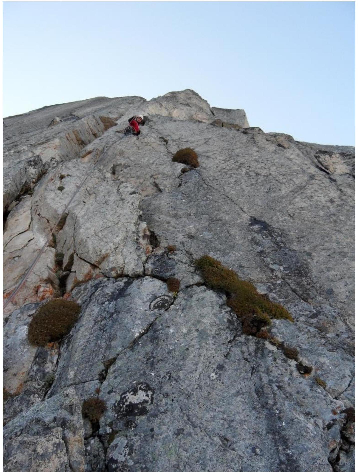
Photo taken from point R24, first climber on section R25–R26. Seventh rope length:
- First climber passing the overhang on section R29–R30.
Eighth rope length, section R34–R35:
- Complex ITO through deaf cracks;
- Visible exit from the first bastion.
After this, the camera was broken while working on the belay, and there are no further photos from the upper part of the route and the summit.
