Petrel 2929 m, 2B, October 31, 1978. V. Monomarchuk + 5 people (height difference 630 m, steepness 40°, snow depth 5 cm, 6 h).
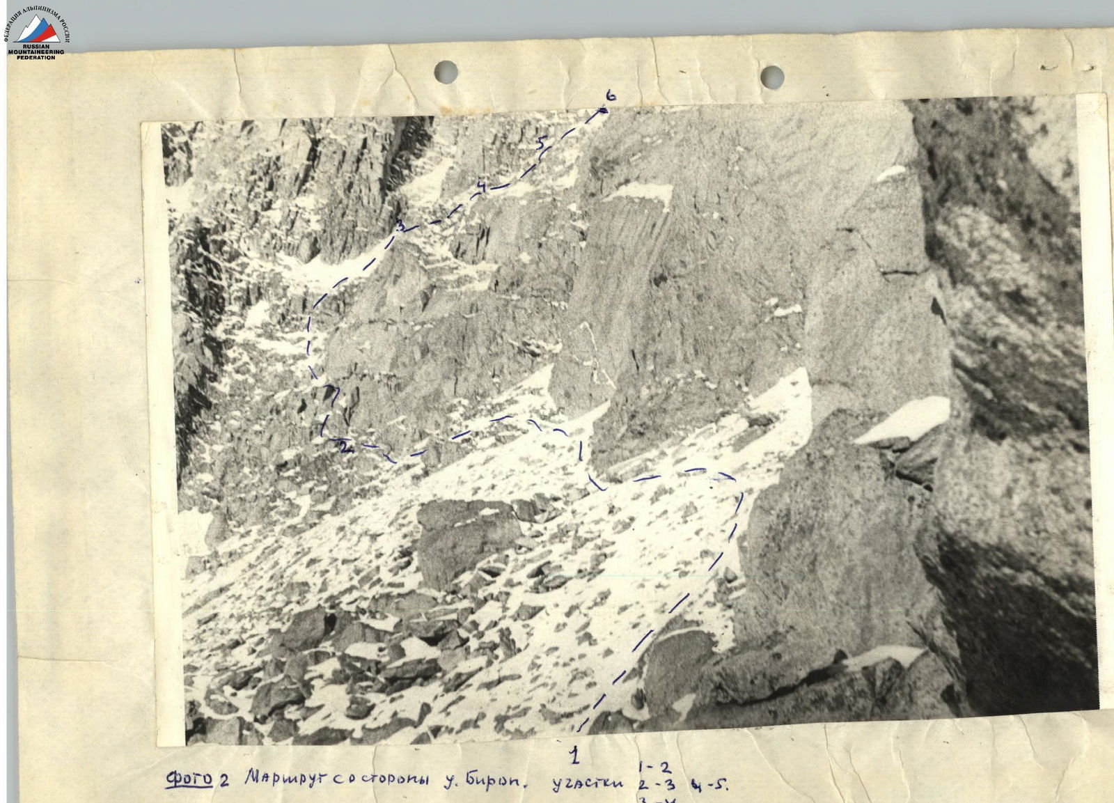
Photo 2. The route from the Birop gorge side. Sections:
- R2–R3
- R4–R5
- R3–R4
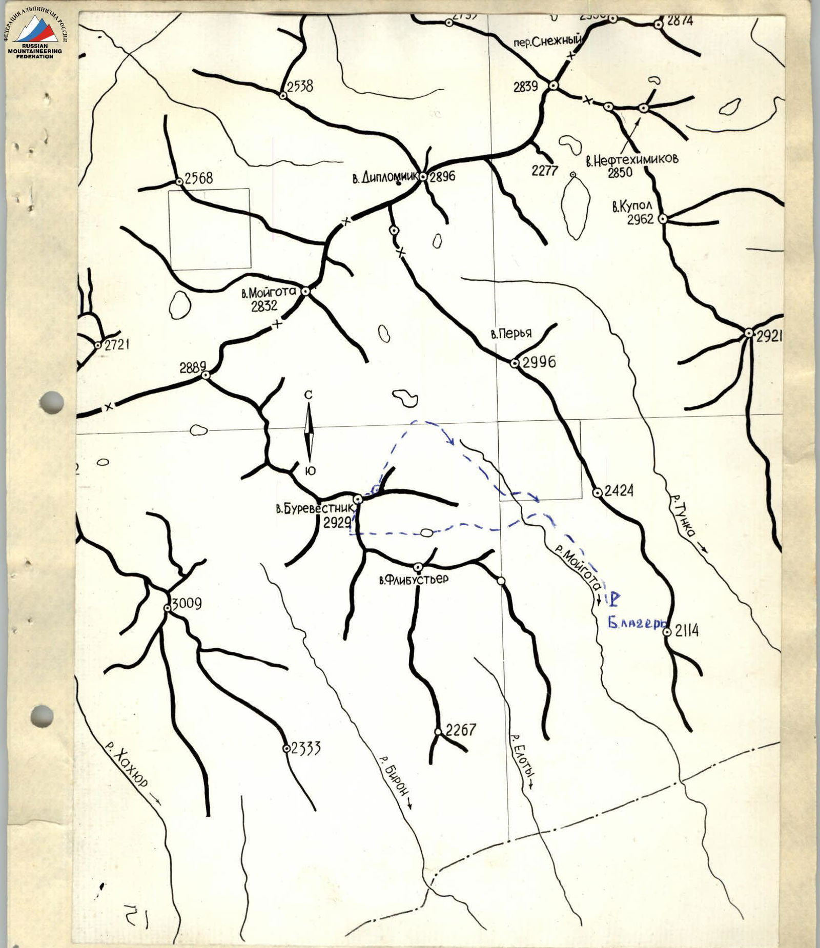
Map of the ascent area. The route is assault (2 groups). Б. лагерь — base camp.
Brief administrative and geographical outline of the ascent area
Peak 2929 m («Petrel») is located in the eastern part of the Tunkinskie Goltsy ridge of the Eastern Sayan, in the valley of the Moygota River. Vegetation is typically taiga:
- cedar
- pine
- larch
The forest boundary is at an altitude of 1750 m. The fauna is rich and diverse. The climate of the region is sharply continental. In the valley (Tunkinskaya), the average temperature of winter months reaches −30 °C. In the mountains it is 5–10 °C warmer.
In summer, spring and autumn in the mountains (Tunkinskie Goltsy) cloud cover is increased compared to the valley.
Precipitation in the mountains:
- Summer — 500 mm
- Winter — 600–1000 mm
The greatest height of snow cover is observed in March — April. There is no glaciation in the area of ascents.
Administratively, the ascent area belongs to the Buryat ASSR. Climbing development of the area began in November 1970. Currently, 6 routes from 1B to 3B category of complexity have been classified in the area.
Brief description of the Moygota River gorge and approach to the ascent route
The Moygota River valley is located 25 km from the Arshan resort. A good landmark is the rocky pyramid of Flibustier peak. The gorge is steep, difficult to pass. In the middle part, the gorge is pinched by a canyon. There is no trail. Approaches to the forest boundary (1750 m) take 8–10 hours.
From the forest boundary begins the ascent along the moraine, from which the further path is clearly visible. After 500 m to the left along the path, the path turns onto a steep large-boulder scree, having overcome which, you find yourself in a hanging cirque of Flibustier and Petrel peaks. Having passed 500 m along the bottom of the cirque, you approach a round glacial lake, from which the exit to the ridge is clearly visible (photo #1).
TABLE OF MAIN CHARACTERISTICS OF THE ASCENT ROUTE
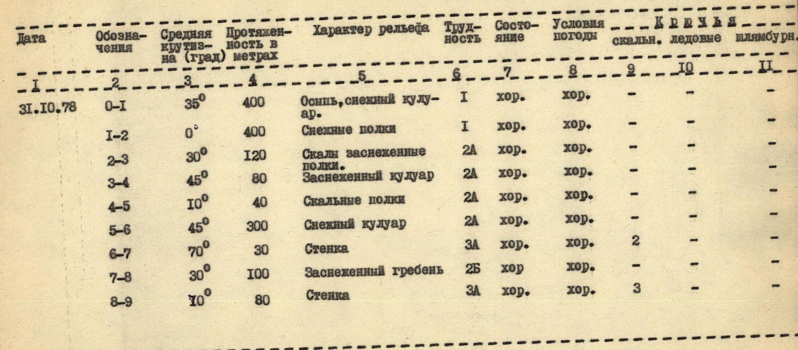
| Date | Designations | Average steepness (deg) | Length (m) | Relief character | Difficulty | Condition | Weather conditions | Rock | Ice | Bolted |
|---|---|---|---|---|---|---|---|---|---|---|
| October 31, 1978 | R0–R1 | 35° | 400 | Scree, snow couloir | 1 | good | good | – | – | – |
| R1–R2 | 0° | 400 | Snow shelves | 1 | good | good | – | – | – | |
| R2–R3 | 30° | 120 | Snow-covered rocky shelves | 2А | good | good | – | – | – | |
| R3–R4 | 45° | 80 | Snow-covered couloir | 2А | good | good | – | – | – | |
| R4–R5 | 10° | 40 | Rocky shelves | 2А | good | good | – | – | – | |
| R5–R6 | 45° | 300 | Snow couloir | 2А | good | good | – | – | – | |
| R6–R7 | 70° | 30 | Wall | 3А | good | good | 2 | – | – | |
| R7–R8 | 30° | 100 | Snow-covered ridge | 2Б | good | good | – | – | – | |
| R8–R9 | 10° | 80 | Wall | 3А | good | good | 3 | – | – |
Brief explanation for the table
From the lake in the cirque of «Flibustier» and «Petrel» peaks along the large scree, then along the couloir filled with snow, towards the pass (to the left of the sharp gendarme on the ridge — gendarme I); gendarme I is bypassed on the left along the path along wide snow shelves, then along scree, snow and rocky shelves bypassing gendarmes II, III, 520 m (see diagram); entrance to the I couloir and along it 80 m, traverse to the right 40 m, to the II couloir (see diagram) with snow and slabs, along it up — 300 m, bypassing gendarme IV, exit to the ridge. When exiting to the ridge, there is a 30 m wall, 70°, piton belay. Then along the ridge 20 m and 40 m bypassing gendarme V (see diagram), 40 m along the ridge, approach to the summit tower (key to the route) — piton belay — 80 m. Summit.
Descent to the northeast along a snow-covered slope with rocky outcrops, towards the saddle between «Petrel» and East Petrel. Further to the left along the scree couloir.