Pik Baruun from the south Suvorkina L.D. Sayan Vostochny, 6B
Ascent Passport
- Ascent class: technical
- Area: Eastern Sayan, Tunkin Goltsy, Baruun-Khandagai gorge
- Peak: 2874 m Pik Baruun from the south
- Proposed: 2A cat. diff.
- Route type: combined
- Route characteristics:
Elevation gain: 800 m. Route length: 1412 m. Length of section with 3rd cat. diff.: 22 m. Length of section with 2nd cat. diff.: 200 m. Length of section with 1st cat. diff.: 1190 m. Steepness of the main part of the route 40°
-
Used on the route:
Number of fixed protection: 15
-
Duration: 9 hours
-
Leader: Suvorkina Lyudmila Davydovna, Candidate for Master of Sports
-
Participants: Zakharov Alexander Viktorovich, badge
Zholudeva Nina Sergeevna, badge Ipatyeva Ekaterina Grigoryevna, badge Kuptsov Pavel Nikolaevich, badge Trzhbyatovsky Nikolai Grigoryevich, 1st sports category
-
Coach: Suvorkina Lyudmila Davydovna
-
Date of departure: October 28, 2008
Summit: October 28, 2008 Return: October 28, 2008
-
Organization: Krasnoyarsk City Federation of Alpinism
Photo 1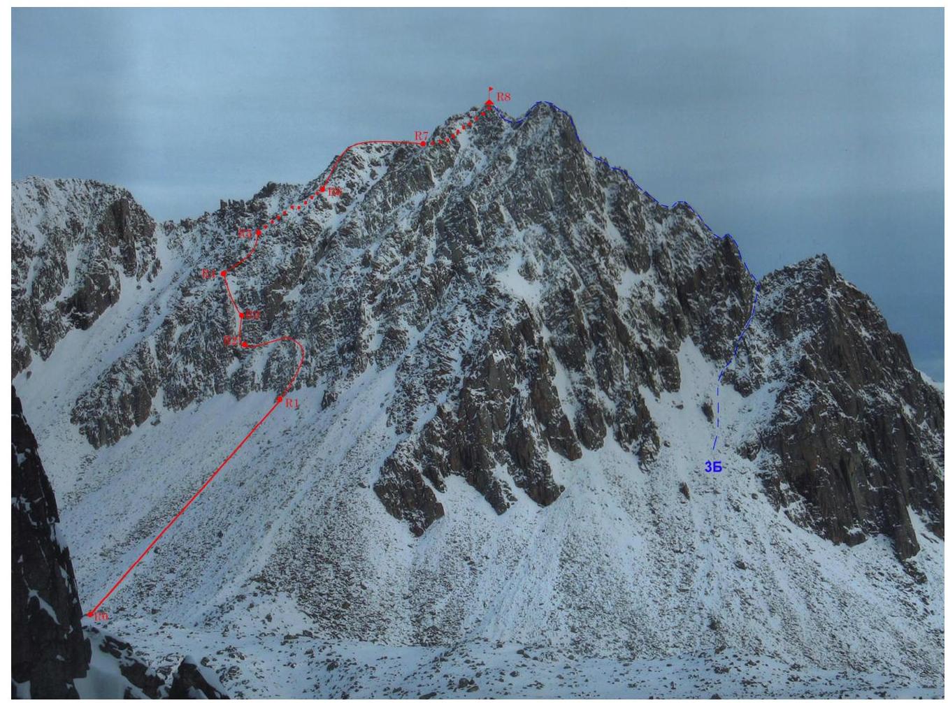
Pik Baruun 2874 m. Shot from Pik Monakh
Route Description
Pik Baruun is located in the upper reaches of the Baruun-Khandagai gorge. It is a wide trough valley with dense forest. The trail is bad, often blocked by moraine ridges. The base camp is located in the forest zone at an altitude of 1800 m. There are two small cabins.
The 2A route to Pik Baruun is located in the cirque:
- Neftyanikov
- Monakh
- Charskie
- Zori
- Dobraya
- Blagoveshchensk
- Baruun
From the base camp, we go along the trail up the gorge, bypassing Pik Neftyanikov to the right, passing by a cabin, a lake, and rising to a terrace closer to Pik Baruun. We start the route from the middle of the lake, located on the southern side of the peak.
R0–R1 — scree 500 m, 25–30°, I cat. diff. simultaneous.
R1–R2 — ascent on rocks 40 m, 40°, traverse left to the couloir 90 m. II cat. diff. rope protection, 8 fixed protection.
R2–R3 — descent into the couloir 3 m, wall 4 m, 80°, passage along the right wall of the couloir 15 m. III cat. diff. rope protection. Belay station. Control cairn. 5 fixed protection.
R3–R4 — crossing the couloir to the left and movement along the left wall to the ridge 50 m, 35–40°, II cat. diff. 2 fixed protection. Belay station on the ridge behind the terrain feature. In the narrow place of the couloir, there is ice.
R4–R5 — movement along the ridge simultaneous and alternating 100 m, 35–45°, I–II cat. diff. (80+20) to the vertical wall.
R5–R6 — descent from the ridge to the left 10 m, II cat. diff., rope protection. Traverse on snow 80 m to the ridge 30–40° simultaneous, I cat. diff.
R6–R7 — movement along the ridge simultaneous and alternating I–II cat. diff., 30–45°, 150 m (140+10). The ridge turns right towards the summit on large rocks 200 m, I cat. diff.
R7–R8 — ridge 200 m, small ledges, walls, large rocks 30–40°, I–II cat. diff. (190+10). Simultaneous movement.
Descent to the north via 1B.
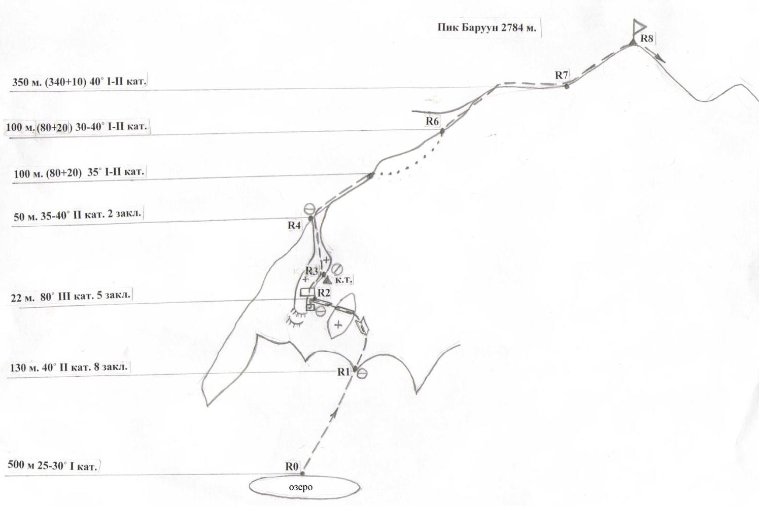
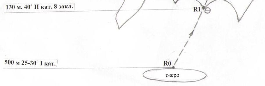
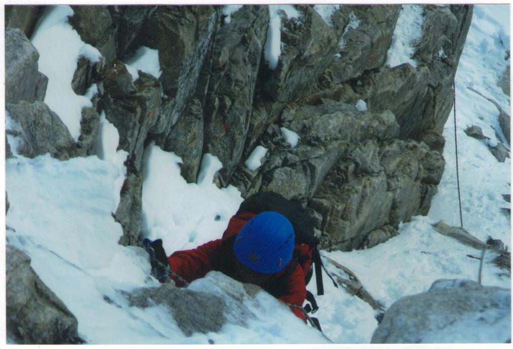
Photo 2 on section R2–R3
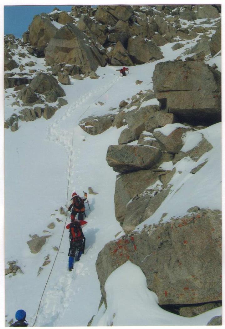
Photo 3 on section R5–R6
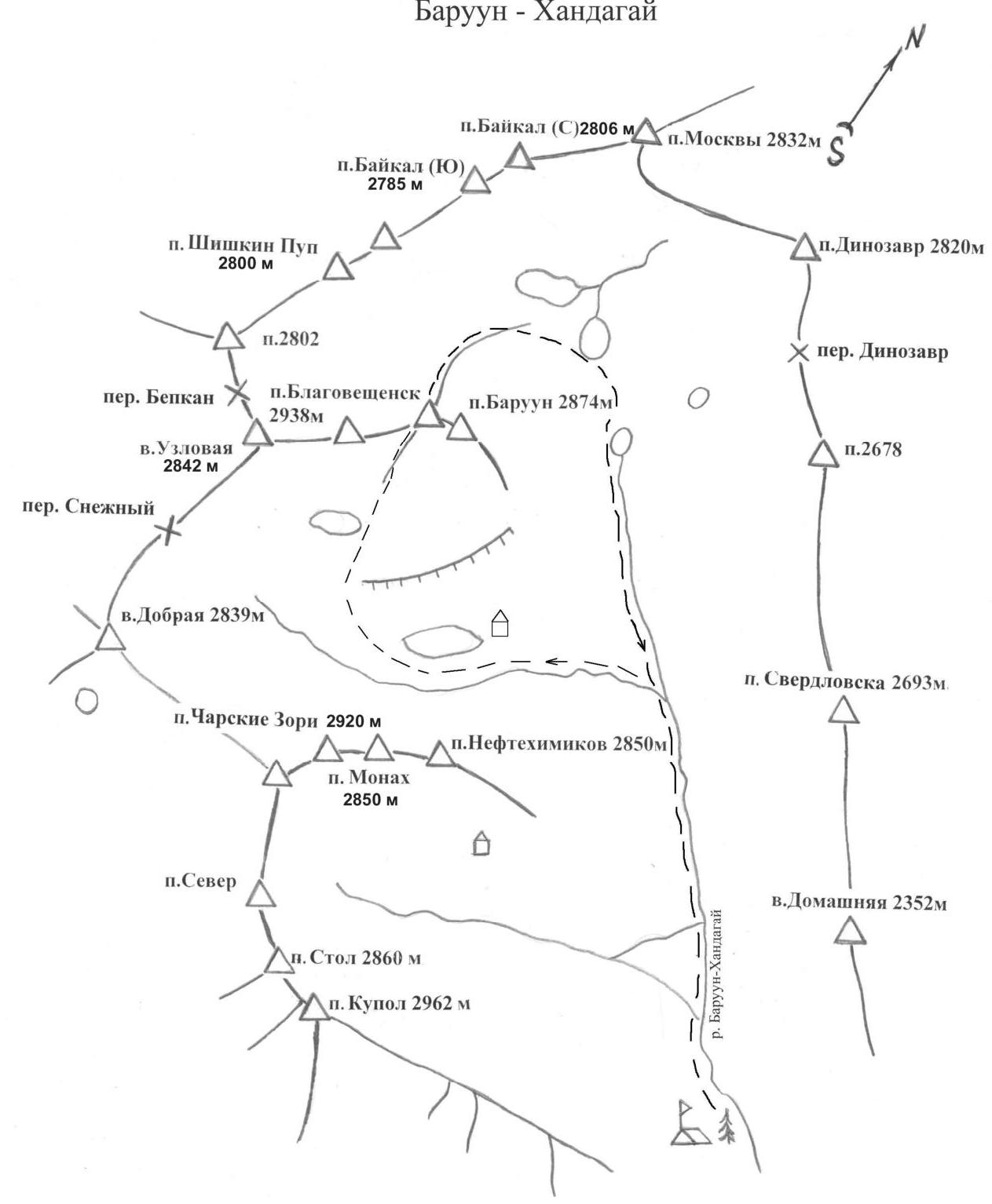
Baruun-Khandagai
To the southwest of Lake Baikal, in the southeast of the vast mountain system of Eastern Sayan, is the large ridge of Tunkin Goltsy. To the south, it is adjacent to the steppes of the Tunka valley, and to the north, the picturesque valley of the Kitoy River, behind which stand the Kitoy Goltsy. Further north lies the Central Sayan plateau, the chains of the Big Sayan, and the northeast of Tuva.
Winters in Tunka are cold and windless. There are many sunny days. Frosts reach -38–40° maximum, with an average temperature of -17–25°. As a rule, there is little snow. Spring is inclement, with frequent small snowfalls. The temperature in April is already above zero. Avalanche danger arises in late March and persists until mid-May. However, there are cases in October-November as well. Summer is not hot, rainy, especially in the second half of July and August, with thunderstorms and downpours. Autumn is clear and warm. On the southern slope of the Tunka Goltsy is the Arshan resort.
In the early 60s, climbers from Irkutsk, Bratsk, and Ulan-Ude began a massive assault on the peaks of Tunka. The most accessible gorges are being explored:
- Kyngarga
- Moigoty
- Zuun-Khandagai
- Baruun-Khandagai
The Baruun-Khandagai gorge is located between the Bilyuty and Zuun-Khandagai gorges, 12 km from the Arshan resort. To the west from Arshan, through the village of Tagarkhay (7 km) to the "Lesnichikha" clearing (5 km), go into the left gorge. The trail initially follows the left orographic bank, then after crossing a log, it goes along the right bank in dense forest, often far from the water.
The approach with a load takes 5–7 hours. The base camp is at the forest boundary. The most well-known peaks:
- Baruun — 2874
- Neftyanikov — 2850
- Kupol — 2962
- Stol — 2940
The peak Baruun via routes 1B and 2A cat. diff., Monakh via 2B cat. diff., Charskie Zori via 3A cat. diff. have long been climbed by local climbers and Krasnoyarsk residents, but are not included in the classifier.
660049, Krasnoyarsk, Karla Marksa ave., 49 Suvorkina Lyudmila Davydovna obednin@list.ru kmcp@inbox.ru