Peak Baruun From the North Suvorkina L.D. East Sayan, 6.1
Ascent Passport
- Ascent category: technical
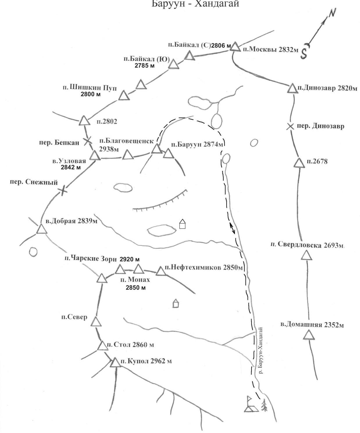
- Region: East Sayan, Tunkinskie Goltsy, Baruun-Khandagai gorge.
- Summit: 2874 m. Peak Baruun from the North.
- Proposed category: 1B category.
- Route type: rock.
- Route description:
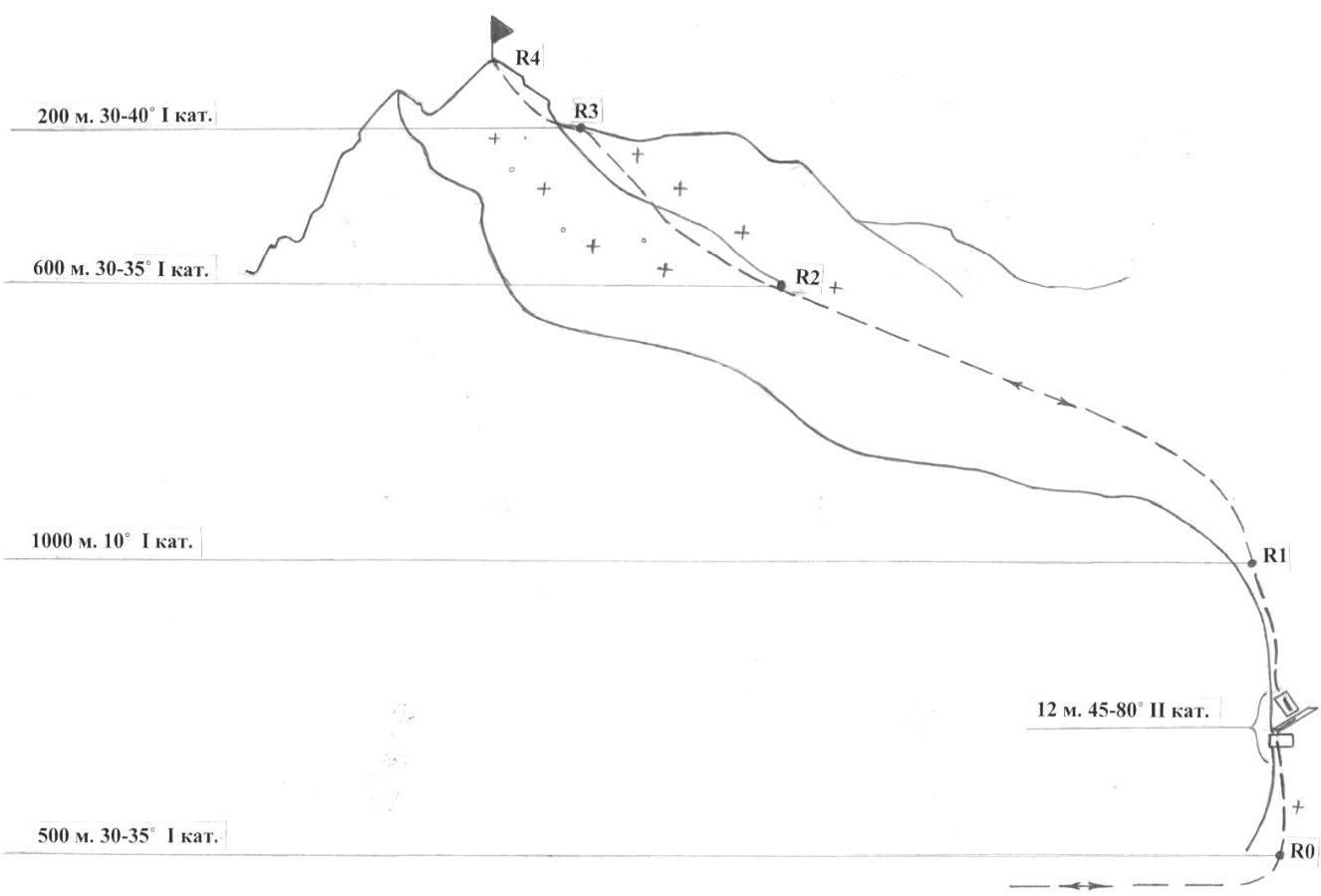
Height difference: 800 m. Route length: 2312 m. Route length of 2nd category: 32 m. Route length of 1st category: 2280 m.
- Equipment used on the route:
- Duration: 12 hours
- Leader:
Suvorkina Lyudmila Davydovna CMS Members:
- Zholudeva Nina Sergeevna badge holder
- Zakharov Alexander Viktorovich badge holder
- Kuptsov Pavel Nikolaevich badge holder
- Trzbyatovsky Nikolai Grigorievich 1st sports category.
- Coach: Suvorkina Lyudmila Davydovna
- Dates:
departure 20 October 2008
summit 20 October 2008
return to camp 20 October 2008
- Organisation: Krasnoyarsk City Federation of Alpinism.

Route Description
From the camps in the forest zone, we follow the trail up the gorge. We pass peaks Neftekhimikov and Baruun to the upper lake under peak Baikal (3–4 hours) and start ascending left up the ridge.
R0–R1 — ridge 30–35° 500 m. 1st category, simultaneously, in the middle wall 2.5 m, 80°, narrow horizontal ledge 4 m and wall 6 m 45° — 2nd category. Fixed ropes. R1–R2 — snowy plateau with gradual ascent 1000 m. 10–15° 1st category. R2–R3 — rocky, broken counterfort 600 m. 30–35°, exit via snow to the right shoulder 1st category. R3–R4 — ridge 200 m. 35–40°. Ledges, small walls (190 + 10) m. 1–2 category. Ascent to the summit. Descent via the ascent route.
Time taken for the ascent from camp to camp was 12 hours.
Peak Baruun 2874 m.
Peak Baruun 2784 m.
 Photo 2 On section R1–R4
 To the southwest of Baikal, to the southeast of the vast mountain system
East Sayan lies the large Tunkinskie Goltsy ridge.
To the south, it is adjacent to the steppes of the Tunkinskaya valley, and to the north —
the picturesque Kitoy river valley, beyond which stand the Kitoy Goltsy.
Even further north lies the Central Sayan Plateau, the chains
of the Big Sayan and the northeast of Tuva.
To the southwest of Baikal, to the southeast of the vast mountain system
East Sayan lies the large Tunkinskie Goltsy ridge.
To the south, it is adjacent to the steppes of the Tunkinskaya valley, and to the north —
the picturesque Kitoy river valley, beyond which stand the Kitoy Goltsy.
Even further north lies the Central Sayan Plateau, the chains
of the Big Sayan and the northeast of Tuva.
Winters in Tunkinsk are cold and windless. Many sunny days. Frosts reach −38–40 ° maximum, average temperature is −17–25 °. Typically, there is little snow. Spring is inclement, with frequent small snowfalls. Temperature in April is already above zero. Avalanche danger arises in late March and persists until mid-May. However, there are cases in October–November as well. Summer is not hot, rainy, especially in the second half of July and August — thunderstorms with downpours. Autumn is clear and warm. On the southern slope of the Tunkinskie Goltsy lies the Arshan resort.
In the early 60s, climbers from Irkutsk, Bratsk, Ulan-Ude began a mass assault on the peaks of Tunkinsk. The most accessible gorges are being explored: Kyngarga, Moigoty, Zuun-Khandagai, Baruun-Khandagai. Baruun-Khandagai gorge is located between the Bilyuta and Zuun-Khandagai gorges, 12 km from the Arshan resort. West of Arshan, through Tagarhay village (7 km) to the "Lesnichikha" clearing (5 km) — head into the left gorge. The trail initially follows the left bank, then after crossing a log, it follows the right bank in dense forest and often far from water. Approach with a load takes 5–7 hours. Base camp — at the forest boundary. Most notable peaks: Baruun 2874 m, Neftekhimikov 2850 m, Kupol 2962 m, Stol 2940 m. Peak Baruun via routes 1B and 2A category, Monakh via 2B category, Charskie Zori via 3A category have been climbed many times by local climbers and Krasnoyarsk residents, but are not listed in the classifier.
660049, Krasnoyarsk, Karla Marksa ave., 49 Suvorkina Lyudmila Davydovna obednin@list.ru kmcp@inbox.ru