Ascent Passport
- Ascent class - technical.
- Ascent area - South-Western Pamir, Shugnan Range.
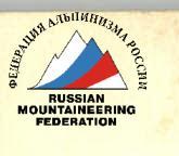
- Peak, its height, ascent route: Peak 4900 m, via the SE counterfort.
- Proposed difficulty category - 5A.
- Route characteristics: height difference - 1050 m, length of sections with 5-6 cat. diff. - 555 m, average steepness - 69°.
- Pitons driven: for belaying: for creating ITO:
- rock - 72 (for belaying), 4 (for creating ITO)
- ice (including into rocks) - 20 (for belaying), 1 (for creating ITO)
- bolt pitons - 1 (for belaying)
- chocks - 26 (for belaying)
- Number of travel hours - 25.
- Number of overnight stays - two: one in a tent, the other on ledges, two people each.
- Group composition:
- Leontyev V.G. - 1st sports category, leader;
- Alperin V.M. - 1st sports category, participant;
- Kaper I.K. - 1st sports category, participant;
- Ryzhova A.S. - 1st sports category, participant.
- Team coach: Sviridenko V.S. - Master of Sports of the USSR.
- Departure to the route - July 17, 1978.
Return - July 21, 1978.
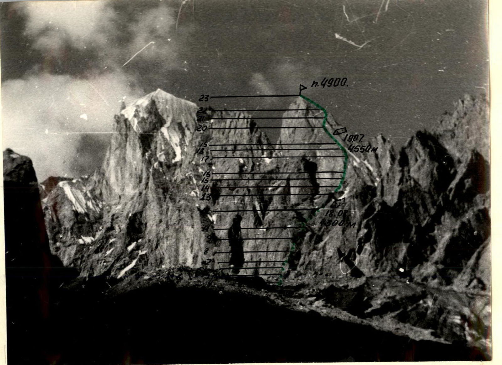
Area Map
Detailed Description of the Approach to the Route
Peak 4900 m is located in a spur of the Shugnan Range.
From the village of Vuzh, located on the Pamir Highway, 47 km from the city of Khorog, follow the serpentine road up to the Big Floodplain Meadow. This is a convenient place to set up a base camp.
From the base, follow the left (orographic) bank of the Noddera River to the junction of two gorges. The path lies into the right (in the direction of travel) gorge. First, follow the trail, and then steep talus terraces, alternating with smooth slabs, to the base of a large snow cone. Here, on grassy ledges, there are convenient, safe areas for a bivouac. From the base - 4-5 hours of walking.
TABLE of Main Characteristics of the Ascent Route
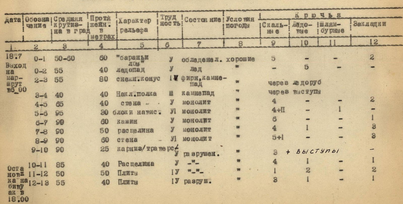
| Date | Designation | Average Steepness in Degrees | Length in Meters | Terrain Character | Difficulty | Condition | Weather Conditions | Rock | Ice | Bolt Pitons | Chocks |
|---|---|---|---|---|---|---|---|---|---|---|---|
| 07/18 Departure at 8:00 | 0–1 | 50–60 | 60 | «ram's foreheads» | U | icy | good | 5 | – | – | 2 |
| 0–2 | 55 | 40 | icefall | U | ice | – | 5 | – | – | – | |
| 2–3 | 55 | 80 | snow cone | 1U | névé, rockfall | «» | – | via ice axe | – | – | |
| 3–4 | 40 | 40 | inclined ledge | Ш | rockfall | «» | – | via outcrops | – | – | |
| 4–5 | 65 | 40 | wall | U | monolith | «» | 4 | – | – | 2 | |
| 5–6 | 95 | 30 | overhanging blocks | U1 | monolith | «» | 4+1 | – | 1 | – | |
| 6–7 | 90 | 60 | chimney | U | monolith | «» | 6 | – | – | 1 | |
| 7–8 | 90 | 50 | crevice | U | monolith | «» | 4 | 1 | – | 3 | |
| 8–9 | 90 | 60 | wall | U1 | monolith | «» | 5+1 | – | – | 3 | |
| 9–10 | 90 | 25 | cornice/traverse | U | destroyed. | «» | 3 + outcrops | – | – | – | |
| Stop for bivouac at 18:00 | 10–11 | 85 | 40 | crevice | U | «» | «» | 4 | 1 | – | 1 |
| 11–12 | 50 | 50 | slabs | 1U | «» | «» | 1 | 2 | – | 2 | |
| 12–13 | 55 | 40 | slabs | 1U | destroyed | «» | 3 | 1 | – | 1 | |
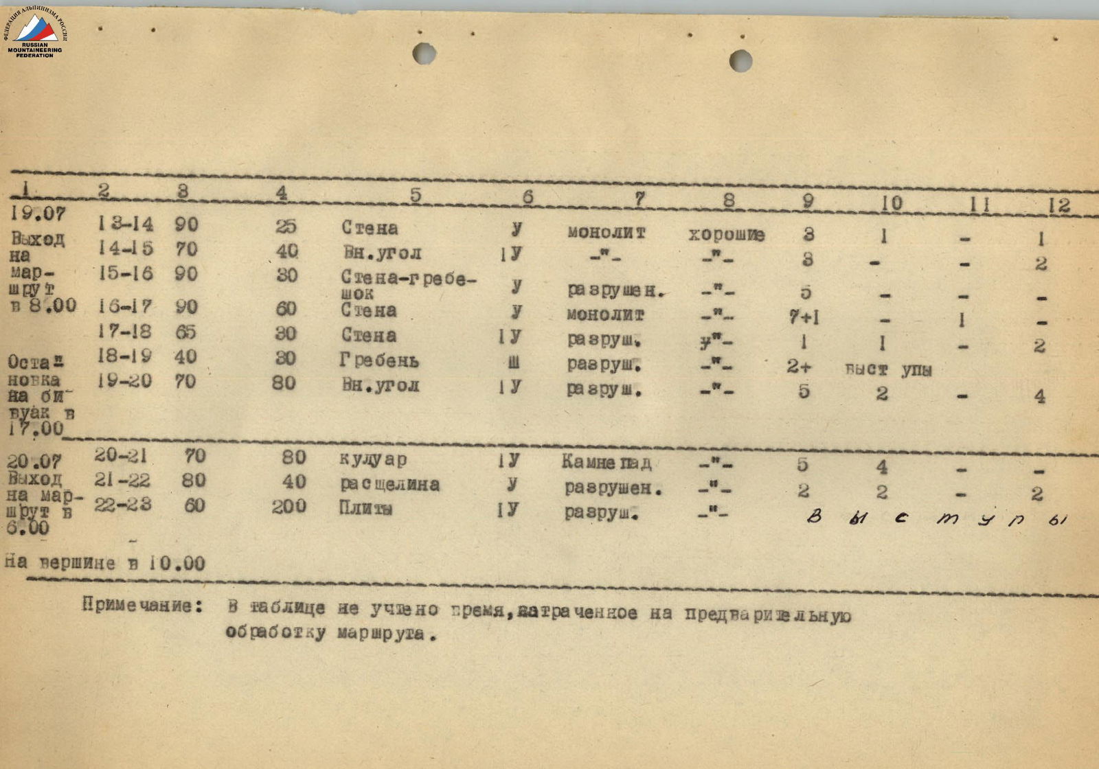
| 07/19 Departure at 8:00 | 13–14 | 90 | 25 | wall | U | monolith | good | 3 | 1 | – | 1 |
| 14–15 | 70 | 40 | inner corner | 1U | «» | «» | 3 | – | – | 2 | |
| 15–16 | 90 | 30 | wall-ridge | U | destroyed. | «» | 5 | – | – | – | |
| 16–17 | 90 | 60 | wall | U | monolith | «» | 7+1 | – | 1 | – | |
| 17–18 | 65 | 30 | wall | 1U | destroyed. | «» | 1 | 1 | – | 2 | |
| Stop for bivouac at 17:00 | 18–19 | 40 | 30 | ridge | 1Ш | destroyed. | «» | 2+ | outcrops | – | 2 |
| 19–20 | 70 | 80 | inner corner | 1U | destroyed. | «» | 5 | 2 | – | 4 | |
| 07/20 Departure at 6:00 | 20–21 | 70 | 80 | couloir | 1U | rockfall | «» | 5 | 4 | – | – |
| 21–22 | 80 | 40 | crevice | U | destroyed. | «» | 2 | 2 | – | 2 | |
| 22–23 | 60 | 200 | slabs | 1U | destroyed. | «» | 3 | 1 | s | 1 |
At the summit at 10:00
Note: the table does not take into account the time spent on preliminary route preparation.
Brief Explanation of the Table
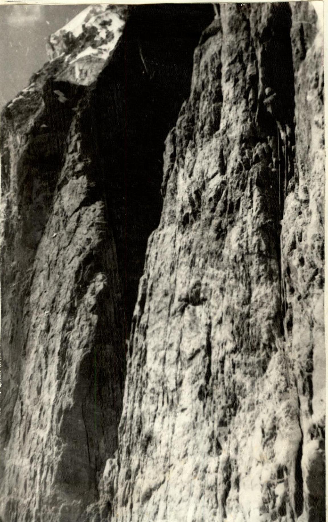
July 18. Departure at 6:00. From the grassy ledges, crossing the snowfield, we approach the icefall. Through the "ram's foreheads" on the border of ice and rocks, and then, overcoming 40 m of the icefall, we reach a steep névé slope. On it, avoiding crevasses, straight up to a steep talus ledge. On the ledge - a control cairn. Then up the wall to the black streaks. Further, overcoming 25 m of overhanging blocks (ITO), we reach a vertical chimney, narrowing at the top. After 40 m, we exit onto the outer wall of the chimney and then onto a small ledge (control cairn). From the control cairn, left and up along a large crevice, turning into a chimney. The left wall of the chimney is a large spall (feather). From the top of the feather, along a sheer, partially overhanging wall, 60 m up - under a black cornice. Then 25 m left under the cornice, we approach a crevice. Along it straight up, then along steep slabs (attention: loose rocks), we reach an inclined ledge. We stop for a bivouac at 18:00. The bivouac site is safe. We made a platform for one tent.
July 19: Departure at 8:00. Along the slabs, we move to a small saddle on the counterfort. Then, along a 25-meter wall, we exit onto the counterfort. (Attention: rocks are falling from the couloir on the right in the direction of travel - 1). Then along an inner corner and further along a 30-meter wall up, along a small ledge - onto the counterfort. (Attention: on the ledge, many large loose rocks - 1). From the ledge, along a gray 60-meter wall straight up (ITO) - to a small inclined ledge for one person. Then, along destroyed rocks, 30 m up, we exit onto the apex of the triangle crowning the counterfort. Bivouac site. At 17:00, we stopped for a bivouac. We laid out two platforms. Each can accommodate two people.
July 20, 1978. Departure at 6:00. Approaching a wide couloir (attention: rockfall!), we cross it as early as possible and exit onto the main ridge. From there, along a crevice up - to a small noisy gendarme. The gendarme is bypassed on the left. (Caution, many loose rocks). Then, along destroyed slabs, partially snow-covered, we reach the summit at 10:00. Descent via the ascent route.
Conclusions and Recommendations
The route to Peak 4900 m via the SE counterfort is predominantly rock. A little snow and ice at the beginning of the route and in its upper part make the route enjoyable for passage. Strong monolithic rocks (in the first and throughout the route) allow the use of a wide range of pitons. These are:
- combined rock pitons;
- VTsSPS and channels of various types;
- chocks;
- ice VTsSPS.
The route is logical, unambiguous, and safe throughout. It can be compared with the following routes of 5A cat. diff., passed by group members:
- Peak Asham via the 3rd wall;
- Peak Tekelik via the 3rd wall.
The route passed is more challenging than the following routes of 5A cat. diff., passed by group members:
- Dombay - Ulgen Western;
- from Dombay Pass;
- Brigantina via the N. ridge.
The coach and ascent participants believe that the route to Peak 4900 m via the SE counterfort with an exit via the S. wall corresponds to 5A cat. diff.
Team Captain (Leontyev V.G.)