
ASCENT DOCUMENT
I. Technical Class.
- South-West Pamir, Shugnan Ridge.
- Traverse of peaks Dzhirain (5329 m) and 5100 m with ascent to peak Dzhirain via the South-East buttress.
- Estimated difficulty category 5B.
- Route characteristics:
height difference: 1400 m (Dzhirain), 400 m (p. 5100) section length:
- total 3500 m
- 5th category 325 m
- 6th category 80 m
average steepness 57° (Dzhirain), 45° (p. 5100)
-
Pitons used for belaying: for creating ITO: rock — 98–7 ice — 16 bolts — 1–1 chocks — 59–3
-
Total climbing hours — 32.
-
Number of nights — 2, on snow, in a tent.
-
Group composition: Staritskiy P.I. — Candidate for Master of Sports, instructor-leader Gorbenko M.M. — Candidate for Master of Sports, instructor-participant Serpak A.A. — Candidate for Master of Sports, instructor-participant
-
Coach — Master of Sports, senior instructor Sviridenko V.S.
-
Departure to the route July 26, 1978, return July 28, 1978.
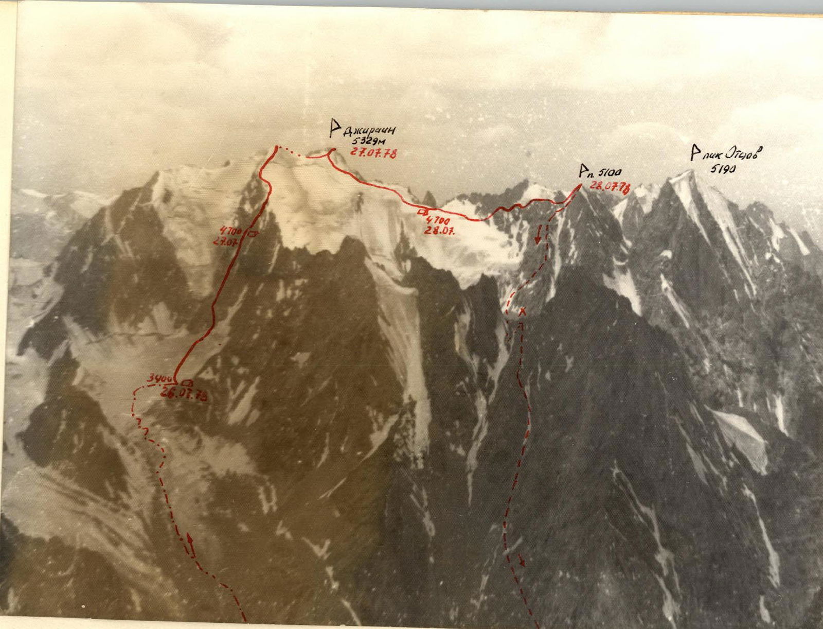
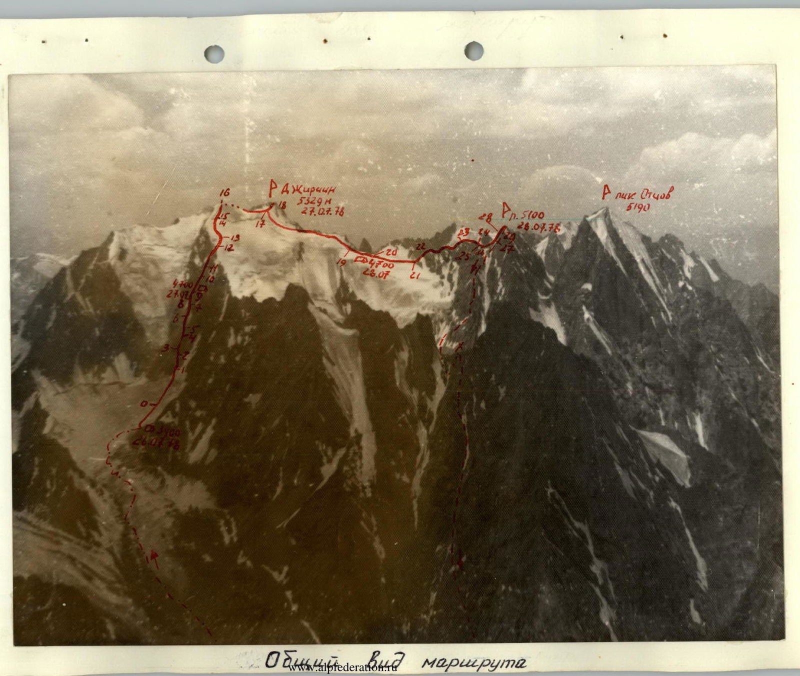
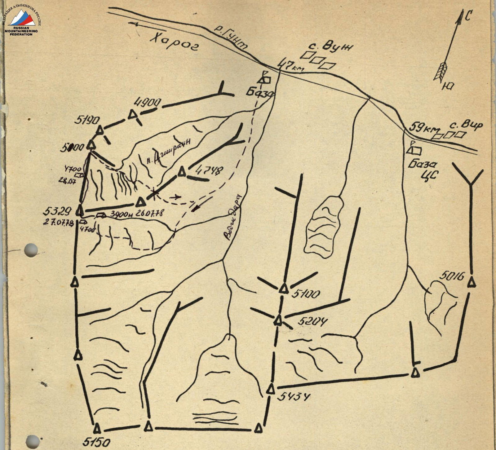
Area map Peaks Dzhirain (5329 m) and 5100 m are located in the Shakhdarin Ridge and dominate the Vodjdara river valley (left tributary of the Gunt river).
Brief description of the approach to the route
It is convenient to set up a base camp on the left bank of the Voljpara river near the village of Vodzh (47 km of the Pamir Highway from Khorog) on a large green meadow. From here, 2 hours upstream along the left, heavily rugged bank of the Vodjpara river without a trail to the confluence of two large tributaries. Steeply to the right and along the left-bank moraine of the left tributary and a large scree slope, ascent to the tongue of the glacier, originating from the slopes of peak Dzhirain (1 hour).
Enter the glacier from the left, traverse to the middle and ascend, avoiding crevasses, to the upper plateau.
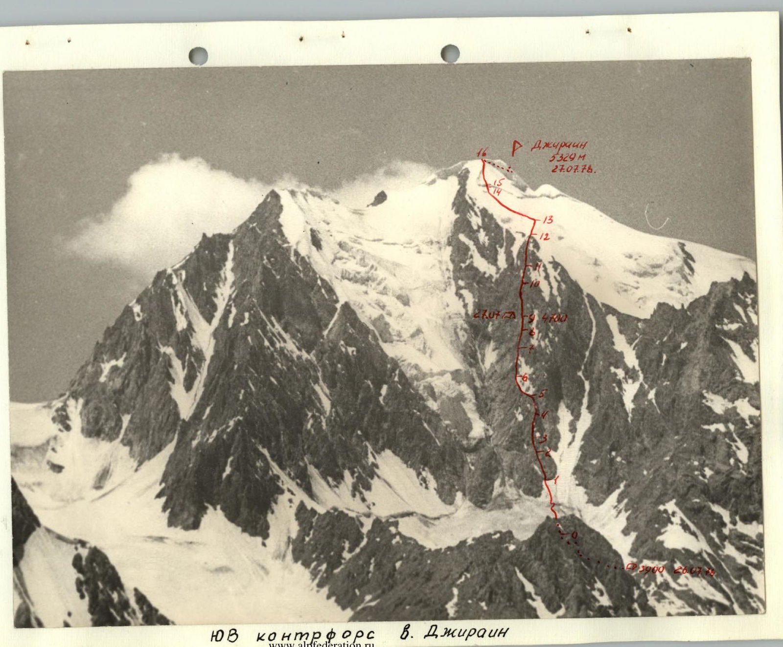
On the left-bank moraine of the glacier at an altitude of 3900 m is the initial bivouac (1 hour). From here, traverse the upper plateau of the glacier in the direction of a large snow-ice cone with a wide bergschrund at the top — the start of the route along the SE buttress of peak Dzhirain (0.5 hours).
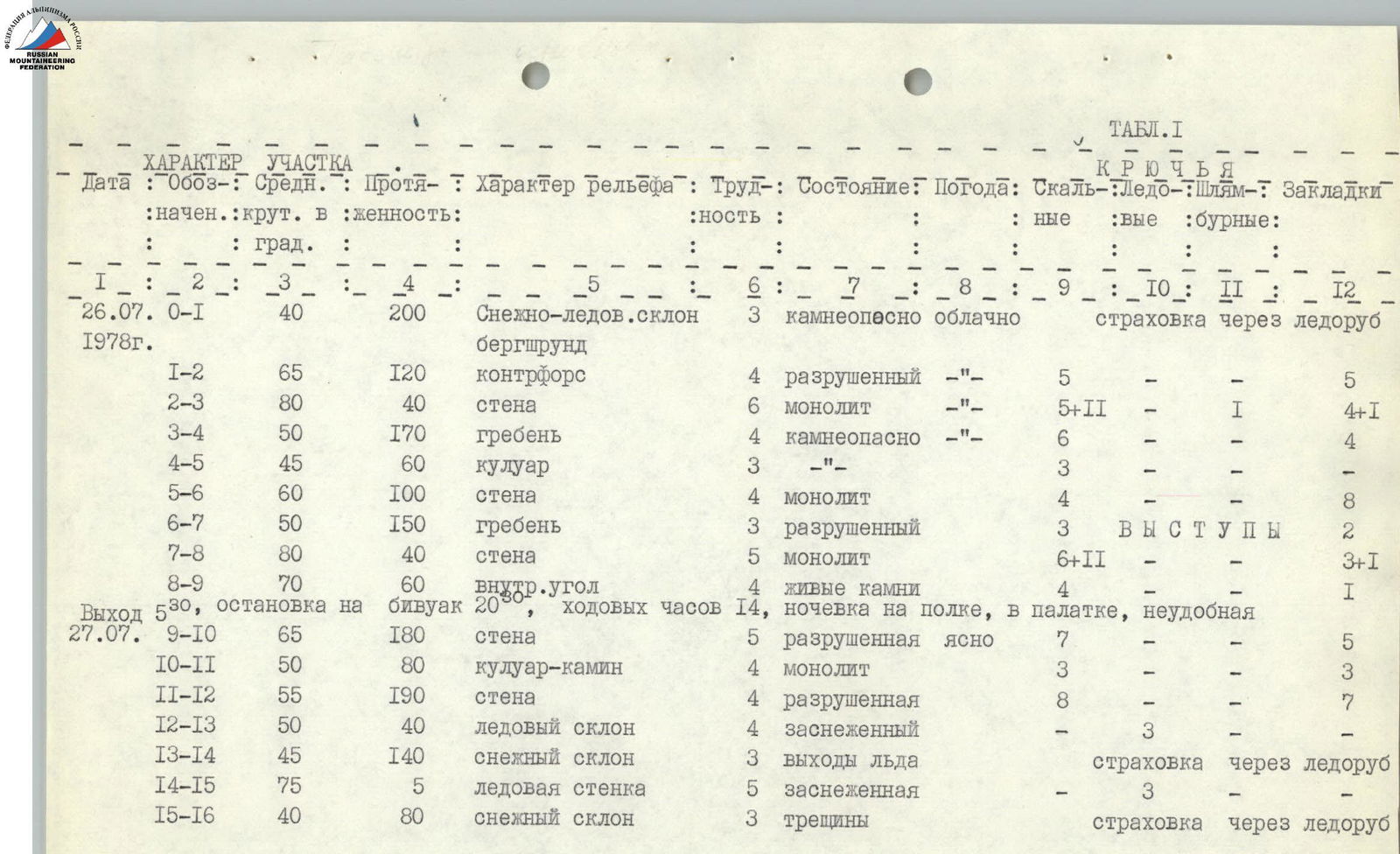
Brief explanation of the table
July 27, 1978. Departure at 5:30. Ascent along the snow-ice cone in crampons. The upper edge of the bergschrund overhangs. A single narrow bridge in the middle part of the bergschrund. From here, a rope leads up and left (in the direction of travel) to the rocks of the buttress. Descent into a randkluft and via complex rocks — exit onto the buttress, which leads to the key section — the rusty wall. The wall is traversed from left to right. At the top, an overhang, using artificial holds and ladders. Rope hauling. Along a narrow couloir (rockfall hazard) to the next wall, which is traversed in the center. Exit into a couloir (rockfall hazard), which abuts a gray, crumbling bastion — a jumble of short, steep walls. Further along an easy ridge to the second key point — a sheer, monolithic wall, divided in the middle part by a narrow ledge into two parts. In the lower part, it is convenient to use chocks. Exit onto the ledge from the left, bypassing a small cornice. Rope hauling. Along a steep inner corner up to a characteristic black gendarme. Cairn. A little higher — a bivouac site, on a scree ledge. Water available (small snowpatch) — 20:30. July 28, 1978. Departure — 7:00.
Climbing time: 14 hours
TABLE 1 Section characteristics. Pitons.
| Date | Section | Steepness, ° | Length, m | Terrain characteristics | Difficulty | Condition | Weather | Rock pitons | Ice pitons | Bolt pitons | Chocks |
|---|---|---|---|---|---|---|---|---|---|---|---|
| July 26, 1978 | R0–R1 | 40 | 200 | Snow-ice slope, bergschrund | 3 | rockfall hazard | cloudy | belay via ice axe | |||
| R1–R2 | 65 | 120 | buttress | 4 | crumbling | 5 | |||||
| R2–R3 | 80 | 40 | wall | 6 | monolithic | 5+2 | 1 | 4+1 | |||
| R3–R4 | 50 | 170 | ridge | 4 | rockfall hazard | 6 | 5 | 4 | |||
| R4–R5 | 45 | 60 | couloir | 3 | 3 | ||||||
| R5–R6 | 60 | 100 | wall | 4 | monolithic | 4 | 8 | ||||
| R6–R7 | 50 | 150 | ridge | 3 | crumbling | 3 | outcrops | 2 | |||
| R7–R8 | 80 | 40 | wall | 5 | monolithic | 6+2 | 3+1 | ||||
| R8–R9 | 70 | 60 | inner corner | 4 | loose rocks | 4 | 1 | ||||
| Departure 5:30, stop at bivouac 20:30, climbing hours 14, overnight on a ledge, in a tent, uncomfortable | |||||||||||
| July 27, 1978 | R9–R10 | 65 | 180 | wall | 5 | crumbling | clear | 7 | 5 | ||
| R10–R11 | 50 | 80 | couloir-chimney | 4 | monolithic | 3 | 3 | ||||
| R11–R12 | 55 | 190 | wall | 4 | crumbling | 8 | 7 | ||||
| R12–R13 | 50 | 40 | ice slope | 4 | snow-covered | 3 | |||||
| R13–R14 | 45 | 140 | snow slope | 3 | ice outcrops | belay via ice axe | |||||
| R14–R15 | 75 | 5 | ice wall | 5 | snow-covered | 3 | |||||
| R15–R16 | 40 | 80 | snow slope | 3 | crevasses | belay via ice axe |
Continuation: Ascent along the crumbling wall up and left to a wide, long chimney. Inner climbing. The last 20 m up along the right side of the chimney. The rock bastion is traversed on the right, near a rockfall-prone couloir. Further along the crumbling wall — exit onto the east ridge of peak Dzhirain.
Further along the ice wall — exit onto the snow-ice dome of the peak. Along the snow slope up ( местами open ice) to an ice drop, which is traversed on the left along the ice wall. Exit onto the dome of the subpeak. The highest point of the peak is located west of the subpeak and represents a rugged rock ridge.
A slight descent from the subpeak into a depression, where we leave the backpacks, and along it to the rocks, which lead to the peak. Cairn 13:30.
From the peak, descent via rappel into the depression and exit onto a snow terrace, further down along the north ridge of peak Dzhirain in the direction of peak 5100 m.
Along the snow-ice slope, avoiding crevasses, we exit onto the saddle between peak Dzhirain and peak 5100 (18:00). Bivouac on snow, comfortable. Climbing hours: 10.
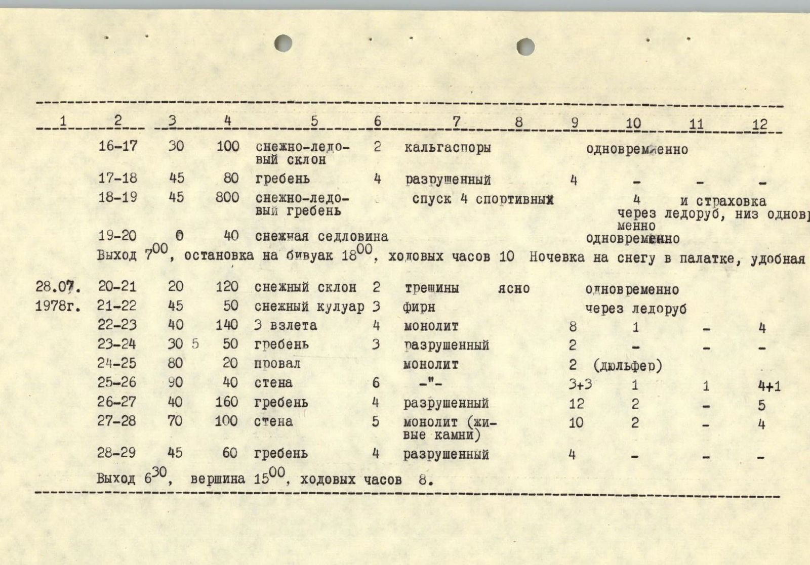
| Date | Section | Steepness, ° | Length, m | Terrain characteristics | Difficulty | Condition | Weather | Rock pitons | Ice pitons | Bolt pitons | Chocks |
|---|---|---|---|---|---|---|---|---|---|---|---|
| R16–R17 | 30 | 100 | snow-ice slope | 2 | glazed ice | simultaneous | |||||
| R17–R18 | 45 | 80 | ridge | 4 | crumbling | 4 | |||||
| R18–R19 | 45 | 800 | snow-ice ridge | descent 4 sports | 4 | and belay via ice axe, lower simultaneous | |||||
| R19–R20 | 0 | 40 | snow saddle | simultaneous | |||||||
| Departure 7:00, stop at bivouac 18:00, climbing hours 10. Overnight on snow in a tent, comfortable. | |||||||||||
| July 28, 1978 | R20–R21 | 20 | 120 | snow slope | 2 | crevasses | clear | simultaneous | |||
| R21–R22 | 45 | 50 | snow couloir | 3 | firn | via ice axe | |||||
| R22–R23 | 40 | 140 | 3 pitches | 4 | monolithic | 8 | 1 | 4 | |||
| R23–R24 | 30 | 50 | ridge | 3 | crumbling | 2 | |||||
| R24–R25 | 80 | 20 | drop | monolithic | 2 (rappel) | ||||||
| R25–R26 | 90 | 40 | wall | 6 | -"- | 3+3 | 1 | 1 | 4+1 | ||
| R26–R27 | 40 | 160 | ridge | 4 | crumbling | 12 | 2 | 5 | |||
| R27–R28 | 70 | 100 | wall | 5 | monolithic (loose rocks) | 10 | 2 | 4 | |||
| R28–R29 | 45 | 60 | ridge | 4 | crumbling | 4 | |||||
| Departure 6:30, peak 15:00, climbing hours 8. |
July 29, 1978. Departure at 6:30. Continuing the traverse, we exit onto the south ridge of peak 5100, bypassing the first rock bastion on the right along the snow. Three rock pitches are traversed "head-on", further along a simple, crumbling ridge, we approach a drop, descent via rappel onto a small ledge. From here, straight up along a sheer, monolithic wall, the lower part of which is completely smooth — the key section. After the wall — traverse of a steep rock ridge to a gendarme. Ascent "head-on", descent via rappel. Along a long inner corner, we bypass a crumbling, rockfall-prone bastion and exit onto a ridge, which abuts a main wall. Smooth rocks and the presence of "loose" rocks complicate the passage of this wall. The wall leads to the east ridge of peak 5100. We leave the backpacks and ascend along the crumbling east ridge to the peak 5100 m. Cairn 15:00. Climbing hours: 8.
Descent along the east ridge:
- 4 sports and 2 rappels to the lower plateau of the Dzhirain glacier.
- Traverse the glacier in the direction of a clearly defined saddle in the east spur of peak Dzhirain.
- Along the snow slope to the saddle, descent along a long couloir into the Vodzh river valley.
- Descent along the ascent route to the Base camp.
- Descent takes 8–10 hours.
Descent from the lower plateau of the Dzhirain glacier through a difficult-to-pass icefall is hazardous and not recommended for descent to the Base camp.
Conclusions and recommendations
The traverse of peaks Dzhirain and 5100 m is a first ascent of both peaks. The ascent along the SE buttress of peak Dzhirain is the most technically complex and labor-intensive section of the entire traverse.
The choice of route — traverse of two peaks — is explained by the logical connection of these peaks and a convenient descent from peak 5100 to the lower plateau of the Dzhirain glacier.
The traverse was completed in good weather conditions, which allowed the route to be completed in 3 days.
This route is technically more complex and psychologically more demanding than the well-known traverses of Ushba and Dombay.
The ascent along the SE buttress of peak Dzhirain is similar to routes of 5B category in the SW Pamir region:
- peak Borovikova along the S edge
- peak Luknitskogo along the SW edge.
The coach and the group believe that the completed traverse corresponds to the 5B category.
GROUP LEADER
 P. STARITSKIY
Comments
Sign in to leave a comment