
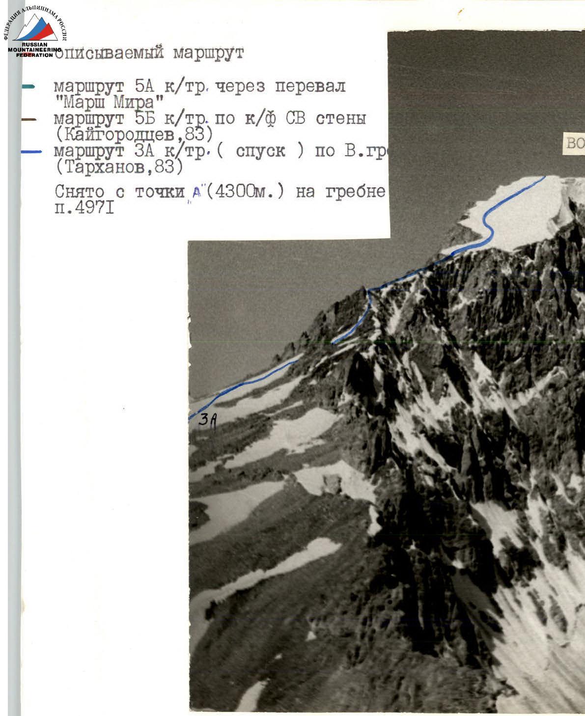
Ascent Log
- Class — ALPINE-TECHNICAL
- Ascent Region — SOUTHWEST PAMIR SHUGNAN RANGE
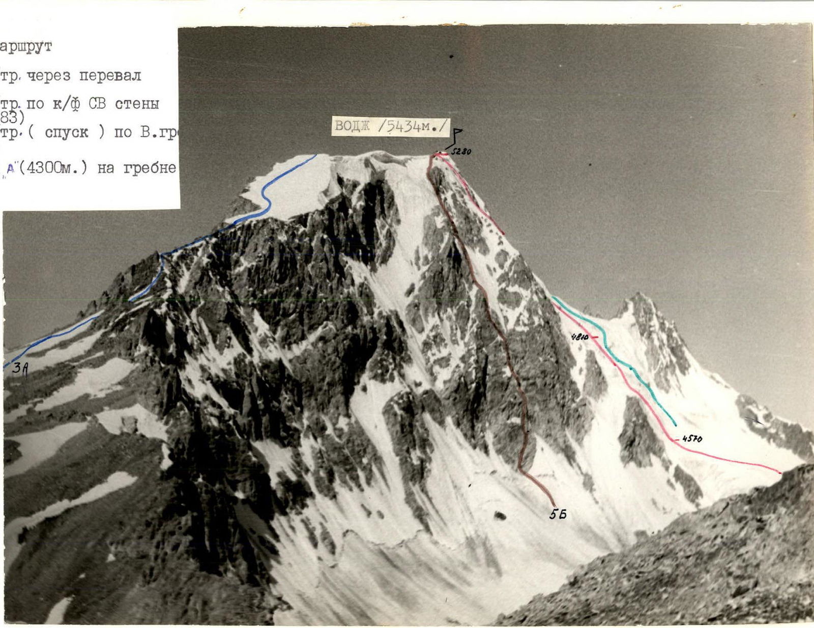
- Object — peak VODJ 5434 m
- Route — via the left part of the north face ice-snow first ascent
- Proposed difficulty category — 5A
- Height difference: 864 m — total (by altimeter) 710 m — wall section of the route
- Length: 1070 m — total 920 m — wall section of the route
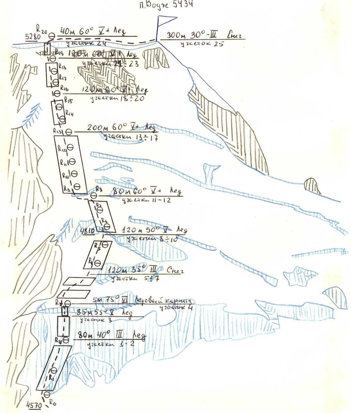
- Average steepness: 53° — wall section of the route 45° — from elevation "4570" to "4810" 60° — from elevation "4810" to "5280"
- Ice screws used: for belay — 118 pcs. for creating T.P. — 3 pcs.
- Number of climbing hours (ascent) — 10 h
- Team composition:
Leader — Yuri Ivanovich Kocherga — 1st sports category
Participants:
- Sergey Alexandrovich Kaygorodtsev — Candidate Master of Sports
- Igor Grigorievich Mosiychuk — Candidate Master of Sports
- Sergey Vladislavovich Shidlovsky — Candidate Master of Sports Team Coach — Master of Sports Vladimir Grigorievich Tarkhanov
- Date of departure on the route — August 16, 1983 Date of return — August 16, 1983
Chelyabinsk Region Alpine Federation, 1983 year
6 climbing hours
| Designation | Average steepness, degrees | Length, m | Terrain characteristics | Difficulty | Condition | Weather conditions | Ice | Rock |
|---|---|---|---|---|---|---|---|---|
| 10:00–16:00 | ||||||||
| R0–R1 | 70 | 40 | rocky inner corner | IV | destroyed rocks | clear, sunny | – | 5 |
| R1–R2 | 80 | 10 | rocky wall | IV | monolith | –"— | – | 2 |
| R2–R3 | 45 | 160 | rocky ridge | II | destroyed rocks | –"— | – | – |
| R3–R4 | 30 | 120 | wide snowy ridge | II | soft deep snow | –"— | – | – |
| R4–R5 | 40 | 80 | snowy ascent | III | –"— | –"— | – | – |
| R5–R6 | 20 | 40 | snowy ridge | III | –"— | –"— | – | – |
| R6–R7 | 40 | 40 | snow-ice ascent | III | ice covered with a thin layer of snow | –"— | – | – |
| R7–R8 | 20 | 160 | snow-ice ridge | II | –"— | –"— | – | – |
| R8–R9 | 40 | 80 | snow-ice ascent | III | –"— | –"— | – | – |
| R9–R10 | 30 | 120 | snow-ice ridge | II | –"— | –"— | – | – |
| R10–R11 | 45 | 40 | ice wall | IV | porous ice | –"— | 3 | – |
| R11–R12 | 25 | 30 | snowy ridge | II | soft deep snow | –"— | – | – |
| R12–R13 | 45 | 10 | snow-ice wall | IV | ice covered with a thin layer of snow | –"— | – | – |
| R13–R14 | 20 | 40 | rocky ridge | II | destroyed rocks | –"— | – | – |
Descent via the ascent route. 2 rappels were organized during the descent:
- Rappel 1
- Rappel 2
Descent took 2 hours.
 |
|---|
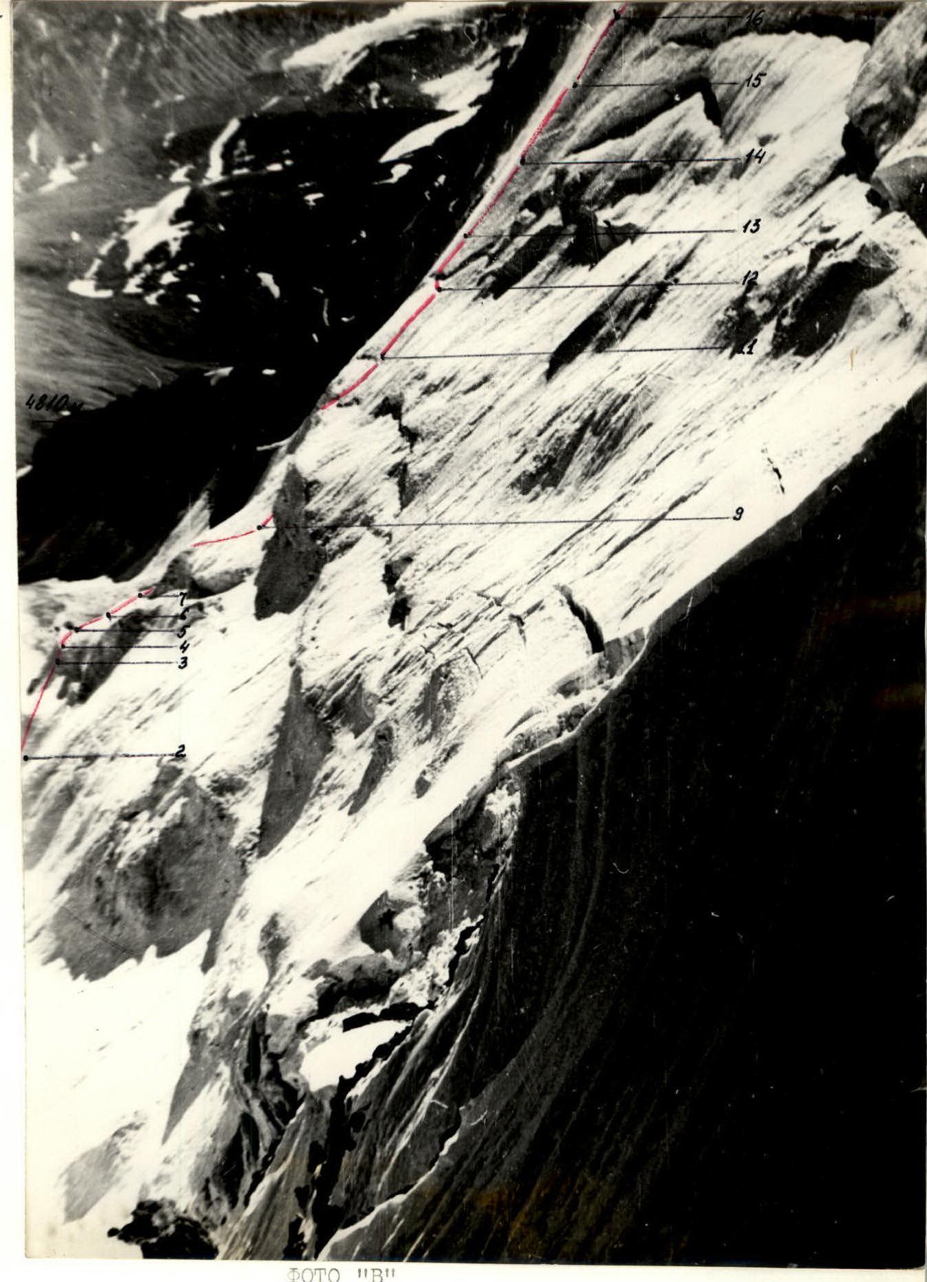
Right profile of the lower part of the route from a distance of 1 km. Photo taken on August 22, 1983 at 12:00, "Helios 44-2" (F = 56 mm). See also photos # 2, 3, 5 in the report of A. Fedlev's group, peak VODJ via the N face through the "Marsh Miro" pass (pp. 3–3a–5).
Route diagram in UIAA symbols

Descent along the long eastern ridge, category 3A, to the saddle with peak 4971. Took the group 2 hours 30 minutes.
CLASSIFICATION PROPOSALS: The group was trained in the "Dzhailyk" alpine camp and spent the season in the Karakol gorge. They believe that the new route they completed is comparable to the most difficult and challenging ice and snow sections of Ullu-Tau-Chany and Slonenk. With the gain in altitude, it becomes increasingly demanding and requires thorough belaying and self-belaying. Therefore, it is proposed to include it in the KTMGV USSR: peak Vodj 5434 5A snow-ice via the left part of the N face, Yu. Kocherga, 1983.
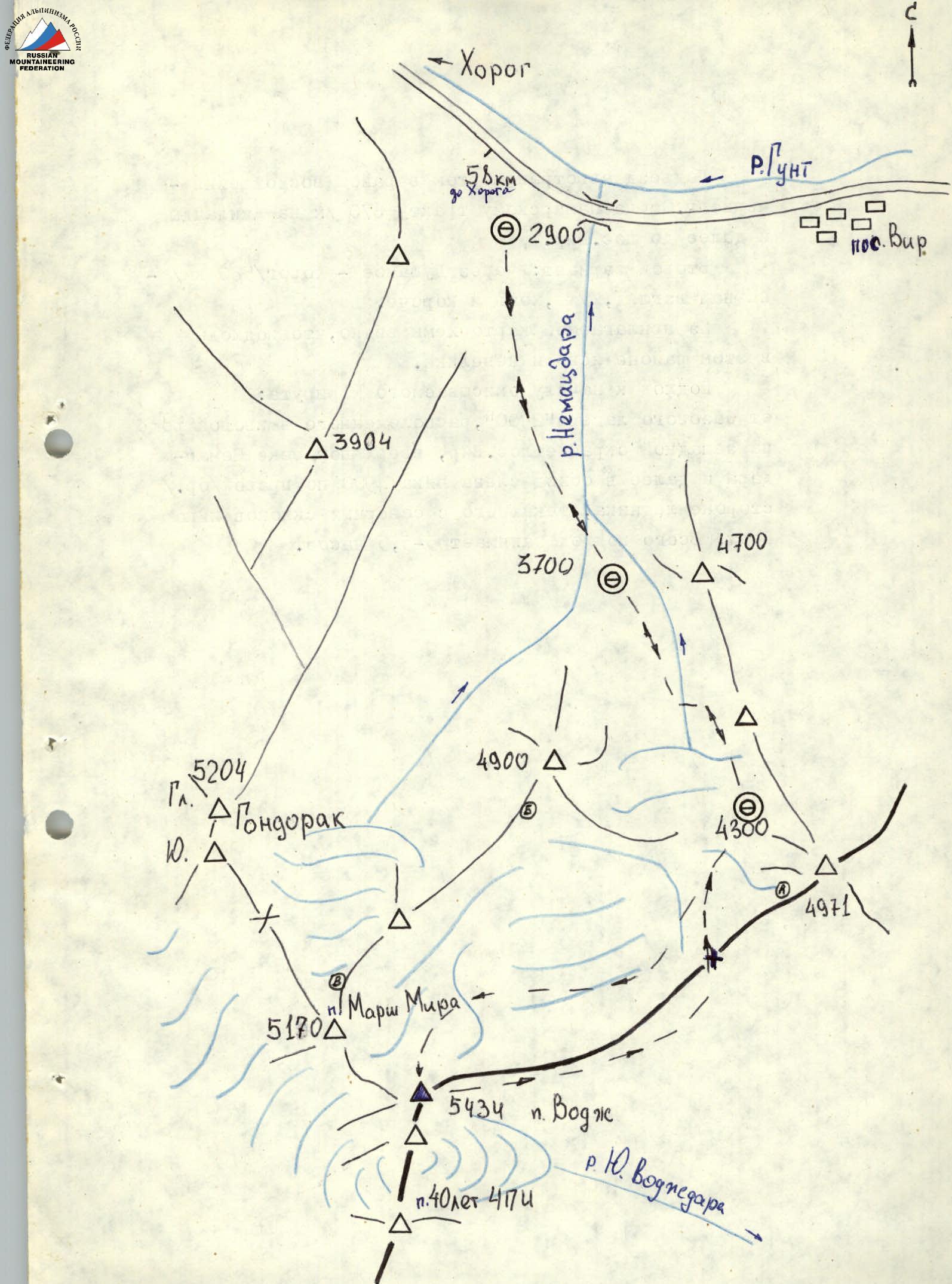
Approach by vehicle to the ascent region: through the city of Osh along the Pamir highway 670 km to Dzhelandy and further to the village of Vir. The second option: through Dushanbe — Khorog (580 km) — in our opinion, is worse, although shorter. From the attached map diagram, it is clear that the approaches in this area are straightforward and not long. Approach to the start of the described route: from the base camp "2900", located in a willow grove on the western outskirts of the village of Vir, up the Nematsdara river and then bypassing peak 4900 on the left, on the right (or.) side of the glacier flowing from the northern slopes of peak Vodj. The total approach takes 5–5.5 hours.
Comments
Sign in to leave a comment