Ascent Log
-
Ascent class — high-altitude and technical.
-
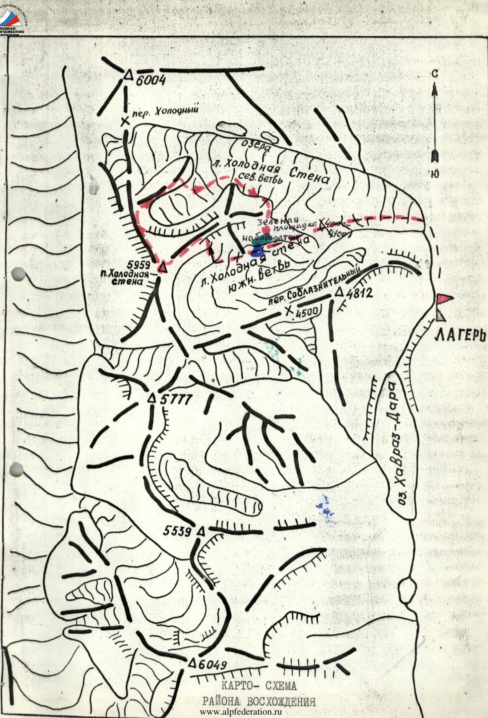
Ascent area — Yazgulem Range, Central Pamir.
-
Peak, its height, ascent route — Peak Kholodnaya Stena, 5959 m. Eastern wall (right part).
-
Expected difficulty category — 6
-
Route characteristics: height difference — 1700 m, length of sections with 5–6 difficulty level — 1299 m, average steepness — 80°
-
Number of driven pitons: for belaying, for creating artificial footholds: rock — 388/17 ice — 30/2 bolted — 1
-
Number of walking hours — 139
-
Number of overnight stays and their characteristics Total overnight stays — 11, of which: in a tent — 8 semi-reclining, separate — 1 sitting, separate — 2
-
Surname, name, patronymic of the team leader, participants, and their qualification.
- Shumilov Oleg Ivanovich — Master of Sports of the USSR, team leader and coach.
- Vekslar Valery Yakovlevich — Master of Sports of the USSR, deputy team leader.
- Kadtsin Vladimir Nikolaevich — Candidate for Master of Sports.
- Kreitsberg Alexander Erikovich — Candidate for Master of Sports.
-
Team coach Shumilov Oleg Ivanovich.
-
Date of departure and return Departure August 6, 1980. Return August 23, 1980. Of these, August 9, 13, 18, and 19 were non-working days due to snowfall and bad weather.
Mor-191-60
-
Tactics of the Ascent
Due to the fact that on July 29, the team captain, Gorodetsky E.M., fell ill, the team, due to the required 4.5 score for the right to participate in the USSR Alpine Championship, was forced to remain in a composition of 4 people. This circumstance complicated the work on the route for the team members and, accordingly, left its mark on the developed tactical plan for the ascent, which provided for the following:
- Places for overnight stays under overhangs were to be carefully chosen so that the team could fully rest psychologically during rest. For this purpose, 10 domestic 10mm ropes were taken to organize fixed ropes from bivouac to bivouac, as well as for "insurance". Movement along the fixed ropes was carried out in "links" on imported 12mm ropes, which are more elastic than domestic ones.
- Departure on the day of processing and the first day of ascent on the route started at 14:00, when the rockfall danger on the wall decreased.
- Since the bivouac equipment had to be divided among 4 people instead of 8, it was necessary to vary different tactics for passing complex sections of the route on the spot, for example: a) One pair processes the route, the second pair brings equipment, and then removes the fixed ropes. The whole group removes the bivouac and transfers it to the next overnight stay location. b) The group moves simultaneously, immediately removing the bivouac. The lead climber goes without a backpack. The other three distribute the remaining load among themselves, except for the equipment being used. c) The lead climber goes with a lightened backpack. The trailing pair removes the bivouac, brings equipment, and then removes the fixed ropes, etc.
- The use of modern lightweight equipment, namely: titanium pitons, carabiners, crampons, as well as ice axes, rock hammers, or ice axes with a specially profiled beak shape. In addition, the links worked on imported 12mm ropes, 45 m in length.
- The final composition of the assault group was selected by doctors and coaches based on the best physical indicators. All have extensive experience in joint ascents to peaks of 5B and 6B difficulty categories. Shumilov O.I. and Vekslar V.Ya. have ascents to peaks of 6B category: OGPU (2nd place in the USSR Championship 1972), Chapdara via the North face (Salonnikov), Zindon via the North face (Emelyanenko), Zindon via the Center of the North face (2nd place in the USSR Championship 1977), Bodkhona via the West face (Kolchina); Kreitsberg A.E. and Kadtsin V.N. have ascents to peaks of 5B category: Shkhelda (via Rybka), Festivalnaya — Slonelyok, Volnaya Ispaniya (Myshlyaeva), Tyu-Ty 2nd Western (Khergiani's bastion), 2nd Shkhelda Southern (Akhтырского), Maria via the North face (Vinokurova), Rudaki via the North face (Vinokurova). Vekslar V.Ya., Kreitsberg A.E., Kadtsin V.N. made a joint ascent this year to the peak of Tyninkina via the West face, South-West spur — 4B category, and to the peak of Lokomotiv via the Center of the North face — 5A category (approximately), a first ascent.
- For the ascent, a selection of products was planned, calculated at 300–350 g per person per day for 12 days. Therefore, special attention was paid to their composition and calorie content. The team had special products: nuts, nuts with prunes, honey, dried apricots, raisins, dried fresh herbs, lard. To compensate for the lack of vitamins, garlic, onions, ascorbic acid, and glucose tablets were taken in sufficient quantities. There was also plenty of tea and a reserve of gasoline for obtaining the necessary amount of water.
Expecting good weather, a tactical plan was drawn up for the ascent, calculated for 10–12 days:
- 1 day — route processing
- 2–3 days — passage of the first belt of rocks "feathers"
- 2–3 days — passage of the second belt of rocks "embryo"
- 4 days — passage of the third main belt of rocks
- 1 day — passage of the snow-ice section along the ridge
Since during the team's time on the route, there was strong bad weather with abundant snowfall (a total of about 1.5 m for all days of bad weather) and a sharp cooling on the final stage of the ascent, and the steepness of the slopes chosen for the route turned out to be somewhat greater than the preliminary assessment, the actual passage of the route (excluding non-working days during the period of waiting out the bad weather on August 9, 13, 18, and 19) took 14 days and 1 day of processing.
Comparing the preliminarily planned route and the one actually taken, and taking into account:
- the number of people in the team, which increases the labor intensity of the work on the route for each group member,
- the weather conditions in which the group found itself,
compared to the teams of the Central Council of the "Trud" Sports Society and the Central Council of the "Burevestnik" Sports Society, it can be said that the TACTICAL PLAN FOR THE GROUP'S MOVEMENT WAS, IN ITS ESSENCE, MAINTAINED.
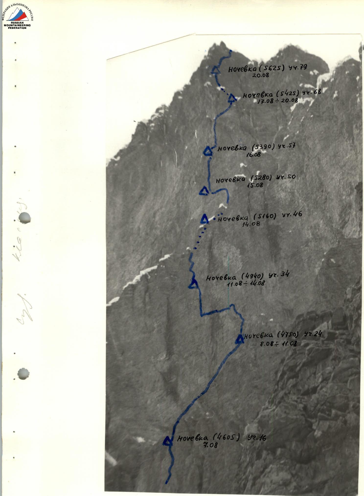
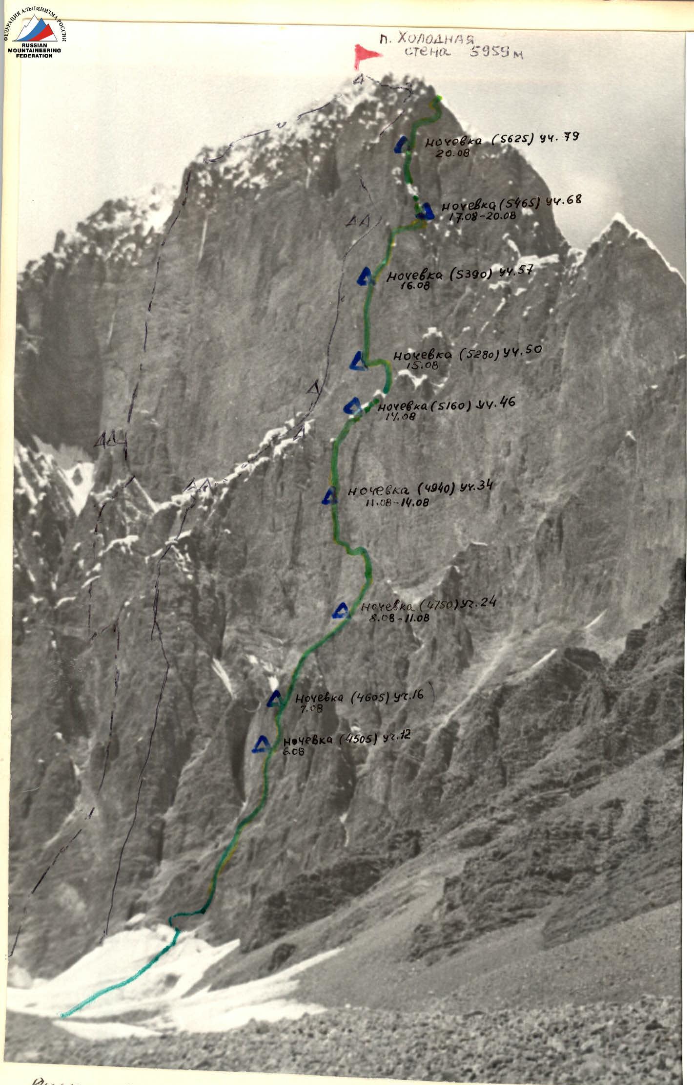
Photo from the East spur of p. Kholodnaya Stena (semi-profile)
Description of the Ascent Route
August 5
Ascent at 7:00. After reconnaissance of the approaches to the beginning of the route, identification, and final clarification the day before of a safe area of the wall from rockfall, the lead pair starts processing the route at 14:00. If initially the path passes through a firn slope with a slope of up to 50°, then after 60 m, it is necessary to overcome the bergschrund along an ice-snow wall with a slight negative slope and then move through an ice "clutter". At this point, a rock overhang нависает over the bergschrund slope with an outreach of up to 3 m, which provides some safety from rockfall during the initial ascent onto the rocks. The overhang is bypassed initially along a sheer wall, and then by traversing to the right, thereby beginning the ascent onto the rock section of the route. Work on the rocks shows that, despite the safety of the route from upper rockfall, as it passes on the sides of the middle "feather", it is dangerous due to its non-monolithic structure.
The rocks are heavily destroyed, initially consisting of "feathers", and then of rock "blocks" with a small number of cracks. In addition, their steepness at the base is about 70°, and in the upper part, it reaches 80° and 90°. All this creates increased tension when passing this route.
Despite this circumstance, on the day of processing, it is possible to pass more than 300 m and reach a ledge where it is possible to organize at least a sitting overnight stay.
Therefore:
- Tomorrow it is possible to exit onto the route
- With the gathering of all bivouac equipment
From this day on, communication between the assault group and the outside world will be maintained only through observers via radio.
August 6
As on the previous day, the group exits onto the route at 14:00, which is associated with the time of the least rockfall activity from the wall, which does not seem to stop for a second. We pass the bergschrund, where rockfall is particularly dangerous. When exiting onto the rocks, the danger from rockfall decreases, as stones pass on both sides of the intended path. On this day, it is possible to pass above the section processed the day before only about 80 m, which is due to the increased steepness of the rocks to 90°, the laboriousness of pulling up the bivouac, but still manage to reach the next platform, where it will be possible to ensure a comfortable lying overnight stay the next day. However, on this day, the overnight stay is organized on a ledge, sitting, separately: three in a tent and one in a bivouac sack in a suspended state.
August 7
We start work at 8:00 with pulling up backpacks to the upper platform. This takes considerable time. However, after the group exits onto the platform where the bivouac will be organized, the lead pair continues to move upward.
On this day, it is possible to reach the top of the first belt of rocks — "feather", which is crowned with a snow-ice "cap". During the day, it thaws, so passing the couloir when exiting onto the top of the "feather" presents significant difficulties. The first person works in galoshes. The couloir is filled with water during the day and is clogged with ice. On this section, ladders are used for passage.
After exiting above the "feather", the steepness of the slopes decreases to 50–60°, and the path passes along a ridge consisting of slab-like, also heavily destroyed rocks. The ridge represents the right edge of the couloir, separating the belt of rocks of the "feathers" series and the second belt of rocks under the conditional name "embryo" (due to the shape of the gray spot located in the upper part of this belt of rocks). The second belt of rocks нависает over the couloir.
When exiting onto the ridge, we can see the further path of movement along the second belt of rocks — "embryo". However, it is time to return down for the night.
For the day, 130 m were passed, which took 10 hours of work.
August 8
The lead pair continues to move upward at 8:00, while the second pair prepares the bivouac for transfer and removes the lower fixed ropes. On this day, we manage to approach closely to the belt of rocks "embryo", examine, and outline the beginning of the path to overcome this complex section of the route planned by us for passage. The "embryo" wall is a нависающий belt of rocks with an outreach in the upper part of up to 15–20 m and even more. On the one hand, this ensures the safety of movement along them (stones fly over, water spray and small ice fragments falling from above are also not dangerous), on the other hand, it creates excessive technical difficulty for their overcoming.
For the day (10 hours of work), 125 m were passed, and the bivouac was transferred to the upper section of the ridge, from where it is possible to process the "embryo" belt of rocks. However, the weather does not please us. By 18:00, the cloudiness increases, and snowfall begins. This circumstance makes us cautious, as wet rocks, not to mention those under a snow cover, become difficult to pass.
August 9
Snowfall continues throughout the night. In the morning, its thickness reached 30–35 cm.
We request a long-term weather forecast via radio. We have to:
- revise the tactical plan of the group's movement;
- conduct a revision of products and gasoline;
- allocate a reserve stock for possible days of bad weather.
However, the group's morale remains very high. The deterioration of the weather did not affect it in any way. Throughout the day, the snow cover did not completely melt, although the clouds parted by evening, and the sun appeared.
August 10
We want to make up for the lost day. Snow still partially lies on the rocks, but the pair begins to move upward. The steepness of the rocks is significant with overhangs, although the rocks are also destroyed and consist of quartz blocks of various sizes with a small number of cracks. This complicates the use of large pitons (channels and universal ones of large thickness) for organizing belays. Small petal-shaped pitons hold well, but it takes a lot of time to find small cracks.
For passage, the following are used:
- ladders.
In addition, movement is complicated by:
- water flows on the route.
Still, by evening, the pair reached an outcrop where it is possible to organize a decent overnight stay — semi-reclining, separate — and passed the first half of the complex "embryo" belt of rocks.
Tomorrow, it is planned to pull the bivouac up to the outcrop and use it as a starting point for overcoming the second half of the "embryo" belt of rocks. On this day, 140 m of complex rocks were passed in 12 walking hours.
August 11
For 10 hours of work on this day, we pulled the bivouac up to the outcrop using the withdrawal of backpacks and tested the rocks on the further path. The rocks are very complex, representing a network of cornice. Ladders are widely used for passage. Above the outcrop, 15 m were passed.
The overnight stay on the outcrop turned out to be quite decent, although separate for the whole group. It became clear that during the day, ice crumbs fall from above on the outcrop, and small water droplets fly down until 19:00.
August 12
The movement continues to be complex. Behind a series of cornices, there is a narrow ledge to the left under an overhang, and then — again a series of cornices with an exit onto a smoothed rock "forehead" and a transition to a rock ridge, which limits the right part of the couloir.
This couloir separates the network of snow-ice "caps" on the "embryo" belt of rocks from the main massif of rocks of the third belt.
During the day's work, it was possible to reach the wall on the ridge, covered in ice and hung with icicles.
The weather started to deteriorate again, so the pair returned to the overnight stay on the outcrop around 18:00, having passed 115 m for the day.
August 13
About 45 cm of snow fell overnight. This circumstance does not allow movement even along fixed ropes. So, the second day passed as non-working.
August 14
From 8:00, we start moving along the hung ropes and remove the bivouac. At three sections, the withdrawal of backpacks is organized:
- Section 1
- Section 2
- Section 3
Above the hung fixed ropes, the steepness of the rocks on the ridge decreases to 65–70°. We exit onto a snow ridge with a snow-ice depression. We cut out a platform and organize a relatively comfortable overnight stay. For 11 hours of work on this day, 210 m were passed.
August 15
The morning begins with searching for a path to transition to the main wall of the third belt of rocks through the separating couloir. The path initially planned to the right is deviated, as it turned out to be dangerous due to strong rockfall danger. Therefore, a path is chosen to the main wall through the couloir, not reaching the bridge leading to the main wall, about one and a half to two ropes below.
We approach a chimney leading to a ledge on the main wall. The chimney has a destroyed rock structure. The ledge on the main wall goes to the left and leads to the overnight stay location on a small rock counterfort.
After 10 hours of work, the group passed about 170 m by evening and was able to visually outline the path for tomorrow.
August 16
To make up for the lost days due to bad weather, it is necessary to change the tactics of movement. The lead pair works with lightened backpacks ahead, while the trailing pair removes the bivouac and brings the necessary equipment to the lead pair. If necessary, the lead pair is replaced. The second day of work on the rocks of the main wall showed that the steepness of the rocks is around 80°, only slightly less than the steepness of the rocks compared to the previously passed "feathers" and "embryo" belts.
In addition, the rocks remain a sufficiently destroyed structure, which also does not alleviate the nervous tension when moving along them. By evening, we exit onto a rock balcony with an ice overhang on the upper platform. Here, a good overnight stay is organized. For 10 hours of work, 125 m were passed.
August 17
After leaving the bivouac at 9:00, we move initially about a rope length along relatively simple destroyed rocks in the form of ledges and slabs, with a climb steepness of up to 70–75°. But then the overall slope steepness increases, and the rock relief takes on the character of a wall with an average steepness of up to 85°. The group's movement tactics remain the same as the day before, which speeds up the overall progress and saves the strength of the trailing pair, on whose shoulders falls a large physical load of pulling up the bivouac, removing fixed ropes, and bringing equipment to the lead pair, since there are only four of us. The lead climber overcomes this section in galoshes. Sheer walls are replaced by a narrow ledge covered with snow-ice ridges, and then by a couloir with traces of falling stones. The couloir leads to a ledge up to 30 cm wide, covered with dense firn. The ledge leads the group to the right onto rocks composed of large quartz blocks with faces up to 1.5 m. A group of blocks is crowned with a snow-ice "cap" from above, under which it is necessary to literally crawl. We exit onto a platform suitable for organizing a good bivouac. Thus, we reached the ridge of the counterfort, which is the junction of the central and right parts of the wall of Peak Kholodnaya Stena with an orientation to the east, rather northeast.
The weather clearly deteriorates by evening, which spurs us to organize an overnight stay. During this ten-hour working day, we passed 210 m.
August 18
The morning greets us with dense cloudiness and a 30 cm snow cover on the rocks. It is hard to imagine that it is August. But in this part of the Pamir, winter is already beginning. The fact that our team got caught in bad weather again during the ascent indicates that the year is changing sharply. Moreover, the temperature also dropped sharply, complicating our ascent conditions and work on the rocks.
When working on the rocks:
- hands and feet freeze in galoshes;
- the orientation of the rocks is such that after 14:00–15:00, the sun no longer illuminates them;
- the rocks of this part of the route are rather oriented to the northeast.
The day passed as non-working.
August 19
If yesterday afternoon the snow began to melt under the rare rays of the sun, then today overnight, the snow layer on the rocks increased to 45 cm. This circumstance prevents our further movement. The day is again non-working.
August 20
Despite the fact that there is a snow-ice crust on the rocks after two days of bad weather, we work on the route from 8:00. The rock section initially has a large steepness and cornices, and then it is necessary to pass through a couloir filled with ice and clogged with loose snow.
The consequences of bad weather and the complexity of the relief require us on this section:
- to increase the level of belaying.
To pass the sheer sections and cornices, we use:
- ladders.
By the end of the day, we exit onto "ram's foreheads" that lead us to a rock shoulder under rocks нависающими over a snow "cap". The snow "cap" is cut down, and it is possible to level the platform for organizing an overnight stay in a tent. For 11 hours of work on this day, we passed 185 m.
August 21
We exit onto the route at 8:00. The rocks above the overnight stay are complex, representing a sheer wall with small cornices. After passing a rope length, the steepness of the rocks decreases slightly to 75–80°. But their structure is very destroyed, and it is necessary to move along them extremely carefully. Fatigue has accumulated among all group members during the days of the ascent. Nerves are tense to the limit. Therefore, particular attention is paid to the reliability and safety of passing sections of the route. The passage of the couloir, filled with water and covered with an ice crust, is particularly difficult. The fixed rope after passing along it immediately becomes covered with a layer of ice crust, and clamps on it practically do not work well. In addition, during the passage of the wall, 40% of the fixed ropes (domestic) were broken by stones, and the rest were significantly worn out. The final difficulty when exiting onto the ridge was the passage of a traverse along "living" нависающие stones and blocks.
Considering the state of the ropes and the difficulty of removing fixed ropes on traverse sections, it was decided to leave the following for passing the ridge section of the route:
- two imported ropes
- two domestic ropes.
The ridge appeared before us as a chaotic jumble of seracs, snow-ice "caps", a labyrinth of cornices, and steep slopes. The state of the snow is very loose, under which lies an ice crust of porous structure, and sometimes — ice accretion. Therefore, belaying through an ice axe is largely conditional.
But the group has:
- titanium crampons on all team members,
- 2 ice axes,
- 2 ice hammers,
- 6 ice friter pitons,
which significantly increases the guarantee of safety when organizing belays on the ridge.
After passing along a steep section of the ridge about two rope lengths, we exited onto a section with a snow dome, where it is convenient to organize an overnight stay. For the day, we passed about 210 m, spending about 10 hours.
August 22
We exit quite early — before 8:00. The nature of the ridge relief keeps the group in constant tension to ensure the necessary level of safety for its passage. This is somewhat unexpected after passing the steep rock section of the route. However, the moral state of the team members remains high.
Two steep rock "knights" are passed without removing crampons. Some seracs and snow "caps" have to be overcome:
- bypassing over the abyss along fragile, unsteady ice,
- or "head-on" through them, breaking through trenches in loose snow and working on sheer sections using ladders.
The work of the first requires extreme caution to ensure proper safety when passing seracs and cornices. However, the overall pace of the group's movement remains good, as assessed by the pace of passage of V. Salonnikov's group — our overnight stay was a rope length below his overnight stay.
By the end of the day, we passed about 270 m along the ridge. We organize an overnight stay on a snow dome of the ridge. The summit is already visible almost nearby, but it is still necessary to overcome:
- 2–3 seracs,
- lying snow "caps" on the ridge.
August 23
We exit at 8:00. After bypassing the nearest serac on the left, we move along the ridge and pass the last overnight stay of V. Salonnikov's group. As the snow partially melted with the passage of his group, ice was exposed, some cornices collapsed. In these places, the ridge became so narrow that it can only be overcome by sitting astride. The pre-summit serac — "cap" — is bypassed on the left, and we exit onto the snow dome of the summit at 15:00. We passed about 115 m on this day from morning.
We remove the records of the team of the Central Council of the "Burevestnik" Sports Society led by V.G. Kovtun and the group of our gatherings led by V.S. Ponomarchuk, who made a first ascent to Peak Kholodnaya Stena via the northwest ridge, approximately 3B category.
By 23:00, we descended to the tents of our observers on the Green Platform. On August 24, 1980, we were at the base camp of our expedition.
Table of Main Characteristics of the Ascent Route
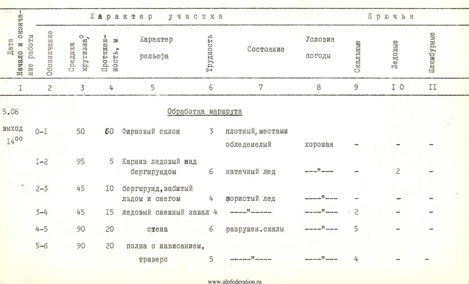
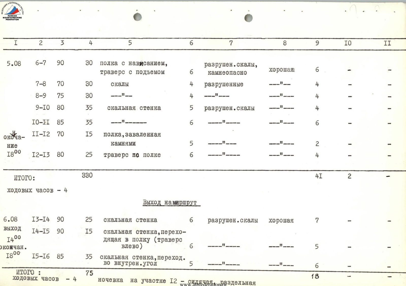
| Date Start and End of Work | Designation of Section | Average Steepness, ° | Length, m | Character of Relief | Diff. Cat. | Condition | Weather Conditions | Rock | Ice | Bolted |
|---|---|---|---|---|---|---|---|---|---|---|
| August 5 | Route processing | |||||||||
| departure 14:00 | R0–R1 | 50 | 60 | Firn slope | 3 | dense, местами обледенелый | good | – | – | – |
| R1–R2 | 95 | 5 | Ice cornice over bergschrund | 6 | натечный лёд | —"— | – | 2 | – | |
| R2–R3 | 45 | 10 | Bergschrund filled with ice and snow | 4 | пористый лёд | —"— | – | – | – | |
| R3–R4 | 45 | 15 | Ice-snow clutter | 4 | —"— | —"— | 2 | – | – | |
| R4–R5 | 90 | 20 | Wall | 6 | разрушен. скалы | —"— | 5 | – | – | |
| R5–R6 | 90 | 20 | Ledge with overhang, traverse | 5 | —"— | —"— | 4 | – | – | |
| August 5 | R6–R7 | 90 | 30 | Ledge with overhang, traverse with ascent | 6 | разрушен. скалы, камнеопасно | good | 6 | – | – |
| R7–R8 | 70 | 30 | Rocks | 4 | разрушенные | —"— | 4 | – | – | |
| R8–R9 | 75 | 30 | —"— | 4 | —"— | —"— | 4 | – | – | |
| R9–R10 | 80 | 35 | Rock wall | 5 | разрушен. скалы | —"— | 4 | – | – | |
| R10–R11 | 85 | 35 | —"— | 6 | —"— | —"— | 6 | – | – | |
| end 18:00 | R11–R12 | 70 | 15 | Ledge filled with stones | 5 | —"— | —"— | 2 | – | – |
| R12–R13 | 80 | 25 | Traverse along ledge | 6 | —"— | —"— | 4 | – | – | |
| Total: | 330 | 41 | 2 | – | ||||||
| working hours — 4 | ||||||||||
| Exit onto the route | ||||||||||
| August 6 | R13–R14 | 90 | 25 | Rock wall | 6 | разрушен. скалы | good | 7 | – | – |
| departure 14:00 | R14–R15 | 90 | 15 | Rock wall transitioning into a ledge (traverse left) | 6 | —"— | —"— | 5 | – | – |
| end 18:00 | R15–R16 | 85 | 35 | Rock wall transitioning into an internal angle | 5 | —"— | —"— | 6 | – | – |
| Total: | 75 | 18 | – | – | ||||||
| working hours — 4 | Overnight stay on section R12 — separate |

| Date Start and End of Work | Designation of Section | Average Steepness, ° | Length, m | Character of Relief | Diff. Cat. | Condition | Weather Conditions | Rock | Ice | Bolted |
|---|---|---|---|---|---|---|---|---|---|---|
| August 7 | R16–R17 | 90 | 5 | Rock wall | 6 | разрушен. скалы, скальные перья | good | 3 | – | – |
| departure 8:00 | R17–R18 | 90 | 10 | —"— | 6 | разрушен. скалы | —"— | 3 | – | – |
| R18–R19 | 85 | 25 | Internal angle | 6 | залит водой и обледенелый | —"— | 5/1 | – | – | |
| R19–R20 | 50 | 30 | Rock ridge | 4 | разрушен. скалы, covered with snow-ice cap | —"— | 3 | – | – | |
| R20–R21 | 80 | 10 | Rock wall | 4 | разрушен. скалы | —"— | 1 | – | – | |
| end 18:00 | R21–R22 | 50 | 20 | Rock ridge | 3 | плиты заглажен. | —"— | 4 | – | – |
| R22–R23 | 60 | 30 | —"— | 4 | —"— | —"— | 3 | – | – | |
| Total: | 130 | 21/1 | – | – | ||||||
| working hours — 10 | Overnight stay on section R16 — lying down |
... (rest of the table remains the same as in the original text)
Passage
The Eastern wall (right part) of Peak Kholodnaya Stena consists of 3 belts of rocks with an overall steepness of about 80° and a length of the rock section of about 2000 m.
The route is logical and diverse in forms of relief, includes:
- rock walls,
- cornices,
- snow-ice slopes when transitioning from the second belt of rocks to the third,
and does not allow deviation from the chosen ascent path. The route is complex throughout its entire length and requires climbers to master the entire arsenal of alpine techniques and have extensive experience in joint ascents of the highest difficulty category, prolonged in time for passing the route (corresponding psychological preparation is necessary).
Many sections are sheer or close to sheer, especially on the upper part of the lower belt of rocks "feathers", and on the middle belt of rocks "embryo" there are нависающие sections. Significant difficulties are created by the destroyed structure of the rocks, composed of quartz blocks with a small number of cracks, which complicates climbing and belay organization.
The route requires good physical and moral preparation and can be recommended to a strong group with excellent rock climbers. Throughout its entire length, the route keeps participants in constant nervous tension, which requires increased organization of safety during movement. Most of the route is protected by a system of cornices and is away from the main area of avalanche danger and rockfall (see photo).
The only rockfall-dangerous sections are the bergschrund zone during the initial ascent onto the rocks and snow-ice slopes when transitioning from one belt of rocks to another (from "feathers" to "embryo" and from "embryo" to the main belt). Considering the need for a large number of pitons, carabiners, and ladders, it is desirable to have lightweight equipment on the route.
Comparing the passed route with the routes previously passed by team members, who have extensive experience in ascending routes of 6B category, it can be confidently stated that it significantly surpasses previously passed routes (although they occupied 1st and 2nd places in the USSR Alpine Championships at the time) in the following parameters:
- steepness of individual sections and overall steepness of the entire route
- character of rock and snow-ice ridge structure
- number of sections with extremely complex climbing
- overall length
In accordance with the above, the route is undoubtedly a route of the highest complexity category. ![img-15.jpeg]({"width":134,"height":147