Ascent Passport
- High-altitude technical category.
- Yazgulem Range, Khavraz-Dara valley.
- Peak 5870 m via the north-eastern wall of the western spur.
- First ascent, category 5B difficulty (approximately).
- Route characteristics
Wall: length 1385 m. Length of sections with 5–6 category difficulty – 1155 m (6 category – 80 m, 5 category – 1075 m, 4 category – 230 m). Average steepness – 73° (steepness of sections with 5–6 category difficulty – 80°). Total route length 2225 m (6 category – 80 m, 5 category – 1075 m, 4 category – 500 m, 3 category – 470 m, 2 category – 100 m). 6. Pitons driven: for belaying, for creating artificial anchors (ITO) rock pitons – 104, including 10 for ITO ice pitons – 12, including 3 for ITO chocks – 8. 7. Total climbing hours – 52 (wall – 47). 8. Number of bivouacs – four (one on descent), including: lying – three, sitting – one. 9. Team leader – Honoured Master of Sports Viktor Aleksandrovich Solonnikov Team members: - Dmitry Igorevich Antonovskiy, Master of Sports - Vladislav Valentinovich Vedernikov, Master of Sports - Vilho Danilovich Pavilainen, Candidate for Master of Sports - Oleg Vasilievich Nazarov, Candidate for Master of Sports - Vladimir Lvovich Myasnikov, Candidate for Master of Sports - Mikhail Georgievich Bankovskiy, 1st sports category 10. Team coach – Viktor Aleksandrovich Solonnikov 11. Departure from base camp – July 10, return – July 15.
Team of LOS DSO "Trud"

Fig. 1. Map of the area. A – base camp.
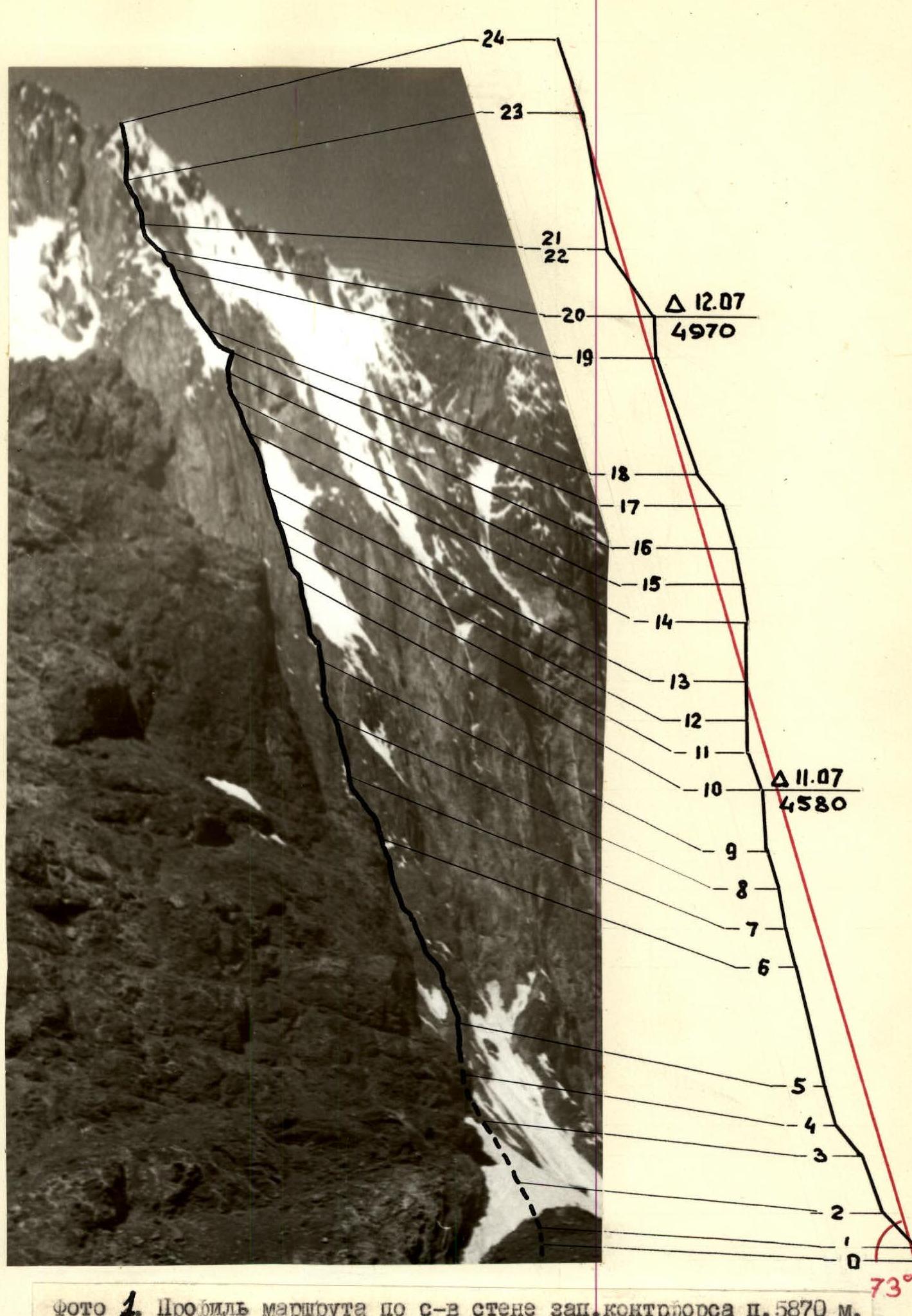
Photo 1. Profile of the route on the north-eastern wall of the western spur of Peak 5870 m.
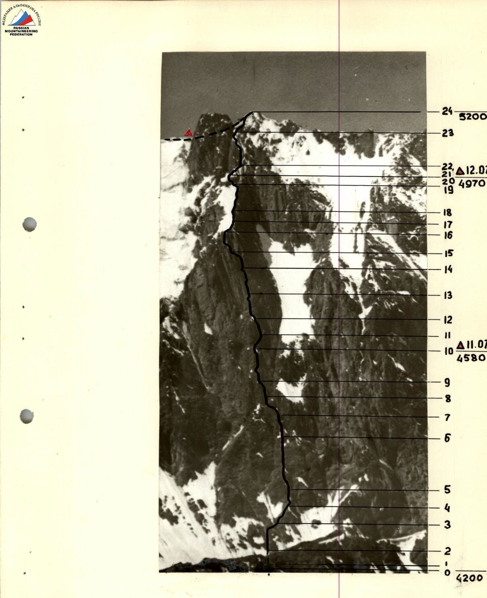
Photo 2. North-eastern wall of the western spur of Peak 5870 m.
I. Brief Geographical Description and Sporting Characteristics of the Route
Peak 5870 m is located in the Yazgulem Range between peaks 6047 m and 5539 m. The peak is separated from Peak 6047 m by a gap descending to an altitude of 5200 m. There are several rocky outcrops (gendarmerie) in the ridge connecting these peaks, rising to an altitude of 5500 m. A ridge-spur extends westward from Peak 5870 m, terminating in a north-eastern rock wall with several steep spurs. The spur descends westward to an altitude of 4900 m. Here is a relatively straightforward pass allowing transition from the Khavraz-Dara valley to the Grum-Grжимайло glacier via short lateral glaciers. The north-eastern wall of the western spur of Peak 5870 m has a height difference of about 1000 m and a steepness of about 70°. Paths on this wall follow steep wall-spurs, and there can be several such paths. All are category 5B difficulty. The path chosen by the team is the leftmost on the wall; it is very logical, safe, and sufficiently challenging. This is a combined route. The most complex part is the rock wall. The wall is steep, covered with ice in many places, and composed of very soft rock. The approach to the wall and the upper rock tower is snow-ice, with sections of steep ice and loose snow on an ice base. After reaching the spur ridge, the further path to the summit along the western ridge is a combined route of 3–4 category difficulty.
II. Brief Description of Climbing Conditions in the Khavraz-Dara Valley
The approach to the route from the lower village of Pasor (at the mouth of the Khavraz-Dara river) along a trail 30–35 km to Lake Khavraz-Dara and then left along the moraine and glacier to the wall – 1.5 hours. The glacier elevation under the wall is 4200 m. The ridge elevation of the spur is 5200 m. The rocks forming the routes in the area are soft. There are many loose rocks on the routes. Increased rockfall danger. Significant glaciation of routes, especially those with northern and western aspects. The weather in the area is unstable. Weather cycles of 3–4 days with heavy snowfalls are characteristic.
III. Reconnaissance
The routes on the wall of the western spur were observed by the team during acclimatization-training climbs on July 4–5 and July 7–8. The route was studied from the Soblaaznitelny pass using a telescope with 60x magnification. The ascent path was identified, and it was determined that the main, wall part of the route is not prone to rockfall. The lower part may be subject to rockfall in the middle of the day.
IV. Tactical Plan for the Ascent
The tactical plan (see route sheet) involves preliminary processing (sections R0–R5) of the lower part of the route so that on the following day, it is possible to quickly pass the more rockfall-prone part of the route in the morning. Further, two bivouacs on the wall were planned – one in the centre, before the steep central ascent (key section), and the second on the ice ridge before the upper tower. On the third day, it was planned to reach the ridge and on the following day – the summit. Descent was planned along the ascent path to the beginning of the rock spur and then, bypassing it on the left along the glacier, through the pass – return to the Khavraz-Dara valley. It was planned that the first climber would work without a backpack. Equipment and supplies would be minimal in weight (see Appendix M), allowing no need to pull up backpacks anywhere. Particular attention should be paid to the tactical choice of path to minimize the likelihood of rockfall. On the route, it is planned to use chocks, soft ladders, tubular ice screws, special ice bailails, and other new types of equipment. The planned ascent plan was fully implemented.
V. Composition of the Assault Team
Assault team: leader – Honoured Master of Sports V.A. Solonnikov, members: Master of Sports D.I. Antonovskiy, Master of Sports V.V. Vedernikov, Candidate for Master of Sports V.D. Pavilainen, Candidate for Master of Sports O.V. Nazarov, 1st sports category M.G. Bankovskiy. The team maintained regular radio communication with the base camp and the observation group (see observation and radio communication diary), as well as radio communication with the group of B.P. Vasiliev, who was climbing simultaneously with the team on a parallel, more right-hand spur.
VI. Order of Passage of the Route (Brief Explanation to the Table of Main Characteristics)
July 10. The team in full departed from the base camp and approached the route. The route is in shadow, and rockfall danger is minimal. Bankovskiy, Nazarov, and Vedernikov went out to process the route. The passage of the bergschrund was quite complex, with a 10 m ice wall encountered (section R0–R1). Above the wall, there is overhanging snow. The wall is passed in crampons, using ladders and an ice screw. Further, there is an ice slope and a rock wall with two steep (15 m each) ascents and many loose rocks. Then, again, an ice slope and a couloir. The couloir is crossed from left to right. A steep rock spur ascends and rises to the right and left of it. The wall of the spur is 40 m. Under the overhang, the last rope is secured, and by 20:00, the processing is completed. Bivouac on the moraine under the route.
July 11. Departure at dawn, at 5:30. By 7:00, the processed sections are passed, and movement on the rocks of the steep, heavily destroyed spur begins (120 m). Under a corniche, a rope is secured, and using a pendulum, a transition is made through the left gully-couloir to the main wall of the spur. Along smoothed rocks, an approach is made under an overhanging ledge (section R6–R7). To bypass the ledge, an ascent is made using an internal corner 40 m to a steep, wet, and icy slab. Along it, the wall is bypassed on the right, and 60 m upwards along a sheer face. Small cornices are encountered. Climbing is complex and tense (section R9–R10). After this section, there is a rock-ice ridge where a sitting bivouac is constructed, and the beginning of the main bastion is processed. 40 m along steep, wet, smoothed slabs to the base of an internal corner leading to the left face of the wall. Along the corner, 30 m of complex climbing. Then, a traverse to the right is needed to another internal corner and onto the central wall, but the rocks are very destroyed, and rocks will fall directly onto the bivouac site. Processing is completed, and by 20:30, everyone is down for a bivouac. Half of the route by distance is passed, and a significant part of the central wall – a total of 570 m: 200 m processed the previous day, 300 m to the bivouac, and another 70 m processed. All newly passed sections are category 5 difficulty. Nazarov and Vedernikov worked at the front.
July 12. Departure at 7:30. Everyone gathers at the end of section R11–R12. Thus, it is possible to work further – rocks will fall to the side. Ahead is a sheer internal corner – 40 m and a smooth sheer wall 60 m – this is the key section of the route. The relief has small holds, and there are two slots on the wall. The transition from the first to the second slot is very complex. Some pitons are used as handholds, and pendulum movements are applied. Chocks are used in the slots. Above, the internal corner is closed by a corniche – a pendulum to the left onto an external corner, and upwards-left (section R14–R15). Traverse along a slab and ascent 40 m along a smoothed internal corner. Another 40 m along ice-covered rocks and further along loose snow on an ice base – exit onto a ridge ending the central part of the wall. Further movement along the ridge to the right, along the boundary of rocks and ice, 120 m, and again exit onto the ridge along a sheer internal corner with overhanging ice (section R19–R20). Here, on snow on the ridge, is a lying bivouac. Above the bivouac, another 80 m is passed along a snow-ice ridge, and ropes are hung (belaying through pitons driven into rock outcrops). For the day, 500 m is passed, including 70 m processed the previous day, another 220 m of wall, and 280 m of ridge between the central wall and the upper tower. Ice sections are passed in crampons, 4 ice screws are driven, but mainly belaying is through rock pitons.
July 13. Departure at 6:30. Overcast, snow, and sleet. After passing the processed ropes, a descent (rappel) into a gap (15 m) and ascent along the wall of the upper tower. During the descent, a self-releasing ice axe is used. The wall is 120 m, steep, and very destroyed. Climbing is very tense, and organizing reliable belaying is complex. The bastion ends with a snow-ice ridge with a rock tower. During the passage of the section, ice screws and ladders are used. Further along simple rocks and along the western ridge – exit onto a scree saddle – 17:00. Here is a bivouac. For the day, 395 m is passed along the wall, including 80 m of ridge processed the previous day.
July 14. Snow fell 50 cm in the morning. Visibility is limited. Departure at 10:00. At 15:00, having passed 300 m along a snow-ice-rock ridge, the team reached the summit of Peak 5870 m. A cairn is complex, and a note about the first ascent is left. The ridge is 3–4 category difficulty, and movement is significantly hindered by fresh snow. Descent to the saddle took 2 hours. The next day, descending to the glacier under Peak 6047 m via a pass between the western rib of Peak 5870 m and Peak 5539 m, the team returned to the base camp.
Evaluation of the Team Members' Actions
Team members on the route demonstrated good and versatile preparation. The team moved along the route without delays – they managed to gather when the first climber worked, and thus moved at the pace of a duo.
Team leader – V.A. Solonnikov
Additional Data on the Route
The route taken by the team is logical and technically complex. This ascent is category 5B difficulty. The main complexity is the rock part of the route, but there are also snow-ice sections requiring the use of ice climbing techniques. The wall has a significant length (over 1000 m). An additional complexity characteristic of the entire area is the non-solid rock, which adds difficulties both during movement and when organizing belaying and group movement. When comparing this route with classic category 5B routes such as Dikh-Tau, Mizhirgi, Peak Moskovskoy Pravdy (Shabanov's path), and several others, it is noted that the path to Peak 5870 m has greater technical complexity and is more challenging organizationally.
The team decided to name the climbed peak after the well-known Leningrad mountaineer and rock climber, a constant member of the team until 1978 – Yuri Semenovich Manoilov.
Team Leader and Coach
V.A. Solonnikov
Team Members:
- D.I. Antonovskiy
- V.V. Vedernikov
- V.D. Pavilainen
- O.V. Nazarov
- M.G. Bankovskiy
- V.L. Myasnikov
Table of Main Characteristics of the Ascent Route to Peak 5870 m via the North-Eastern Wall
Route length – 2125 m (without scree when approaching the saddle) Length of most complex sections – 1155 m. Average steepness of the route (wall) – 73° Average steepness of the most complex sections – 80°
| Date | Section Number | Section Length | Average Steepness, degrees | Relief Character | Difficulty | Condition | Weather Conditions | Rock Pitons | Ice Pitons | Chocks |
|---|---|---|---|---|---|---|---|---|---|---|
| Processing | ||||||||||
| 10.07 | R0–R1 | 10 m | 90 | ice wall | 5 | edge of bergschrund, water flowing | clear | 1 (1) | – | – |
| R1–R2 | 50 m | 45 | ice slope | 4 | ice with rocks | 1 | – | – | ||
| R2–R3 | 60 m | 70 | rock wall | 5 | destroyed rocks | 3 | – | – | ||
| R3–R4 | 40 m | 50 | ice slope, couloir | 4 | 2 | 1 | – | |||
| R4–R5 | 40 m | 70 | rock wall | 4 | destroyed rocks | 3 | – | – | ||
| Departure at 16:30, return at 20:00. Climbing hours 3 h 30 min. 8 rock and 3 ice pitons driven, 200 m passed. Bivouac on moraine under the route. | ||||||||||
| 11.07 | R5–R6 | 120 m | 75–80 | rock spur | 5 | destroyed, heavily ice-covered rocks | clear | 10 | – | – |
| R6–R7 | 40 m | 75 | rock-ice gully and wall | 5 | smoothed rocks | 4 | – | – | ||
| R7–R8 | 40 m | 80 | wall, internal corner | 5 | wet, destroyed, partly overhanging rocks | 4 | – | – | ||
| R8–R9 | 40 m | 70 | slab | 5 | smoothed, ice-covered slab | 3 | – | – | ||
| R9–R10 | 60 m | 85 | wall | 5 | sheer smoothed wall | 6 | – | – | ||
| Processing | ||||||||||
| R10–R11 | 40 m | 70 | Slabs | 5 | smoothed, wet rocks | 3 | – | – | ||
| R11–R12 | 30 m | 90 | internal corner | 5 | destroyed wet rocks | 4 | – | – | ||
| Departure at 5 h 30 min, end of work at 20 h 30 min. Climbing hours 15 h 00 min. 34 rock pitons driven, 200 m processed the previous day and another 370 m passed. Bivouac at the end of section R9–R10, sitting. | ||||||||||
| 12.07 | R12–R13 | 40 m | 90 | internal corner, wall | 5 | smoothed rocks with small holds | clear | 6 (2) | – | 1 time – chock |
| R13–R14 | 60 m | 90 | wall | 6 | very complex smoothed wall, slots | 8 (4) | – | 3 times – chocks | ||
| R14–R15 | 40 m | 80 | internal corner – external corner | 5 | wet destroyed rocks | 4 (1) | – | – | ||
| R15–R16 | 40 m | 80 | internal corner, slab | 5 | traverse along slabs, wet corner | 4 | – | 2 times – chocks | ||
| R16–R17 | 40 m | 70 | rocks with ice | 5 | exit to snow-ice section | 3 | – | – | ||
| R17–R18 | 40 m | 50 | snow with ice | 4 | loose snow on ice base | 2 | – | – | ||
| R18–R19 | 120 m | 70 | rocks with ice | 4–5 | traverse along ice ridge of spur along rock outcrops | 8 | – | – | ||
| R19–R20 | 40 m | 85 | slabs, internal corner | 5–6 | smoothed, ice-covered corner, overhanging ice | 4 (1) | 1 | – | ||
| Processing | ||||||||||
| R20–R21 | 80 m | 50–60 | snow-ice ridge | 4–5 | loose snow with ice | 3 | 1 | – | ||
| Departure at 7:30, end at 20:00. Climbing hours 12 h 30 min. 40 rock and 4 ice pitons driven, 6 times chocks used. Bivouac on snow, lying, at the end of section R19–R20. 500 m passed. | ||||||||||
| 13.07 | R21–R22 | 15 m | 80 | wall, descent to saddle | snowing | – | – | – | ||
| R22–R23 | 120 m | 80 | rock wall | 5 | destroyed, ice-covered rocks | 11 (1) | – | 2 times – chocks | ||
| R23–R24 | 80 m | 70 | snow-ice ridge with rock tower | 5 | wet snow. Bypass of tower and seracs, exit to top of wall | 3 (1) | 3 (1) | – | ||
| R24–R25 | 100 m | – | scree, rock ridge | 2 | exit to saddle | – | – | – | ||
| Departure at 6:30, stop at 17:00. Climbing hours 10 h 30 min. 80 m of ridge processed the previous day and another 315 m passed along the wall. 14 rock and 3 ice pitons driven, 2 times chocks used. Bivouac lying on scree. | ||||||||||
| 14.07 | R25–R26 | 700 m | 50 | snow-ice-rock ridge | 3–4 | fresh loose snow on rocks and ice. On slopes – avalanche danger. Snow in layers slides off rock slabs and ice sections | blizzard, strong wind, snow. 50 cm of snow fell overnight | 8 | 2 (1) | – |
| Departure at 10:00, at 15:00 on the summit, and at 17:00 descent to the saddle. Climbing hours to the summit 5 h 00 min. 8 rock and 2 ice pitons driven. | ||||||||||
| Total climbing hours for the ascent 52 h 00 min (wall 47 h 00 min). 104 rock (for ITO–10) and 12 ice (for ITO–3) pitons driven, 8 times chocks used. | ||||||||||
| On the route: category 6 – 80 m, category 5 – 1075 m, category 4 – 500 m, category 3 – 470 m, category 2 – 100 m. | ||||||||||
| Team Leader | V.A. Solonnikov |