ASCENT DOCUMENT
- Category of ascent — high-altitude technical (traverse).
- Area of ascent — South-West Pamir, Shakhdarin Range.
- Traverse of peaks: “5800”–p. “Soviet Army”–p. “Baikonur”–p. “Marshal Grechko”.
- Characteristics of the ascent:
- height difference — 1200 m.
- average steepness — 65°
- length of difficult sections — 1140 m – 5B cat. diff. 880 m – 4 cat. diff. 1630 m – 3 cat. diff. 960 m – 2 cat. diff.
- Pitons used:
- rock pitons — 107 pcs.
- ice screws — 22 pcs.
- bolt pitons —
- Time taken to reach p. “Marshal Grechko” — 36.5 hours.
- Number of nights spent — three:
- first in a tent on the rocky ridge of p. “5800”;
- second in a tent on the saddle between p. “Soviet Army” and p. “Baikonur”;
- third in a tent on the pre-summit ridge of p. “Baikonur”.
- Team from Novosibirsk Regional Sports Committee:
- leader KOPYTIN NIKOLAI DMITRIEVICH — Candidate Master of Sports
- participant GALIN VLADIMIR — 1st sports category
- participant PASHKOV PETR MIKHAILOVICH — 1st sports category
- participant SOLOBOEV VLADIMIR — Candidate Master of Sports
- participant FILATOV SERGEI ALEKSEEVICH — Candidate Master of Sports
- participant YUN VITALY MIKHAILOVICH — 1st sports category
COACH Kurgin Sergei Nikolaevich — Master of Sports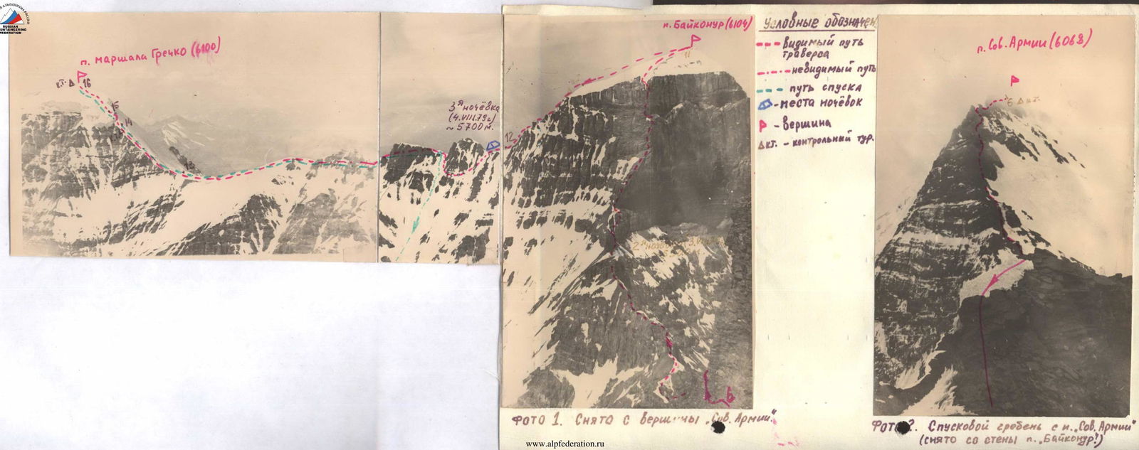
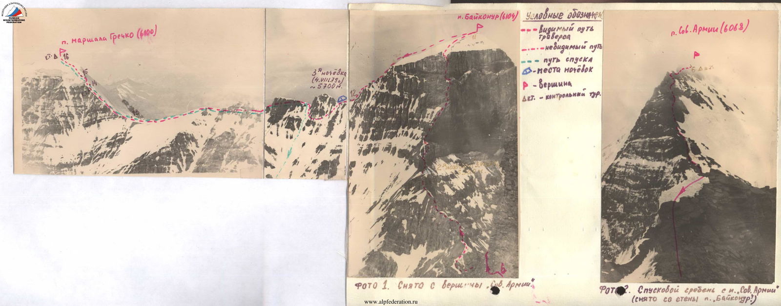 TABLE of main route characteristics
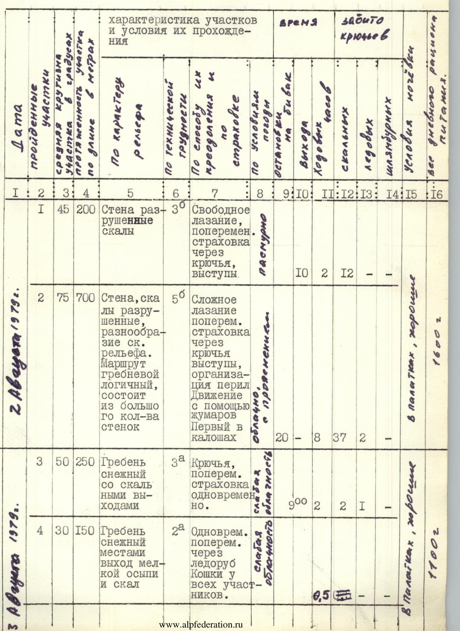
| № | Date | Avg. steepness | Section length | Characteristics of sections and conditions of passage | Cat. diff. | Weather | Time (ascent) | Time (rest) | Climbing hours | Rock pitons | Ice screws | Bolt pitons | Nights | Notes | Daily food ration weight |
|---|---|---|---|---|---|---|---|---|---|---|---|---|---|---|---|
| 1 | August 2, 1979 | 45° | 200 m | Wall, broken rocks. Free climbing, alternating belay through pitons, ledges. | 3 | overcast | 10 | 2 | 12 | — | |||||
| 2 | August 2, 1979 | 75° | 700 m | Wall, rocks broken, diverse rock relief. Ridge route logical, consists of many small walls. Difficult climbing, alternating, belay through pitons, ledges, organization of rope barriers. Movement with Jumars. First in galoshes. | 5 | cloudy, clearing | 20 | 8 | 37 | 2 | Good in tents | 1600 g. | |||
| 3 | August 3, 1979 | 50° | 250 m | Ridge snowy with rock outcrops. Pitons, alternating belay simultaneously. | 3 | light cloud cover | 9:00 | 2 | 2 | 1 | Good in tents | 1100 g. | |||
| 4 | August 3, 1979 | 30° | 150 m | Ridge snowy, sometimes with small scree and rocks. Simultaneous, alternating through ice axe. Crampons on all participants. | 2 | light cloud cover | 0.5 | — | — | — | |||||
| 5 | August 3, 1979 | 40° | 300 m | Slope snow-ice. Alternating through ice axe. Crampons. | 2 | clear | 1 | ||||||||
| 6 | August 3, 1979 | ±50° | 2000 m | Snow field. Simultaneous in crampons. | clear | 2 | |||||||||
| 7 | August 3, 1979 | ±55° | 800 m | Ridge, gendarmes, snow, rocks very broken. Alternating. Sport descent, pitons, ledges, ice axe. | 4 | clear | 3.5 | 8 | |||||||
| 8 | August 3, 1979 | ±15° | 300 m | Ridge gentle with gendarmes, snow. Alternating through ledges. | 3 | overcast | 18:00 | 1 | — | — | — | ||||
| 9 | August 3, 1979 | 60° | 80 m | Ridge, rocks in walls up to 20 m. Rope barriers, piton belay. Movement with Jumars. | 4 | cloudy | 9:30 | 0.5 | 6 | ||||||
| 10 | August 3, 1979 | 80° | 400 m | Wall, cornices, inner corner, sections with overhangs. In middle and end of section artificial holds (ladders). Rope barriers, movement with Jumars. Pulling up rucksacks. | 5 | low cloud cover | 9 | 48 | 2 | ||||||
| 11 | August 3, 1979 | 50° | 180 m | Ice firn. Alternating, belay through ice axe, crampons. | 3 | cold | 0.5 | — | 3 | — | |||||
| 12 | August 3, 1979 | –30° | 300 m | Snow ridge, then broken rocky. Crampons. Alternating through ice axe and simultaneous. | 3 | windy | 20:30 | 1 | 2 | — | — | Good in tents | 1300 g. | ||
| 13 | August 5, 1979 | –30° +30° | 600 m | Ridge snowy, snow cornices. Rocky “gendarmes”. Simultaneous bypass of “gendarmes” with alternating belay through ice axe. | 2 | wind, cold | 7:30 | 1.5 | — | — | — | ||||
| 14 | August 5, 1979 | 45° | 200 m | Ridge firn, ice exposure, rock outcrops. Alternating through ice axe, step cutting, crampons. | 3 | cloudy | 1.5 | — | 8 | ||||||
| 15 | August 5, 1979 | 75° | 30 m | Ice wall. Step cutting, ice axe pitons. | 5 | cloudy | 2 | — | 6 | — | |||||
| 16 | August 5, 1979 | 40° | 200 m | Ridge firn, flattening towards top. Alternating through ice axe, crampons. | 3 | cloudy | 1.5 | — | — | — | Good in tents | 1200 g. | |||
| Descent by ascent route to section 12 and further down snow to glacier. | 18:00 | 3.5 | — | — | — | Ice column cut for descent on section 15 |
GEOGRAPHICAL DESCRIPTION OF THE AREA
The peaks of the traverse are located in the South-West Pamir in the Shakhdarin Range at the source of the Tugrifon River, which flows into the Pyandzh River near the village of Shitkhargv.
The traverse area can be accessed from the north by passing two passes. Approaches from the south are long, complicated by the fact that the trail to the 1st base camp (see map) partly goes along the river in a narrow canyon, sometimes destroyed and hardly suitable for a caravan of donkeys. From the 1st base camp to the 2nd, there is practically no trail, the approach is along the riverbed. From the village of Shitkhargv to camp 1 at the second confluence — 6–7 hours of walking and to camp 2 on the left (orographic) coastal moraine of the glacier opposite the eastern wall of p. 5739 m — another 8–10 hours.
1st day of journey, August 2, 1979
From base camp 2, we set out at 6:00 AM, crossed the glacier in the direction of the saddle between p. “Baikonur” and p. “Soviet Army”, and climbed to the saddle in 1.5 hours. We left a cache on the saddle: part of the supplies, pitons, spare rope, and gasoline. The descent from the saddle to the opposite side was difficult through rocky outcrops and snow, with piton belay, taking 40 minutes, then moving down the glacier along the eastern walls of p. “Soviet Army” to the start of the route. To the right of the route from the summit “5800”, a broken glacier descends.
We started moving along the route at 10:00 on August 2, 1979. The ascent up the eastern counterfort of p. “5800” is quite logical. The first section — 200 m of broken rocks — is overcome by a series of small walls with alternating piton belay. Further, the route becomes significantly more complicated. The relief is diverse. Movement is complicated by the fact that the rocks are broken, requiring increased attention. Almost the entire section to the flattening of the ridge is traversed on a double rope. The steepness of individual sections reaches up to 85°.
Belay is through pitons:
- 37 rock pitons;
- two ice screws in rocks for reliable belay.
The first climbers take turns: Kopytin, Filatov, Soloboev. We reached the flattening part of the ridge and set up camp at 20:00. We pitched tents in a wind-protected area.
The part of the route covered corresponds to 5B cat. diff. All participants climbed in Vibram shoes, the first (Filatov) wore galoshes when overcoming the inner corner and slabs in the middle part of the wall.
2nd day of journey, August 3, 1979
The night passed well. We set out on the route at 9:00. The path to the summit “5800” went along a snowy ridge with rock outcrops, steepness up to 50°. The snow is dense, crampons were used, in some places ice was exposed. These sections were overcome with alternating belay through an ice axe, one ice screw was driven, and two rock pitons in rock outcrops.
We reached the summit at 11:00, having covered about 250 m. On the summit, on the nearest rock outcrops, a control cairn was built. The summit dome is snow-covered. The descent to the saddle towards p. “Soviet Army” is simple, along a snowy ridge, sometimes with scree. The ascent to p. “Soviet Army” is up a steep firn slope. To the left, there are huge ice drops and cornices. To the right, there are snowy cornices. The path down from the summit “5800” and further was traversed in crampons with alternating belay through ice axes. The summit of “Soviet Army” represents huge snowy fields, dropping off to the right with cornices and walls – to the left descends a glacier. The control cairn was not found. We built our own on the most protruding part of the rocks to the left, a hundred meters from the beginning of the descending ridge towards p. “Baikonur”. The descent towards p. “Baikonur” is along a broken rocky ridge. While moving, part of the “gendarmes” is bypassed to the right and left through the snow. In four places, sport descents were organized with rope pulling. Many flat areas are suitable for camping. On the flattening part of the ridge, a control cairn of previous climbers was found, and traces of their stay: a cordelette, a gasoline canister.
We stopped for the night near our cache at 18:00. The site is convenient and flat. We rested well. In the remaining daylight, the Kopytin–Pashkov rope team processed the beginning of the further path — hung 80 m of rope barriers.
The route covered during the day is not technically difficult but is very long, passed at an altitude of about 6000 m, and required a lot of physical effort. The descent from the summit “Soviet Army” requires increased caution due to the abundance of loose stones and their spontaneous falling due to snow melting.
Movement sometimes passed through more complex but safe sections.
3rd day of journey, August 4, 1979
We started moving along the rope barriers hung the previous day at 5:30. Since it was quite cold. The area to the right — sheer black walls. We moved to the left along the ridge, passed three ropes of difficult climbing — slabs, walls. We approached a 200-meter wall. Movement is straight up. Exceptionally difficult climbing, overhanging sections are passed using ladders. Rope pulling is organized with a backstay. Sections are traversed with the help of Jumars on rope barriers. Exit to a wide shelf, the edges of which are fired upon by small stones. Under a rocky cornice, the whole group gathers in a safe place. We built a control cairn. To the right, there are overhanging walls. Traverse to the left along an inclined shelf and ascent upwards along an inner corner turning into a wall. 100 m of exceptionally difficult climbing with pulling up rucksacks and movement along rope barriers on Jumars leads to a wide snowy ridge going to the summit. To the right, snowy cornices overhang. Movement in crampons to the summit. Strong wind, cold, 18:00. We decided to descend to the saddle of p. “Marshal Grechko”.
A long snowy slope turns into a rocky ridge, the encountered “gendarmes” are strongly broken. On the nearest rock outcrops to the summit — a control cairn of previous climbers. Almost all “gendarmes” are bypassed to the right along snowy “commas”.
During the day, we used:
- 52 rock pitons;
- 1 ice screw.
We stopped for the night on a snowy saddle at 20:30.
4th day of journey, August 5, 1979
We set out at 7:30. The first large “gendarm” was bypassed to the left along the snow. The snow is dense, crampons were used as steps. Movement is simultaneous. Having climbed to the ridge, we left part of the gear and equipment, as we plan to descend to the glacier from here. To the right of this “gendarm”, there are large snowy cornices. The further path along the ridge is not difficult. Movement is in rope teams, simultaneous. To the right, two more “gendarmes” are bypassed through the snow and further along the snowy ridge to the beginning of the ascent to p. “Marshal Grechko”. At first, about 200 m up a steep firn ridge with alternating belay through an ice axe and in crampons. We approached an ice cornice. Overcame it with belay through ice axe pitons and step cutting. Hung rope barriers. Further, a steep snowy slope, flattening towards the highest point. Movement with belay through an ice axe. In the summit area, there are no rock outcrops. The control cairn was discovered on the return journey near the first rock outcrops. We were on the summit at 14:10.
DESCENT AND RETURN TO BASE CAMP
Descent by ascent route. For descent from the ice cornice, an ice column was cut. The last one descended on a double rope with rope pulling. We approached the left gear and began descending down a snowy couloir towards the glacier to base camp. The descent was quick. The snow is dense, crampons were used. In the steepest part — movement with alternating belay through an ice axe. Having descended to the glacier, we crossed it and in 30 minutes were with the observers in base camp 2.
CONCLUSION
The traverse route is diverse in relief (rocks, ice, firn). Abounds with difficult sections, great length, and significant altitude above sea level; the route undoubtedly deserves an assessment of 5B cat. diff. Moreover, the ascent to p. “5800” and p. “Baikonur” can be distinguished as independent routes of 5B cat. diff.
The area of the traverse peaks is interesting from an alpinist's point of view. On nearby peaks, first ascents of various difficulty categories are possible. However, the participation of climbers in the development of this area is complicated due to long approaches, lack of good trails suitable for pack animals.
RECOMMENDATIONS FOR CLIMBERS
For a group of 6 people, the following equipment is required:
- first-aid kit — 2 pcs.
- tents — 2 pcs.
- stove — 2 pcs.
- radios — 1 pc.
- rock pitons — 30 pcs.
- ice screws — 10 pcs.
- three-step ladders — 2 pcs.
- crampons — 6 pcs.
- hammers — 3 pcs.
- food supply for 6 days
- main rope — 4×40 m, 1×80 m
- Jumars — two per participant
- personal gear
During the traverse, there are many convenient sites for camping, but water has to be obtained from snow. When traversing the route, it is necessary to consider the rockfall danger of rocky sections and the requirement for good acclimatization. Possible cache locations: saddles between p. “Baikonur” and p. “Soviet Army”, between p. “Baikonur” and p. “Marshal Grechko”.