PASSPORT
I. High-altitude class 2. South-West Pamir 3. Peak Engels 6510 m via the Center of the eastern wall 4. Difficulty category — 6 5. Elevation gain: 1410 m, wall length 900 m, length of sections with 5–6 difficulty category — 530 m, average steepness of the wall — 70°. 6. Pitons hammered:
| rock | bolt | chocks | ice |
|---|---|---|---|
| 90/18 | 1/8 | 82/21 | 18 |
- Climbing hours to the summit — 44; 5 days
- Night bivouacs: 1, 2, 4 — lying, 3 — sitting
- Captain: Kolobaev Sergey Petrovich — Candidate Master of Sports
Team members:
- Boyko Valeriy Viktorovich — Master of Sports
- Efimov Viktor Borisovich — Master of Sports
- Martynov Leonid Borisovich — Candidate Master of Sports
- Coach: Penchuk Valentin Lavrentyevich — Master of Sports
II. Approach to the route: July 29, 1984
Summit — August 2, 1984
Descent — August 3, 1984
Profile of the wall from the left. Photo point #2 from the slopes of Peak Moskovskoy Pravdy. h = 4700 m, Amateur camera, F = 60 mm.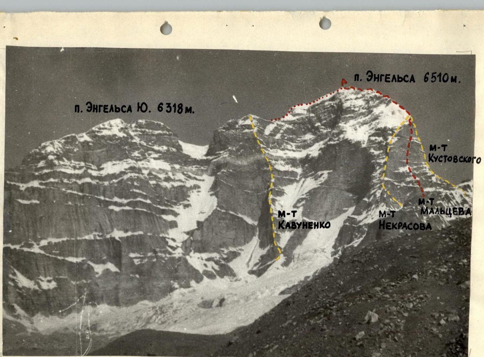
Photopanorama of the Engels massif. Photo point #3. Amateur camera — F = 6 cm.
TACTICAL ACTIONS OF THE TEAM
The core of our team was formed in 1978 when Boyko and Efimov first participated in the championship of the Central Sports Council of the Zenit Sports Society. Later, they, along with Kolobaev, repeatedly participated in various championships, including the USSR championships. We had climbed the walls of Ushba, Chatyn, Mizhirgi, Zindon, Chapdara, Guamysh, Bodkhona, and Oshanin. The tactics for ascending the Eastern wall of Peak Engels largely coincided with our previous ascents. We also used a double rope when the first climber moved and for all others on challenging terrain, with the first climber carrying a lightened backpack. The second climber also had a hammer, allowing us to correct and straighten the path.
However, there were some peculiarities. The rope teams were of fixed composition: Martynov-Boyko and Efimov-Kolobaev. This allowed us to navigate simpler sections independently (sections R1–R3, R11–R22, R28, R32), which accelerated our progress on the route.
After reaching the third bivouac, when Efimov and Kolobaev were cutting out a platform in the ice, Martynov and Boyko processed a ledge, the exit from it to the wall, and the beginning of the wall (sections R28–R29).
A notable aspect of this ascent was that we were the first group to tackle this route that year. Much effort and time were spent organizing bivouacs and restoring the bolted route. We began our ascent after bad weather, which complicated the group's movement on the first day until the sun cleared the rocks of snow.
The team fully executed the tactical plan, allowing us to descend to the base camp on August 3, 1984. Radio communication was maintained via the "Vitalka" radio station four times a day.
The proximity of Osokin's team (Nekrasov route) and Kogan's team (Kustovsky route) gave the participants a sense of camaraderie and a positive attitude for the task.
DESCRIPTION OF THE ROUTE BY SECTIONS
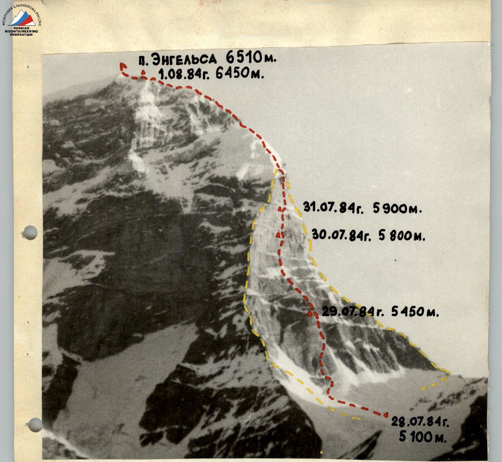
July 29, 1984
- R1: 300 m, 40°. From the hollow below the bastion up a snowy slope.
- R2: 5 m, 90°. Ascend to the bottom of the bastion. The bergschrund is crossed at its narrowest point near the lower end of the rock island. The first challenging spot. Then upwards.
- R3: 20 m, 40°. Bypassing the rock island on the right under the bastion's rocks. Here, the first climber, Martynov, puts on galoshes.
- R4: 40 m, 70°. The route begins on the left side of the internal corner up to a cornice (photo 1). The rock is heavily deteriorated. After recent bad weather, the sun melts the fresh snow and.
- R5: 5 m, 130°. The rocks are wet. The cornice is traversed on its right part using artificial aids. It is clearly visible in photo 2.
- R6: 10 m, 70°. Above it, the internal corner meets a smooth wall.
- R7: 30 m, 70°. With cornices. We decide to traverse to the right. A challenging traverse using a "Sky-hook," small holds, very difficult climbing (photo 2). Then it's easier, up.
- R8: 60 m, 75°. Yellow rocks to the 1st control cairn. From it upwards.
- R9: 20 m, 80°. To the left leads an internal corner (wet rocks, snow in niches).
- R10: 25 m, 90°. Transitions into a chimney filled with ice. From above.
- R11: 5 m, 110°. The chimney is closed by a cornice. Extremely challenging climbing on icy and wet rocks (Photo 2A).
- R12: 20 m, 50°. On the cornice hang icicles. At the top of the cornice is a ledge, from which a traverse to the left for 20 m to a comfortable overnight stay. In total, 11 hours of work for the day. Clearing the site took another 2 hours.
July 30, 1984
- R13: 20 m, 50°.
- R14: 10 m, 60°.
- R15: 20 m, 60°.
- R16: 40 m, 45°.
- R17: 20 m, 70°.
- R18: 100 m, 45°.
- R19: 10 m, 70°.
- R20: 60 m, 50°.
- R21: 40 m, 75°.
- R22: 20 m, 50°.
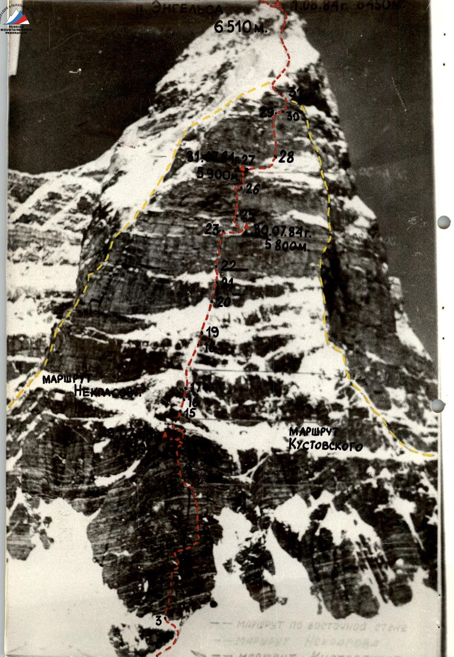
We traverse along the ledge to the wall intersected by a chimney. The chimney is filled with ice. Above it is a rocky wall with a crack, a small snowy ledge. Then we reach a steep, smooth wall. Very challenging climbing. After it, the team reached a ridge connecting the bastion to the main wall. On the ridge, snow alternates with steep walls. Overcoming the second rocky wall with an overhanging top required the use of ladders.
- R23: 70 m, 80°.
- R24: 30 m, 30°.
A snowy-icy ridge led us to a grey granite wall with cornices. In the upper part, the wall becomes steeper. Very challenging. The cornices are passed using artificial aids (photo 3). Above is a wide ledge abutting a loose wall. A traditional bivouac spot. Also, a 2nd category difficulty cairn. For the day.
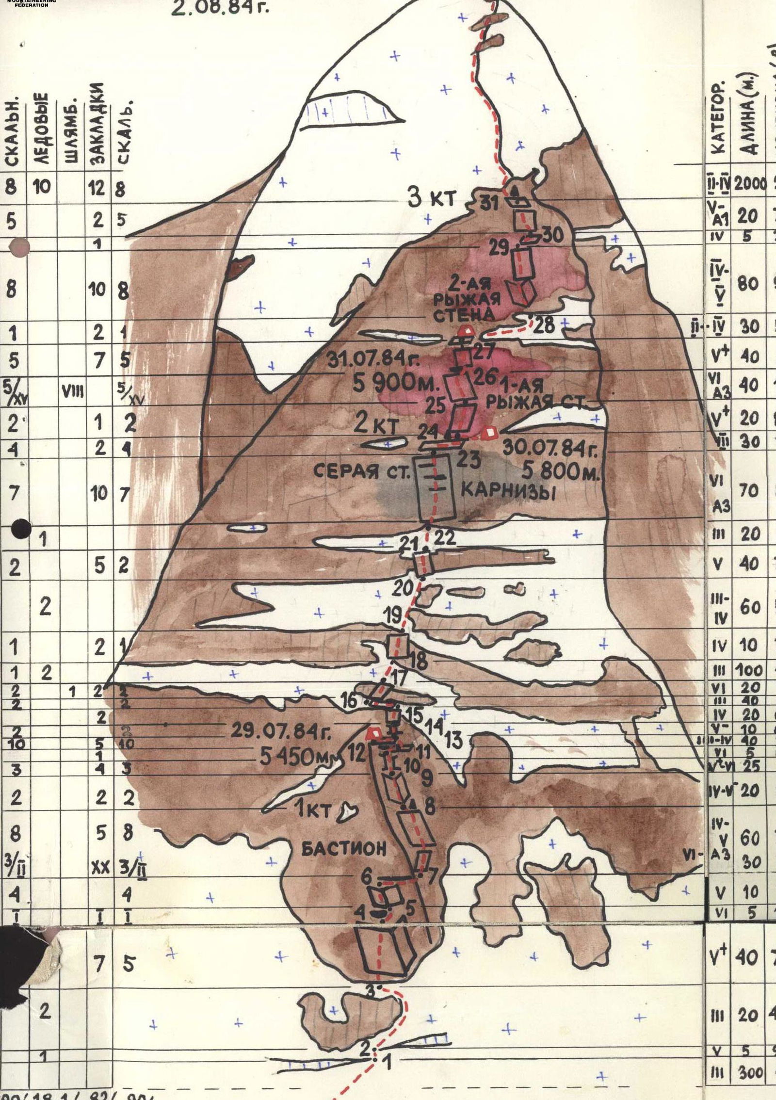
July 31, 1984
- R25: 20 m, 80°. In the morning, we started working on the first red wall. The bottom part is passed relatively easily. Steepness ≈ 80°.
- R26: 40 m, 110°. Further, the wall overhangs. Here is a bolted route. In some places, we re-hammer bolts. Climbers following the fixed ropes were on a rope approximately 8 m away from the wall (Photo 4).
- R27: 40 m, 80°. Above, the wall becomes gentler, but the rocks are heavily deteriorated. Everything is covered in red sand.
For the day, 8 hours of work + 1 hour of preparation.
August 1, 1984
- R28: 30 m, 50°. In the morning, using the fixed ropes, we pass a snowy-icy ledge and begin working on the second red wall.
- R29: 80 m, 90°. Climbing is challenging, first through an internal corner, then up a vertical wall with cracks.
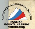
- R30: 5 m, 35°. From here, along a ledge, we exit under the summit pinnacle. A smooth wall is passed partly with the help of artificial aids.
- R31: 20 m, 75°. At the top is a 3rd category difficulty cairn. Here lie rappel ropes, platforms, and galoshes from previous climbers. On the left part of the ledge.
- R32: 2000 m, 20°. Connects to the snowy slope of a wide ridge. Further along the ridge, overcoming gendarmes and rock outcrops, we reach the summit. The altitude begins to take its toll. Our group is the first this year to traverse the ridge. It is so fragile in places that we have to cut away a lot of ice and snow for safe passage. This takes a lot of effort and time. Bivouac in the immediate vicinity of the summit. In the snowy ridge, we cut out a platform. For the day, 12 hours of work.
August 2, 1984
After 2 hours of movement along the ridge, we reach the summit of Peak Engels. We retrieve a note from the team of the Moscow City DSO "Burevestnik". They reached the summit via the Western ridge an hour before us. Following their tracks, we begin our descent. After an overnight stay on the Western ridge on August 3, we descend to the base camp.
Photo 11. Lower part of the bastion. Exit to the cornice. Section R4.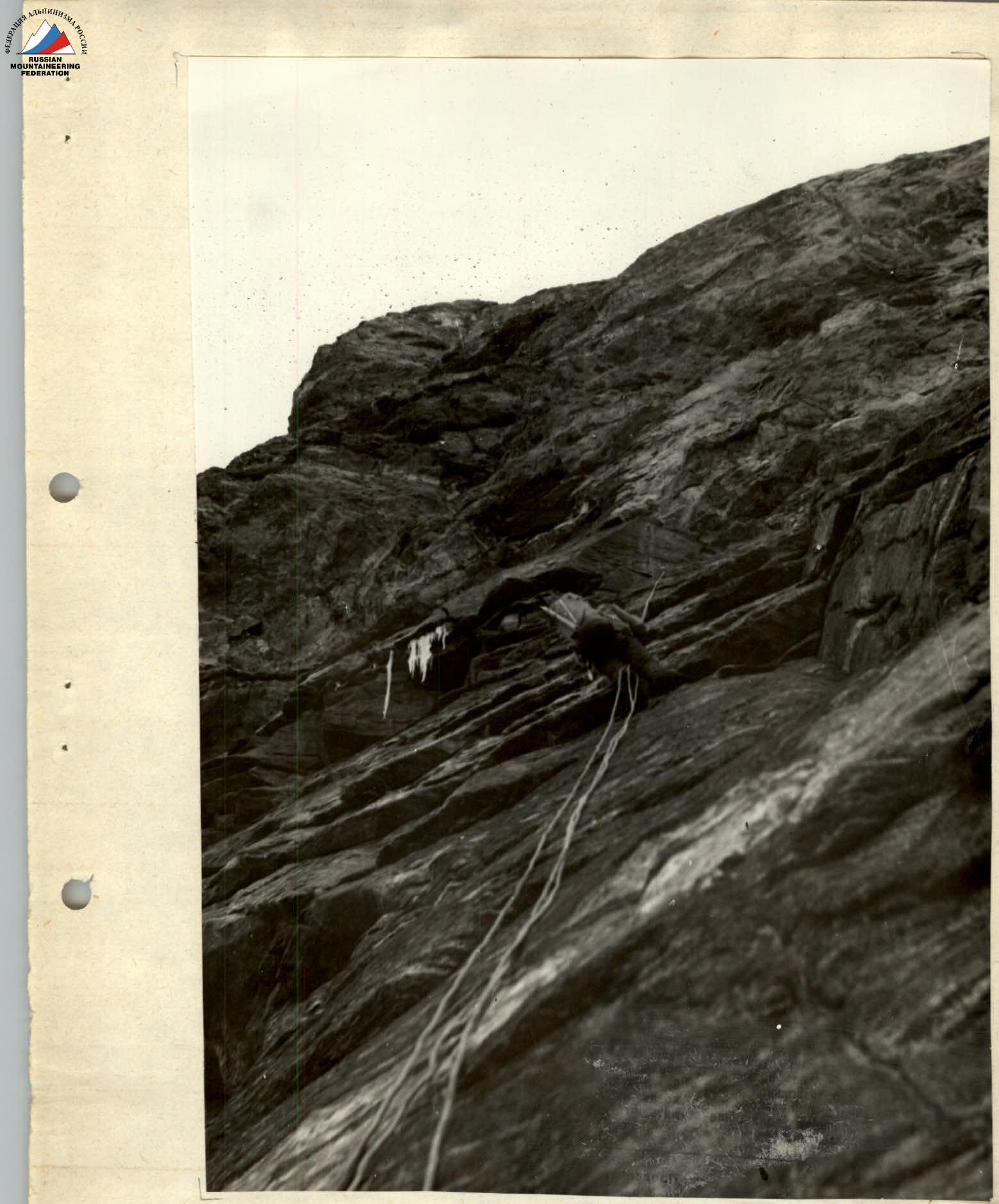
Photo 2A. Top of the bastion. Sections R8–R12. Shot from the Kustovsky route.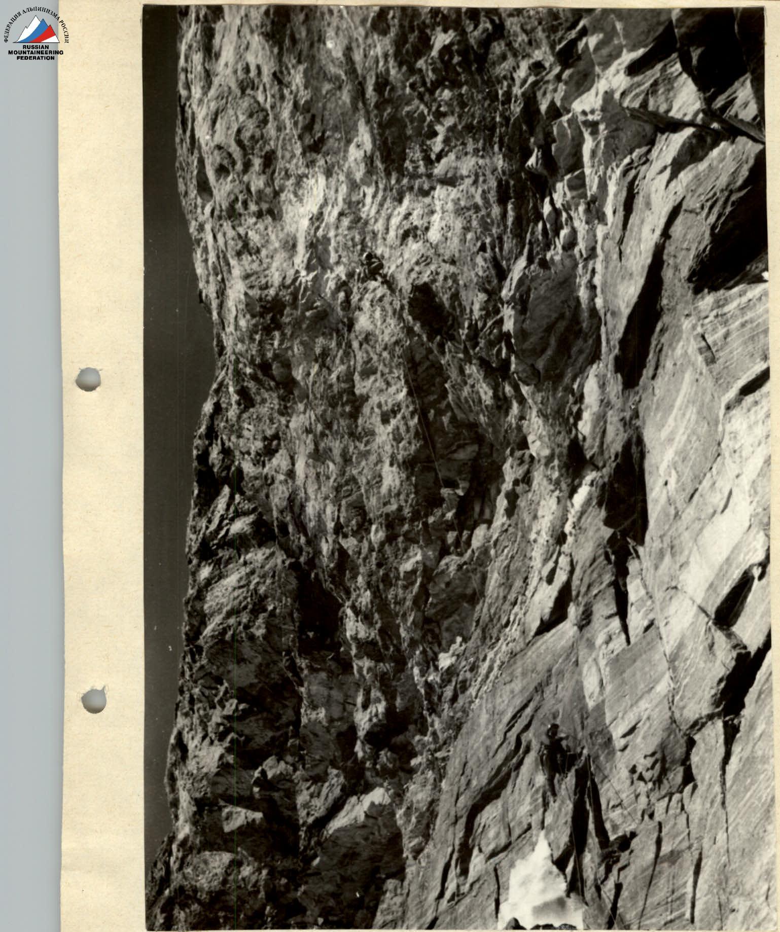
Photo 3. Passage of the grey wall with cornices. Section R23.
Photo 4. Passage of the overhanging red wall. Section R26.