4.17.100
1. Geographical Location and Sporting Characteristics
Peak named after F. Engels (6510 m) is located in the central part of the Shakhdarin Range (South-West Pamir). For the first time, a mountaineering expedition worked in the area of Peaks Marx and Engels in 1946. Since then, mountaineering expeditions have been entering this area almost every year to make ascents. The area is attractive due to the presence of a large number of diverse and very complex routes. (It is enough to say that there are three routes of the highest category of complexity in this area), many of which were awarded gold medals in the USSR mountaineering championship.
The route planned for the ascent was first passed by a group of climbers led by Z.M.S. V. T. Romanov. It is a wall oriented to the southwest. The length of the wall is about 1500 m. The ascent on such a route is a very complex task, since the route starts at 5100 m and ends at an altitude of 6510 m.
2. Meteorological Conditions
The region of South-West Pamir is characterized by stable weather in July-August. However, due to the climatic peculiarities of this year, the weather in the ascent area was not stable.
Engels Peak is composed of marble and granite. Along the route, there are sections composed of destroyed and strong rocks. In some places, the passage of sandstone is a great danger. The object of the ascent is located at a great distance from the mountaineering bases. The nearest "Varzob" camp is located at a distance of approximately 700 km. To approach Engels Peak, it is best to use the Osh-Khorog or Dushanbe-Khorog-Osh road. The car goes as far as the village of Ior or Lyangar, and then by pack transport up the trail for about 5 hours. The base camp can be set up on the bend of the river.
Despite the work of several expeditions, it is practically very difficult to obtain clear materials about the area.
3. Ascent Plan
The group of climbers from Novosibirsk began to prepare for the ascent to Engels Peak in the autumn of 1969. Mandatory for all team members were:
- participation in athletics competitions,
- participation in skiing competitions,
- swimming,
- rock climbing.
The participants of the assault group had ascents to Peak Lenin, Peak Svobodnaya Korea (via the Myshlyaev route), Peak Simagina, and others behind them. All this made it possible to hope that the ascent would be successful.
In April, the following plan of action was outlined:
- Participation in the May mountaineering competition in the Almaty area.
- Departure from Novosibirsk on July 8-10.
- Training ascents – July 14-22.
- Rest July 23-28.
- Departure to the route on July 29-30.
- Completion of the route on August 8-9.
In reality, the entire planned plan was implemented with a significant time shift of 3-4 days. After organizing the base camp on July 19, the entire sports group of 17 people went to acclimate to the camp area at 4800 m. At the same time, food supplies were made and reconnaissance of the area of the upcoming ascents was carried out. Then, on July 22, the main members of the assault group made a training ascent to Peak Babel (6010 m) via the 5A category route. After resting and observing the planned route, a tactical plan for the ascent to Engels Peak was outlined.
Ascent plan:
- July 30 — departure to Camp 5100 m under the start of the route.
- July 31 — passage of the snow-ice part of the route.
- August 1 — movement along the not clearly defined counterfort.
- August 2 — movement along the counterfort.
- August 3 — exit under the gray rocks (1st rock band).
- August 4 — exit under the marble belt.
- August 5 — overcoming the pre-summit walls.
- August 6 — exit to the ridge of the Shakhdarin Range.
- August 7 — exit to the summit and descent to the camp.
- August 8 — carrying due to bad weather.
During the ascent, this plan was somewhat adjusted due to bad weather and the great difficulties of passing certain sections of the route. For the ascent, the group had a wide range of mountaineering equipment at its disposal: titanium pitons, titanium ice screws, boulder pitons, titanium carabiners, titanium and duralumin wedges, as well as rope-climbing devices.
4. Assault Group
Based on the results of winter training and participation in the ascent in the spring and summer of 1970, the coaching council formed an assault group consisting of:
- SERGEZNOV A. N. — Master of Sports, captain
- KALUZHKSY L. A. — Master of Sports, deputy captain
- BOGOMOLOV A. S. — Master of Sports
- SARATOVKIN V. L. — Candidate for Master of Sports
- TERESCHENKO V. A. — Candidate for Master of Sports
- BOGOMOLOV A. M. — Candidate for Master of Sports
- KAREV V. V. — Candidate for Master of Sports
- KASPIROVICH G. E. — Candidate for Master of Sports
On July 30, the assault group departed to Camp 5100 m.
5. Evaluation of the Ascent Participants
All participants of the ascent proved themselves to be true athletes, able to overcome difficulties on the route. It can be noted that they are all worthy of making ascents of the highest category of difficulty.
6. Additional Data on the Route
The team members had a number of complex ascents in their active: Ushba via the south wall, Peak Svobodnaya Korea (via the Myshlyaev route), Peak Simagina via the North wall, Karakolsky Peak via the NE edge, and others, but the group unanimously believes that the route passed is undoubtedly the most difficult. And we agree with B. T. Romanov's statement that this is undoubtedly a 6B category route, one of the most complex in the USSR.
Our group, like Romanov's group, did not find a cairn on the summit, and no control cairn was found along the route. The group built a cairn on the summit and left a commemorative pennant in it, dedicated to the 150th anniversary of F. Engels. The reliability of the ascent can be confirmed by V. Monogarov, a member of the USSR Mountaineering Federation, and Master of Sports V. Benkin, whose team made the ascent via the route following us.
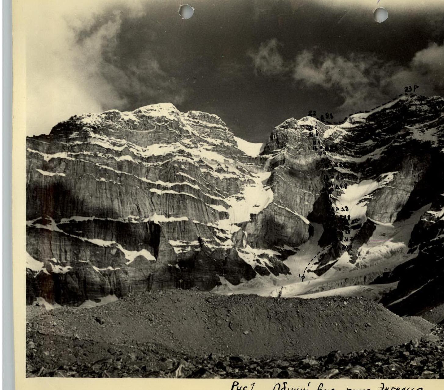
Fig. 1. General view of Engels Peak. Δ — overnight stays; — — — path.
7. Table
MAIN CHARACTERISTICS OF THE ASCENT ROUTE: ASCENT ROUTE: SOUTHWEST WALL OF Engels Peak ELEVATION GAIN: ABOUT 1500 m INCLUDING MOST DIFFICULT SECTIONS: 480 m STEEPNESS OF THE ROUTE: 81° INCLUDING MOST DIFFICULT SECTIONS: 90°
| Date | Section traversed | Average steepness of section | Length of section | Characteristics of sections: by relief | Characteristics of sections: by technical difficulty | Weather/conditions | Description | Time | Pitons driven Rock | Pitons driven Ice | Hauling of backpacks | Overnight stay |
|---|---|---|---|---|---|---|---|---|---|---|---|---|
| 30.07 | R1–R2 | 60° | 300 m | ice | difficult | good | 8 ч | 15 | 20 | |||
| 31.07 | R2–R3 | 80° | 100 m | rocks | difficult | good | 4 ч | 15 | ||||
| 01.08 | R3–R4 | 80° | 40 м | rocks | most difficult | good | negative section 7–10 m | 4 ч | 25 | Hauling backpacks | Lying | |
| 01.08 | R4–R5 | 85° | 80 м | rocks, snow, ice | very complex | good | 3 ч | 15 | ||||
| 01.08 | R5–R6 | 90° | 80 м | rocks | most difficult | satisfactory | negative section 5–10 m | 6 ч | 25 | Hauling backpacks | Sitting | |
| 02.08 | R6–R7 | 80° | 120 м | rocks with ice | very complex | satisfactory | wall with overhanging ice 10 m | 6 ч | 18 | Hauling backpacks | ||
| 02.08 | R7–R8 | 75° | 80 м | rocks, snow | complex | satisfactory | 4 ч | 12 | Hauling backpacks | Sitting | ||
| 03.08 | R8–R9 | 90° | 120 м | rocks | very complex | snow, wind | smooth slabs | 6 ч | 20 | |||
| 03.08 | R9–R10 | 85° | 80 м | rocks, ice | very complex | snow, wind | wall with overhanging ice | 5 ч | 12 | Hauling backpacks | ||
| 03.08 | R10–R11 | 90° | 40 м | rocks | pre-most difficult | snow, wind | negative slab | 3 ч | 20 | Hauling backpacks | Sitting | |
| 04.08 | R11–R12 | 90° | 200 м | rocks | most difficult | fog, snow | Walls with negative sections | 8 ч | 25 | Hauling backpacks | ||
| 04.08 | R12–R13 | 70° | 120 м | snow, ice, rocks | complex | fog, snow | 3 ч | 15 | 5 | Hauling backpacks | ||
| 05.08 | R13–R14 | 90° | 60 м | rocks | pre-most difficult | fog | marble slabs | 16 ч | 35 | Hauling backpacks | Sitting | |
| 05.08 | R14–R15 | 60° | 40 м | ice, snow | complex, very | satisfactory | 2 ч | 5 | 2 | Sitting | ||
| 06.08 | R15–R16 | 80° | 200 м | rocks, ice, snow | very complex | good | negative rock slab 3 m | 6 ч | 20 | 5 | ||
| 06.08 | R16–R17 | 90° | 80 м | rocks | most difficult | snow | smooth slabs | 6 ч | 30 | Hauling backpacks | Sitting | |
| 07.08 | R17–R18 | 60° | 40 м | rocks, ice | complex | snow | rocks with ice | 2 ч | 5 | Sitting | ||
| 07.08 | R18–R19 | 90° | 40 м | rocks | most difficult | good | negative section | 3 ч | 10 | |||
| 07.08 | R19–R20 | 85° | 120 м | rocks, ice, snow | very complex | good | 5 ч | 25 | ||||
| 08.08 | R20–R21 | 90° | 40 м | rocks | pre-most difficult | satisfactory | smooth slabs | 4 ч | 10 | Hauling backpacks | half-lying | |
| 08.08 | R21–R22 | 75° | 80 м | rocks, ice | very complex | satisfactory | rock wall with ice and snow | 4 ч | 8 | 2 | on the ridge | |
| 08.08 | R22–R23 | 45° | 400 м | ice, snow, rocks | from strong | icy rocks, frost | 3 ч | 4 | ||||
| average steepness | 81° | 2440 м | 110 ч | 349 | 39 |
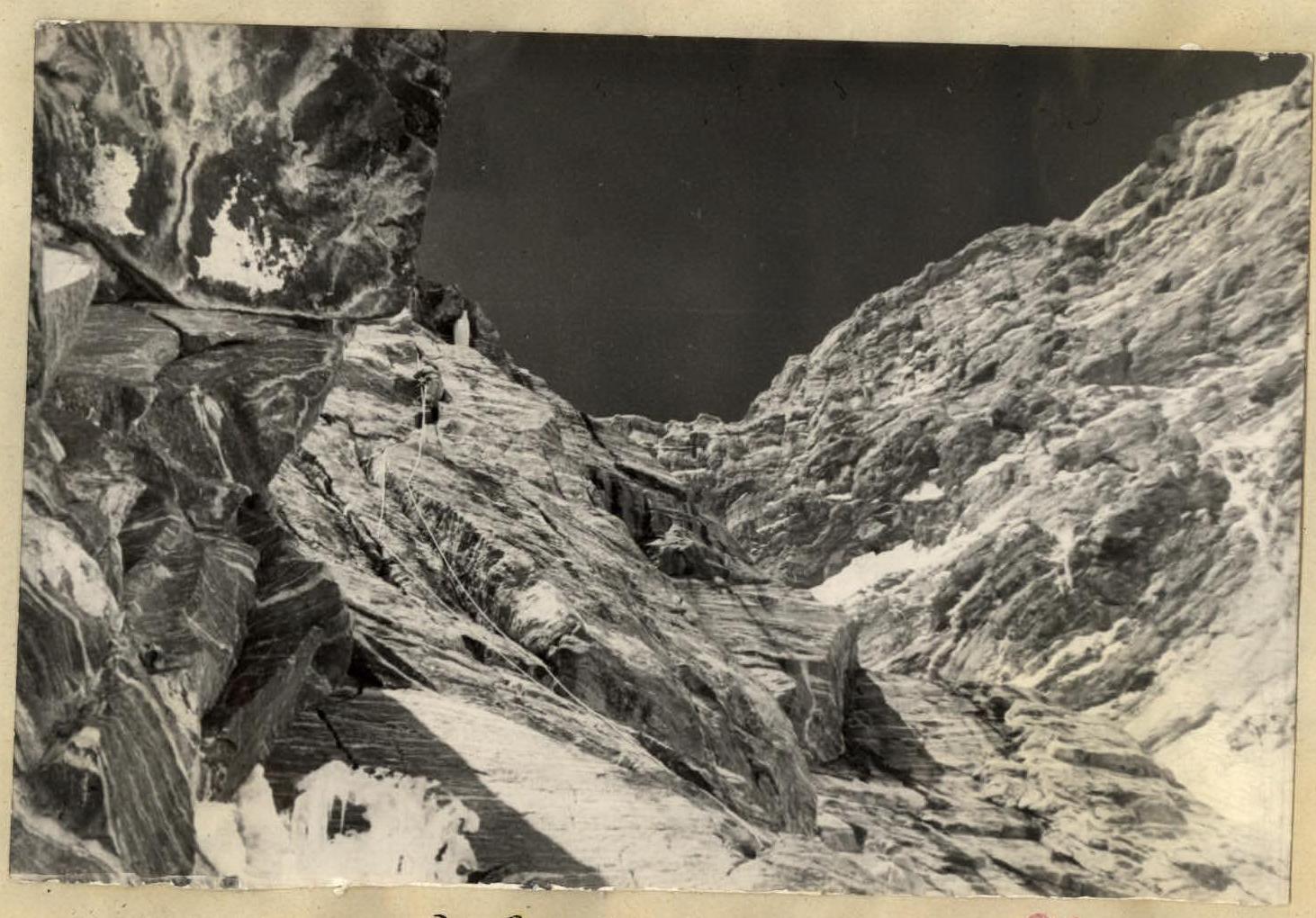
Fig. 6. On the section R11–R12.
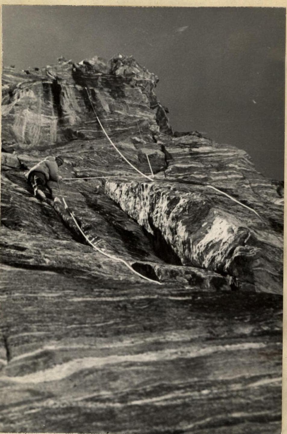
Fig. 9. On the section R13–R14. (?) This is a repeat of the section R11–R12!