I. Climbing category — altitude-technical. 2. Climbing area — South-West Pamir, Shakhdarinsky ridge. 3. Peak, its height, route — Peak TGU 6183 m, via the left edge of the Eastern wall. 4. Difficulty category — 6B. 5. Route characteristics: height difference of the wall section 1000 m, total 1183 m, length of 6th category sections — 754 m, length of 5th category sections — 407 m, average steepness of the wall section 78°. 6. Pitons hammered: for rock belay 252, bolted 5, for creating artificial climbing holds (ACH) rock 106. 7. Number of climbing hours 72.5 (10 for route reconnaissance). 8. Number of bivouacs and their characteristics: 5 bivouacs on the wall, including: three semi-reclining, two reclining. 9. Surname, name, patronymic of the team leader, participants and their qualification: Team leader: Varov Viktor Ivanovich — CMS (Candidate Master of Sports). Participants: Parshin Vladimir Sergeevich — CMS, Antipin Vitaly Mikhailovich — CMS, Martirosyan Albert Aleksandrovich — CMS, Arsentyev Sergey Anatolyevich — CMS, Sazanov Viktor Vasilyevich — CMS, Solovyov Sergey Aleksandrovich — CMS, Mozhaev Mikhail Vasilyevich — CMS, Zander Sergey Egonovich — CMS, Tulaev Ivan Ivanovich — CMS. 10. Team coach — Troshchinenko Leonid Andreyevich, Honored Master of Sports of the USSR.
II. Dates of departure and return:
- Departure from base camp — August 12, 1982.
- Start of the route (reconnaissance) — August 13.
- Ascent — August 14–19.
- Descent — August 20–21.
- Return to base camp — August 21, 1982.
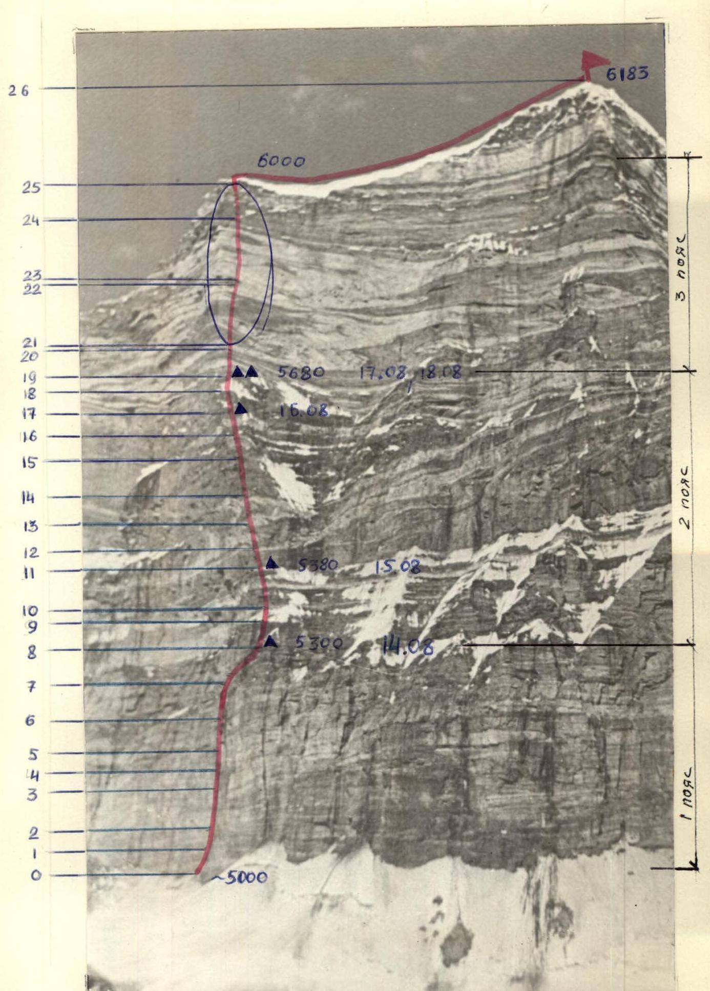
Kartvelishvili Route
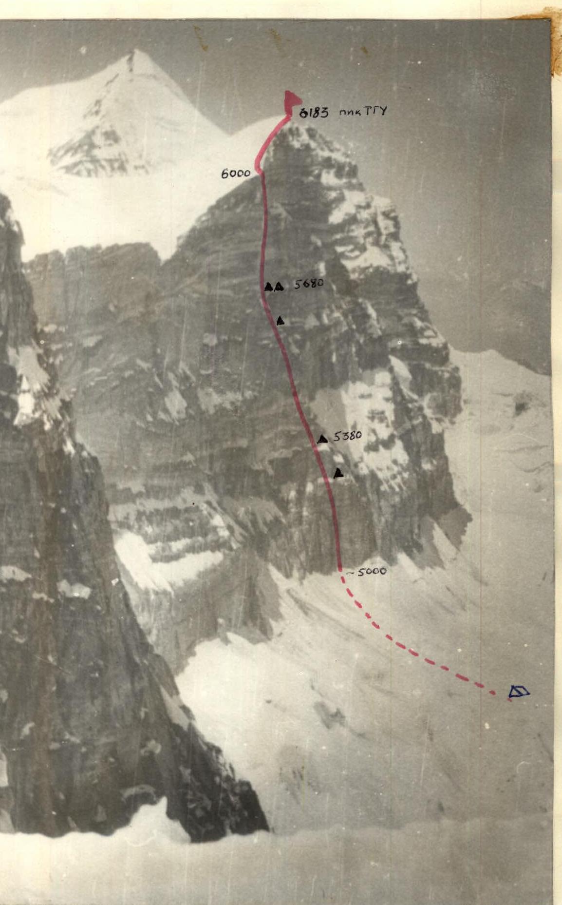
Route Profile
Brief explanation of the table of main route characteristics
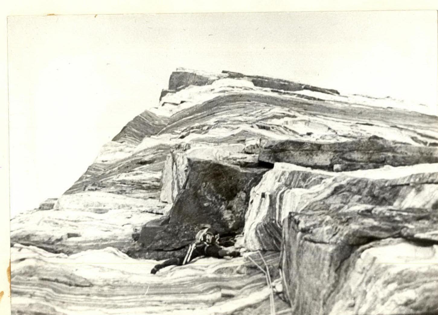
- R0–R1 Wall, monolith, live rocks on the shelves.
- R1–R2 Inner corner turning into a crack, climbing with ACH.
- R2–R3 Vertical inner corner.
- R3–R4 Alternating steep walls with small inclined shelves.
- R4–R5 Inner corner with destroyed walls (Caution!).
- R5–R6 Wall with destroyed rock, live rocks.
- R6–R7 Wall with overhanging sections, upper part is crumbling.
- R7–R8 Inclined scree shelf, many live rocks, being hit by rocks from the upper part of the wall.
- R8–R9 Wall with good holds, monolith.
- R9–R10 Ice and snow slope in the form of a calga spr.
- R10–R11 Large slabs alternating with shelves, right part is being hit by rocks from above.
- R11–R12 Inner corner, steep, go on the right part. At the top, go left to the edge for 8 m.
- R12–R13 Monolithic edge, climbing with reliable holds.
- R13–R14 Inner corner ending with a shelf, climbing is difficult.
- R14–R15 Wall, monolith with good cracks for pitons.
- R15–R16 Edge, hold on to the left part.
- R16–R17 Crumbly wall, live rocks.
- R17–R18 Alternating inner corners with destroyed rock.
- R18–R19 Ice and snow slope in the form of a calga spr.
- R19–R20 Inner corner closing with a cornice.
- R20–R21 Traverse of the cornice to the left upwards.
- R21–R22 Inner corner turning into a wall at the top.
- R22–R23 Traverse of the cornice to the right upwards.
- R23–R24 Wall, very steep, ACH, rocks are solid.
- R24–R25 Weathered limestone, wall, rockfall hazard during the start of snowmelt.
- R25–R26 Ice and snow ridge.
- 4 -

TABLE OF MAIN CHARACTERISTICS OF THE ASCENT ROUTE TO PEAK TGU / 6183 m / VIA THE LEFT EDGE OF THE EASTERN WALL, SIXTH CATEGORY OF DIFFICULTY / SECOND ASCENT OF KARTVELISHVILI ROUTE — 1st PLACE AT THE USSR CHAMPIONSHIP 1979 IN THE CLASS OF ALTITUDE-TECHNICAL ASCENTS/
Route length — 1641 m. Route height difference — 1183 m. Length of most difficult sections — 6th cat. 754 m, 5th cat. 407 m. Route steepness / wall section / 78°
| Date | Sections covered | Avg. steepness | Section length | Terrain characteristics | Diff. cat. | Overcoming method | Weather conditions | Bivouac stops | Departure | Climbing hours | Pitons hammered: rock | bolted | Bivouac conditions |
|---|---|---|---|---|---|---|---|---|---|---|---|---|---|
| August 13 | R0–R1 | 80° | 30 m | Wall | 6 | Free climbing | Good | 18:00 | 8:00 | 10 | 10 | Under the wall | |
| Reconnaissance | R1–R2 | 90° | 25 m | Crack | 6 | Climbing with ACH | 8 | ||||||
| R2–R3 | 80° | 40 m | Inner corner | 6 | 13 | ||||||||
| R3–R4 | 75° | 20 m | Wall | 5 | Free climbing | 6 | |||||||
| R4–R5 | 75° | 30 m | Inner corner | 6 | 8 | ||||||||
| R5–R6 | 78° | 35 m | Destroyed wall | 6 | 16 | ||||||||
| R6–R7 | 80° | 40 m | Wall with overhangs | 6 | Climbing with ACH | 14 | |||||||
| Total for the reconnaissance day | 220 m | 75 | Reclining Aug 14 | ||||||||||
| August 14 | R7–R8 | 50° | 160 m | Inclined scree shelf | 4 | Free climbing | 18:00 | 9:00 | 9 | 6 | |||
| Team departure on the route | R8–R9 | 75° | 40 m | Wall | 5 | 19:00 | 19:00 | 10 | 10 | ||||
| R9–R10 | 50° | 45 m | Calga spr | 5 | 14 | 2 | |||||||
| R10–R11 | 75° | 130 m | Monolithic slabs | 5 | 16 | ||||||||
| R11–R12 | 85° | 35 m | Inner corner | 6 | Climbing with ACH | 10 | |||||||
| R12–R13 | 75° | 43 m | Monolithic edge | 6 | Free climbing | 14 | |||||||
| August 15 | R13–R14 | 85° | 45 m | Inner corner | 6 | Free climbing ACH | 21 | 1 | Reclining Aug 15 | ||||
| R14–R15 | 85° | 42 m | Wall | 6 | Free climbing | 12 | |||||||
| Total for Aug 14–15 | 540 m | 82 | 2 | ||||||||||
| August 16 | R15–R16 | 70° | 50 m | Edge | 5 | 18:00 | 8:00 | 10 | 10 | Semi-reclining Aug 16 | |||
| R16–R17 | 65° | 45 m | Destroyed wall | 5 | 8 | ||||||||
| R17–R18 | 70° | 42 m | Destroyed wall with inner corners | 5 | 10 | ||||||||
| R18–R19 | 55° | 35 m | Calga spr | 5 | Climbing with ACH | 2 | |||||||
| R19–R20 | 85° | 35 m | Wall | 6 | 15 | ||||||||
| Total for August 16 | 207 m | 43 | 2 | ||||||||||
| August 17 | R20–R21 | 120° | 3 m | Traverse of cornice | 6 | 19:00 | 7:00 | 12 | 6 | Semi-reclining Aug 17 | |||
| R21–R22 | 90° | 140 m | Inner corner | 6 | 60 | ||||||||
| R22–R23 | 110° | 6 m | Traverse of cornice | 6 | 10 | ||||||||
| Total for August 17 | 149 m | 76 | 3 | ||||||||||
| August 18 | R23–R24 | 90° | 130 m | Destroyed wall | 6 | 19:00 | 7:00 | 7:00 | 56 | 2 | Semi-reclining Aug 18 | ||
| Total for August 18 | 130 m | 56 | 2 | ||||||||||
| August 19 | R24–R25 | 85° | 75 m | Destroyed wall | 6 | Windy, cloudy | 11 | ||||||
| R25–R26 | 30° | 320 m | Snow, firn | 3 | 17:00 | 7:30 | 9:30 | 16 | |||||
| Total for wall section | 1321 m | ||||||||||||
| Total | 1641 m | 72.5 | 358 | 4 | 5 |