Passport
- Technical Climbing Category
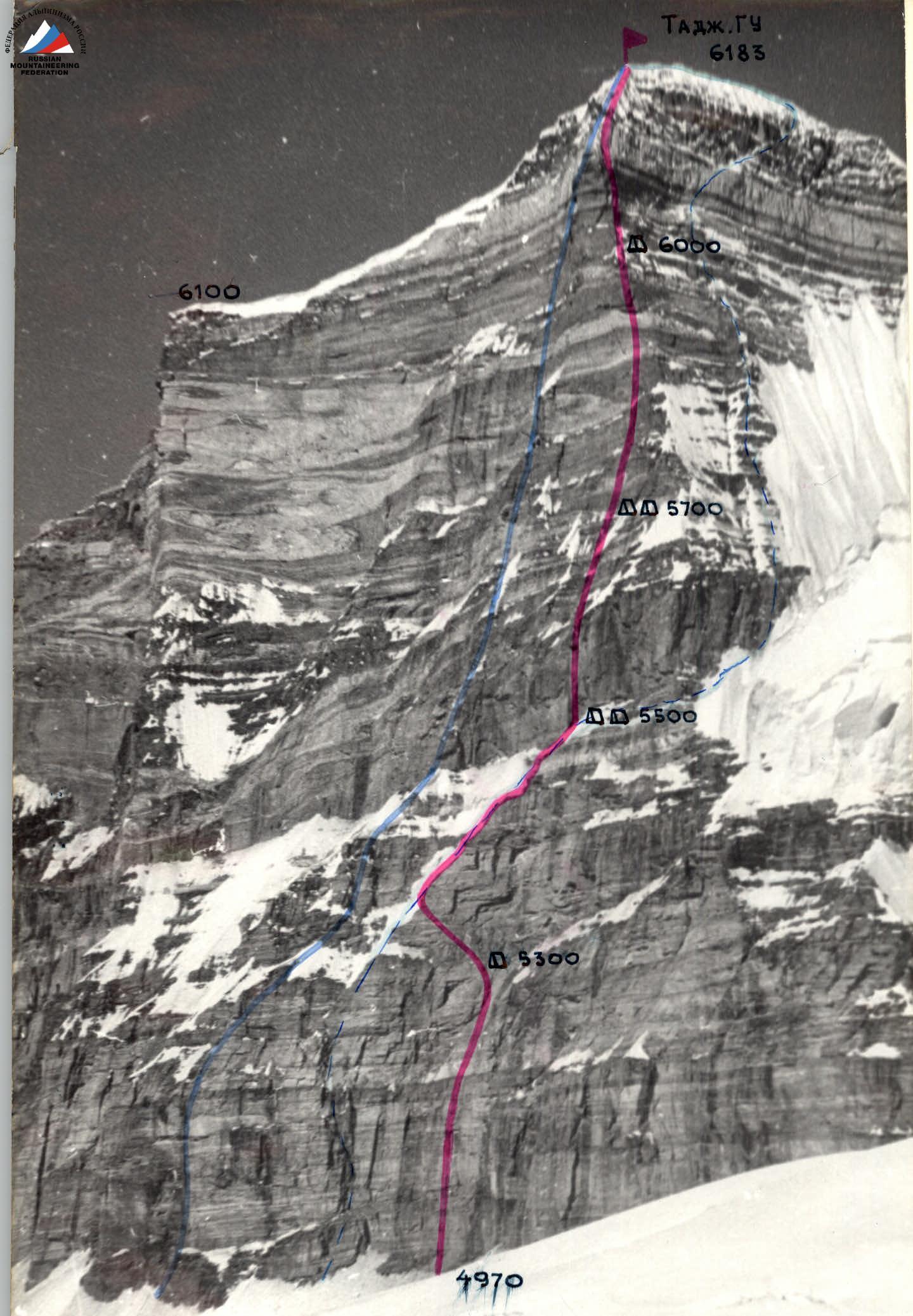
- South-West Pamir, Shakhdarin Range
- Peak Tajikistan GU, center of the eastern wall of the main summit 6183 m
- Proposed — 6B category of difficulty, first ascent
- Height difference — 1210 m, length — 1300 m
- Length of sections with 5–6B category of difficulty — 1020 m including 6B category of difficulty — 440 m. Average steepness of the route — 72–73°
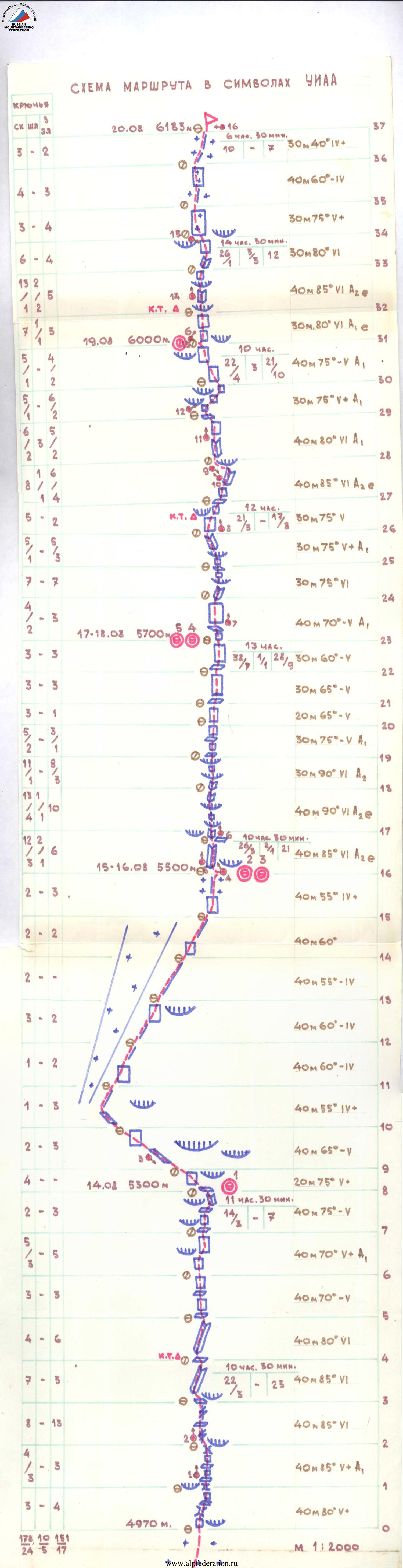
- Pitons hammered:
| Rock Pitons | Bolt Pitons | Nuts |
|---|---|---|
| 178⁄24 | 10⁄5 | 151⁄17 |
-
Climbing hours — 79, days — 7 and one day for processing (10 h 30 min)
-
Overnight stays: 1st — lying, 2–3, 4–5 — lying on artificially created platforms, 6th — sitting
-
Team Leader: Smirnov Vadim Anatolyevich — Master of Sports of International Class
Team Members: Valiev Kazbek Shakimovich — Honored Master of Sports, Khrshchaty Valery Nikolaevich — Honored Master of Sports, Chepchev Sergey Georgievich — Honored Master of Sports, Lunakov Grigory Evgenievich — Master of Sports, Andrienko Valery Pavlovich — Candidate for Master of Sports, Vorobiev Alexander Sergeevich — Candidate for Master of Sports, Vinokurov Nikolai Fedorovich — Candidate for Master of Sports, Moiseev Yuri Mikhailovich — Candidate for Master of Sports, Suviga Vladimir Ivanovich — Candidate for Master of Sports
-
Senior Coach: Ilyinsky Ervand Tikhonovich, Honored Coach of the USSR, Honored Master of Sports
Coach: Sedelnikov Viktor Nikolaevich, Honored Coach of the Kazakh SSR, Master of Sports of International Class
-
Processing day: August 13, 1983
Departure to the route: August 14, 1983 Summit: August 20, 1983 Return: August 21, 1983
Tactical Actions of the Team
The team's actions during the ascent were determined by the tactical plan. Throughout the entire route, the first climber went on a double rope (photo 2). Initially, almost all team members worked as the first climber, taking turns and changing each other, which allowed for a more even distribution of physical and psychological load on each team member.
The route was climbed with preliminary processing (sections R0–R4) of the lower part of the wall, and further processing was done during the ascent (sections R16–R23, R23–R30, and R31–R34) from intermediate overnight stays.
Due to the good team cohesion, uniform physical and technical preparation, and mutual understanding among team members, there were no fixed rope teams. The composition of the rope teams changed throughout the route. The leading rope teams were changed on sections 3, 8, 16, 17, 19, 23, 25, 30, 32, and 34. When processing, the working rope teams changed during the day, working an average of 4–5 hours, allowing the team to work intensively for 11–13 hours a day throughout the route.
Perils were organized along the entire length of the route. Overnight stays were organized in safe, protected areas, well-studied during observations of the wall. The first overnight stay was under a large ledge on a snow-ice shelf (section 8–9).
The second, third (section 16–17) and fourth, fifth (section 23–24) overnight stays were organized on inclined rock shelves, which were artificially enlarged. They were also under the protection of ledges. The preparation of platforms for tents was carried out simultaneously with the preliminary processing of the route by team members not involved in the processing. The effort spent on preparing the platforms was fully justified by the quality rest.
The sixth overnight stay was organized on two small ledges (section R31–R32, photo 13) using specially prepared hammocks under the tent, which allowed for an increase in the size of the platform and created additional support for the legs.
The lower part of the route is a system of steep monolithic walls with a small number of holds, partially dissected by vertical wide cracks. A diverse set of protection elements allowed for the acceleration of the passage of complex sections. The lower part of the wall is prone to rockfall, with rocks falling from the upper snow-covered scree shelves, especially between 11:00 and 16:00, so it was decided to depart in separate groups of five (by tents).
The first group of five departed early in the morning.
Having passed the pre-processed section, they hung four more ropes to the overnight stay location (section 4–8).
 The second group of five departed after 16:00.
The middle part of the route is a system of steep internal corners and ledges (photo 4), requiring the use of artificial technical means (IT).
The upper part of the route is a very steep section of the wall intersected by white bands (marbled limestone). At the boundaries of the white and dark bands, ledges form, and their large size required the use of the entire arsenal of rock climbing techniques.
The descent from the summit of Peak Tajikistan GU did not present any technical difficulties. A vehicle was sent to meet the team in the village of Nishgar.
During the ascent, pitons made of titanium alloys were used. Nuts were frequently used, significantly reducing the time required to organize intermediate protection points. They slept in high-altitude VTsPS (All-Union Central Council of Trade Unions) tents without inner liners. Hammocks made for the tents allowed for a secure setup on small ledges.
There were no falls, injuries, or illnesses. Communication with the observation group was maintained via VHF radio — five communication sessions per day.
Observers maintained constant visual monitoring of the team's actions using a 60x spyglass.
The observation group was located on the Bezymanny Pass (approximately 5000 m). The observation group had a constant connection with the base camp and, through it, with the KSP (Climbing and Sports Organization) in Dushanbe.
Section R0. Beginning of the route: — steep monolithic wall, holds are heavily worn; — insurance spot is convenient, protected by a ledge; — up the wall along a crack; — then a small traverse to the right into a chimney.
Section R1–R2. Photo 1. The section consists of small steep monolithic walls alternating with inclined shelves. IT is used to climb the walls.
Section R2–R3. Under the ledge, we move left to a steep smooth slab, climbed via a crack. The crack initially overhangs slightly (photo 2). Insurance is mainly organized with nuts.
Section R3–R4. Along the shelf to the left into an internal corner, climbing is very difficult, with few cracks, and monolithic smooth sides. The corner is climbed on the left side, where there are several small vertical cracks. Processed on August 13.
Section R4–R5. The insurance spot is inconvenient; the corner is climbed further on the right side. Nuts go well.
Section R5–R6. Alternating fairly steep shelves with walls. Climbed left upwards.
Section R6–R7. 15 m up the wall under a ledge, which is bypassed on the right, and then up the wall — exit to a shelf.
Section R7–R8. Straight up and along the shelf to the right, bypassing a large ledge, into an internal corner. The rocks are destroyed. Prone to rockfall. Under the ledge is a snow-ice shelf. Overnight stay.
Section R8–R9. From the overnight stay, traverse along a steep slab to the left upwards towards the ridge (photo 3).
Section R9–R10. Further, the steepness decreases. Exit to the ridge.
Section R10–R11. Exit to the ridge and along it to the right.
Section R11–R16. The ridge is not steep, heavily destroyed, with icy rocks in places. We approach under a steep rock belt. Convenient spot for an overnight stay. Under the protection of a ledge.
Section R16–R17. Very steep internal corner with smooth monolithic walls. In the lower part, two overhanging blocks. Exit from the corner to the right onto a small inclined shelf (photo 4, 5).
Section R17–R18. Under the ledge — straight up. The ledge is climbed on the left via a crack and then up the internal corner. The next small ledge is overcome in the center (photo 4, 6). Nuts go well. Climbing is very difficult, insurance is inconvenient, sitting in a harness.
Section R18–R19. Straight up the internal corner. There are two ledges on the section (photo 7). Climbing is very difficult along a crack and in the internal corner. We use nuts and a "korob" (a type of artificial aid). Exit from the ledge onto a small shelf.
Section R19–R23. The sections represent rock walls, slabs alternating with shelves convenient for insurance.
Section R23–R24. From the overnight stay to the left and upwards, a logical path is visible along the concave part of the wall.
Section R24–R25. Climbed along the internal corner and then through a small ledge on a white band (photo 7).
Section R25–R26. Upwards, the steepness decreases; we approach under a ledge. The ledge is overcome on the right side with the help of IT. Further — into an internal corner.
Section R26–R27. The corner turns into a slab with few holds; in the upper part of the slab, there are good flakes. A small ledge is bypassed on the right (photo 8), then to the right onto a shelf. Control cairn.
Section R27–R28. Along the shelf to the right upwards along a monolithic steep slab, few holds. Further up the slab into a very steep internal corner (photo 9), which abuts a large (2 m) ledge. Under the ledge, along the slab — traverse to the left and upwards (photo 10) into an internal corner. The section is very complex; nuts go well.
Section R28–R29. The steep internal corner leads to a wall under large ledges. The wall is constructed like tiles from large slabs (photo 11). There is a small shelf on the wall, convenient for insurance.
Section R29–R30. From the shelf upwards and pendulum to the right under the ledge (photo 12).
Section R30–R31. Upwards, slightly deviating to the right along a wall with few holds, holds are heavily worn. Insurance is reliable, on rock pitons. Above the wall is a belt of heavily destroyed rocks, where we organize an overnight stay (photo).
Section R31–R32. From the overnight stay straight up — steepness increases (photo 13). The wall is intersected by a large two-meter ledge. Under the ledge is a niche, a convenient spot for insurance. Control cairn.
Section R32–R33. The ledge is climbed straight on. The exit from the ledge is very difficult, then along a complex internal corner ending in a ledge (photo 14).
Section R33–R34. Up the steep wall to the left towards the pre-summit ridge. Climbing is very difficult (photo 15).
Section R34–R35. To the left upwards, a 30 m wall. From above, a snow cap — the beginning of the pre-summit ridge. The wall is covered with ice, climbed in crampons.
Section R35–R37. The ridge is climbed on the left side. Rock walls alternate with steep couloirs filled with snow and ice. Exit to the summit through a snow ledge.
Equipment Table
| № | Equipment Name | Quantity | Use on Sections | Weight (kg) |
|---|---|---|---|---|
| 1. | Main Rope | 10 × 40 | R0–R37 | 27.0 |
| 2. | Titanium Karabiners "Ir-bis" | 60 | R0–R37 | 4.5 |
| 3. | Rock Pitons | 70 | R0–R37 | 4.1 |
| 4. | Bolt Pitons Bolt Pitons | 2 20 | R16–R18, R27–R29, R32–R33 | 0.5 |
| 5. | Ice Axes | 4 | Not used | 0.4 |
| 6. | Nuts | 35 | R0–R37 | 2.0 |
| 7. | Extension Loops | 10 | R0–R37 | 0.9 |
| 8. | 3-step Ladders | 4 | 0.6 | |
| 9. | Rock Hammers | 3 | R0–R37 | 1.8 |
| 10. | Crampons | 1 pair | R34–R37 | 1.0 |
| 11. | Ice Axe | 2 | 2.0 | |
| 12. | High-altitude Tent with Poles (without inner liner) | 2 | On overnight stays | 10.0 |
| 13. | "Febus" Stove | 2 | Food preparation | 1.8 |
| 14. | Pots | 2 | Food preparation | 0.4 |
| 15. | Hammocks for Tents | 2 | Overnight stay 6 | 1.0 |
| 16. | VHF Radio Station | 1 | For radio contact | 0.8 |
| 17. | Power Supply for Radio Station (reserve) | 1 | 0.1 | |
| 18. | First Aid Kit | 1 | 1.0 | |
| 19. | Lantern | 2 | On overnight stays | 0.5 |
| 20. | Karimat | 4 | On overnight stays | 0.8 |
| 21. | Climbing Ascenders | 20 | R0–R37 | 2.0 |
| 22. | Down Jacket | 10 | 12.0 | |
| 23. | Down Sleeping Bag | 10 | On overnight stays | 15.0 |
TOTAL: 89.2
Weight of food: 10 people × 8 days × 400 g = 32.0 kg. Fuel: 10 days × 2 cans × 0.5 l = 20 l
The initial weight of the backpacks was 16–17 kg, and on the wall, it did not exceed 13–13.5 kg.
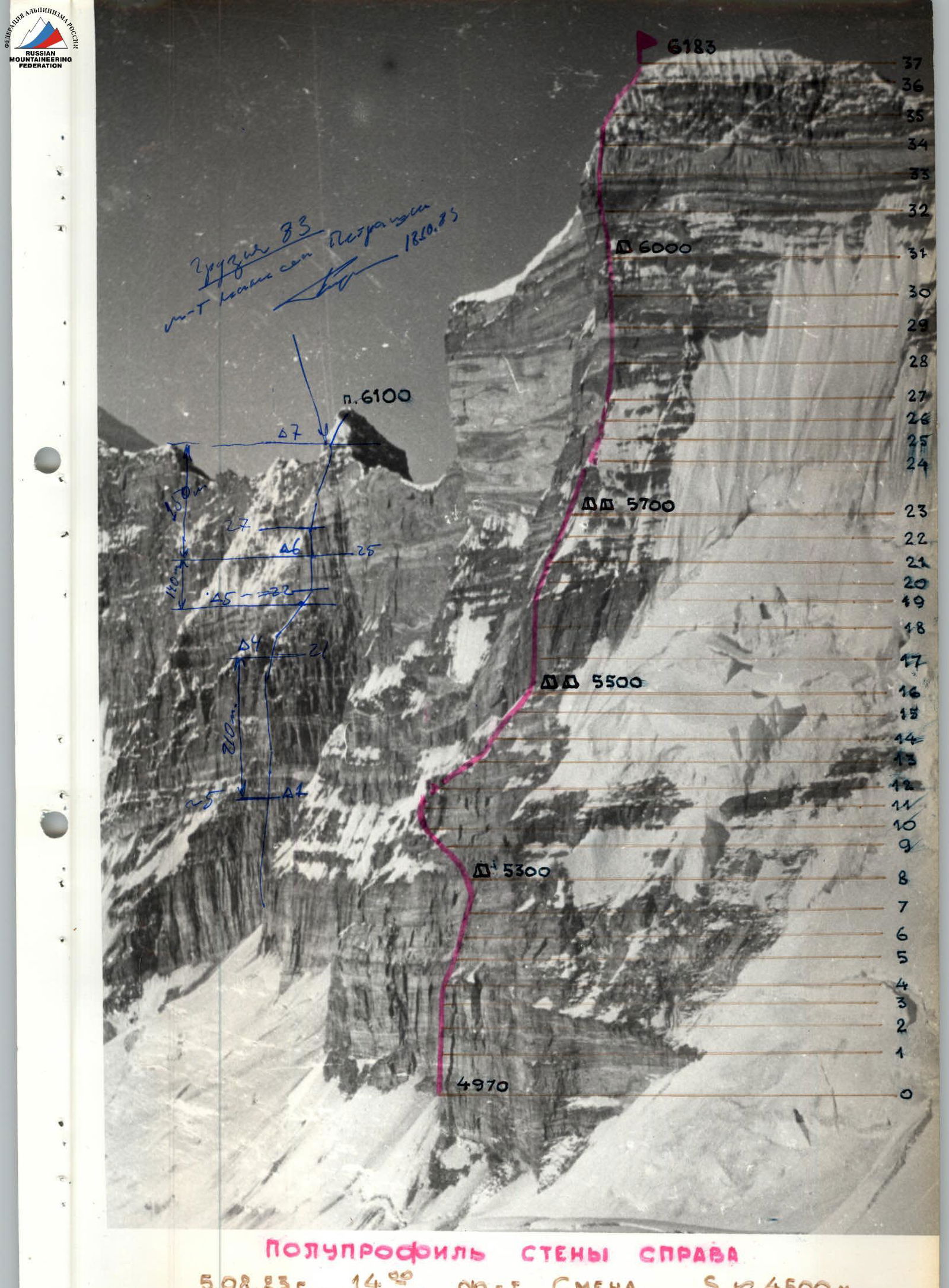
Semi-profile of the Wall on the Right
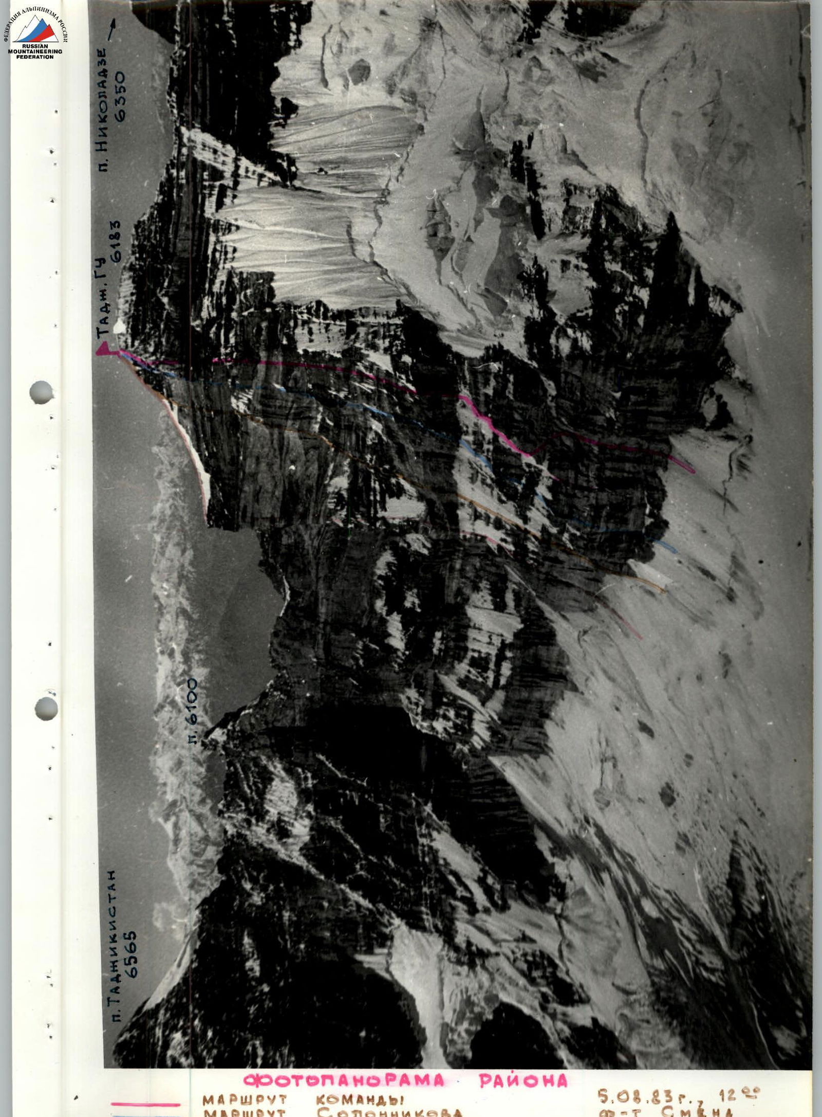
Photopanorama of the Area
— Team's Route — Solonnikov's Route — Krasnoshchekov's Route — Popenko's Route
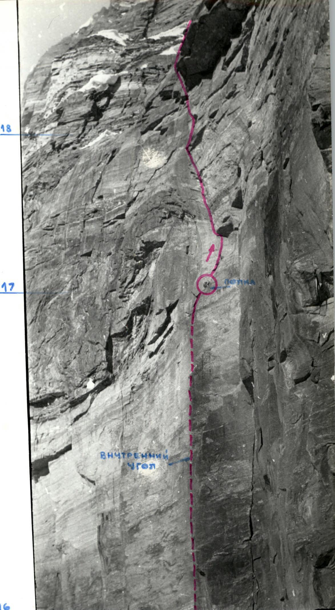
Photo 4 (sections R16–R18)
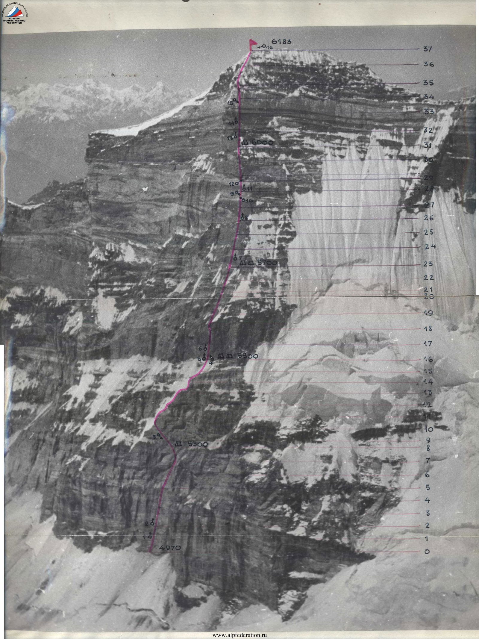

Photo 7 (sections R24–R26)
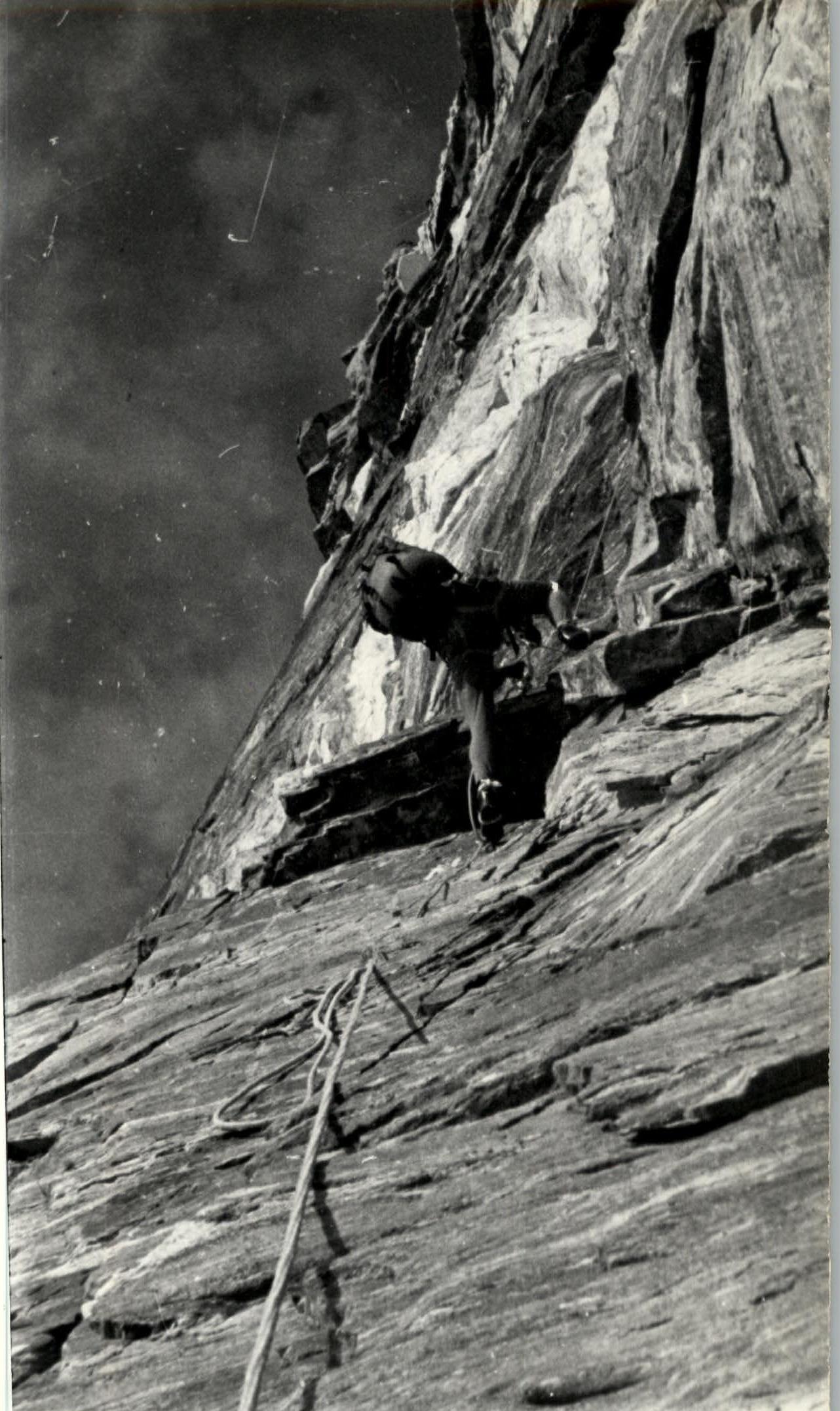
Photo 8 (section R26–R27)