The best mountaineering achievements of 1962 in the category of high-altitude ascents.
Peak Tajikistan Peak «6565» (PAMIR) FIRST ASCENT
Sports team Leningrad Regional Council of the DSO "Burevestnik"
Team captain: Savvon S.M., Master of Sports of the USSR
Coach: Gromov A.G., Master of Sports of the USSR
Leningrad — 1962
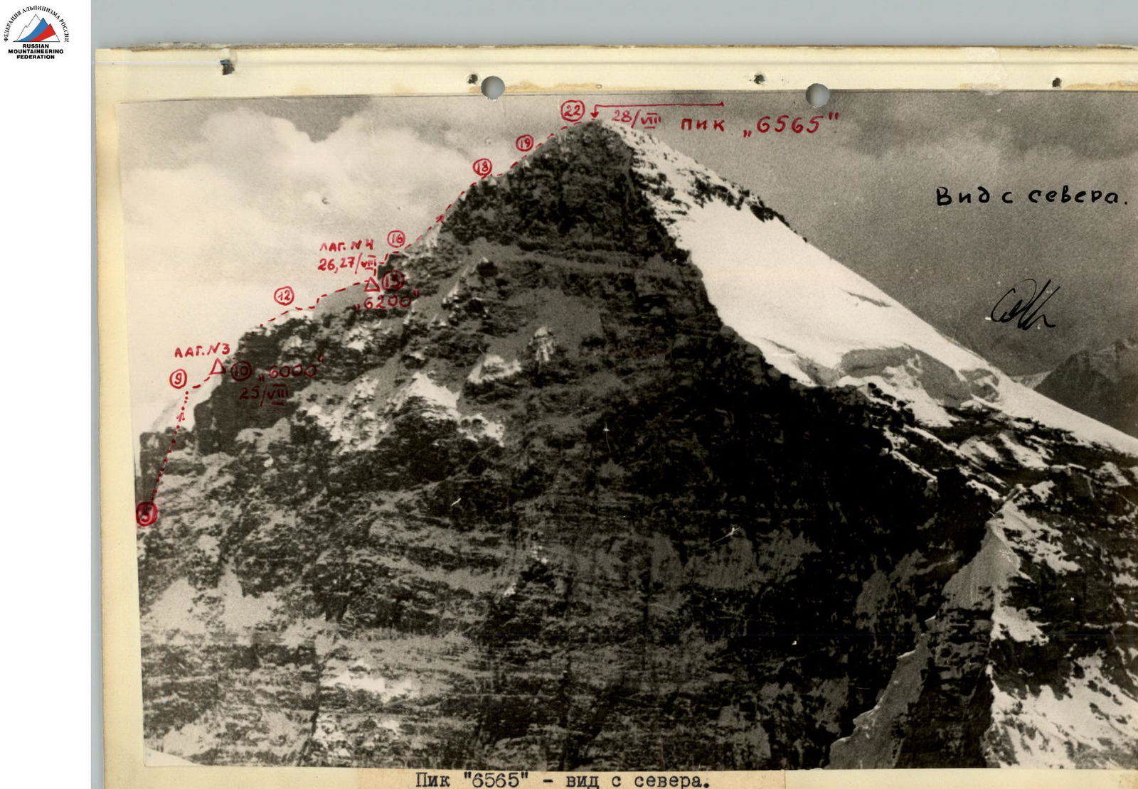

Peak «6565» — view from the southeast.
 (3) — CAMP, the number in the circle indicates the number of overnight stays.
Report
on the ascent of Peak «6565» — Shakhdara Range, Pamir (first ascent)
1. Geographical location and sporting characteristics of Peak «6565»
a) Geography of the region
Peak «6565» is the second highest point in the southwestern Pamir, уступая первое место пику Карла Маркса (6726 м). The grand peak rises above the Pyandzh River valley, 10 km south of the saddle between Peaks Marx and Engels (6510 m).
The Shakhdara Range, also known as the Vakhan Range, in whose southern spur Peak «6565» is located, is the most powerful range in the southwestern Pamir and forms the watershed between the Pyandzh and Shakhdara rivers.
The range stretches almost latitudinally from Peak Mayakovsky to the Mats Pass (in the east), which separates it from the South Alichur Range. To the southwest, the Shakhdara Range borders the Inkashin Range. The range is separated from the Hindu Kush by the Pyandzh River valley. The snow-white wall of the Hindu Kush rises nearby, to the south, opposite the peaks of the Shakhdara Range.
The Shakhdara Range is about 100 km long. It is conditionally divided into western and eastern parts by the Vrang Pass, the upper part of the glacier. The first ascent route is of a combined character. Ice falls alternate with rock walls and steep snowy ascents with cornices and crevasses.
The most convenient point on the Pyandzh River for organizing a transshipment base and a caravan is the village of Vrang, where the Osh — Kharagush — Ishkashim motor road passes. The height of the village of Vrang above sea level is about 2900 m.
b) History of mountaineering development
Before the October Revolution, Russian scientists compiled only an approximate map of the ranges in the southwestern Pamir.
In Soviet times, S. Klunnikov, A. Popov, B. Barkhatov, and others paid attention to the study of the Shakhdara Range. However, the southwestern Pamir was not studied immediately. According to Klunnikov's erroneous data, Peak Marx was considered to be a seven-thousander for a long time.
Only thanks to mountaineering expeditions was it possible to study the orography of the range in detail in this hard-to-reach region.
In 1946, an expedition of the All-Union Central Council of Physical Culture and Sports, led by E. Abalakov, passed through the Shaboia gorge (northern slope) with a caravan and made the first ascent of Peak K. Marx from the north along the western ridge. After the ascent, the group descended along the West Nishgar glacier to the village of Vrang. The expedition did not find real ascent routes to Peaks «6565» and Engels.
In 1954, an expedition of the Georgian Mountaineering Club, led by O. Gigineishvili, worked on the southern slopes of the Shakhdara Range. A group of Georgian climbers, with the participation of Honored Master of Sports K. Kuzmin, ascended Peaks Marx and Engels from the south. The reconnaissance of Peak «6565» did not yield positive results.
In 1958, an expedition of the Moscow City Council of the DOS "Trud" under the leadership of Honored Master of Sports V. Tikhonravov penetrated the previously unvisited West Dirij glacier and made an ascent of Peak «6222», located east of Peak «6565». No attempts were made to ascend Peak «6565».
In 1961, a new route from the east to Peak Marx was traversed by a group of the Leningrad Regional Council of the DSO "Burevestnik" under the leadership of Master of Sports S. Savvon.
Groups of the "Burevestnik" expedition visited the West and East Nishgar glaciers, made a number of ascents and first ascents on the six-thousanders of the region, and conducted reconnaissance of Peak «6565».
In the same year, an expedition of the Central Council of the DOS "Spartak" declared a route to Peak «6565» for the best mountaineering achievements. However, the Spartakovites did not ascend Peak «6565», limiting themselves to ascents of Peak Marx from the west and southwest.
In 1962, a high-altitude mountaineering expedition of the Leningrad Regional Council of the DSO "Burevestnik" again went to the area of the Nishgar and Dirij glaciers. Participating in the ascents for the best mountaineering achievements, our group ascended Peak «6565» from the east. The route was rated as the highest — 5B category of complexity.
The route passes along the Dirij glacier through the lower ice fall to the 5000 m plateau and further along the steep ridge to the peak. The path is technically complex, with sheer ice and rock sections. The rocks on the route are characterized by complexity and fragility (typical for this region).
In many areas, a crust of ice formed on top of the glacial ice, which greatly complicated the passage and belaying. On snowy sections, loose snow made it impossible to belay using an ice axe.
The passage of the rock wall with a large steepness at an altitude of over 6000 m was made possible after preliminary processing and hanging a ladder and lifeline ropes. The wall was processed in boots. A total of 320 m of ropes and a 25-meter ladder were hung on the route (main and auxiliary).
2. Climbing conditions
a) Relief
The Peak «6565» massif is characterized by practically sheer walls, the junctions of which form steep ridges, dropping off in the lower part by walls. The eastern ridge, along which the route passed, has an average steepness of 60°.
The passage of the lower part of the Dirij glacier from an altitude of 4500 m to 5000 m is complicated by an ice fall, which required a lot of time and effort to overcome on the section R7–R8.
A large number of crevasses, alternating with steep sections, required careful marking of the entire glacier. In some areas, lifeline ropes were hung, and passages and steps were cut out.
A large number of hidden crevasses on the 5000 m plateau and above, up to the 5400 m saddle, combined with a shallow snow layer, made it impossible to organize belaying using an ice axe, greatly hindering progress.
The steepness on the section (5000 m — 5400 m) is 45°.
Further, the path goes around the rock wall along ice falls, the steepness of which was from 50° to 70°. When processing this section — from 5400 m to 6000 m — steps and handholds were cut out, and continuous belaying was carried out using ice screws. 160 m of lifelines were hung, after which it became possible to overcome this section with backpacks.
The approach to the rock ascent 6200–6300 m was made along a steep snowy ridge with giant cornices to the north. Loose snow did not allow belaying using an ice axe, as it did not compact. This circumstance greatly complicated the progress. Under the wall, it took about 3 hours to cut out a site for a high-altitude tent.
Almost a full day was spent processing the rock wall. Initially, the wall was about 100 m with an average steepness of 70–80°, with sheer individual and overhanging sections. Three ropes (120 m) and a 30-meter ladder were hung, without which it was impossible to pass the wall with backpacks. The complex rock work was done over the Zugvand glacier, which flowed 2500 m below.
The traverse along the rock ledge above the wall at an altitude of over 6200 m was very technically complex and passed over a sheer drop. It led to a steep 60° snowy slope. Belaying on snow was possible only using paired ski poles. It was necessary to almost wade through the steep loose snow. Cold weather and the presence of ice crust prevented avalanches.
In the upper part of the ascent, a steep firn wall led to a firn fall, breaking the ridge, the passage of which was a serious problem, as the only bridge was unreliable. Much time was spent organizing reliable belaying.
Further, there is a pre-summit ascent with a steepness of 50°, which leads to a broad summit area (a scree site). To the right, there are giant cornices to the north.
A serious technical difficulty of the route is its steepness up to 70° on snowy-ice sections and up to 90° on rocks. The rock wall at an altitude of 6200–6300 m, with an average steepness of 70–80°, has individual overhanging sections.
The ascent, with its steepness and technical complexity at altitudes over 6000 m, is a complex combined ascent of the highest category of difficulty.
The eastern ridge from camp 5400 m.
6. Order of passage of the route
see the route diagram, photographs, and table.
Route
On August 20, from the base camp located on the lateral moraine of the Dirij glacier at an altitude of about 4500 m, the path goes along the heavily crevassed middle part of the Dirij glacier (Dirij glacier ice fall). The glacier is sandwiched between rock walls of the southern spurs of Peaks «6565» and «6222». On the R1 section, the height difference is about 400 m, and the path is replete with a large number of steep ice walls, wide crevasses with arch bridges, and seracs. The ice fall was preliminarily processed and marked during previous exits, but even so, it took 6 hours to overcome it.
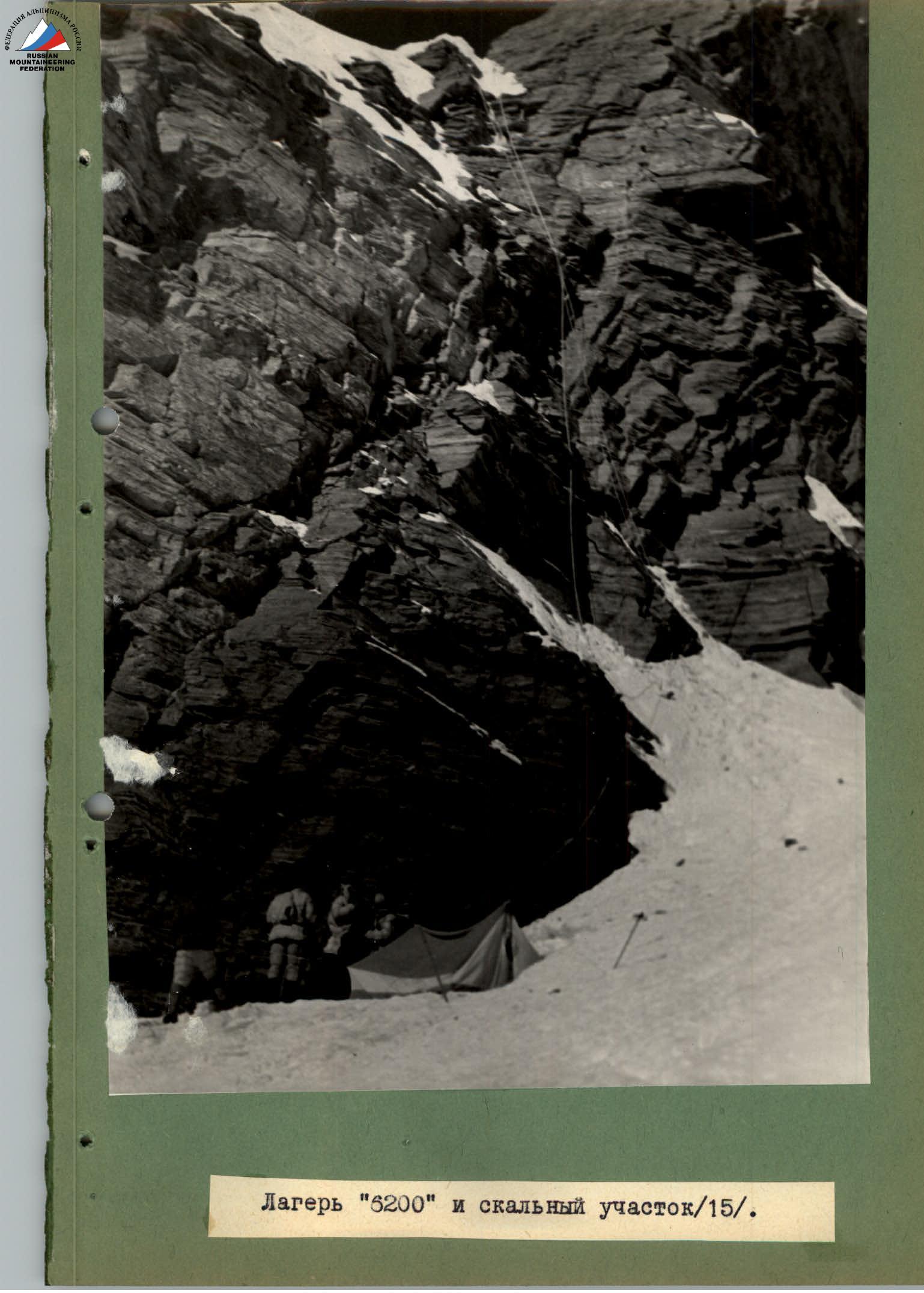
Camp 6200 m and rock section R15.
An attempt to deviate from the ladder on section R15 was unsuccessful (view from above). The steepness of individual walls reached 60°. Movement was on crampons. At the key point, approximately at an altitude of 4700 m, three ice screws were driven for belaying. In many places, it was necessary to cut out steps, as those cut out earlier had melted significantly. Lifeline ropes were left in several areas.
The next section, R2, of the path along the Dirij glacier went along its relatively gentle (20°) middle part — a closed glacier.
A lot of time was spent maneuvering between hidden crevasses (although the path was marked). When moving along snowy areas, careful belaying was done using an ice axe. About two hours were spent on section R2. In total, 8 hours of work were done for the day.
Camp 5000 m above the eastern wall of Peak «6565» on the Dirij glacier plateau. Deep snow. Many hidden crevasses.
August 21. Departure at 9:00. Weather is good. From the plateau, a steep snowy, местами ледовый, склон к перемычке between Peak «6565» and Peak «6222» (R3) begins immediately. The slope steepness is 45°. Movement with careful belaying using an ice axe. Many hidden and open crevasses.
In some areas of the slope, traces of old avalanches are visible, but when moving, it is clear that the snow structure is favorable. In the upper part of the slope, under the rocks, where camp 5400 m is located, ice is encountered on the path. It was necessary to drive two ice screws for belaying. When exiting onto the rocks, a lifeline rope was hung. In total, 6 hours of work were done for the day.

Passage of rock wall R15 along the ladder, 6200–6300 m.
Passage of the upper part of section R15 — view from above.
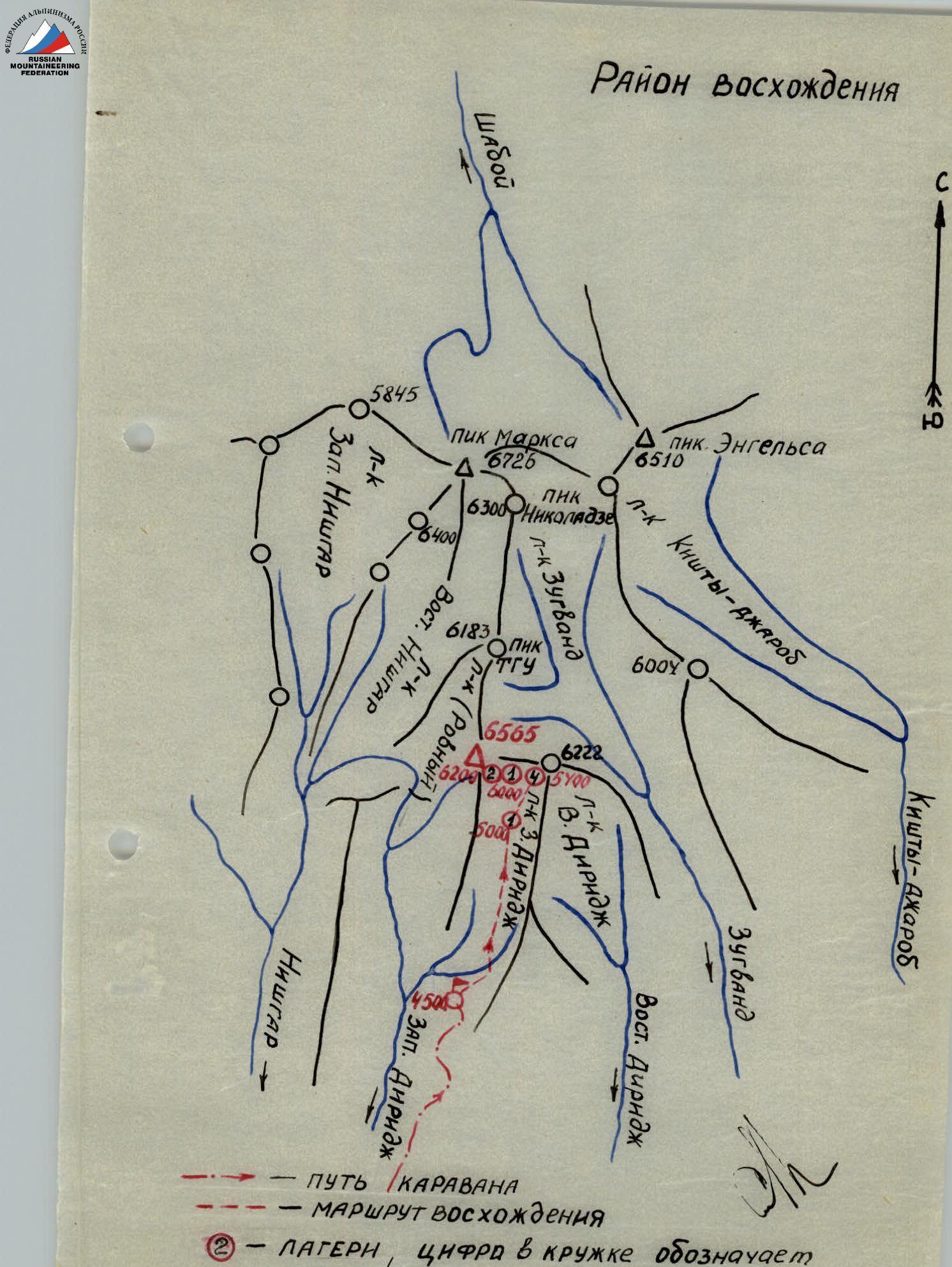
A group of the highest peaks of the range, peaks: Marx, «6565», and Engels — is located in its eastern part, not far from the Vrang Pass. The average height of the range is 5500 m, and in the area of maximum uplift, it reaches 6000 m.
The southern slope of the range drops off to the Pyandzh River with a steep wall, dissected by narrow canyons of streams:
- Nishgar;
- Dirij;
- Zugvand, originating from the glaciers of the same name.
The Peak «6565» massif is bounded from the west by the East Nishgar glacier (upper branch), from the north by the Zugvand glacier, and from the east and south by the West Dirij glacier. Peak «6565» drops off to all these glaciers with walls from 1500 to 2500 m high.
The most grandiose is the northern wall, the eastern edge of which, at the junction with the eastern wall, was chosen for the first ascent route. The choice is explained by the fact that at the junction of the northern and eastern walls of the massif, there is a steep ice-rock ridge, dropping off with a sheer wall to the 5400 m saddle between the «6565» and «6222» massifs.
The path along this ridge is the safest in terms of rockfall, avalanches, and firn collapses. The base camp was located near the Dirij glacier at an altitude of about 4500 m.
The approach to it passes from the village of Vrang along the canyons of Nishgar and Dirij (35 km).
The approach to the 5000 m plateau on the Dirij glacier, from where the most technically complex part of the route begins, passes first along the lower ice fall of the Dirij glacier and then along a relatively gentle (with numerous crevasses) terrain.
An overnight stay on the rocks at an altitude of about 5400 m, where traces of the presence of the "Trud" group, which apparently conducted reconnaissance of Peak «6565» in 1958, were found.
On the night of August 22, it is very warm, complete calm, and it starts snowing. Large flakes slowly fall on the camp. Several times during the night, it is necessary to go outside and clear the tent of snow. In the morning, visibility is zero. By 12:00, the snow stops, but two hours later, snowfall resumes, accompanied by a slight wind. Visibility is still zero. In the evening, it becomes somewhat colder, and the snowfall stops.
On the night of August 23, the wind strengthens. Several times during the night, it is possible to see stars. In the morning, there is no snowfall, but visibility is poor. A avalanche descends from the saddle near the camp. Avalanches go down the gullies of the eastern wall of Peak «6565». In the evening, it becomes very cold. Checking the snow on section R4 gives good results.
On the night of August 24, it is very cold. The sky is clear. We decide to conduct reconnaissance in the morning and, if snow conditions are favorable, process the steep ice wall above the saddle. The departure for processing is made by two teams. About 200 m of ropes are taken, which are supposed to be left on the processed sections.
Immediately from the rocks of camp 5400 m, there is an exit to a steep ice slope. It is very cold. Wind. The steepness of the snowy slope is 45–50°. Movement is in crampons with spikes. The front spikes are shortened. The slope is traversed in the direction of a rock pillar on the saddle. Before the rocks, the slope becomes icy — an ice screw is driven for belaying. Further along the saddle, almost without gaining height — section R5 to the eastern wall of Peak «6565», ориентируясь на скальную стену (кант стены).
A steep ridge of the eastern wall descends to the saddle. Behind the ridge, there is a bend towards the northern wall. The path along the saddle is relatively simple, with deep snow and cornices to the north. From the saddle upwards, there is immediately very steep ice, bounded on the right (from the north) by sheer rocks and on the left by ice falls.
The pair Soustin — Zarichnyak goes ahead. Immediately, there is cutting of steps and belaying on ice screws. Despite the fact that the backpacks contain only ropes for lifelines and a reserve of ice screws, movement is very slow. It is necessary to cut out steps, cut out handholds, and in some places drive ice screws to create additional points of support.
Processing 40 m of the ice wall R6 takes 3 hours. A lifeline rope is left, and the front team goes to process section R7 — a steep ice slope (50°) with crevasses and individual steps (2–3 m), the steepness of which reaches 60°.
For passage, steps, handholds, and ice screws are used for belaying and as additional points of support.
It takes 5 hours to pass three ropes. Leaving lifeline ropes, the group of four descends to the saddle and further to camp 5400 m. Processing sections R4, R5, R6, and R7 takes 9 hours. Eleven ice screws were driven. We return to camp 5400 m in the evening. It is cold. Quite a strong wind.
On August 25, we decide to depart for the route earlier (8:00), as a difficult day is ahead. We quickly overcome sections R4 and R5. Before the lifelines of section R6, there is a short rest, as now it is necessary to move along a very steep ice slope with heavy backpacks. The processing of the wall the day before allows the entire group (6 people) to overcome section R6 (40 m steepness up to 70°) in 2 hours.
Section R7 is also passed by the entire group in 2 hours. All the time, we carefully belay those moving along the lifelines on ice screws. The lifelines are fixed on paired ice screws, as in case of a fall, it is impossible to stop: the steep ice drops off almost sheer to the 5000 m plateau.
The exhausting work on the lifelines with heavy backpacks comes to an end. Now, the group faces an unprocessed section of the route, R8 — a steep snowy slope (45–50°) with numerous crevasses. Careful belaying is necessary, but it is difficult to organize, as the loose and deep snow does not compact. It takes a long time to trample a platform to use an ice axe for belaying. But in some places, this cannot be done, and belaying is done using paired ski poles, which sink into the snow up to the rings. This method was successfully used by the group in many sections of the route, both during ascent and descent. On the descent, sports descents were organized on paired ski poles when passing steep snowy walls. Section R8 turns into a snowy wall — section R9 with a steepness of up to 60°. 40 m of this section, with belaying on paired ski poles, was overcome in 1 hour of hard work in deep snow. The cut leads to a snowy ridge with denser snow (45°).
In some places, there is a crust of ice on the snow. To the right, there are cornices. Belaying is done using an ice axe. The ridge leads to a bergschrund. In total, more than 10 hours of work were done for the day. A platform for camp 6000 m is processed in the steep snowy slope.
On August 26, we depart around 11:00, as the previous day was very difficult. Immediately, it is necessary to start overcoming the bergschrund along a steep snowy bridge with a large steepness (up to 50°). The group spends almost an hour passing 10 m in height (R11).
Finally, we exit onto a snowy slope R12 with a steepness of 40–45°. The snow seems more unstable than on the steeper sections passed earlier. We move cautiously, strictly upwards, with careful belaying using an ice axe. The slope leads to a ridge overhanging to the north with giant cornices. Along the edge of the cornices, we traverse this section R13 in the direction of the rock wall rising ahead. Under the wall, the strong wind is felt less. Although we worked for only about 5 hours, we decide to set up a camp, as the rock wall stands like a ten-meter bastion, blocking further progress. For three hours, we cut out a platform for a high-altitude tent in the steep ice slope under the wall. Belaying is organized on rock screws driven into the lower part of the wall and on ice screws. We decide to dedicate the next day to processing the rock wall above camp 6200 m.
On August 27, processing of the wall by the pairs Soustin — Zarichnyak and Savvon — Rukii begins rather late, as it is very cold and a strong wind does not subside. From camp 6200 m, along the rocks R14, lifelines are organized to the section of the wall where it is planned to begin its passage.
The rocks are very steep (R15). Immediately, it is necessary to drive a rock screw, followed by five more. It takes 4 hours to pass 25 m of the sheer rock wall R15. The first (Soustin) removes crampons and puts on mountaineering boots. Climbing is done in gloves, with warming hands in down mittens. For 8 hours of work on complex rocks with an overhanging section, 80 m of rope and a 25-meter ladder are hung. The rock in the upper part is more destroyed. The steepness of the rocks in this section R16 is about 70°. 6 screws are driven on 40 m. In total, 14 rock screws are driven for the day. Descent to camp 6200 m.
On August 28, it is decided to launch a штурм the peak. Therefore, the departure is early for such an altitude — at 7:00. We approach the lifelines R14 along a ladder hanging from a ledge next to the lifelines fixed on a rope. Now, when moving in crampons, ascent without a ladder and lifeline rope is practically impossible. Especially difficult is the place where the ladder hangs sheer from the ledge where the rocks overhang.
The first passes this section without a backpack, the rest — with lightened backpacks. It takes almost two hours for the group to pass this section. Hands freeze strongly, both during climbing and belaying. After the ladder, there is a transfer to new lifelines R16 — leading to the upper part of the southeastern wall. This is another 1.5–2 hours of hard work on steep (70°) rocks at an altitude of about 6300 m in strong winds.
Further, the path is not processed. The snowy ledge R17 with snow steeply descends to a snowy slope. It is necessary to move extremely cautiously, using piton hooks for belaying, practically without gaining height. In some places, the ledge is icy.
The ledge leads to a snowy ridge with cornices (to the north). The ridge is traversed R18 below the line of their break-off along a steep snowy slope. The higher, the steeper the ridge becomes, ending in a snowy wall with a steepness of about 60°. Belaying is done only using paired ski poles.
On the section of the snowy wall, lifelines are organized (for descent), fixed on paired ski poles. The ridge becomes gentler (45°). The snow is denser. Belaying is possible using an ice axe. Many hidden crevasses. Especially many under the wall of the firn fall R20. It takes about an hour to overcome this obstacle. The altitude begins to take its toll. The path goes along a rock outcrop. Traverse belaying is done using an ice axe. After the fall, along the ridge with a steepness of 45° (R21), with comparatively dense, wind-compacted snow, the path goes to a bend, behind which the summit should be. Rock outcrops. To the right, there are cornices. Belaying is done using an ice axe. The ridge turns into a gentle snowy dome with areas of destroyed rocks.
The summit of Peak «6565». From camp 6200 m to the summit, about 9 hours of work. A large cairn is built in the western part of the summit area. After spending 30 minutes on the summit and taking a circular panorama, we begin the descent to camp 6200 m. Using lifelines and a ladder, we reach the tent in 3.5 hours.
On August 29, we descend along the ascent route to camp 6000 m and, without lingering there, use lifelines to go to the saddle and camp 5000 m, where we are met by the auxiliary group.
On August 30, together with the auxiliary group, we descend to the base camp.
On September 2, having descended from the base camp with a caravan of donkeys, all participants of the expedition departed by car to the city of Khorog.
There were no significant deviations from the pre-planned route. The first ascent route is very interesting, of a combined character. From camp 5000 m and above, it is technically extremely difficult. Characterized by steep ice, snow, and rock sections.
Great difficulty was presented by the passage of the rock wall at an altitude of about 6300 m, which had sheer and overhanging sections.
The group evaluates the route as complex, 5B–6B category of complexity.
Additional data on the route
The ascent route to Peak «6565» is a technically complex high-altitude route of a combined character. On the route, sections with a steepness of 45–60° alternate with rock and ice sections of 70–80°. At an altitude of 6200–6300 m, a sheer rock wall with an overhanging section was overcome. The passage of this wall, as well as the first ice ascent, required preliminary processing.
The passage of ice sections was complicated by the presence of a layer of snow even on very steep sections. On snowy sections of the route, at altitudes above 5500 m, loose snow did not allow ensuring belaying using an ice axe, as the snow did not compact.
Belaying in these cases was done using paired ski poles.
Weather conditions on the route were satisfactory (two days of waiting), although usually in this region, the weather is much better.
The first ascent route to Peak «6565» is technically complex and is a difficult route of 5B–6B category of complexity.
Team captain, Master of Sports
 (S. M. Savvon)
| Date | Continuation | Average steepness | Height gain | Characteristics of sections and conditions of their passage | Time | Driven in hooks | Camping conditions | Weight of daily ration per person. |
|---|---|---|---|---|---|---|---|---|
| By relief character | By technical difficulty. | By belaying method. | Exits | Stops at bivouacs | ||||
| 1 | 2 | 3 | 4 | 5 | 6 | 7 | 8 | 9 |
| August 20 | R1 | 30°, местами стенки до 60° | 400 m | Ice fall of Dirij glacier. | 4A | Alternating, three ice screws, sometimes simultaneous. | Good | 1000 g |
| R2 | 20° | 100 m | Closed glacier. | Good. | ||||
| August 21 | R3 | 45° | 400 m | Steep, snowy, местами ледовый склон | 4A | Alternating, sometimes simultaneous | Good, warming. | 900 g |
| August 22 | Waiting | In camp 5400 m, heavy snowfall, zero visibility. | 800 g | |||||
| August 23 | Waiting | In camp 5400 m, as although the weather has improved somewhat, but the snow is very unstable. | 1000 g | |||||
| Reconnaissance of section R4, visibility is poor. | ||||||||
| August 24 | R4–R7 | Processing by two teams (4 people) of sections R4, R5, R6, and R7 | Clear weather, cold, wind | |||||
| 1 | 2 | 3 | 4 | 5 | 6 | 7 | 8 | 9 |
| August 25 | R4 | Traverse of slope with steepness 45–50° with exit to saddle. | 50 m | Steep snowy, местами ледовый склон. | 4А–4Б | Alternating through ice axe and through screw. | Good | 800 g |
| R5 | Traverse | 30 m | Snowy saddle, deep snow. | Alternating through ice axe. | Good. | |||
| R6 | до 70° | 40 m | Ice wall between sheer rocks and ice falls. | 5А–5Б | Belaying through ice screws, steps, and handholds. Lifelines are left for descent. | Good. | ||
| R7 | 50° steps by 2–3 m up to 60° | 100 m | Steep ice with crevasses. | 5Б | Belaying through ice screws. Lifelines are left for descent. | Good. | partly doubled. | |
| R8 | 45–50° | ок. 150 m | Steep snowy slope with crevasses | 5А | Belaying through ice axe and through paired ski poles. | Good. | ||
| R9 | до 60° | 40 m | Snowy wall. | 5Б | Belaying through paired ski poles. | Good. | ||
| R10 | 45° | 200 m | Traverse of snowy, местами покрытого ледяным настом гребня, cornices. | 4Б | Belaying through ice axe. | Good. | 800 g | |
| August 26 | R11 | 45–50° | 10 m | Overcoming bergschrund along a steep snowy bridge. | 4Б | Through ice axe. | Strong wind II–III | |
| 1 | 2 | 3 | 4 | 5 | 6 | 7 | 8 | 9 |
| August 27 | R12 | 40° | 40 m | Steep snowy slope, bounded on the right by rocks. | 4Б | Through ice axe. | Strong wind | |
| R13 | 45° | 150 m | Traverse of snowy ridge with large cornices. | Through ice axe. | 800 g | |||
| August 27 | Processing of sections R14, R15, and R16 of the rock wall. | 80 m of main rope and 25 m of ladder are hung. Strong wind. | ||||||
| August 28 | R14 | 45° | ок. 7 m | Snowy ridge. | Belaying on lifelines along rocks. | |||
| R15 | до 90° with an overhanging section | 25–30 m | Rock wall. | 5Б | Lifelines and rope ladder, part of the screws driven during processing is knocked out. Very difficult climbing. | Good. | ||
| R16 | 70° | 40 m | Rock wall. | 5А–5Б | Lifeline rope. Alternating belaying through screws. | Strong wind | ||
| 1 | 2 | 3 | 4 | 5 | 6 | 7 | 8 | 9 |
| August 28 | R17 | 40° | 3 m | Rock ledge with snow, местами лёд. | 5А–5Б | Belaying only through a rock screw. | Strong wind. | |
| R18 | до 60° | 120 m | Steep snowy ridge with cornices | 5Б | Belaying only through paired ski poles. Lifelines — 40 m. | Wind | ||
| R19 | 45° | 80 m | Snowy ridge with cornices and crevasses. | 5А | Through ice axe. | Wind | ||
| R20 | 50° | ок. 15 m | Wall of firn fall, crevasses, along a rock outcrop. | 5Б | Through ice axe. | Wind | ||
| R21 | 50° | ок. 80 m | Steep snowy ridge with rock outcrops. Belaying through ice axe. To the right, cornices. | 5А–5Б | Through ice axe. | |||
| R22 | 20° | 10 m | Gentle snowy dome with patches of destroyed rocks. Summit is scree. There are rock outcrops. | Simultaneous movement. | ||||
| Descent to camp 6200 m. On sections R15 and R16, descents are made by rope. Overnight stay in camp 6200 m. | 800 g | |||||||
| August 29 | Descent to camp 5000 m. | Overnight stay in camp 5000 m. | 1000 g | |||||
| August 30 | Descent to base camp. |
Team captain — (S. Savvon) Team coach: (A. Gromov)