
Ascent Passport
I. Ascent class: High-altitude technical 2. Ascent area: Southwestern Pamir 3. Peak, its height, and ascent route: peak 5739 (Moskovskaya olimpiada, northeastern wall) 4. Estimated difficulty category: 6 5. Route characteristics:
- Height difference: 1003 m
- Average steepness: 74° (Bastions)
- Average steepness of the wall:
- 79°
- 84°
- 80°
- Length of sections:
- 25 m
- 168 m
- 454 m
- 470 m
- Pits driven:
- for belaying: rock 245, ice 19, bolt 6
- for creating ITO: rock 21, ice 2
- Number of travel hours: 56.5 h + 24 h processing
- Number of bivouacs and their characteristics: 5 bivouacs (3 good, 2 satisfactory)
- Surname, name, patronymic of the leader and participants, their sports qualification:
- Kurgin S.N. — team captain, Master of Sports
- Prokopenko V.I., Master of Sports
- Ryzhov G.I., Master of Sports
- Korenkov Yu.N., Candidate for Master of Sports
- Izmailov V.N., Candidate for Master of Sports
- Sokolov G.A., Candidate for Master of Sports
- Team coach — Kurgin S.N.
- Date of departure and return: 29.07.1979; 05.08.1979

- Ascent route to peak 5739
Description
of the route to peak 5739 («Moskovskoy Olimpiady») via the center of the northeastern wall, 6th category of difficulty (approximately). First ascent.
From the base camp near the second kosh:
- along the right orographic side of the Dzhiraf river to the glacier moraine;
- then along the right orographic part of the moraine along the stream to the glacier;
- across the glacier to the left corner of the cirque under the northeastern wall of peak 5739, where the assault camp is set up.
The approach to the wall from the base camp takes 7 h. From the assault camp, a snowy-icy ascent (steepness 20–45°, with hook belays on steep sections) leads to a snow-filled depression under the wall.
The route begins from the snow-filled depression, going upward to the right (15 m, 60°) under the bergschrund. Up the icy wall of the bergschrund (10 m, 90°) to the icy slope, and then under the rocks (20 m, 35°). Traverse right along the rocks on ice to a clearly defined rocky shoulder (25 m). On the rocky shoulder is the first control point.
From the rocky shoulder upward under the cornice (15 m, 70°), which is bypassed on the left via an internal corner (10 m, 85°); the rocks are fragile, and climbing is difficult. Up the wall, composed of blocks (25 m, 75°). The cracks are filled with ice, the rocks are wet, and climbing is complex.
Exit onto stepped, destroyed rocks, where the climb under the smooth black wall is cautious (45 m, 60°).
Up the black, smoothed wall to the left, into an internal corner with ice, where holds are small and there are no cracks (20 m, 75°). The internal corner is climbed using chimney technique. Climbing is extremely difficult (10 m, 90°). Exit onto a small narrow platform for two people.
Traverse left along a ledge for 5 m.
Then upward via sandy-structured rocks to a "tooth" under a cornice, where there are no cracks, and climbing is extremely difficult (25 m, 80°).
Traverse under the cornice to the right, to a red slab, 6 m.
The cornice is climbed head-on, with extremely difficult climbing using artificial holds (5 m, 120°).
Exit onto a smoothed wall without holds, straight up to a wide horizontal crack (25 m, 80°), with extremely difficult climbing.
Traverse along the crack to the right for 3 m.
Up the wall via a vaguely defined groove, where the rocks are smoothed, and climbing is extreme (20 m, 80°).
Exit onto a small, scree-covered ledge, behind which begins an icy belt.
Via destroyed rocks to the icy belt (10 m, 60°).
Backpacks are pulled up. A bivouac site.
From the bivouac, up the icy slope to destroyed rocks (60 m, 55°).
Up the rocks straight to a vaguely defined internal corner (15 m, 60°). Traverse left and up via slabs and ledges (30 m, 70°) toward a white belt. Then up the wall, with very difficult climbing, few holds, and exit onto a ledge where two people can gather. Backpacks are pulled up (70 m, 80°). From the ledge straight up through a system of cornices to the second snowy belt, with extreme climbing and cornices climbed head-on (75 m, 90–100°). Backpacks are pulled up. Bivouac at the junction of ice and rocks. Second control point.
From the bivouac, up a vaguely defined snowy ridge to the "Korablik" bastion, with high, loose, deep snow that is difficult to traverse (80 m, 50°) — in the middle of the snowfield is a rocky outcrop where hooks can be driven. From the start of the bastion, a complex traverse left via "ram's foreheads" covered in ice, 10 m.
Then through "ram's foreheads" (30 m, 60°) to a gray corner, with ice and no place to drive hooks. Up the corner (20 m, 90°) to the exit of a counterfort, 20 m along the counterfort to the top of the "Korablik" bastion (85°). Along a very sharp, steep icy ridge to the base of the summit tower. Under the rocks is a sitting bivouac (40 m, 60°).
From the bivouac upward via gray rocks through four cornices, with extreme climbing and cornices climbed using ladders and chocks, to a ledge (80 m, 90°). On the ledge, backpacks can be received. Along the ledge, traverse right 3 m to a corner into a groove filled with ice. Up the left part of the groove (30 m, 70°) under its overhanging part. Along it, 10 m of extreme climbing (100°) using ladders, with a transition to the right part of the groove. Then up it (35 m, 85°) to a small narrow ledge, with extreme climbing and ice. On the ledge is the 3rd control point.
From the ledge upward along the edge of the groove via "tile-like" rocks, with difficult climbing (80 m, 80°) to a ledge. Bivouac.
From the bivouac (20 m, 65°) upward, with difficult climbing, exit onto the summit tower and then along the left ascent (40 m, 45°) to the summit.
Descent along the southern ridge for 300 m to the junction of the ridges, then across snowy fields to the east for 500 m, and then across the glacier to the right along the route to the moraine.
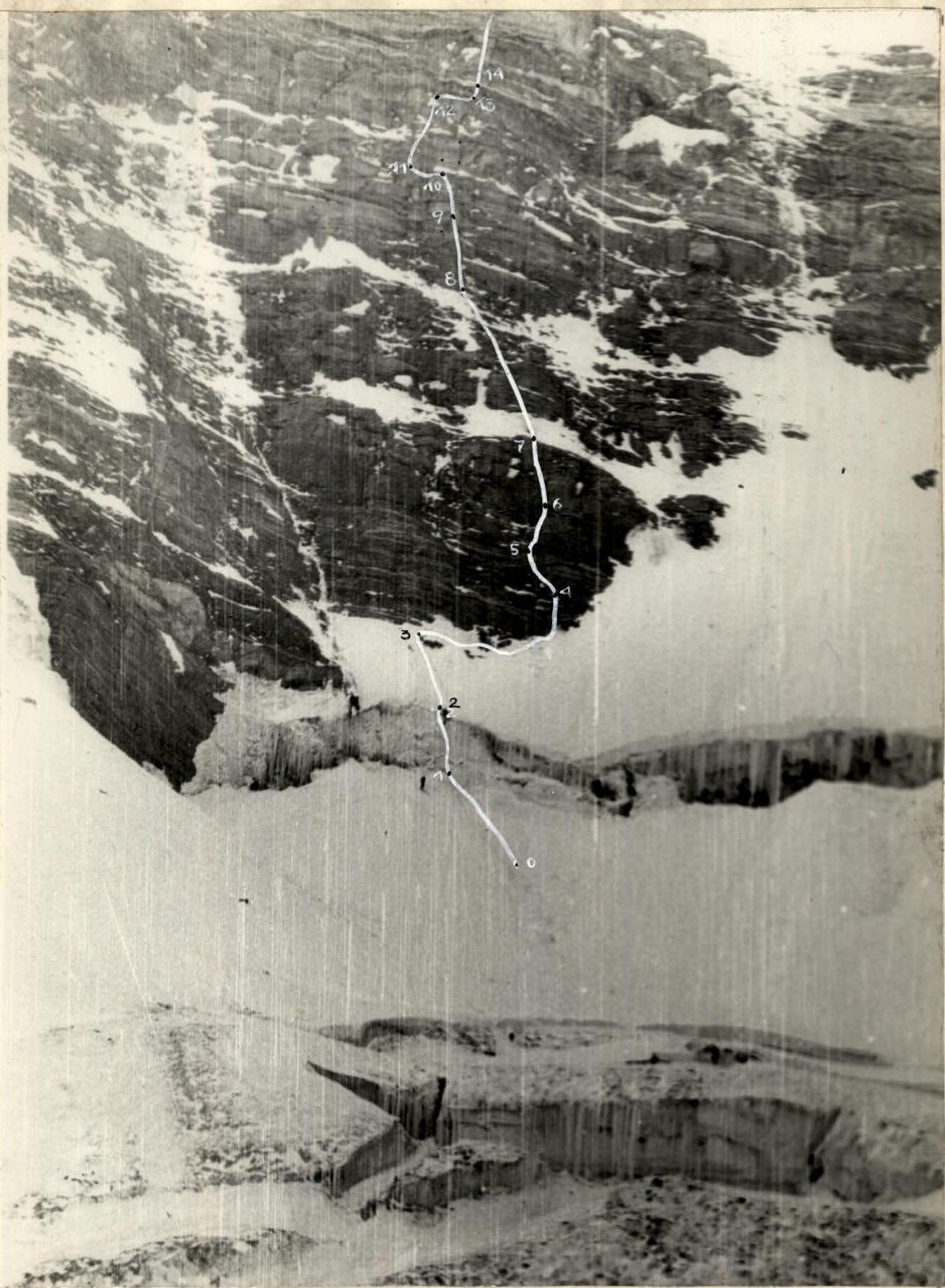 2. Lower part of the route
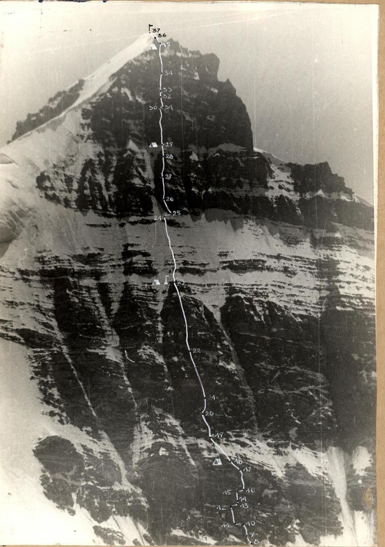 3. Upper part of the route
Table of main route characteristics
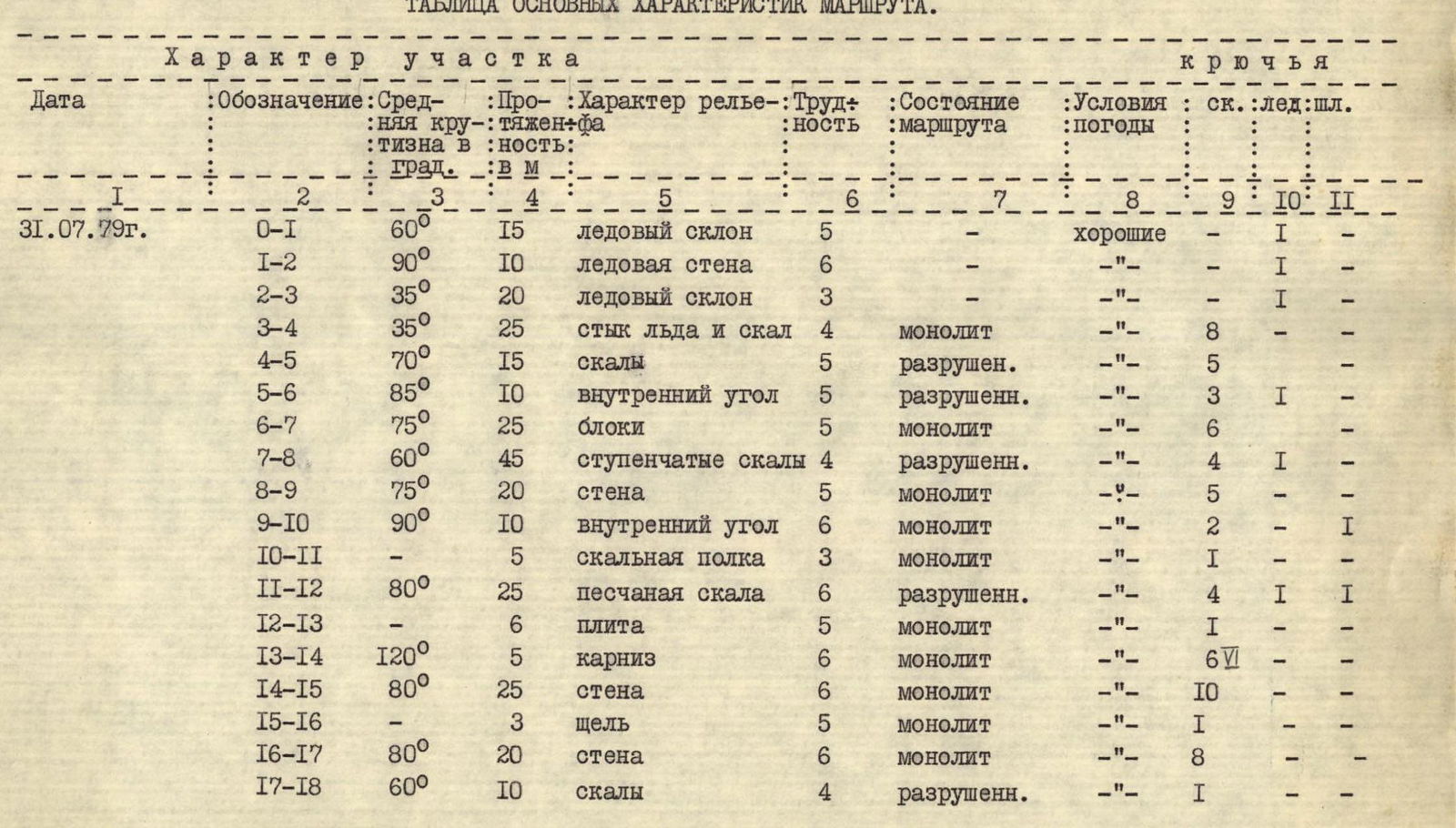
| Date | Designation | Average steepness in ° | Length in m | Terrain characteristics | Difficulty | Route condition | Weather conditions | rock | ice | bolt |
|---|---|---|---|---|---|---|---|---|---|---|
| 31.07.1979 | R0–R1 | 60 | 15 | icy slope | 5 | good | 1 | – | – | |
| R1–R2 | 90 | 10 | icy wall | 6 | – | «–» | 1 | – | – | |
| R2–R3 | 35 | 20 | icy slope | 3 | – | «–» | 1 | – | – | |
| R3–R4 | 35 | 25 | junction of ice and rocks | 4 | monolithic | «–» | 8 | – | – | |
| R4–R5 | 70 | 15 | rocks | 5 | destroyed | «–» | 5 | – | – | |
| R5–R6 | 85 | 10 | internal corner | 5 | destroyed | «–» | 3 | 1 | – | |
| R6–R7 | 75 | 25 | blocks | 5 | monolithic | «–» | 6 | – | – | |
| R7–R8 | 60 | 45 | stepped rocks | 4 | destroyed | «–» | 4 | 1 | – | |
| R8–R9 | 75 | 20 | wall | 5 | monolithic | «–» | 5 | – | – | |
| R9–R10 | 90 | 10 | internal corner | 6 | monolithic | «–» | 2 | – | 1 | |
| R10–R11 | – | 5 | rocky ledge | 3 | monolithic | «–» | 1 | – | – | |
| R11–R12 | 80 | 25 | sandy rock | 6 | destroyed | «–» | 4 | 1 | 1 | |
| R12–R13 | – | 6 | slab | 5 | monolithic | «–» | 1 | – | – | |
| R13–R14 | 120 | 5 | cornice | 6 | monolithic | «–» | 6 | – | – | |
| R14–R15 | 80 | 25 | wall | 6 | monolithic | «–» | 10 | – | – | |
| R15–R16 | – | 3 | crack | 5 | monolithic | «–» | 1 | – | – | |
| R16–R17 | 80 | 20 | wall | 6 | monolithic | «–» | 8 | – | – | |
| R17–R18 | 60 | 10 | rocks | 4 | destroyed | «–» | 1 | – | – | |
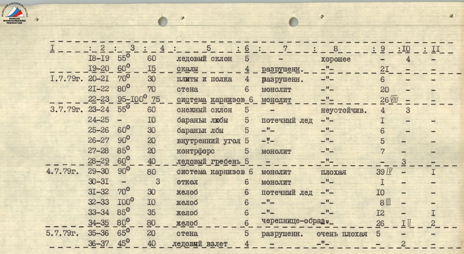
| 01.07.1979 | R18–R19 | 55 | 60 | icy slope | 5 | good | 4 | – | – | |
| R19–R20 | 60 | 15 | rocks | 4 | destroyed | «–» | 21 | – | – | |
| R20–R21 | 70 | 30 | slabs and ledges | 4 | destroyed | «–» | 6 | – | – | |
| R21–R22 | 80 | 70 | wall | 6 | monolithic | «–» | 20 | – | – | |
| R22–R23 | 95–100 | 75 | system of cornices | 6 | monolithic | «–» | 26 | – | – | |
| 03.07.1979 | R23–R24 | 55 | 60 | snowy slope | 5 | unstable | 4 | – | 3 | |
| R24–R25 | – | 10 | "ram's foreheads" | 5 | flowed ice | «–» | 1 | – | – | |
| R25–R26 | 60 | 30 | "ram's foreheads" | 5 | «–» | «–» | 6 | – | – | |
| R26–R27 | 90 | 20 | internal corner | 5 | «–» | «–» | 5 | – | – | |
| R27–R28 | 85 | 20 | counterfort | 5 | monolithic | «–» | 7 | – | – | |
| R28–R29 | 60 | 40 | icy ridge | 5 | «–» | – | – | 3 | ||
| 04.07.1979 | R29–R30 | 90 | 80 | system of cornices | 6 | monolithic | bad | 39 | – | 1 |
| R30–R31 | – | 3 | ledge | 6 | monolithic | «–» | 1 | – | – | |
| R31–R32 | 70 | 30 | groove | 6 | flowed ice | «–» | 10 | – | – | |
| R32–R33 | 100 | 10 | groove | 6 | «–» | «–» | 8 | – | – | |
| R33–R34 | 85 | 35 | groove | 6 | «–» | «–» | 12 | – | 1 | |
| R34–R35 | 80 | 80 | groove | 6 | tile-like, destroyed | «–» | 26 | 1 | 2 | |
| 05.07.1979 | R35–R36 | 65 | 20 | wall | 5 | destroyed | very bad | 5 | – | – |
| R36–R37 | 45 | 40 | icy ascent | 4 | «–» | – | – | 2 |