
II. Passport
-
High-altitude class, combined route.
-
South-Western Pamir.
-
Peak Marx via the right part of the S wall.
-
5B cat. dif., First ascent.
-
Height difference 1726 m. Average steepness of the wall section — 65°. Length of sections with 5 cat. dif. — 840 m. 6 cat. dif. — 140 m.
-
Pitons driven: | Rock | Nuts | Bolt | Ice | | :------- | :------- | :--------- | :------ | | 27 | 77/7 | 7/7 | 59 |
-
Travel hours during ascent 56.5. Days: 6 during descent 7
-
Overnights: 1st and 2nd — in a suspended platform-tent and on a ledge (2 people) in a mini-tent. 3rd — in a set platform-tent and in a mini-tent (2 people) 4th — in a snow-rock cave. 5th — sitting in a set platform. 6th — in a set platform.
-
Captain: Boyko Valery Viktorovich Master of Sports Participants:
- Martynov Leonid Borisovich Candidate for Master of Sports
- Shuvalov Sergey Vladimirovich Candidate for Master of Sports
- Lebedev Mikhail Vitalievich Candidate for Master of Sports
- Kogan Iosif Meerovich Candidate for Master of Sports
- Pavlova Irina Sergeevna Candidate for Master of Sports
-
Coach: Korsun Anatoly Grigorievich Master of Sports
-
Departure to the route August 16, 1976. Summit August 21, 1976. Return August 22, 1976.
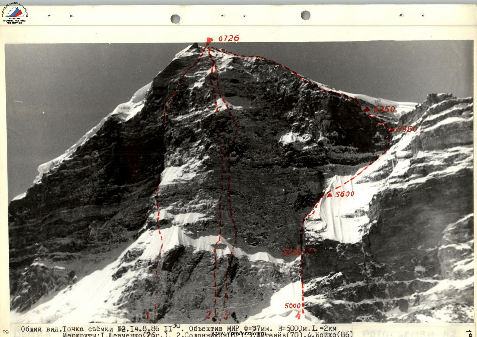 General view. Shooting point #2. August 14, 1986, 11:50. Lens MIR F=37 mm. H=5000 m, L=2 km.

| № | Route | Category of difficulty | Year |
|---|---|---|---|
| 1 | Shevchenko | 6 cat. dif. | 1976 |
| 2 | Solonnikov | 6 cat. dif. | 1982 |
| 3 | Zhitenev | 6 cat. dif. | 1970 |
| 4 | Boyko | 5B cat. dif. | 1986 |
| August 15, 1986, 10:00. Lens MIR f=37 mm. H=4900 m, L=2 km. | |||
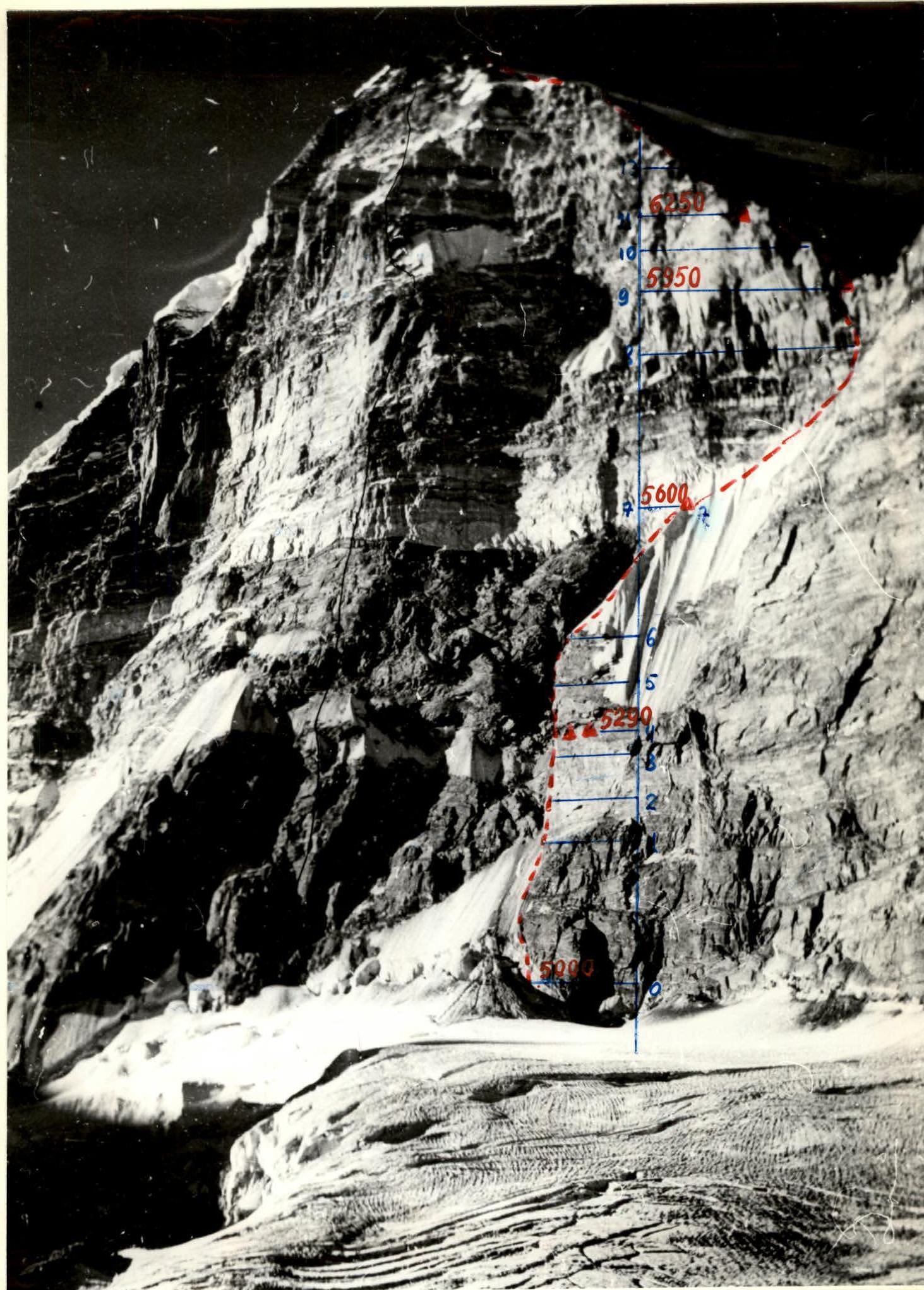 |
View from the RIGHT. Shooting point #3. Photo 1982 (Solonnikov's team). H=4800 m, L=2 km. Approximately from the same point, a technical photo was taken in 1986, p. 10.
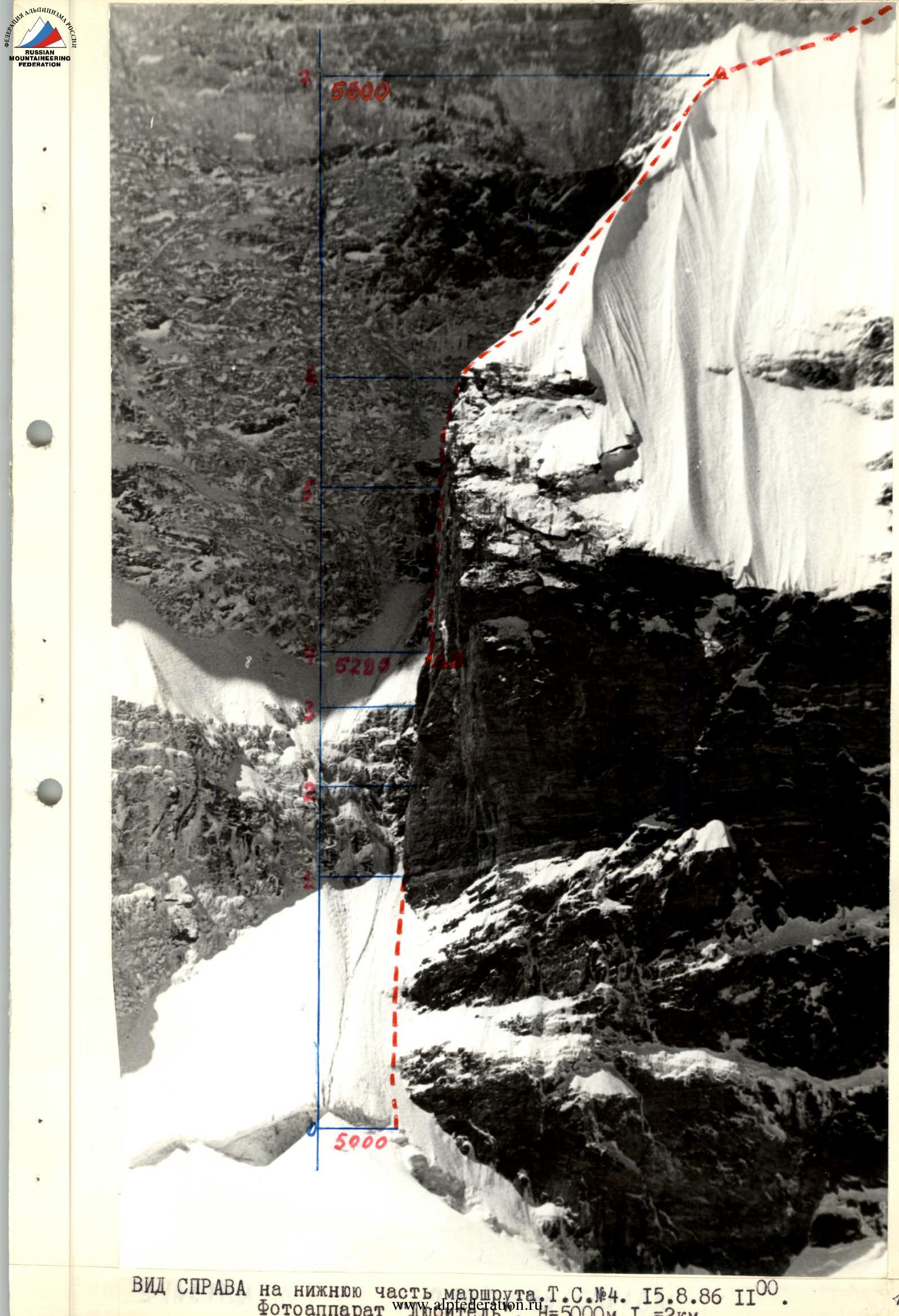
View from the RIGHT on the lower part of the route. Shooting point #4. August 15, 1986, 11:00.
Tactical actions of the team
The tactical plan provided for completing the route in 6 days. Two alternative route options were planned:
- in case of bad weather
- in case of poor condition of the flowstone on the wall
The option with an exit to the NW ridge from under the marble belt to the right was implemented, which was planned for bad weather. 5 overnight stays were made during the ascent and one during the descent.
Organization and change of rope teams, change of leaders: there were no rope teams as such on the wall section of the route. The first and last were appointed, the rest moved as they were ready. The first to work on the sections were:
- 1st — Kogan
- 2nd — Boyko
- 3rd, 4th — Martynov
- 5th — Martynov and Lebedev
- 6th — Martynov
- 7th — Boyko
- 8th, 9th — Lebedev
- 10th — Shuvalov and Boyko
- 11th — Boyko
- 12th — Boyko, Kogan
- 13th — all in turn
Thus, everyone except Pavlova worked as leaders, and the change of leader was carried out 1-2 times a day, depending on the terrain and situation.
Preliminary processing:
- section 5 entirely. After the 1st overnight stay, we spent several hours on reconnaissance of the path through the crevice going up to the left, but due to the great objective danger (after being lit by the sun, stones and ice began to fall), we had to retreat. After Martynov and Lebedev passed the 5th section, it was already too late for everyone to move, and thus a processing day was obtained.
- 1 rope above the 5th overnight stay.
Perils were organized on all sections except R13, R14. The first one went on a double rope, the next ones — along the perils with top insurance. Backpacks were lifted on themselves. Sometimes the first one was given a small backpack, which was occasionally transported by others, tied to a rope.
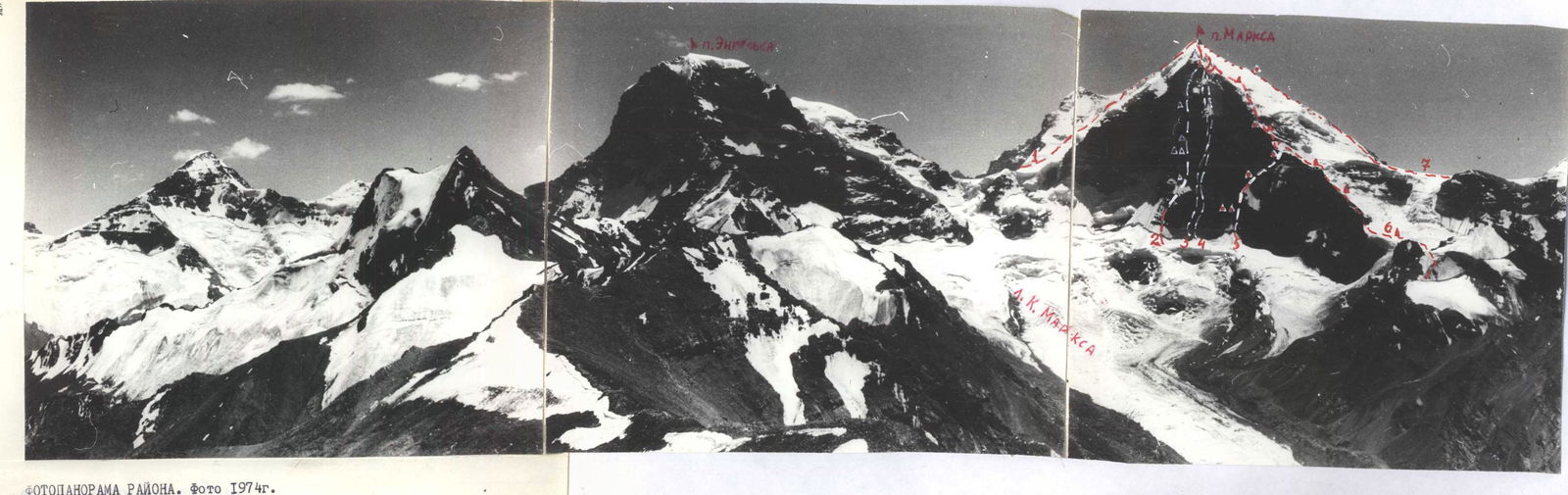
PHOTOPANORAMA OF THE AREA. Photo 1974. Routes to Peak Marx:
-
- (5A cat. dif.)
-
- Shevchenko (6B cat. dif.)
-
- Solonnikov (6 cat. dif.)
-
- Zhitenev (6 cat. dif.)
-
- Boyko (First Ascent)
-
- Prudnikov (5B cat. dif.)
-
- E. Abalakov (4B cat. dif.)
The mode of movement was determined by the northern exposure (rather late exits from overnight stays), weather, and terrain. Having a platform, we did not have to worry much about the overnight stay location and did not have to leave much time for its organization. The main criterion for choosing an overnight site was safety. In bad weather conditions, the platform revealed to us another remarkable property: when set on its side, the bottom played the role of a windproof wall.
Safety measures: movement of all on a 2nd rope, choice of overnight stays and insurance points in safe places, constant observation of the wall, use of high-quality and tested equipment. And still, the main measure should be considered good physical, technical, and volitional preparation of all participants, which was especially evident in bad weather conditions.
Communication with observers was constant and of high quality via the RTN-23 radio station. From the upper half of the route, this radio station allowed us to communicate not only with observers but also with the base camp. During the ascent, a rescue team (4-6 people) was located in the upper camp, and the rest of the gathering — in the base camp. There were no failures, injuries, or frostbite.
From our non-standard equipment, we can highlight Martynov's platform-tent design. It is the lightest of all known to us (5 kg against 10-16 kg). But its main advantage is that the assembly and disassembly time is minimal (1-2 minutes) due to the "umbrella" type design.
 ROUTE SCHEME IN SYMBOLS
Route scheme legend:
 – Station (N3, N4, N5 on the scheme)
 – Station (N1, N2 on the scheme)
 – Section of combined type
 – Section of ice type
 – Section of rock type
 – Section of snow-ice type
Description of route sections (R1–R13):
- R1 (240 m, 50°, 4 cat. dif.)
- R2 (35 m, 80°, 5 cat. dif.)
- R3 (45 m, 90°, 6 cat. dif.)
- R4 (35 m, 70°, 5 cat. dif.)
- R5 (50 m, 85°, 6 cat. dif.)
- R6 (55 m, 90°, 6 cat. dif.)
- R7 (260 m, 50°, 4 cat. dif.)
- R8 (300 m, 50°, 5 cat. dif.)
- R9 (130 m, 60°, 5 cat. dif.)
- R10 (90 m, 75°, 5 cat. dif.)
- R11 (300 m, 45°)
- R12 (250 m, 50°, 5 cat. dif.)
- R13 (600 m, 30°, 4 cat. dif.)
Brief description of the route by sections
R1: Bergschrund and snow-ice slope leading to the "nose", passed in crampons with ice axe. R2: At first a wide, then a narrowing crevice. Wet with flowstone. To the left is an exit to a ledge under the cornice. R3: Cornice straight on. Further to the left upwards is a crevice with an overhanging, wet in places with ice. R4: Wall of the type of "ram's foreheads". Few places for insurance. Passed in galoshes. R5: Traverse to the right through a large chimney. Further, a sickle-shaped crevice with an overhang leads to a smooth slab, poured with ice in places. A bolt route is made. R6: Up and to the left is a crevice with sickle-shaped overhangs. Wet. R7: In places with ice. Nuts go well. R8–R9: Traverse on the NW ridge along a snow-ice slope. Snow, fog. R10: Several icy walls, alternating with snow-ice ledges. There is somewhere to hit, but very slippery. Movement in crampons. Snow, wind. R12: System of icy "ram's foreheads". Movement on rocks in crampons. It is difficult to organize insurance, as the ice is thin and fragile. Blizzard, stormy gusts of wind. Visibility ~10 m. R13: Deep (up to waist) and loose snow. In some places, we had to dig a trench. Blizzard, stormy gusts of wind. Visibility 20-30 m. R14: Descent along the western ridge and further along the plateau and icefall to the Shabo glacier. Wind, snow.
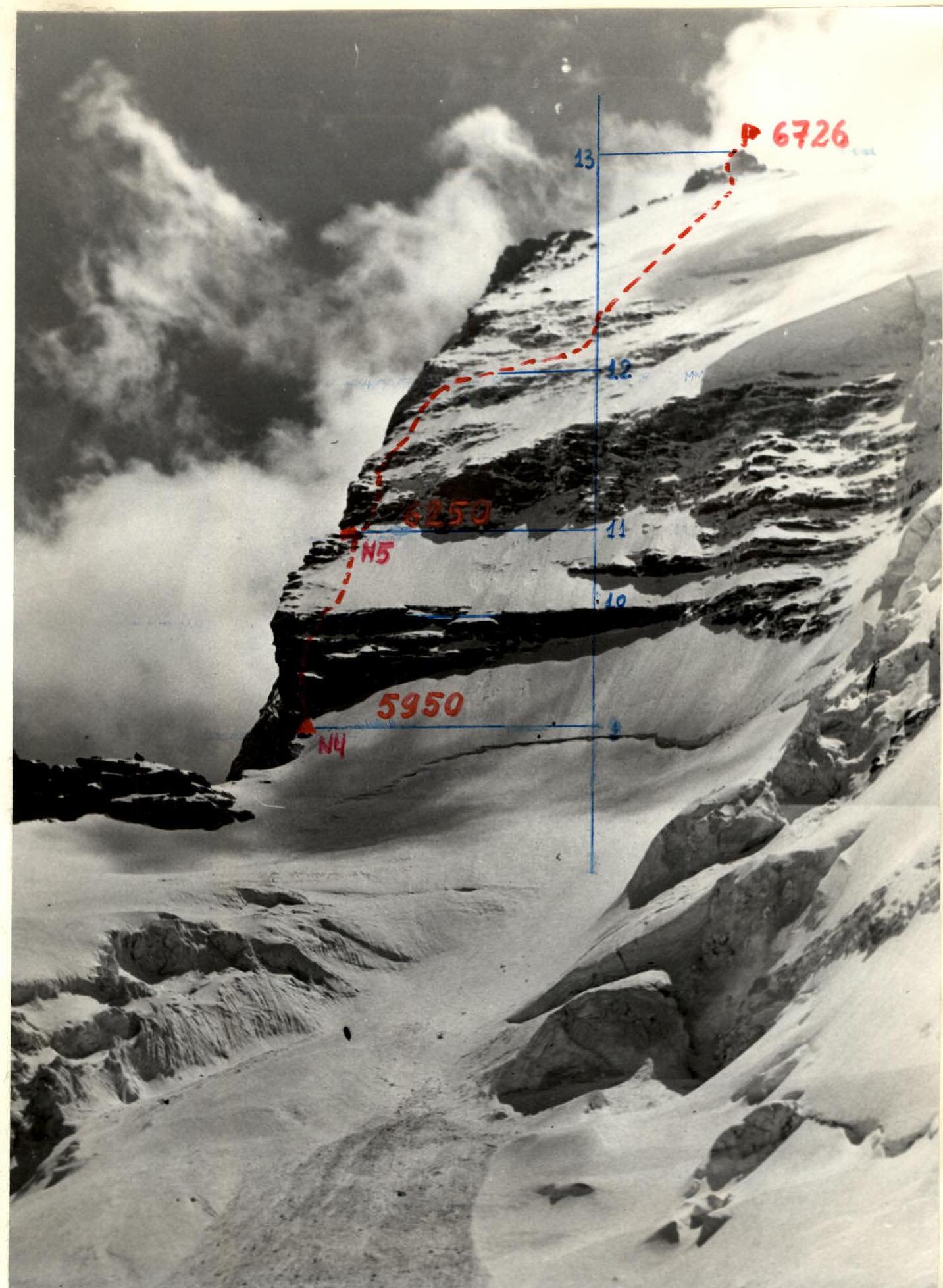 Photo #6. Sections R10–R13. Shooting point #5. August 22, 1986, 14:00. Lens MIR F=37. H=5400 m, L=1 km.