ASCENT DOCUMENT
-
Ascent class: High-altitude technical climb.
-
Ascent area: South-West Pamir.
-
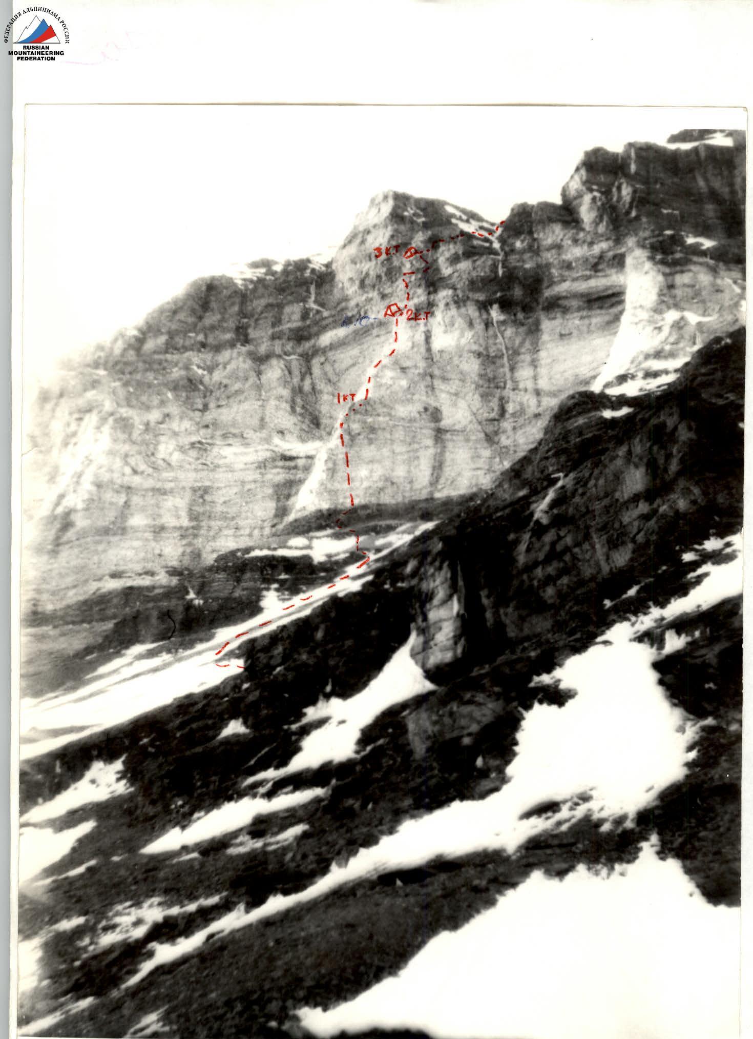
Ascent route: Ascent to Litva peak via the fourth bastion of the south-west wall H 6080 m.
-
Difficulty category: 5B
-
Wall section height difference — 420 m, length — 530 m, length of sections with 5th and 6th difficulty categories — 390 m.
-
Number of pitons driven
Rock Ice Bolt Chocks 47 7 0 66 4 0 0 4 -
Total climbing hours — 26, days — 3.
-
All bivouacs were lying down. Water was available in the form of snow.
-
Leader: Lavruha Sergey Vladimirovich — 1st sports category.
Team members:
- Voroshilov Alexey Nikolaevich — 1st sports category
- Kulakov Andrey Alexandrovich — 1st sports category
- Usenko Alexey Sergeevich — 1st sports category
-
Team coach: Kurgin Sergey Nikolaevich, Master of Sports of the USSR.
-
Approach to the route: July 13, 1988. On the summit — July 15, 1988. Descent to dusty bivouacs — July 15, 1988.
-
The ascent was organized by NOSK gatherings.
General photo of the summit. Camera "Smena 8M" 16:00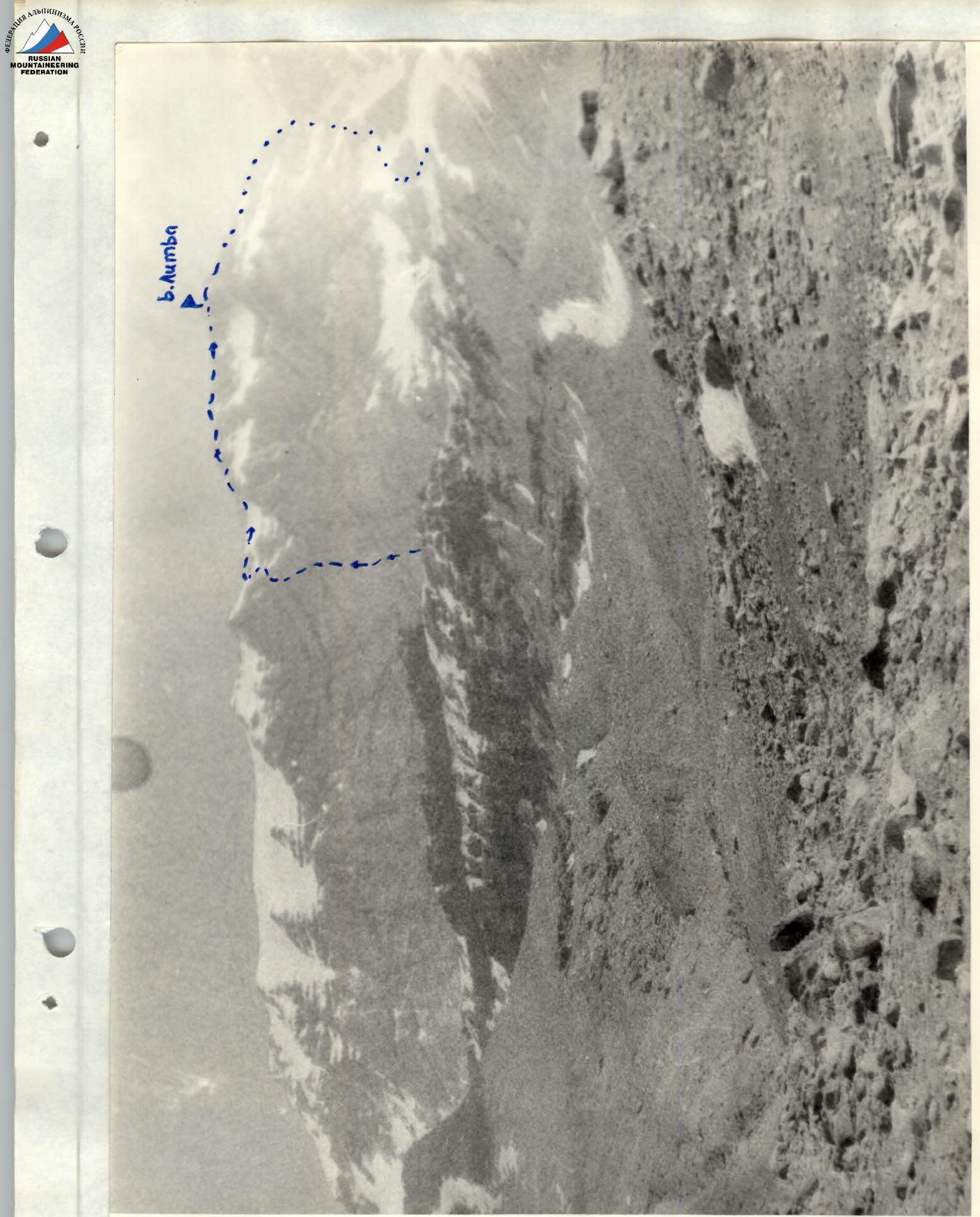
Panorama. Camera "Smena-8M" 10:00
Tactical actions of the team
The tactical plan for the ascent was based on the team's available data on the nature and complexity of the route, as well as taking into account the weather conditions in the area. The team's supplies were calculated for three days of travel. The equipment was selected considering the nature of the route and anticipating deteriorating weather conditions. The team had a diverse set of technical means: rock pitons, ice screws, chocks, and ladders.
The first climber was completely unloaded. To increase reliability, the following work scheme was adopted: the first climber went with a shock absorber on a double rope — of Soviet and foreign production. Having passed the next section of the route, one rope (Soviet) was secured, and the other was used to belay the second climber, who, following the fixed rope, pulled behind him the rope for belaying the next participant. The rest also followed the fixed ropes with belay. The lead climbers rotated according to the tactical plan. On the first day, Lavruha led, on the second — Kulakov, and on the third — Voroshilov.
The radio was with:
- on the first day — Kulakov;
- on the second and third days — Lavruha.
Bivouacs were organized in places that excluded the possibility of rockfall. All bivouacs were comfortable. On the first bivouac, there was no snow, so it had to be fetched from a shelf in the backpacks. Hot meals were prepared in the morning and evening. During the day, the participants used "pocket" food.
On the second day, due to unfavorable weather conditions, the group's departure was delayed by 3 hours. There were no other significant deviations from the tactical plan.
| CK | 3 | 1. | |
|---|---|---|---|
 | |||
| 4 | 4 | ||
| 4 | 3 |  | |
| 1 | 4 / 1 | ||
| 2 |  | ||
| 3 | 3 / 2 | ||
| 5/2 | 8/1 |  | |
| 2 | 3 |  | |
| 2 |  | ||
 |
Total climbing hours — 23.
Total: rock — 47, chocks — 66, ice — 7.
ROUTE DESCRIPTION BY SECTIONS
- P0–P1 — from the campsite on the "cold" bivouacs to the snow-ice slope leading under the fourth bastion of Litva peak. Snow-ice slope with islands of destroyed rocks, ascent in crampons.
- P1–P2 — ascent through destroyed rocks, ledges, and slabs under the wall.
- P2–P3 — beginning of movement up the wall — to the left of the projection of the rusty spot on the base of the wall. Up narrow inclined ledges and blocks. Many loose rocks from here and further — in galoshes.
- P3–P4 — sheer wall leading up narrow ledges to a chimney.
- P4–P5 — chimney. Climbing in wedged positions. At the top — a platform, on it the first control point.
- P5–P6 — from the first control point, traverse left under the cornice, then ascent up steep rock slabs.
- P6–P7 — steep, crumbling rocks leading to a niche.
- P7–P8 — ascent up smooth rocks with few holds, exit to a scree ledge.
- P8–P9 — inclined scree ledge.
- P9–P10 — smooth rocks with a crack going from left to right, leading to a long ledge. On it — the second control point. There is a convenient place for a tent. We set up a bivouac.
- P10–P11 — from here begins the belt of "black" rocks. The start of the movement is 15 m to the right of the tent. Smooth wall of solid rock without holds. Movement along a vaguely defined crack.
- P11–P12 — a ledge, then an inner corner leading under a triangular balcony.
- P12–P13 — the balcony is bypassed on the left, exit to a ledge. Along it, traverse left for 10 m.
- P13–P14 — sheer wall with few holds.
- P14–P15 — traverse right along narrow inclined ledges. Had to take a cold shower in a waterfall.
- P15–P16 — wall, then destroyed rocks. Movement from right to left under an overhanging cornice.
- P16–P17 — cornice with hanging icicles. Exit to a wide terrace. On it, the third control point. A convenient place for a bivouac. We set up a bivouac here.
- P17–P18 — traverse right along the terrace to a lowering in the rocks.
- P18–P19 — overhanging inner corner leading to a narrow ledge.
- P19–P20 — large rock slabs. In the morning, covered with ice. Traverse right along them, to the dome of the bastion, under the snow-ice couloir.
- P20–P21 — snow-ice couloir leading to the ridge.
- P21–P22 — along the snow-rock ridge with destroyed rocks, ascent to a standalone peak.
- P22–P23 — descent along the ridge to the saddle between Babel and Litva peaks.
- P23–P24 — ice icicle. Rappelling down it.
- P24–P25 — snow couloir leading to snow fields, along them traverse right, descent into a snow couloir leading directly to the "cold" bivouacs.