
Ascent Passport
-
Ascent class — high-altitude technical
-
Ascent area — Pamir, Petra I ridge
-
Peak, its height, and ascent route:
30 let Sovetskogo gosudarstva, 6447 m, via the center of the NE wall
-
Expected difficulty category — sixth
-
Route characteristics:
height difference — 2240 m, average steepness — 65°, section lengths: 1st diff. cat. — 30 m, 3rd diff. cat. — 135 m, 4th diff. cat. — 360 m, 5th diff. cat. — 1565 m, 6th diff. cat. — 590 m
-
Pitons driven:
for belaying: rock 176, chocks 15, ice 185; for creating ITO: bolt 10
-
Number of climbing hours — 70
-
Number of bivouacs and their characteristics:
seven bivouacs, including
- four lying
- three semi-reclining.
-
Surname, name, and patronymic of the leader, participants, and their sports qualification:
- Rizaev Leonid Mukhamedovich — Master of Sports, leader
- Aizenberg Viktor Aronovich — Candidate for Master of Sports, participant
- Kalmykov Sergei Grigorievich — Master of Sports, participant
- Lurie Vadim Rafailovich — Master of Sports, participant
- Oganesov Artem Oganesovich — Candidate for Master of Sports, participant
- Cherepov Vladimir Alekseevich — Master of Sports, participant
-
Team coach: Kapitanov Oleg Viktorovich.
-
Date of departure and return:
August 14, 1980 — reconnaissance August 15, 1980 — departure August 24, 1980 — return

Route profile from above. Photo from the editorial office of "Burevestnik"

Route sketch TABLE OF MAIN ROUTE CHARACTERISTICS Table 1.
| Date | Section | Steepness | Length (m) | Terrain characteristics | Difficulty | Condition | Weather conditions | Rock pitons | Ice pitons | Bolt pitons |
|---|---|---|---|---|---|---|---|---|---|---|
| August 14 | R0–R1 | 75° | 25 | ice wall | 5 | good | 2 | 4 | - | |
| R1–R2 | 35° | 40 | icy rocks | 3 | destroyed | good | 4 | 2 | - | |
| R2–R3 | 50° | 60 | ice couloir, rocks | 4 | good | - | 4 | - | ||
| Reconnaissance from 18:00 to 20:00 | ||||||||||
| August 15 | R3–R4 | 75° | 65 | edge | 5 | monolith | good | 8 | - | - |
| R4–R5 | 45° | 40 | wall | 4 | destroyed | " | 6 | - | - | |
| R5–R6 | 0° | 30 | ledge | 2 | destroyed | " | 2 | - | - | |
| R6–R7 | 70° | 70 | couloir | 5 | icy | " | 12 | 2 | - | |
| R7–R8 | 45° | 60 | couloir | 3 | destroyed | " | 10 | - | - | |
| R8–R9 | 0° | 40 | couloir | 4 | icy | " | 4 | 2 | - | |
| R9–R10 | 75° | 125 | wall | 5 | destroyed | " | 12–13 | - | - | |
| R10–R11 | 70° | 100 | edge | 5 | monolith, icy | " | 10–5 | - | - |
Departure from base camps at 7:00. Start of work at 8:30 on processed ropes and at 9:00 further along the route. Stopped for bivouac at 17:30. From 17:30 to 19:00, one team processed the further route. Climbing hours — 9. Bivouac lying down.
| August 16 | R11–R12 | 0° | 25 | wall | 4 | destroyed | good | 4 | - | - | | | R12–R13 | 75° | 100 | wall | 5 | fragile rocks | " | 16 | - | - |
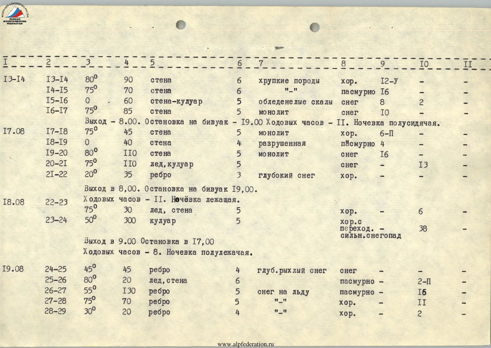
| R13–R14 | 80° | 90 | wall | 6 | fragile rocks | good | 12–5 | - | - | |
|---|---|---|---|---|---|---|---|---|---|---|
| R14–R15 | 75° | 70 | wall | 6 | "-" | overcast | 16 | - | - | |
| R15–R16 | 0° | 60 | wall-couloir | 5 | icy rocks | snowfall | 8 | 2 | - | |
| R16–R17 | 75° | 85 | wall | 5 | monolith | snowfall | 10 | - | - | |
| Departure at 8:00. Stop for bivouac at 19:00. Climbing hours — 11. Bivouac semi-sitting. | ||||||||||
| August 17 | R17–R18 | 75° | 45 | wall | 5 | monolith | good | 6–11 | - | - |
| R18–R19 | 0° | 40 | wall | 4 | destroyed | overcast | 4 | - | - | |
| R19–R20 | 80° | 110 | wall | 5 | monolith | snowfall | 16 | - | - | |
| R20–R21 | 75° | 110 | ice, couloir | 5 | snowfall | - | 13 | - | ||
| R21–R22 | 20° | 35 | edge | 3 | deep snow | good | - | - | - | |
| Departure at 8:00. Stop for bivouac at 19:00. | ||||||||||
| August 18 | R22–R23 | Climbing hours — 11. Bivouac lying down. | ||||||||
| R22–R23 | 75° | 30 | ice, wall | 5 | good | - | 6 | - | ||
| R23–R24 | 50° | 300 | couloir | 5 | good, then heavy snowfall | 38 | - | |||
| Departure at 9:00. Stop at 17:00. Climbing hours — 8. Bivouac semi-reclining. | ||||||||||
| August 19 | R24–R25 | 45° | 45 | edge | 4 | deep, loose snow | snowfall | - | - | - |
| R25–R26 | 80° | 20 | ice, wall | 6 | overcast | - | 2–11 | - | ||
| R26–R27 | 55° | 130 | edge | 5 | snow on ice | overcast | - | 16 | - | |
| R27–R28 | 75° | 70 | edge | 5 | "-" | good | - | 11 | - | |
| R28–R29 | 30° | 20 | edge | 4 | "-" | good | - | 2 | - |

| August 20 | R29–R30 | 70° | 100 | narrow ice edge with ice pillars | 6 | good | - | 16–8 | - | |
|---|---|---|---|---|---|---|---|---|---|---|
| R30–R31 | 50° | 55 | same | 5 | good | - | 8 | - | ||
| R31–R32 | 65° | 55 | edge-wall | 5 | ice | good | - | 12 | - | |
| Departure at 9:00. Stop for bivouac at 19:00. Climbing hours — 10. Bivouac semi-reclining. | ||||||||||
| August 21 | R32–R33 | 0° | 30 | ice wall | 5 | ice, flowstone | good | - | 6 | - |
| R33–R34 | 80° | 280 | ice couloir | 6 | hard ice | good | - | 35 | - | |
| R34–R35 | 85° | 30 | ice wall | 6 | flowstone | good | 1 | 4 | - | |
| Departure at 9:00. Stop for bivouac at 20:00. Climbing hours — 11. Bivouac lying down. | ||||||||||
| August 22 | R35–R36 | 55° | 90 | edge | 4 | snowy rocks | good | 3 | - | - |
| Departure at 10:00. Reached the summit at 11:00. Climbing hours to the summit — 1. |
Brief explanation of Table 1.
The route begins with an ice wall of the bergschrund (R0–R1), using ice axes and specialized ice picks greatly facilitates passage. Tubular ice screws go well.
The wall leads to icy, destroyed rocks, then left upwards, crossing an ice gully, to a rock wall. Along a vaguely expressed edge — to a gently sloping, destroyed wall that leads to a ledge (R1–R5). The ledge leads to an ice couloir. The couloir is rockfall-prone, so further ascent is up its left side to a wider and less steep part.
The rocks are steep and smooth, partly icy. Climbing is complex. Then a gentle, heavily destroyed wall leads to the safest place to cross the couloir (R5–R9).
A steep, smooth wall, partly icy, leads under an edge (R9–R10). Here you can set up a bivouac site.
Very complex and tense climbing along the edge (R10–R11) leads to a wall. Traverse left to a vaguely expressed couloir and again upwards. Climbing is complex, requires great attention and caution, as the rocks are fragile (R11–R13).
The route on section R13–R15 passes along a wall of northern orientation, composed of fragile black rocks. Climbing is very complex, requiring the use of long rock pitons, channels, or "carrots". The route is complicated by sections of icy and snowy rocks.
Next, it is necessary to traverse the couloir. This is the most dangerous place on the route. For safety, a spot was chosen (R15–R16) where the couloir is divided into two gullies.
At this point, two sections, about 20 m each, are hazardous. But the approach along the wall to these sections is quite complex. Then a steep wall (R16–R17) leads to a safe place. There is no bivouac site. Two hours of construction work allow for a semi-sitting bivouac. A control tour in a bag, secured to a piton.
45 m up the wall lead to an edge, then a traverse, and after 100 m of complex climbing along a steep monolith — exit under a hanging glacier (R17–R20).
Two ropes along a steep ice couloir lead to an edge of the central glacier. A little upwards — and a good place to organize bivouacs (R20–R22).
Having overcome the ice drop wall (very complex and dangerous), we exit to the left side of a huge couloir. 300 m of tiring ice work and sharply worsening weather force an urgent search for a safe place for a bivouac (R22–R24).
In the morning, bad weather continues, with trains of avalanches rushing down the couloir. Up through deep, loose snow to an ice crevasse. Very complex and dangerous climbing along an ice wall consisting of icicles in the snow (R24–R26).
Further along a steep ice edge under a "step", where you can organize an excellent bivouac (R26–R29).
On section R29–R30, the path goes along a narrow ice edge between two couloirs. It is too dangerous to go along the couloirs, and the edge is composed of ice "gendarmerie" — fragile ice formations of porous structure. It gives the impression of being a pillar made of twisted ice icicles. The section is extremely complex both psychologically and technically.
On section R30–R31, it is somewhat simpler due to the lesser steepness of the edge.
Further, a belt of ice-filled rocks begins. Along steep, icy rocks and an ice gully — exit to a narrow, knife-like ice ridge (R31–R32), on which a small site is cut out (sitting bivouac).
From the site:
- upwards,
- traverse right along flowstone ice (very complex) into an ice couloir leading to the summit ridge (R32–R33).
Along the left side of the couloir spill (rocks constantly rumble on the right):
- on very hard, sometimes flowstone, ice, polished by small avalanches,
- further along a steep ice gully — exit to the ridge (R33–R35).
The section is technically very complex, tense, and lengthy, requiring the use of modern methods of ice technique and equipment.
Along the snowy rocks of the ridge — exit to the summit (R35–R36).
Comments
Sign in to leave a comment