ASCENT REPORT
-
Ascent category — high-altitude and technical
-
Ascent area — Peter the First Ridge
-
Peak, its height, route — Peak Abalakov via the north face (Georgian route), height 6446 m
-
Difficulty category — 6B complexity category
-
Route characteristics: Elevation gain — 2350 m. Average slope — 58°. Section lengths: 1st cat. diff. — absent, 2nd cat. diff. — absent, 3rd cat. diff. — 240 m, 4th cat. diff. — 900 m, 4–5 cat. diff. — 1080 m, 5th cat. diff. — 960 m, 5–6 cat. diff. — 520 m. Total length from the bergschrund — 3580 m
-
Pitons used for protection:
| Rock pitons | - | 156 |
|---|---|---|
| Ice pitons | - | 38 |
-
Total climbing hours — 43 hours
-
Number of bivouacs and their characteristics: 5 bivouacs:
- 1st — on the glacier below the route;
- 2nd, 3rd, 4th — on the route, all three in a tent;
- 5th — below the summit on the descent.
-
Full name of the leader and participants, their sports qualification:
- Kovtun Natalia Petrovna — Candidate Master of Sports — leader;
- Balinsky Anatoly Pavlovich — Master of Sports — participant;
- Moskaltsov Alexey Vadimovich — Candidate Master of Sports — participant;
- Kharianyk Ivan Vasilyevich — Candidate Master of Sports — participant
-
Team coach: KOVTUN Vasily Grigoryevich.
-
Date of departure and return: from August 12, 1979 to August 18, 1979
 www.alpfederation.ru↗
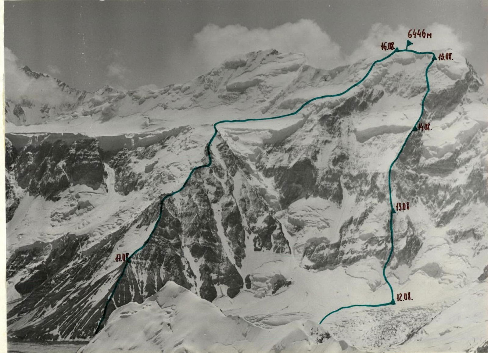 www.alpfederation.ru↗
Ascent Description
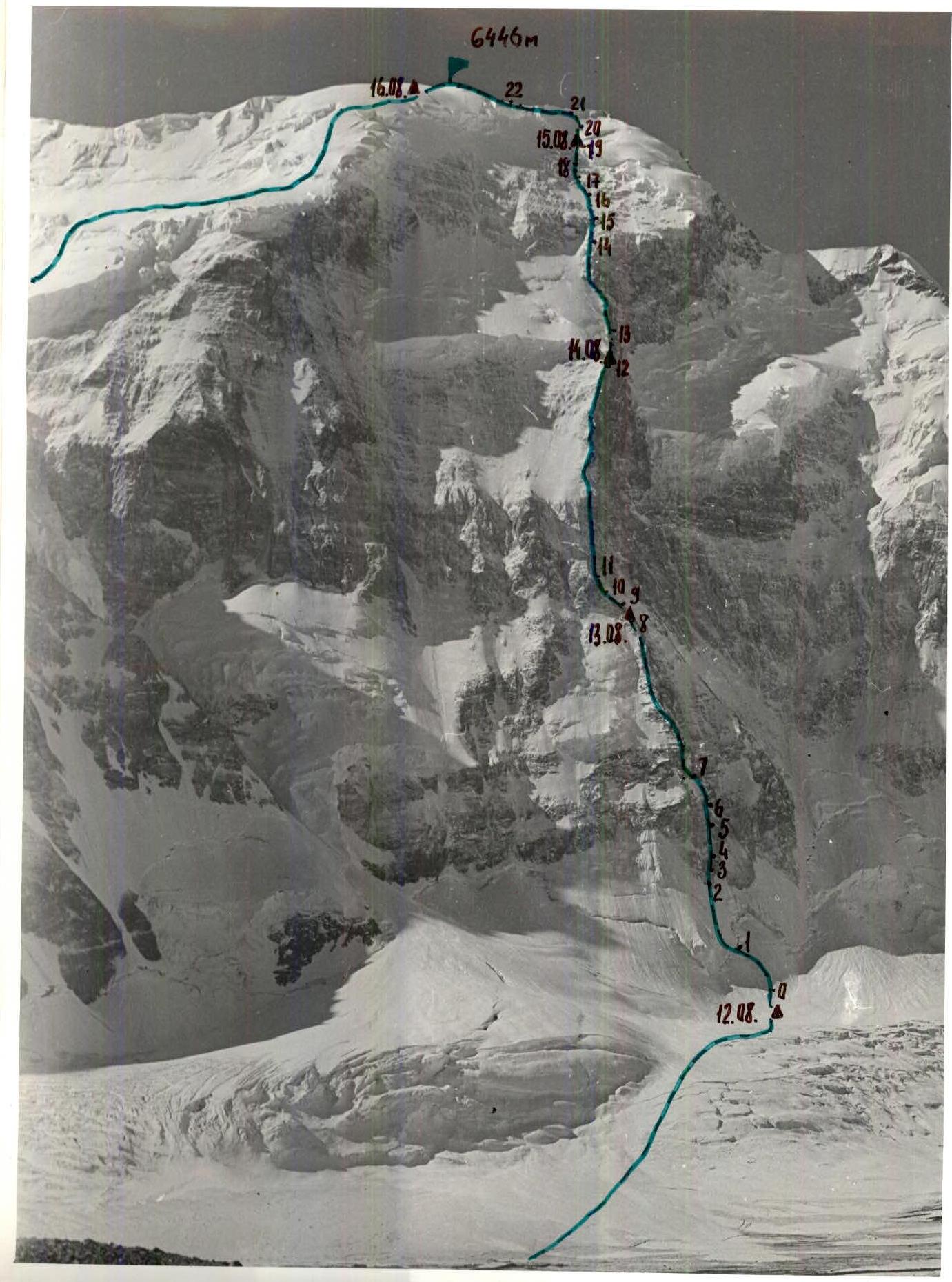
August 12
The group departed from the base camp at 11:00. The route went along the right lateral moraine of the Fortambek Glacier, then across the center of the glacier where it turns towards the "Submarine", and then left under the north face of Peak Abalakov. They reached the base of the face at 13:30, set up a tent in a safe location on the glacier, and began observing the route. That day, they decided to process the lower part of the route and return to the bivouac on the glacier. They started processing at 17:30. Quickly traversing the avalanche cone, they approached the bergschrund. After finding the easiest path through the bergschrund, they began ascending the ice slope. The initial 7 meters had a steepness of 70°, which they easily overcame using "Stubai" crampons and an ice axe. The ice slope then eased to 50°–55° (section 1–2), covering two 60 m rope lengths. The presence of snow on the ice surface complicated their progress. After traversing two rope lengths of ice, they approached the start of a rocky bastion.
Their path then went straight up moderately difficult rocks — steep and quite broken. After 60 m, they returned to their bivouac. The processing took 3.5 hours.
August 13
They departed at 8:00. Using the pre-made steps, they quickly traversed the avalanche cone and approached the bergschrund. They followed the previously processed sections. The first climber was very cautious, checking the integrity of the ropes and the quality of their anchoring to the pitons. They then proceeded with another 60 m rope length — moderate difficulty climbing on a broken rocky bastion (section 3–4). This was followed by 240 m (4 rope lengths) of challenging climbing on steep rocks with a slope of about 80°. The presence of rime ice on the rocks made this section particularly difficult (section 4–5). They then climbed one more rope length upwards and to the right — moderate difficulty climbing, emerging onto a ridge (section 5–6). The rocks were snowy, broken, and prone to rockfall.
They continued along the ridge (section 6–7), which gradually eased to 45°–50°, covering another 8 rope lengths of snowy rocks (section 7–8). They reached a control cairn. Near the cairn, they found a flat area covered in ice, likely an old bivouac site. After preparing the area, they settled in for the night. They worked for 11 hours that day. The cairn contained a note from a repeat ascent team — Bobrov's group.
August 14
They departed at 9:00. It was very cold, with occasional snowfall and strong winds. They later learned that a cyclone had passed over the Pamir region. They decided to leave the third rope behind and continue with two 60 m ropes.
From their bivouac, they climbed one rope length along the rocky ridge (section 8–9), then traversed a snowy-icy slope upwards to the left, beneath the onset of a counterfort (section 9–10). The snowy-icy slope was quite steep — 55°. The climb was complicated by alternating sections of deep fresh snow and smooth rime ice covered with a thin layer of fresh snow. It was very cold, and even their 12-tooth crampons provided poor traction on the rime ice. They had to use ice pitons, but they often shattered the ice, and their ice axe did not hold well in the loose snow. They traversed this section very cautiously and emerged at the onset of the counterfort (section 10–11). They climbed the onset — one rope length, with a steepness of 60° (section 10–11) — and continued onto the counterfort. Along the center of the counterfort, they climbed upwards through rocks that were partly very broken, layered, heavily snowy, and in places covered with rime ice. The average steepness was 55°, with occasional steeper sections up to 70°. The climbing was of moderate difficulty, covering 12 rope lengths (section 11–12). They reached a suitable bivouac site at 19:30. Within an hour, they prepared a platform and set up their tent. They worked for 10 hours and 30 minutes that day. Their bivouac was on a ridge, at the level of the icefall, which was now safe for them.
August 15
They departed at 9:00. From their bivouac, they climbed one rope length through rocks with a steepness of 60° (section 12–13). Their path then followed the rocks of the counterfort along a snowy-icy slope (protection via ice axes). The slope had a steepness of 45°, covering a total of 7 rope lengths to the upper edge of the snowy-icy slope (section 13–14). From the upper edge, they climbed one rope length to the right, onto the counterfort, to its end (section 14–15). They then continued through heavily snowy, broken rocks, with moderate difficulty climbing, deviating left from the right icefall towards the upper edge of the rocks, roughly midway between the icefalls (the rocks ended at the level of the right icefall). On this section, they encountered one snowy pitch — 2 rope lengths (section 15–16) — and a steep rocky pitch — 180 m with a steepness of 60°, challenging climbing (section 17–18).
From the end of the section, they traversed to the right and upwards across a snowy slope with an initial steepness of 45°, easing to 30°, covering 3 rope lengths (section 18–19). The snow was very loose and deep. They had to wade through waist-deep snow, creating a trench. Beneath the snow lay ice. Throughout the day, they did not encounter a single spot suitable for setting up a tent. Although it was already very late, they decided to traverse the hazardous snowy pitches and approach the ridge. At 23:00, they reached a suitable snowy area and trampled a platform for their bivouac.
They worked for 14 hours that day.
August 16
The weather deteriorated. A very dense fog reduced visibility to 10–15 m. Due to this, they departed late — at 11:00. From their bivouac, they climbed straight up a snowy slope with a steepness of 30° (two rope lengths, section 19–20), then through a rocky ridge with a steepness of 45° — emerging onto the ridge to the left of a group of gendarmes (section 20–21). The ridge had large cornices on the southern side. They traversed the ridge along the northern slope, below the line of cornice overhangs. The slope was steep — about 50°, with ice in places being rime ice, covering 2.5 rope lengths (section 21–22). They emerged onto a broad summit ridge, along which they climbed approximately 300 m to reach the summit at 14:40. From their bivouac to the summit took 4 climbing hours. The fog remained very dense. They decided to begin their descent towards the Abalakov — Leningrad saddle. After proceeding 100 meters, they realized that finding a safe descent route in such fog would be very challenging, so they returned to the summit, set up a tent in a depression, and trampled a deep platform, constructing walls from snow bricks. Snowfall occurred during the night, accompanied by very strong winds.
August 17
The morning was clear, frosty, and windy. It was very cold, but they could now see their descent route. They departed at 9:00. They decided to descend towards Peak Parachutists via the route taken by Kavunenko's group, with a subsequent deviation to the right onto the plateau. They descended with alternating protection. There was a lot of fresh snow.
Upon reaching the plateau, they organized two rappels:
- the first was 20 m with the retrieval of ice axes;
- the second was 60 m, exiting onto the plateau.
They then traversed the plateau and reached Peak Parachutists by 15:00. After resting and having lunch, they began their descent along the "Burvestnik" ridge at 18:00. They reached the "Verblyud" by 19:15 and set up their final bivouac on the lowest platform of the "Burvestnik" ridge at 21:00.
August 18
They departed at 7:00. By 8:30, they were back at the base camp on Suloev's clearing.
Brief Description for the Table
Section 0–1 — avalanche cone — recommend traversing either early in the morning or late in the evening due to possible icefall from the seracs to the left of the ridge. 1–2 — steep ice, two 60 m rope lengths, steepness 50–55°, with an initial 7 m ice section at 70°. 2–3 — 60 m — beginning of the rocky bastion — moderately difficult rocks, broken and slab-like. 3–4 — moderately difficult rocks, 60 m, broken and slab-like. Rockfall possible. 4–5 — challenging, steep rocks, 240 m, with rime ice. 5–6 — sixty-meter wall, snowy, prone to rockfall. 6–7, 7–8 — rocky ridge, initially steep — 60°, then easing to 45–50°, total length 600 m. 8–9 — steep ascent on the ridge — 60 m, rocks with rime ice. 9–10 — steep snowy-icy slope, complicated by uncertain protection. 10–11, 11–12 — counterfort with a steep onset at 60 m and subsequent broken terrain. Complicated by rime ice on rocks. Total length — 780 m. 12–13 — 60 m of challenging climbing on slab-like rocks. 13–14 — seven rope lengths along a snowy-icy slope at 45°. 14–15 — exit onto the counterfort, with one rope length of challenging climbing (smooth lobes with rime ice). 15–16 — two rope lengths of steep snow, very loose and powdery after a week of bad weather.
TABLE OF MAIN ROUTE CHARACTERISTICS
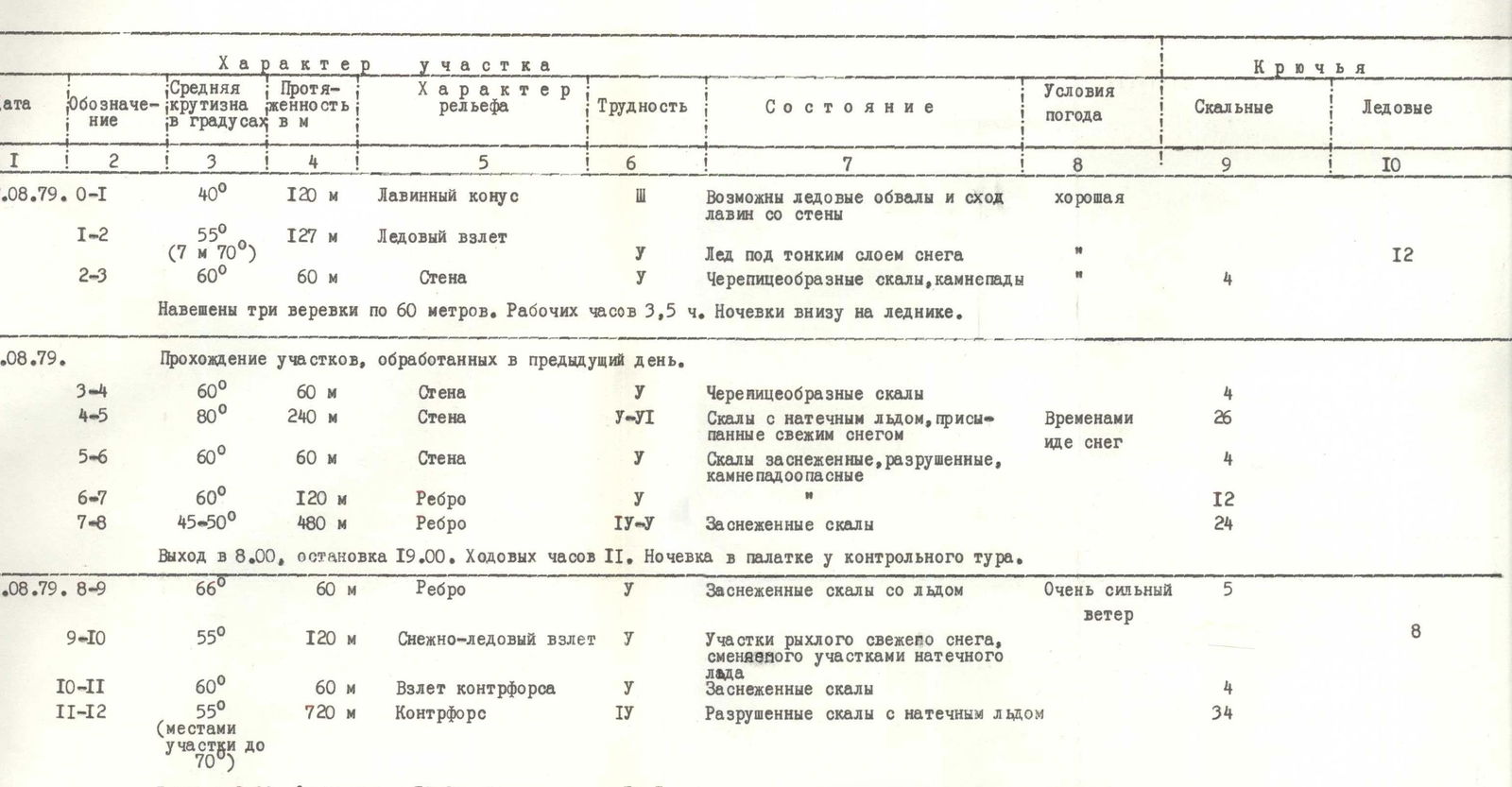
| Date | Designation | Average steepness in degrees | Length in m | Terrain characteristics | Difficulty | Condition | Weather conditions | Rock pitons | Ice pitons |
|---|---|---|---|---|---|---|---|---|---|
| 12.08.79. | 0–1 | 40° | 120 m | Avalanche cone | 2 | Possible ice and avalanche hazards from the face | good | ||
| 1–2 | 55° (7 m 70°) | 127 m | Ice pitch | V | Ice beneath a thin layer of snow | 10 | 12 | ||
| 2–3 | 60° | 60 m | Wall | V | Tiled rocks, rockfall | 4 | |||
| Three 60 m ropes used. Working hours: 3.5 hours. Bivouac below on the glacier. | |||||||||
| 13.08.79. | Passage of sections processed the previous day. | ||||||||
| 3–4 | 60° | 60 m | Wall | V | Tiled rocks | 4 | |||
| 4–5 | 80° | 240 m | Wall | V–VI | Rocks with rime ice, covered with fresh snow | Occasional snowfall | 26 | ||
| 5–6 | 60° | 60 m | Wall | V | Snowy rocks, broken, prone to rockfall | 4 | |||
| 6–7 | 60° | 120 m | Ridge | V | 12 | ||||
| 7–8 | 45–50° | 480 m | Ridge | IV–V | Snowy rocks | 24 | |||
| Departure at 8:00, stop at 19:00. Climbing hours: 11. Bivouac in a tent by the control cairn. | |||||||||
| 14.08.79. | 8–9 | 66° | 60 m | Ridge | V | Snowy rocks with ice | Very strong winds | 5 | |
| 9–10 | 55° | 120 m | Snowy-icy pitch | V | Sections of loose fresh snow alternating with rime ice | 8 | |||
| 10–11 | 60° | 60 m | Counterfort onset | V | Snowy rocks | 4 | |||
| 11–12 | 55° (sections up to 70°) | 720 m | Counterfort | IV–V | Broken rocks with rime ice | 34 | |||
| Departure at 9:00, stop at 19:30. Climbing hours: 10.5. Bivouac in a tent at the level of the icefall. | |||||||||
| 15.08.79. | 12–13 | 60° | 60 m | Wall | V–VI | Challenging, broken, slab-like rocks | Windy, | 6 | |
| 13–14 | 45° | 420 m | Snowy-icy slope along the counterfort | IV–V | Much fresh snow | frequent | 9 | ||
| 14–15 | 65° | 60 m | Along the counterfort | V–VI | Rocky smooth lobes covered in ice | snowfall | 5 | ||
| 15–16 | 45° | 120 m | Snowy pitch | IV | Loose, fresh snow | ||||
| 16–17 | 55° | 180 m | Indistinct ridge | IV–V | Very snowy rocks | 16 | |||
| 17–18 | 65° | 180 m | Challenging rocky pitch | V–VI | Rocks with rime ice | 18 | |||
| 18–19 | 40° | 180 m | Snowy slope | V | Deep, loose snow; ice beneath; avalanche hazard | 12 | |||
| Departure at 9:00. Stop at 23:00. Climbing hours: 14. Bivouac in a tent on a snowy slope. | |||||||||
| 16.08.79. | 19–20 | 30° | 120 m | Snowy slope | 2 | Dense snow, occasional ice sections | Very dense fog | ||
| 20–21 | 45° | 60 m | Rocky ridge | IV | Covered with rime ice and snow | Visibility 10–15 m | 2 | ||
| 21–22 | 50° | 150 m | Icy ridge leading to a broad summit ridge (300 m to the summit) | V | Rime ice | 9 | |||
| Departure at 11:00, reached the summit at 14:00. Working hours: 4. Bivouac on a snowy ridge, after the summit in a tent. | |||||||||
| August 17, 1979 | Descent to the plateau, then ascent to Peak Parachutists and descent along the "Burvestnik" ridge to the final bivouac sites on the ridge. Descent started at 9:00, reached Peak Parachutists at 15:00, rested for 3 hours from 18:00 to 21:00 — descended along the "Burvestnik" ridge. Weather: excellent. | ||||||||
| 18.08.79. | Departed at 7:00, arrived at the camp on Suloev's clearing by 8:30. |
18–19 — snowy pitch after bad weather is very hazardous due to potential avalanches; traversed between 21:00–23:00.
19–20, 20–21 — straightforward snowy slope, practically safe, leading to moderately difficult rocks, snowy.
21–22 — traverse of an icy ridge, steep, with rime ice in places. The icy ridge transitions into a broad snowy pre-summit ridge with minimal elevation gain, along which 300 m to the summit.
Leader

N. Kovtun