
Ascent Passport
- Ascent Class: Technical
- Ascent Region: South-West Pamir
- Ascent Route: Peak 5080 m with ascent via the hanging glacier of the North-West Ice Wall.
- Ascent Characteristics:
- height difference — 1425 m
- average steepness — 50°
- length of complex sections — 200 m – 5A cat. diff.
- Pitons Hammered:
- rock: 8 pcs.
- ice: 126 pcs.
- Total Climbing Time: 22 h 30 min.
- Number of Nights on the Route: one.
- Team Name: Kharkov Regional Council of the "Avangard" Sports Society
- Surname, Name, Patronymic of the Leader, Participants, and their Qualification:
- NAGORNY S.I. — 1st sports category, leader
- POBEREZOVSKY V.I. — Candidate Master of Sports
- MELESHCHENKO A.V. — 1st sports category
- BORODICH T.P. — 1st sports category
- Team Coach: Master of Sports of the USSR, Honored Coach of the Ukrainian SSR SPESIVTSEV A.E.
- Date of Departure and Return: departure on July 28, return on July 30.
Brief Geographical Description and Sporting Characteristics of the Region
The Kharkov city sports committee and the regional council of the "Avangard" Sports Society organized an expedition in the summer season of 1975 to a new region for climbers in the South-West Pamir, in the Vez-Dara river valley, to participate in the USSR and Ukrainian SSR championships. Our expedition was joined by expeditions from the Ukrainian Sports Committee (Severodonetsk) and Donetsk.
The Vez-Dara valley is located in the South-West Pamir, 50 km from the city of Khorog — the capital of the Gorno-Badakhshan Autonomous Region, which celebrated its 50th anniversary in 1975.
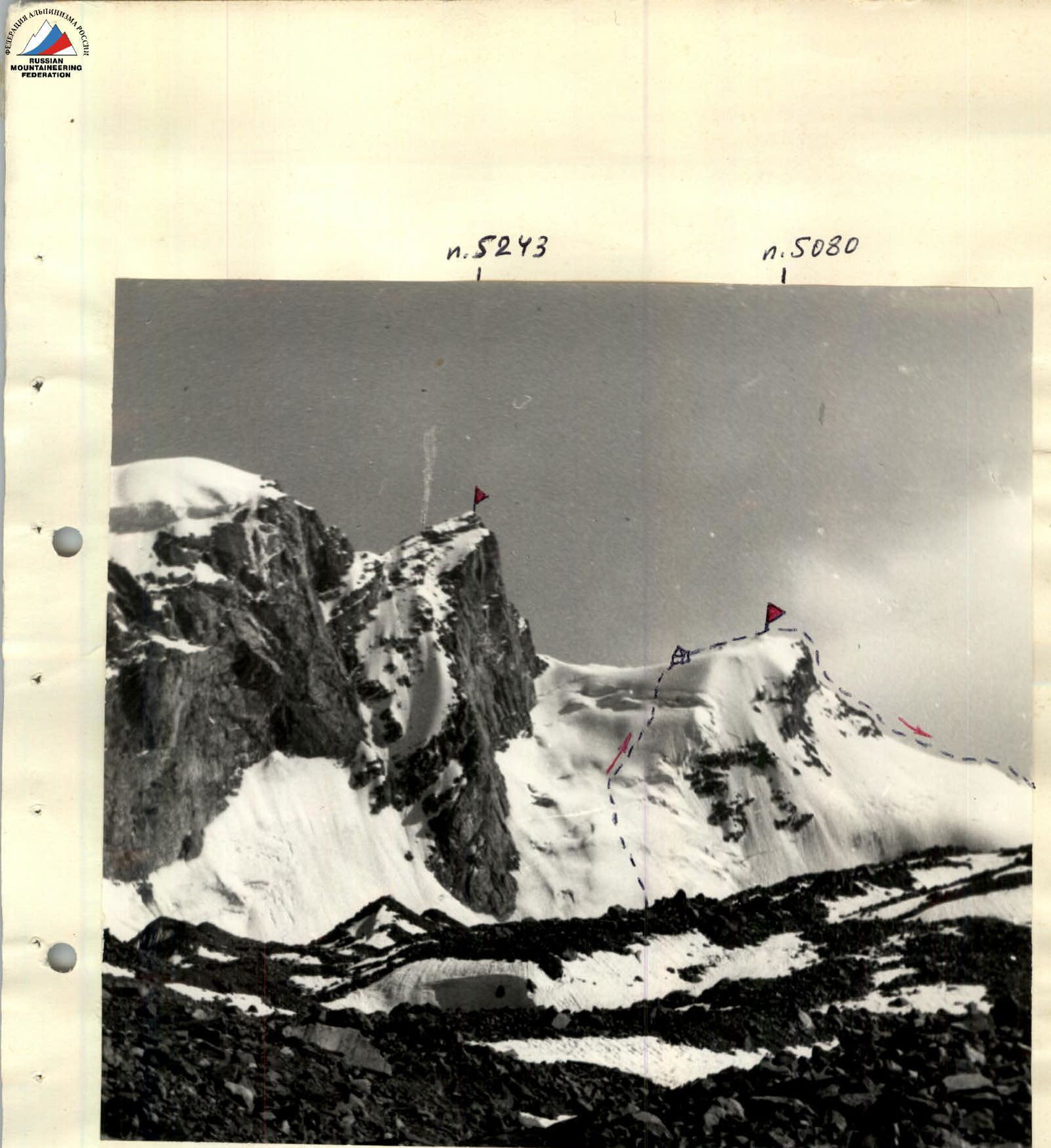
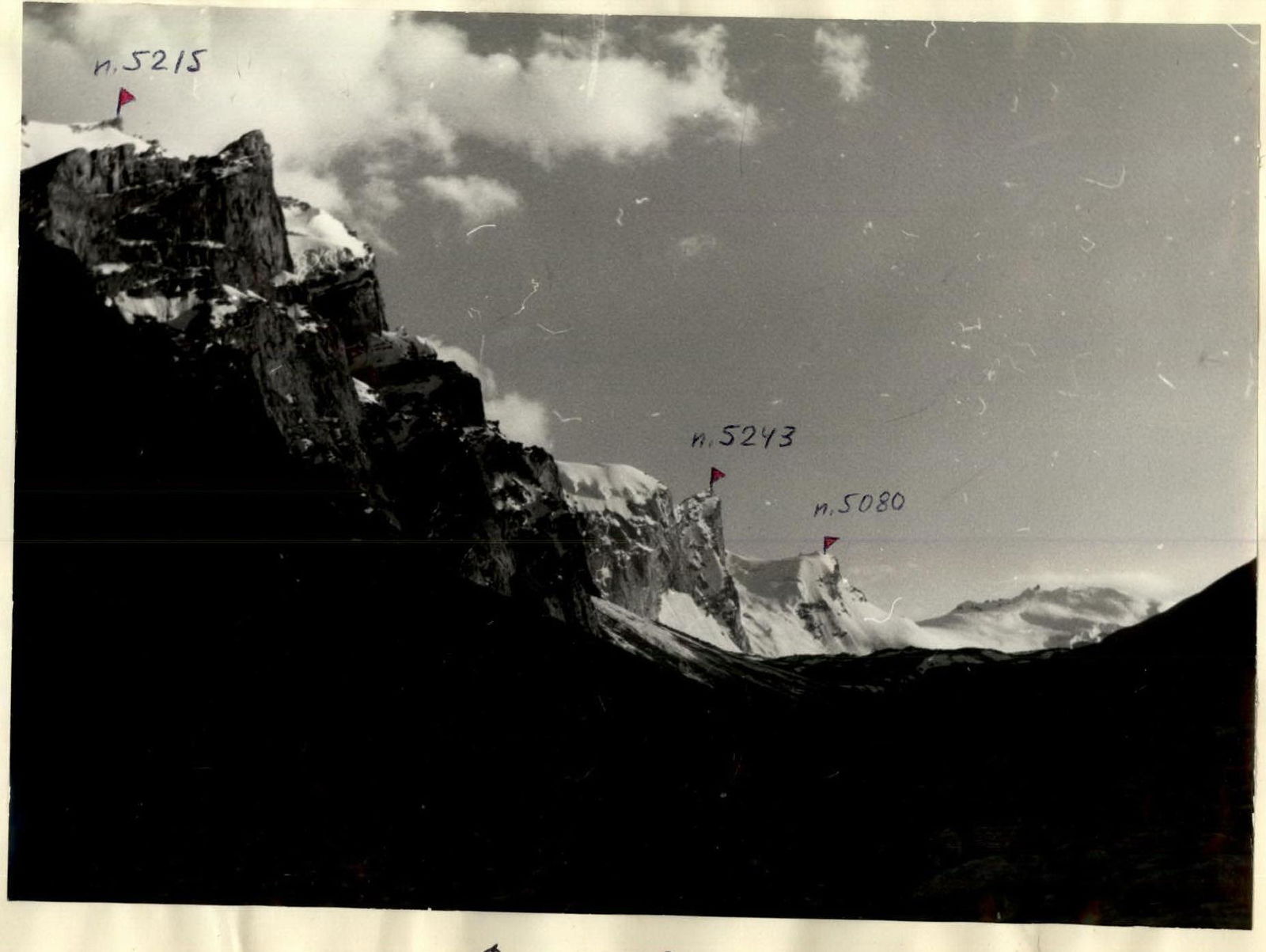
From the city of Khorog, along the Shakhdara river, there are regular buses to the village of Roshtkala (43). 7 km above is the village of Vez, where the Vez-Dara river flows into the Shakhdara river. The village of Roshtkala has shops, a club, a school, a post office, a hospital, a village council, and a collective farm headquarters. The Shakhdara river valley is one of the few forested areas of the Pamir. The forests stretch for many tens of kilometers here. In some places, they rise to altitudes of around 3000 m. An example is the Vez-Dara valley, where significant forest areas can be found in the lower and middle reaches, making it possible to organize a convenient base camp (see photo No. 1). The length of the valley is about 22 km. In the upper reaches, through the Vez pass, one can access the Garm-Chashma valley. The peaks in the Vez-Dara valley have heights of 5000–5200 m, with the highest point being 5243 m. This peak was conditionally named "Peak Nadezhda" (Hope). Our base camp was set up near a mineral water spring with a water temperature of 25–26 °C, which, according to local residents, is considered therapeutic. There are about 25 peaks in the area that had not been climbed before our expedition.
A distinctive feature of this region is the presence of sheer walls, mainly with a Western and North-Western exposure. A peculiarity of most of these walls is that they do not have a "roof" with snow, as after the sheer wall, there is a bend and then a descent (see photo No. 2). Many walls lack sections with snow and water, so it is necessary to bring snow or water from below.
Our object of ascent — Peak 5080 m with ascent via the hanging glacier of the North-West Ice Wall — serves as both a training and a reconnaissance climb, as it allows for a good study of the chosen route for ascending Peak 5243 m, with the aim of participating in the Ukrainian SSR alpine championship.
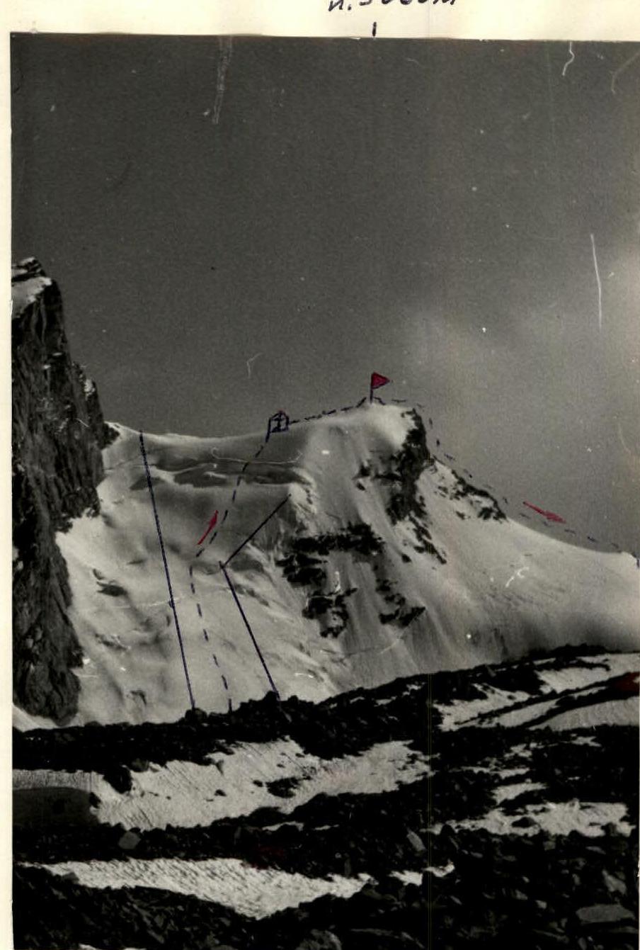
From below, a logical and safe "corridor" is visible — the path to Peak 5080 m via the hanging glacier of its North-West Ice Wall, which is overcome mainly on the front teeth of crampons with insurance through ice screws (see photo No. 3).
Previously, there were no climbed routes in this area, so all routes were first ascents.
Organizational and Tactical Plan
To participate in the USSR and Ukrainian SSR alpine championships, a joint expedition was organized by the cities of Kharkov, Severodonetsk, and Donetsk. The initiator and organizer of this expedition was the Alpine Federation of Kharkov. The Kharkov expedition was the base one in terms of the number of participants and their qualifications. The overall leadership of the expedition was entrusted to Master of Sports, Senior Instructor, and Deputy Chairman of the Kharkov Alpine Federation Grigorenko-Prigoda Yu.A.
The expedition included highly qualified teams:
- Kharkov — participation in the USSR championship
- Severodonetsk — participation in the USSR championship
- Donetsk — participation in the USSR championship
- Kharkov — participation in the Ukrainian SSR championship (technical class)
- Kharkov — traverses
The presence of such teams allowed for planning all ascents in a way that there was always a qualified rescue team in the camp.
The expedition's working time was chosen based on our observations from 1971–1974. Thus, the winter snows completely cleared the upper sections of the wall routes and ridges, and stable weather was established. The South-West Pamir typically has stable, good weather from the second half of July until almost the end of August.
The main composition of the expedition arrived in Vez-Dara on July 3. To participate in the Ukrainian SSR alpine championship in the technically complex ascents class, the team chose the object — Peak 5243 m. After organizing the base camp, reconnaissance exits, and observations of the object, the team proceeded to carry out training and reconnaissance ascents of 2B–4B cat. diff., the last of which was the actual route to Peak 5080 m.
The team drew up the following tactical plan for the ascent:
- Day 1 — approach from the base camp to the upper observers' camp at the base of the western wall of Peak 5243 m.
- Day 2 — ascent via the hanging glacier of the North-West Ice Wall of Peak 5080 m to the saddle between Peaks 5243 m and 5080 m. Setting up a bivouac there. Overnight stay.
- Day 3 — ascent to the summit of Peak 5080 m. Descent through the Vez pass to the observers' camp, and then further to the base camp.
It was decided to maximally lighten the backpacks by carefully selecting high-calorie products, group, and personal gear. Peak 5080 m is located in the upper reaches of the Vez-Dara river valley in the South-West Pamir. The view of it opens from the middle course of the Vez-Dara river. From the village of Vez to the start of the route takes 8–9 hours.
Description of the Route Passage
The route to the summit of Peak 5080 m passes via the hanging glacier of the North-West Ice Wall, approximately 1900 m long.
In the lower part:
- steep and smooth ice slope;
- in some places covered with a thin (about 5 cm) layer of snow.
In the middle part:
- steepness decreases somewhat;
- crevices and cracks appear;
- dense firn is encountered in places;
- using an ice axe for insurance is impossible because its thickness does not exceed 15 cm.
The upper part of the wall:
- steep ice rise;
- heavily crevassed;
- small, almost sheer ice walls are encountered.
The route to Peak 5080 m starts and passes exactly through the center of the ice wall. It is shown with a dotted line in photo No. 3. An objectively safe corridor is indicated by solid black lines. To the left and right of the corridor, rockfall from Peak 5243 m and ice avalanches from Peak 5080 m are possible.
July 28 — first day
We ascend along the Vez-Dara valley to the moraine of the glacier at the base of Peak 5243 m, to the observers' camp. From here, two expedition participants will carry out observations and communication with our team and the base camp. For this, they have two radios: "Vitalka" — for communication with the assault group, and "Karat" — for communication with the base camp.
Additionally, both the assault group and the observation group have flares. For visual observation, there is a 30x telescope.
The observers' camp is equipped in such a way that it can serve as a relay base for all teams participating in the USSR, Ukrainian SSR championships, and for observation groups. There is even a small glacial lake with cold, clear water here. The camp is provided with a sufficient amount of food.
July 29 — second day
Wake-up at 4:30 AM. Departure at 5:00 AM. We move along the moraine, and then along a not very steep ice slope to the start of the route. The entire route is traversed in crampons!
Section R0–R1
Ice ascent. Average steepness is about 55°. The length of the section is approximately 800 m. We proceed on the front teeth of crampons. For movement, we use a fixed rope. The first person changes every 40–50 m.
In total, about 60 ice screws are screwed in:
- screw-type;
- milling-type.
Time taken — about 6 hours. Complexity of the section — 4.
Section R1–R2
The length of the section is about 300 m. The average steepness decreases to about 40°. In some places, there is a thin (about 5 cm) layer of snow, which clogs crampons and hinders movement. The slope is partially lit by the sun.
Far to the left, from Peak 5243 m, a rockfall begins! However, the corridor through which the route passes is absolutely safe.
In total, about 12 screws are screwed and hammered in on this section. Time taken — about 1 hour. Complexity of the section — 3.
Section R2–R3
The length of the section is about 400 m. The average steepness is about 55°. The section is mainly ice. By passing crevices, we continue the ascent, veering slightly to the right. The boundary of ice avalanches remains below. For movement, we use fixed ropes. The method of movement is on the front teeth of crampons.
In total, about 30 ice screws are screwed in on this section. Time taken — about 3 hours. Complexity of the section — 4.
Section R3–R4
It is a steep ice ascent. The average steepness is about 60–65°. The length of the section is about 200 m.
When passing ice crevices, there are:
- two almost sheer ice walls about 4–5 m high,
- which are overcome with the help of ladders and screw-type ice screws.
Further:
- along a steep ice slope, we exit to the pre-summit ridge.
Here:
- overnight stay,
- a convenient place for a tent.
In total, on this section:
- about 24 ice screws are hammered and screwed in.
Characteristics of the passage:
- time taken — about 4 hours,
- complexity of the section — 5.
Section R4–R5
July 30 — third day
Wake-up at 7:00 AM. Departure at 8:00 AM. At 8:30 AM, we reach the summit of Peak 5080 m.
The length of the section is about 200 m. The average steepness is about 20°. From the bivouac, along a gentle snow-ice ridge, and then along broken rocks, we reach the summit of Peak 5080 m in 30 minutes. The summit of Peak 5080 m is a very convenient point for studying the chosen route for ascending Peak 5243 m, with the aim of participating in the Ukrainian SSR championship.
We begin our descent around 10:00 AM, towards the Vez pass, having previously photographed and discussed options for ascending Peak 5243 m via the South-West bastion of the Western wall. On the descent, 8 rock screws are hammered in when organizing two sports descents on a rope.
At 17:00, we return to the observers' camp, and then further to the base camp. The descent takes about 7 hours.
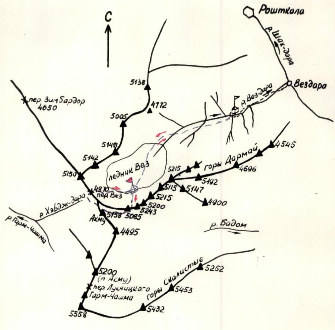
Map of Vez-Dara, South-West Pamir
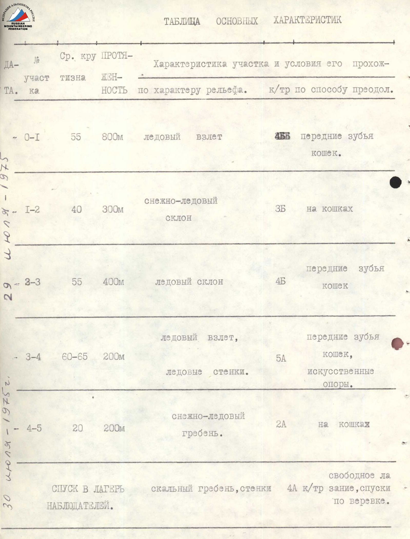
Table of Main Characteristics of the Ascent Route to Peak 5080
| Section | Avg. Steepness | Length | Characteristics of the Section and Conditions of its Passage. k/tr by method of overcoming | Weather | Time of Departure, Stops, Climbing Hours | Pitons Hammered (rock) | Pitons Hammered (ice) | Overnight Stay Conditions |
|---|---|---|---|---|---|---|---|---|
| R0–R1 | 55° | 800 m | Ice ascent. 4. Front teeth of crampons. | Clear | Departure — 5:00. Climbing hours — 6. | 60 pcs. | ||
| R1–R2 | 40° | 300 m | Snow-ice slope. 3. On crampons. | Clear | Climbing hours — 1. | 12 pcs. | ||
| R2–R3 | 55° | 400 m | Ice slope. 4. Front teeth of crampons. | Clear | Climbing hours — 3. | 30 pcs. | ||
| R3–R4 | 60–65° | 200 m | Ice ascent, ice walls. 5. Front teeth of crampons, artificial supports. | Clear | Climbing hours — 4. Stop at 19:00. | 24 pcs. | Overnight stay on the saddle | |
| R4–R5 | 20° | 200 m | Snow-ice ridge. 2. On crampons. | Clear | Climbing hours — 0 h 30 min. | |||
| Descent to observers' camp | Rocky ridge, walls. 4A cat. diff. Rope descents. | Clear | Climbing hours — 5. | 8 pcs. | ||||
| Total: | 1900 m | 8 pcs. | 126 pcs. |