
Ukrainian SSR Climbing Championship 1986 First Ascent Category
REPORT
on the ascent to Peak Shater 5568 m via the right part of the NW wall, 5B category of complexity (first ascent) by the team from Kharkov Regional Sports Committee.
Team Leader: Tanets A.A. Team Coach: Artemenko G.P.
310003 Kharkov, Palace of Labor Kharkov Regional Council of the "Burevestnik" Sports Society
310121 Kharkov 68A, Heroes of Labor St., apt. 34. Tanets A.A.
310023 Kharkov 8, Krasnoye Studenychestvo entrance. Artemenko G.P.
Elevations on the route were determined using a map and an altimeter 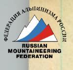
Participants:
- A. Tanets
- V. Buryak
- A. Elkov
- B. Polyakovsky
- V. Rybchenko (x.6)
July 12-18, 1986

Profile of the wall from the right
--- Route of ascent
Photo taken on July 29, 1986, 15:00
from the NW ridge of Peak Tri Bashni, distance 3 km
Lens #3, T-22, 50 mm
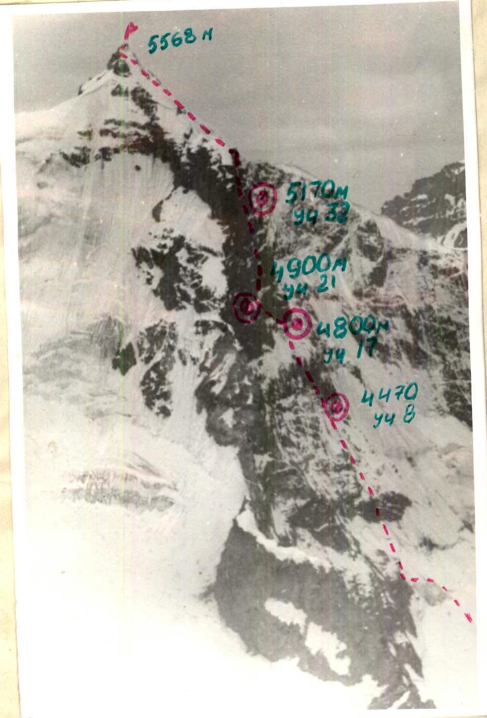
Profile of the wall from the left
--- Route of ascent
Photo taken on July 26, 1986, 16:00
from Pass Akmuy 5124 m, distance 10 km.
Lens Helios 50 mm #2
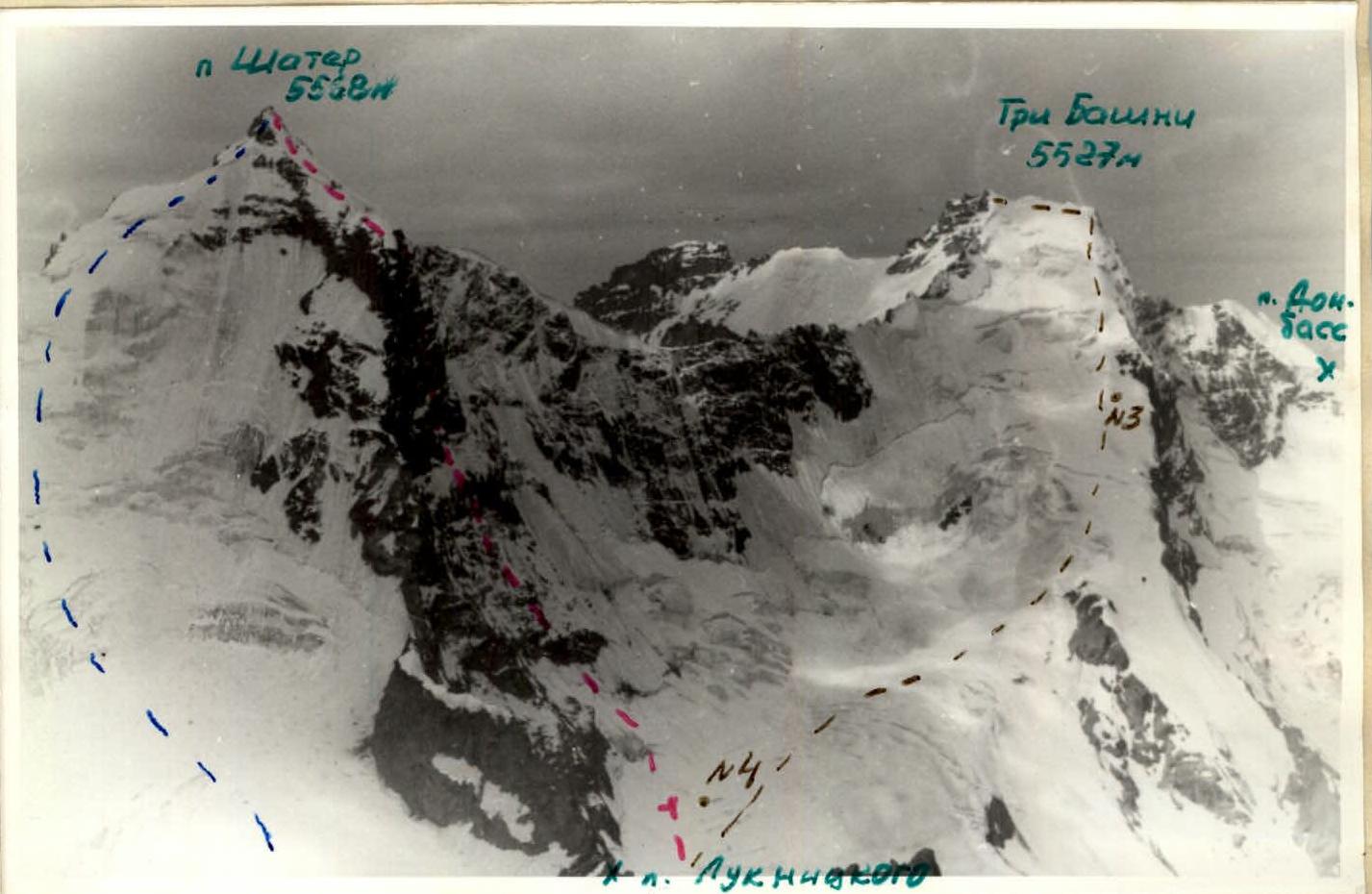
Panoramic photo of the area
--- Route of ascent --- Route 3-A category (descent route) --- Route 3-A category to Peak Tri Bashni
Photo taken on July 26, 1986, 16:00 from Peak Arm 5214 m distance 10 km, lens Helios 50 mm #2
- #3, 4 photo shooting points
Drawn route. Scale 1:5000 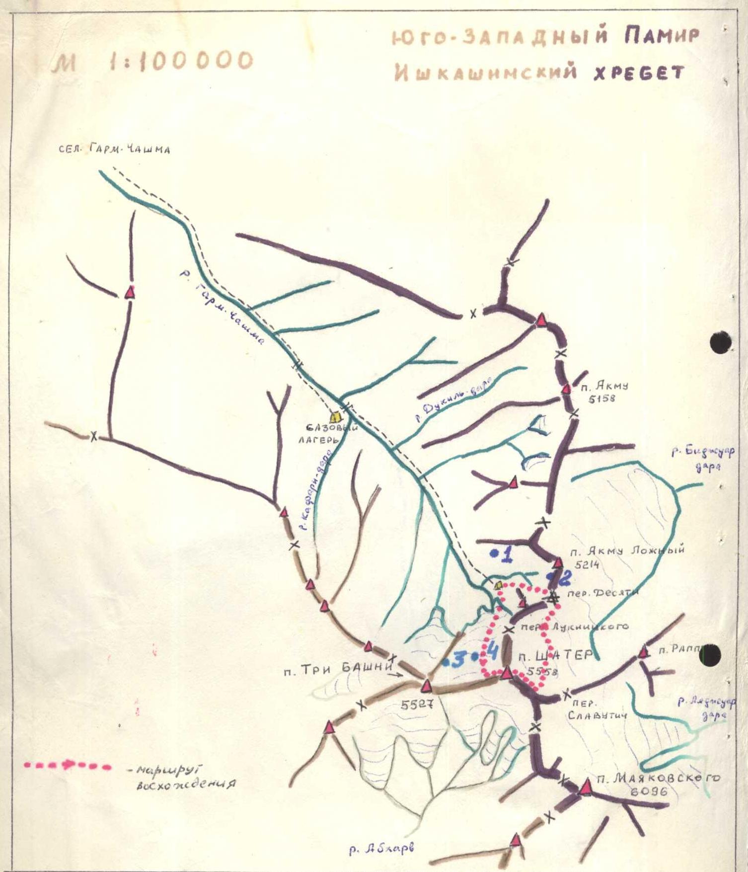
Map-scheme of the climbing area • #1, 2, 3, 4 – photo shooting locations
Brief overview of the climbing area
Peak Shater is located in the Shakhdarin Ridge of the South-West Pamir. 30 km from the Khorog-Osh highway to the village of Anderob, then 10 km left to the village of Garm-Chashma. From the village, follow the trail up the Garm-Chashma valley to the glacier of the same name, about 25 km, from where it's a 2-hour walk to the NW wall of Peak Shater. The approach from Garm-Chashma to the routes on the NW wall of Peak Shater takes 10-12 hours. The base camp can be conveniently set up on green meadows above the two koshi located on both sides of the river. From this location, it takes 4-5 hours to reach the wall.
In 1973, a team from Kharkov led by Gr. Prigoda won gold medals at the USSR Championship for their ascent of the NW wall of Peak Shater. After that, the Garm-Chashma valley was not visited by climbers for a long time. Last year, Leningrad climbers made two first ascents on Peak Shater via the NW wall: Balyberdin 6B category and Zhak 5B category, as well as several first ascents of 3-5 categories.
Participants of our expedition (July 3-30, 1986) repeated almost all the routes made by the Leningraders, and also made first ascents of approximately 3B, 4A, 4B, and two 5B categories. Thus, the area around Peak Shater has a sufficient number of routes for climbers of any level.
Preparation for the ascent
Our team received consultation on the area and a photograph of Peak Shater from Yu. Grigorenko-Prigoda. Peak Shater had been attracting our attention for several years, and we planned to make a first ascent via the NW wall. However, in 1985, Leningraders established two interesting routes - through the center and left part of the NW wall of Peak Shater. After analyzing the photograph with all the routes marked, our team concluded that another logical and relatively safe route of 5-6 categories could be established on the right part of the NW wall. Having entered the NW wall of Peak Shater in the Ukrainian SSR Climbing Championship in the first ascent category for 1986, our team began targeted training starting from the fall of 1985, according to a plan approved by the coaching council. The main focus was on:
- technical and physical preparation,
- selection of equipment.
Physical qualities were improved during training sessions (4 times a week) and participation in competitions. Team members improved their rock climbing technique in Crimea, participating in the championship of the regional council and the city of Kharkov in rock climbing.
In the winter, all team members conducted a training camp at the "Torpedo" alpine camp, making ascents to Peak Khitsan (3B category) and Peak Uilpa (5B category). In May, a two-week training camp was held in Crimea, where team members practiced working in rope teams on complex terrain, tested equipment, and made ascents. The tactical plan was developed based on an analysis of previous teams' ascents on Peak Shater, as well as the availability of equipment and team strength. The main initial data for the route were:
- a) alternation of steep sections (5 bastions) with simpler ones;
- b) possibility of organizing safe and convenient overnight stays between bastions;
- c) height difference of the wall section of the route: 1000-1200 m;
- d) possible steep and heavily destroyed rock sections;
- e) glaciation of the 1st and 3rd bastions;
- f) the wall is sunlit in the second half of the day.
Preliminary processing of bastions and overnight stays in protected areas were planned. In the morning, the team would ascend using ropes, then a two- or three-person team would process the area for the overnight stay, and the leading two-person team would set up ropes. Heavily destroyed sections were planned to be traversed using ropes, on a double rope, with intervals. To overcome icy sections, the team planned to use:
- ice axes
- crampons
Directly at the base camp, team members passed physical bracing tests and selected 5 participants for the ascent from among those registered.
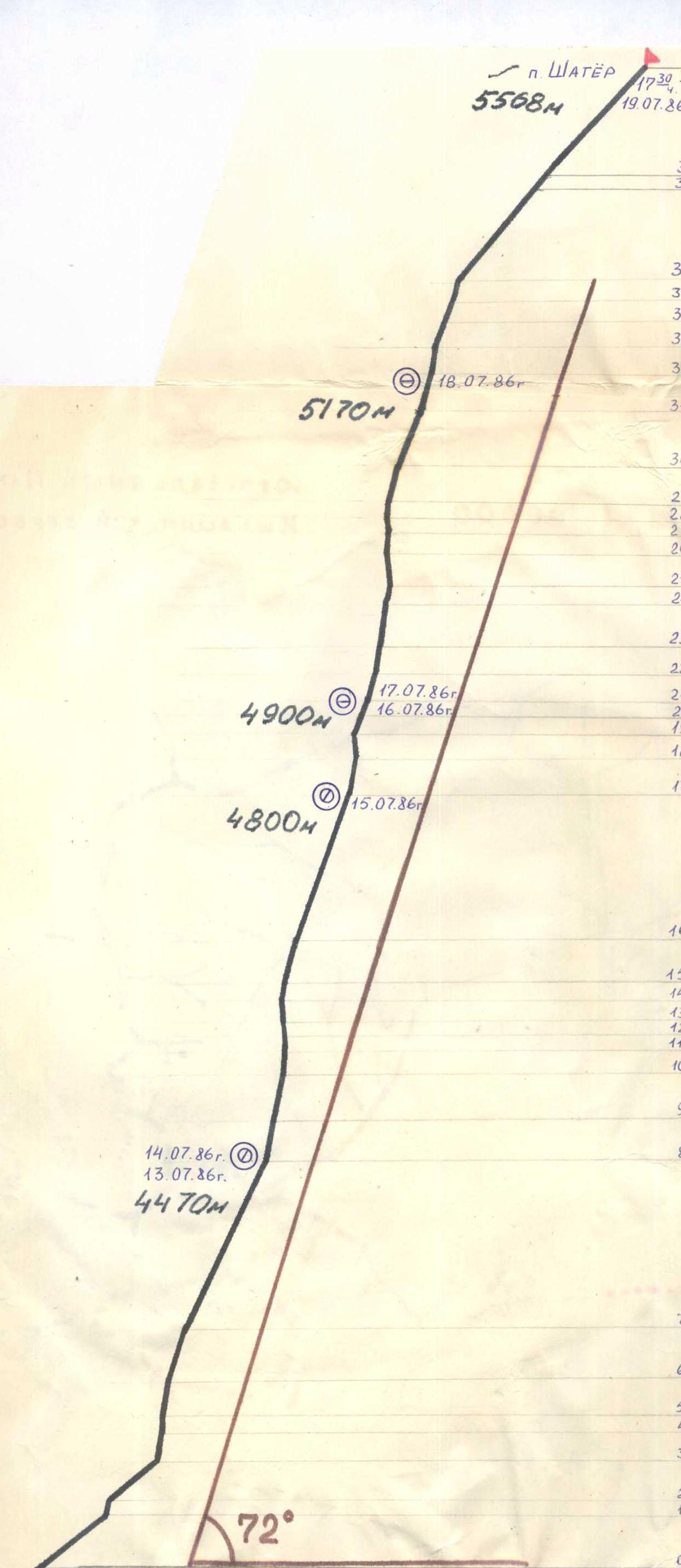
Ascent schedule
![img-6.jpeg]{"width":1535,"height":1276,"format":"Jpeg","uri":"https://summitx.info/media/1/TrSqTYbIVAHqkYmrsgr3xYkxn4tLpo7C/img-6.jpeg","id":64766549} ↗)
Ascent schedule
Time: 7:00, July 12, 1986 – Cloudy, no precipitation. Overnight stay #1: sitting in a tent, pole with snow. Overnight stay #2: lying in a tent.
July 13, 1986 – Cloudy, wet snow. Descent to the previous overnight stay.
July 14, 1986 – Cloudy, heavy wet snow starting at 14:00. Descent to the previous overnight stay. Overnight stay #4: lying in a tent, on snow under an overhanging wall at 4900 m.
July 15, 1986 – Fog, snow, strong wind. After 15:00, cloudy, no precipitation. Overnight stay #5 at an intermediate location.
July 16, 1986 – Cloudy, no precipitation.
July 17, 1986 – Snowy ridge at 5170 m. Overnight stay #6: lying in a tent.
July 18, 1986 – Fog until 15:00, wet snow, earthquake. Overnight stay #7 during descent, 1 hour from the summit. At 17:30, the group reached the summit.
Tactical actions of the team
The movement along the route followed a pattern: the leading two-person team (first with a lightened backpack or without one) would set up ropes, and the last person would remove pitons, take down the ropes, which were then passed forward, and so on. The team worked in this manner on sections: R0-R7, R15-R16, R29-R39. The rest of the route was preliminarily processed by a two-person team, while the others organized the overnight stay. Movement along the ropes mostly occurred in the morning, processing - in the second half of the day when it became significantly warmer. The composition of the rope teams changed, or rather, the leader changed, while the others moved along the ropes (necessarily on a double rope: either double ropes or ropes with insurance).
Initially, all team members worked as leaders:
- R0-R2 – Elkov
- R3-R5 – Tanets
- R6-R8 – Buryak
- R9-R13 – Tanets
- R12-R14 – Rybchenko
- R15-R16 – Polyakovsky
- R17-R19 – Tanets
- R20-R21 – Buryak
- R22-R23 – Rybchenko
- R24-R26 – Tanets
- R27-R29 – Rybchenko
- R30-R36 – Polyakovsky
- R38-R39 – Elkov
Movement began at 10:00 AM: a lot of time was spent on preparing food and gathering the five-person team in the tent. Work was completed by 19:00-21:00. A significant amount of time was spent on organizing overnight stays:
- the tent was set up on a prepared platform, in a protected location,
- reliable ropes were organized.
The team used a self-made, lightweight tent with a semicircular roof, which proved to be effective.
The first person ascended in galoshes on a double rope, one of which was "Elita" 11 mm with a UIAA stamp. As a rope for the ascent, a domestic-made rope was used. There were no falls or injuries. Food was prepared twice a day - in the morning and evening. Additionally, each participant received a package with snacks. Provisions and fuel were taken on the route with a reserve, which proved to be useful as the ascent was delayed due to bad weather.
Significant changes to the compiled tactical plan were brought about by the bad weather. In fact, only the first day had normal weather; subsequently, the team encountered:
- snow,
- wind,
- limited visibility.
The team waited for weather improvement every day, but it did not come, which is unusual for the South-West Pamir. The team had to wait out the bad weather in the tent: on July 13 until 12:30, on July 15 until 14:00, on July 16 until 15:00. During the remaining time, the team worked in difficult conditions. Limited illumination did not allow for high-quality photographs on the route.
Radio communication with the base camp was maintained using a "Karat" radio station and was stable throughout the entire ascent period ![img-7.jpeg]{"width":1432,"height":2079,"format":"Jpeg","uri":"https://summitx.info/media/1/kwCwkn79Ime69iqEHt4OoXzjM2edSDNG/img-7.jpeg","id":64766550} ↗)
| Pitons (rock, nut, shлямb., ice) | Length | Steepness | Category of difficulty | Section # | Notes |
|---|---|---|---|---|---|
| 4 rock, 4 nut | 40 m | 75° | 8 | 8 | |
| 18 rock, 6 nut | 180 m | 65° | 4 | 7 | 62 pitons, 12 hours |
| 4 rock, 3 nut | 40 m | 75° | 5 | 6 | |
| 6 rock, 4 nut | 40 m | 80° | 5 | 5 | Traverse left 5 m, pendulum 4 m |
| 4 rock, 1 nut, 1 shлямb. | 10 m | 92° | 6 | 4 | |
| 6 rock, 1 nut, 1 shлямb. | 30 m | 80° | 6 | 3 | |
| 4 ice | 60 m | 40° | 4 | 2 | |
| 3 shлямb. | 4 m | 90° | 5 | 1 | |
| 2 ice | 80 m | 35° | 3 | 0 | |
| 2 rock, 1 nut, 1 shлямb., 1 ice | 10 m | 90° | 6 | 28 | Large cornice |
| 2 rock, 2 nut | 15 m | 85° | 5 | 27 | |
| 8 rock, 6 nut, 3 shлямb., 4 ice | 25 m | 95° | 6 | 26 | |
| 3 rock, 2 nut | 15 m | 80° | 5 | 25 | Pendulum 8 m |
| 4 rock, 2 nut, 3 shлямb. | 20 m | 85° | 6 | 24 | |
| 4 rock, 1 nut | 15 m | 80° | 5 | 23 | |
| 2 rock, 4 nut | 25 m | 80° | 5 | 22 | 28 pitons, 5 hours |
| 2 rock, 2 nut | 30 m | 70° | 4 | 21 | July 16, 1986, July 17, 1986, Traverse right 20 m |
| 2 rock, 1 nut | 15 m | 60° | 3 | 20 | 2 cairns |
| 3 rock, 3 nut | 15 m | 20° | 5 | 19 | |
| 5 rock, 1 nut, 3 shлямb. | 20 m | 95° | 6 | 18 | |
| 5 rock, 1 nut, 2 shлямb. | 35 m | 80° | 5 | 17 | Traverse left 10 m, July 15, 1986 |
| 17 rock, 11 nut | 150 m | 70° | 4 | 16 | 75 pitons, 8 hours |
| 3 rock, 2 nut | 40 m | 75° | 5 | 15 | |
| 2 rock, 2 nut | 15 m | 85° | 5 | 14 | 7 hours 30 minutes |
| 3 rock, 4 nut, 4 shлямb., 3 ice | 20 m | 90° | 6 | 13 | |
| 3 rock, 2 nut, 3 shлямb., 5 ice | 15 m | 100° | 6 | 12 | |
| 2 rock, 2 nut | 10 m | 85° | 5 | 11 | |
| 2 rock, 2 nut | 15 m | 85° | 5 | 10 | |
| 5 rock, 6 nut | 40 m | 80° | 5 | 9 | |
| 4 rock | 250 m | 50° | 3 | 39 | July 18, 1986, 17:30, 28 pitons, 7 hours |
| 1 rock | 30 m | 55° | 5 | 38 | |
| 2 rock | 120 m | 50° | 3 | 37 | "Zhendarmer" |
| 4 rock, 4 nut | 30 m | 75° | 5 | 36 | |
| 4 rock, 4 nut | 20 m | 75° | 5 | 35 | |
| 3 rock, 2 nut | 20 m | 75° | 5 | 34 | |
| 4 rock, 4 nut | 25 m | 80° | 5 | 33 | July 18, 1986, 77 pitons, 10 hours, 3 cairns |
| 6 rock, 4 nut | 40 m | 70° | 4 | 32 | Traverse left 15 m |
| 8 rock, 5 nut | 60 m | 70° | 5 | 31 | |
| 6 rock, 3 nut | 40 m | 75° | 5 | 30 | |
| 3 rock, 1 nut | 15 m | 85° | 5 | 29 |
![img-8.jpeg]{"width":1434,"height":2146,"format":"Jpeg","uri":"https://summitx.info/media/1/hVyFdYszxy8i8GbvShSVZisaxYGzMLnp/img-8.jpeg","id":64766551} ↗)
Description of the route by sections
The route can be conditionally divided into five bastions, separated by snow-covered rocks of lesser steepness, with couloirs on both sides. These couloirs mark the counterfort along which the route is laid. The route follows the right edge of the NW wall. The left couloir separates our route from Gr. Prigoda's counterfort. To the right of the route lies a giant snow-ice couloir where rocks and avalanches continuously fall.
The approach to the first bastion (sect. #0-2) is via a snow-ice slope, the steepness of which gradually increases. The bergschrund is crossed at its narrowest point. Movement is in crampons, with insurance via ice screws.
The first bastion (sect. 3-5), approximately 80 m long, consists of steep, destroyed rocks covered with rimed ice. The beginning of the route follows an internal angle (sect. 3), then moves right under an overhanging section of frozen stones, which is overcome with the help of artificial aids (I.T.O.). Then follows an ascent onto an ice-covered inclined shelf. Upward to the left along a steep wall with ice (sect. 5). Exit to the top of the bastion. When passing through the first bastion, the leader used an ice axe and crampons.
The section (6-7), approximately 200 m long, is traversed vertically upward. The ascent leads to the base of the second bastion. Here, a sitting overnight stay is organized on a narrow shelf.
The second bastion (sect. 9-14) has an extensive overhanging section (12-13) and consists of destroyed rocks, the passage of which requires significant physical and mental tension.
After the overnight stay, two steep ropes (sect. 8, 9) lead left-upward to a small ledge, left of the overhanging section. From the ledge, straight up the wall, then along a crack (sect. 11) under the overhang. A pendulum swing of 8 m to the right under a cornice, which is overcome using I.T.O. Further, very destroyed rocks ("Rockfall!") are traversed on ladders to an inclined shelf. Left, a steep chimney (sect. 14) leads to a convenient shelf.
Along rocks of medium complexity, about 200 m (sect. 15-16), the team approaches the third bastion. The third bastion (sect. 18-20) is covered with rimed ice in its lower part and slightly overhangs in its upper part (sect. 18). In the second half of the day, the rocks are wet, and water flows. From the overnight stay, right-upward, then traverse left (sect. 18), and enter an internal angle (sect. 17). Further, straight up to a snowy ridge (sect. 20) and along it to the left under the wall - a convenient place for an overnight stay. From here, right-upward (sect. 21), bypassing smooth overhanging rocks, the team reaches a wall similar to an open book, crowned by a giant cornice - the key point of the route.
The fourth bastion (sect. 22-29) consists of monolithic dry rocks and is approximately 140 m long. Initially, the path follows a crack, then right along a steep wall with micro-ledges (sect. 23). The landmark is a small shelf where an overnight stay can be organized.
From the shelf, left into an internal angle (sect. 24), then pendulum swing into a steep crack (sect. 25), and along it, veering left to the edge of the giant cornice. The cornice is bypassed on the left using I.T.O. (sect. 28). Further, right-upward along a steep wall, exit to a convenient platform (sect. 29).
The fourth bastion required the use of many technical means: pendulum swing, étrier ascent, and hammering in shлямbur pitons, as well as the effective use of nuts, boxes, and thin wedges. From the platform, left into a chimney (sect. 30), then along small walls alternating with snowy sections, the team approaches (sect. 31-32) and exits onto a narrow snowy ridge leading left to the base of the fifth bastion.
The fifth bastion is traversed "head-on" by free climbing. Initially, along a steep wall entering a chimney, then along a crack (sect. 35), along a wall with small holds, exit to the "roof". Left along a snowy ridge (sect. 37) to a "zhendarmer", which is bypassed on the right, and further along the ridge to the summit, about 250 m.
![img-9.jpeg]{"width":1431,"height":2060,"format":"Jpeg","uri":"https://summitx.info/media/1/RIHsijVL0ndEH3GOM0s0ZqeEBdnoIY3O/img-9.jpeg","id":64766552} ↗)
Technical photography of the route
--- Route of ascent Photo taken on July 29, 1986, 17:00 from Garm-Chashma glacier distance 500 m, #4 lens T-22, 50 mm. --- Route of Grigorenko – sc/tr ![img-10.jpeg]{"width":150,"height":252,"format":"Jpeg","uri":"https://summitx.info/media/1/Izfsol5tWroBd0mAn2c84jbruUXOeSqj/img-10.jpeg","id":64766553} ↗)
Section #9
![img-11.jpeg]{"width":150,"height":256,"format":"Jpeg","uri":"https://summitx.info/media/1/PFPQN7zse0JISVGme8tAzzW1zlr6BBSb/img-11.jpeg","id":64766554} ↗)
![img-12.jpeg]{"width":914,"height":1385,"format":"Jpeg","uri":"https://summitx.info/media/1/J0hKaUw1kOtfKm0237iBmzzVvEPcT2oe/img-12.jpeg","id":64766555)} ↗
Section #13
![img-13.jpeg]{"width":150,"height":256,"format":"Jpeg","uri":"https://summitx.info/media/1/kUDG9jDCQU2NpfapUnowfCUTrqfAxYY1/img-13.jpeg","id":64766556} ↗) ![img-14.jpeg]{"width":906,"height":1413,"format":"Jpeg","uri":"https://summitx.info/media/1/B7j87nXr4xKEmxJwOuJC7Bfh619jykhR/img-14.jpeg","id":64766557} ↗)
Comments
Sign in to leave a comment