Passport
Route to Petrovsky Peak via the Western Horseshoe (Category 3B)
- Type of ascent — technical.
- Region — spur of the Trans-Alai Range north of Lenin Peak.
- Summit — Petrovsky Peak, 4700 m.
- Proposed category of difficulty — 3B.
- Route characteristics — total elevation gain about 500 m, average steepness about 15°.
- Number of pitons hammered in for protection — 13 pieces.
- Number of walking hours — 14 hours.
- Number of nights spent — one.
- Leader — Pavlenko A.M.
Team members:
- Galkina V.F.
- Faddeev M.A.
- Pavelyev D.G.
- Chochia P.N.
- Team coach — Ovchinnikov A.G.
- Departure date — June 30, 1980, return date — July 1, 1980.
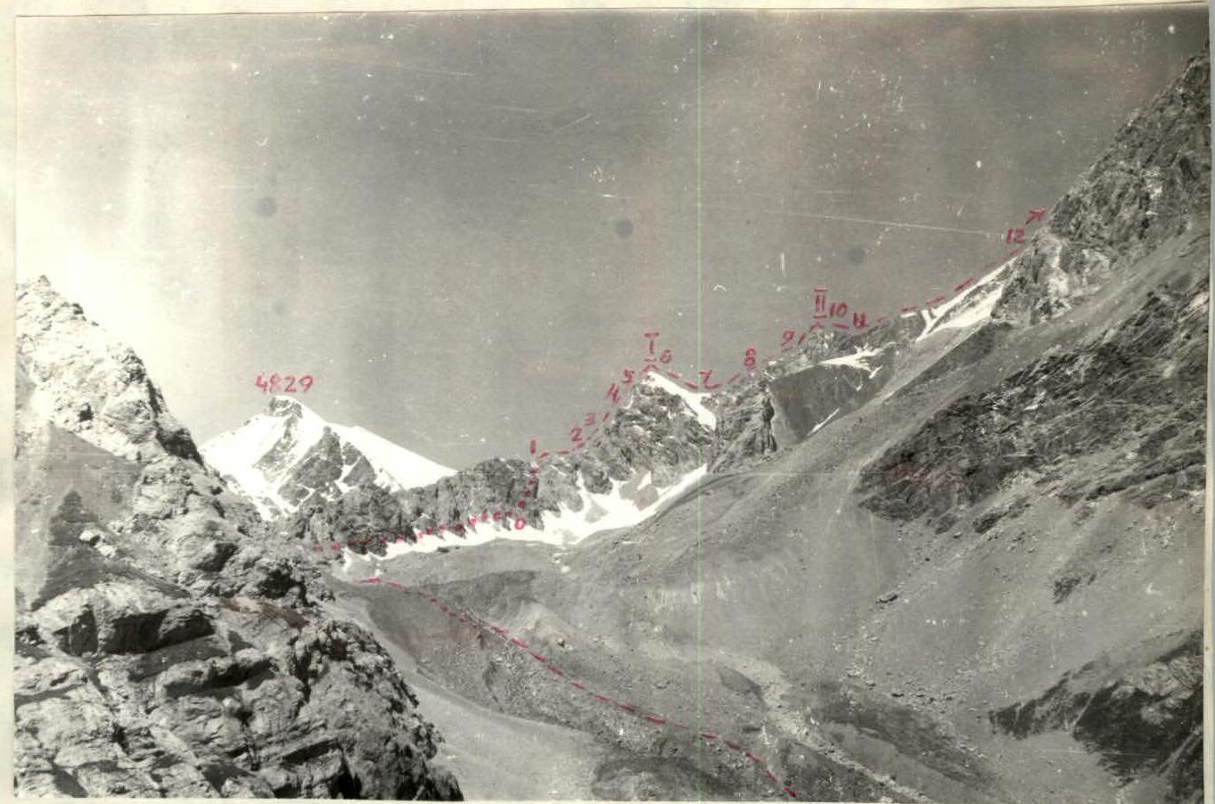
View of the route from Lukovaya Polyana.
 Map of the area around Petrovsky Peak.
Description of the approach to the route
From the "Pamir" base camp by car to Lukovaya Polyana. When approaching the clearing, the "saw-like" ridge of the route is clearly visible, seemingly leading up to Petrovsky Peak.
From the clearing:
- descend downwards;
- cross the stream;
- ascend along the scree slopes along the right bank of the stream, which originates from the glacier located under the peak 4829 m (see map).
Further:
- move along the moraines to the base of the rocky ridge of the western horseshoe;
- bypass the beginning of the ridge on the left along scree-covered, snowy ledges to an excellent platform between large rocky boulders, serving as the overnight camp site. From Lukovaya Polyana — 2 hours 30 minutes.
From the overnight stay:
- ascend upwards along snowy fields,
- about 300 m before reaching the col before the steep ridge of the 1st gendarme — 20 minutes.
The beginning of the route — ascend to the right and upwards onto the ridge along snowy slopes.
Route log (Category 3B, Petrovsky Peak)
Date: July 1, 1980. Weather: excellent.
| Section | Steepness | Length (m) | Terrain characteristics | Difficulty | Condition | Number of pitons |
|---|---|---|---|---|---|---|
| R0–R1 | 45–50 | 80 | Snow slope. | 2B | firm snow. | |
| R1–R2 | 0 | 120 | Rocky ridge. | 3B | broken | outcrops |
| R2–R3 | 50 | 40 | Rocky edge. | 4B | slabs | 3 |
| R3–R4 | 50 | 40 | Rocky edge. | 4B | slabs | 4 |
| R4–R5 | 35–40 | 120 | Rocky ridge. | 3A | broken | outcrops |
| R5–R6 | 40 | 40 | Rocky ridge. | 3B | broken | 2 |
| R6–R7 | 45–30 | 100 | Snow ridge. | 2A | snow | |
| R7–R8 | 0 | 120 | Snow ridge. | 1B | snow | |
| R8–R9 | 20–25 | 300 | Rocky ridge. | 2B | broken | outcrops |
| R9–R10 | 40–45 | 150 | Rocky ridge. | 3B | broken | 4 |
| R10–R11 | 45 | 80 | Snow ridge. | 2B | snow | |
| R11–R12 | 0 | 1500 | Ridge. | 1B | snow, rocks, scree | |
| R12–R13 | 30 | 200 | Snow ridge. | 1B | snow |
Notes on route sections
R1–R2: There are two sports-style vertical descents of 6 and 8 m. In the second case, a loop made of a main rope is left behind.
R3–R4: There is a 2.5 m vertical wall with a crack.
R5–R6: Ascent to the summit of the first gendarme through a 1 m snow cornice.
R6–R7: On descending from the first gendarme, there are hidden crevasses and a cornice on the right-hand side.
R9–R10: Ascent to the summit of the second gendarme.
R10–R11: On descending, there are crevasses and cornices.
R11–R12: A long horseshoe-shaped ridge with cornices sometimes on the right, sometimes on the left, featuring five rises with an average elevation gain of 50 m.
R12–R13: Ascent to the summit of Petrovsky Peak. Descent from the summit follows a Category 1B route.