Climbing Passport
- MOUNTAIN ASCENT TYPE: HIGH-ALTITUDE TECHNICAL
- ASCENT REGION: PAMIR, DARVAZ RANGE SPUR
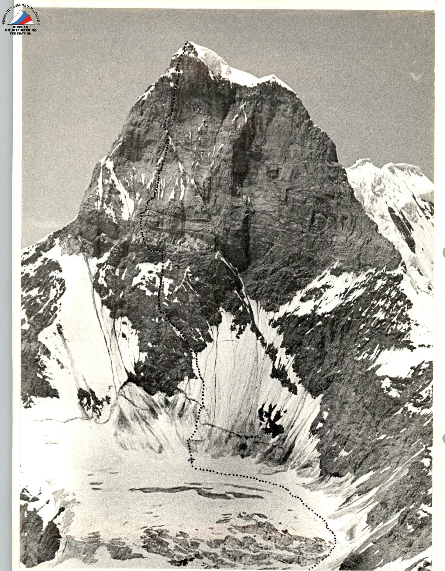
- PEAK, HEIGHT, ASCENT ROUTE: PIK SOVIETSKAYA UKRAINE, 5764 m, via the Eastern wall from L. Suraysh
- PROPOSED DIFFICULTY CATEGORY — 6B
- ROUTE CHARACTERISTICS: Height difference 1560 m. Length of sections with 5–6 category difficulty, 150 m, 415 m, 290 m, 545 m, 739 m. Average slope 70°.
- PITS SET: for belaying, for creating artificial anchors. Rock anchors 287 Ice anchors 51 Bolts 12
- TOTAL CLIMBING HOURS 92 hours
- NUMBER OF NIGHTS AND THEIR CHARACTERISTICS: 11 nights, 3 of them in hammocks
- Team members: Bershov Sergey Igorevich, Master of Sports, team leader; Monogarov Vladimir Dmitrievich, 3rd Master of Sports; Grigorenko-Prigoda Yury Ivanovich, Master of Sports; Tkachenko Vladimir Semenovich, Master of Sports; Bakhtigozin Vitaly Anatolyevich, Master of Sports; Polusokov Alexander Nikolaevich, Candidate for Master of Sports; Eremenko Grigory Nikolaevich, Candidate for Master of Sports; Pilipenko Vladislav Sergeevich, Candidate for Master of Sports
- Team Coach: Grigorenko-Prigoda Yu.I.
- Departure and return dates: July 18 — July 30
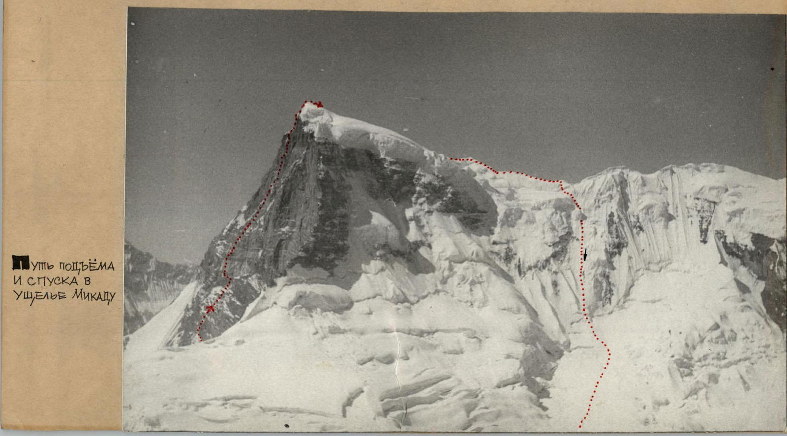
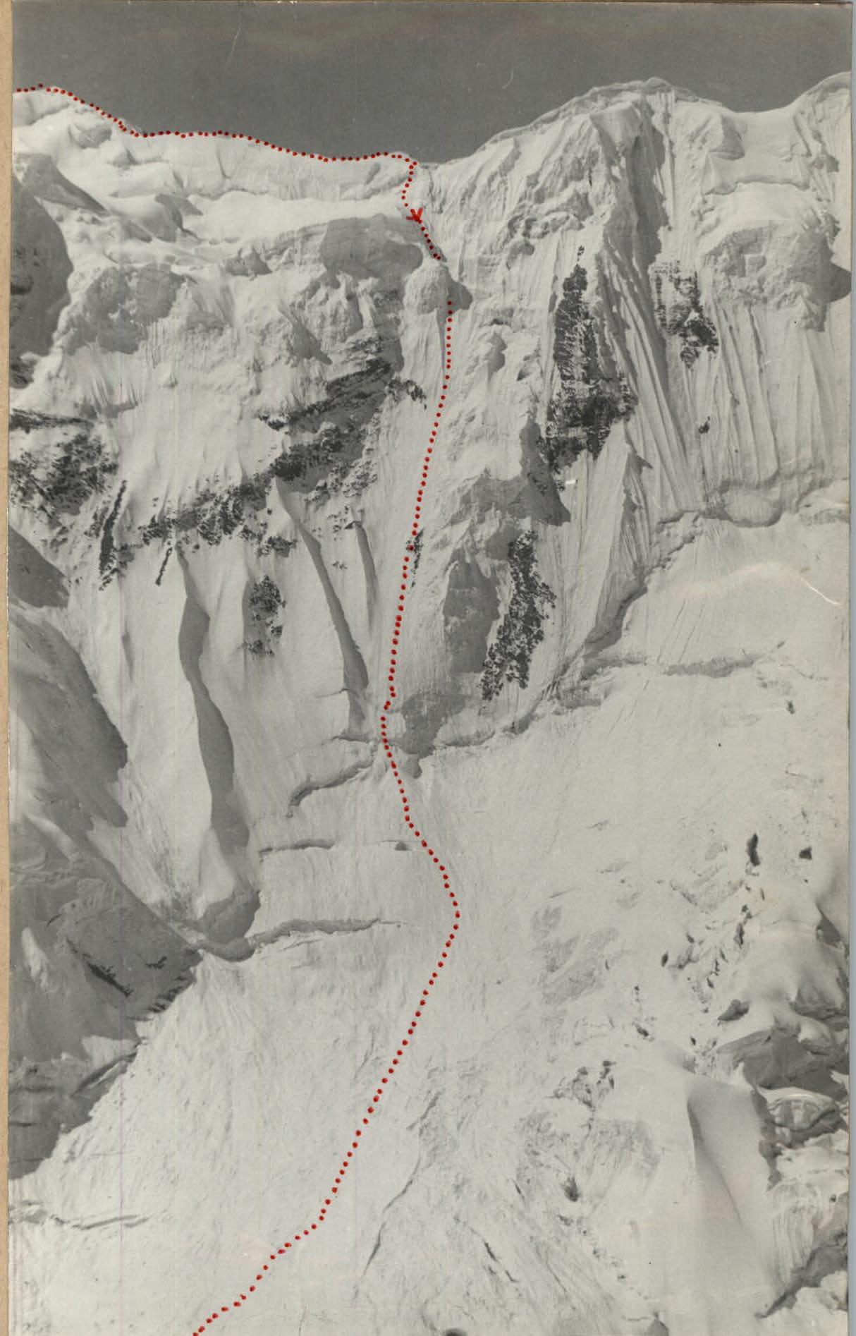
Descent route via the 700-meter northern wall to the Mikad glacier valley
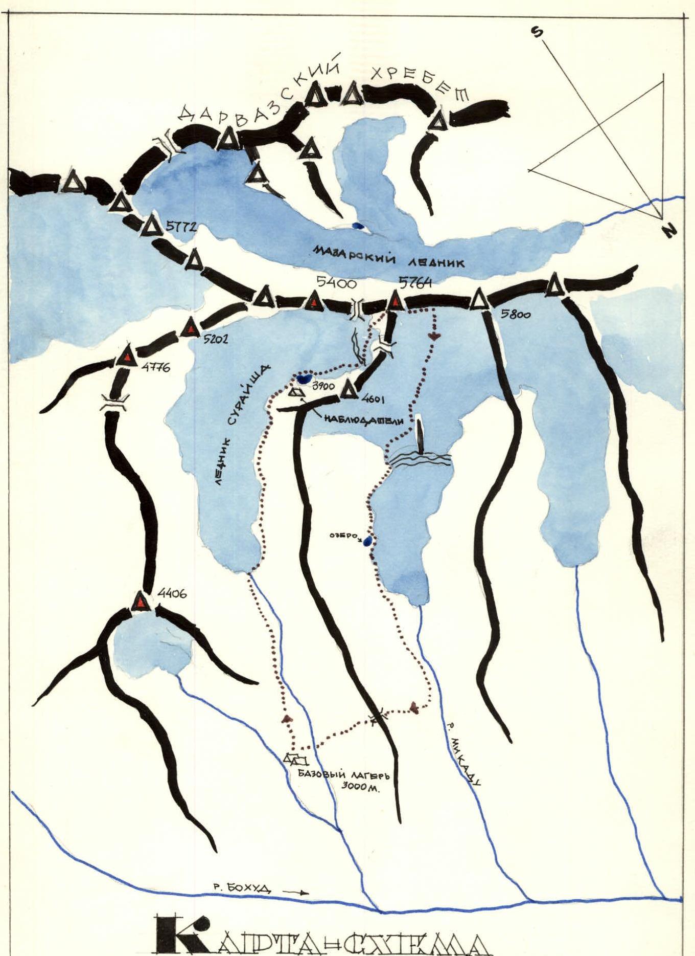
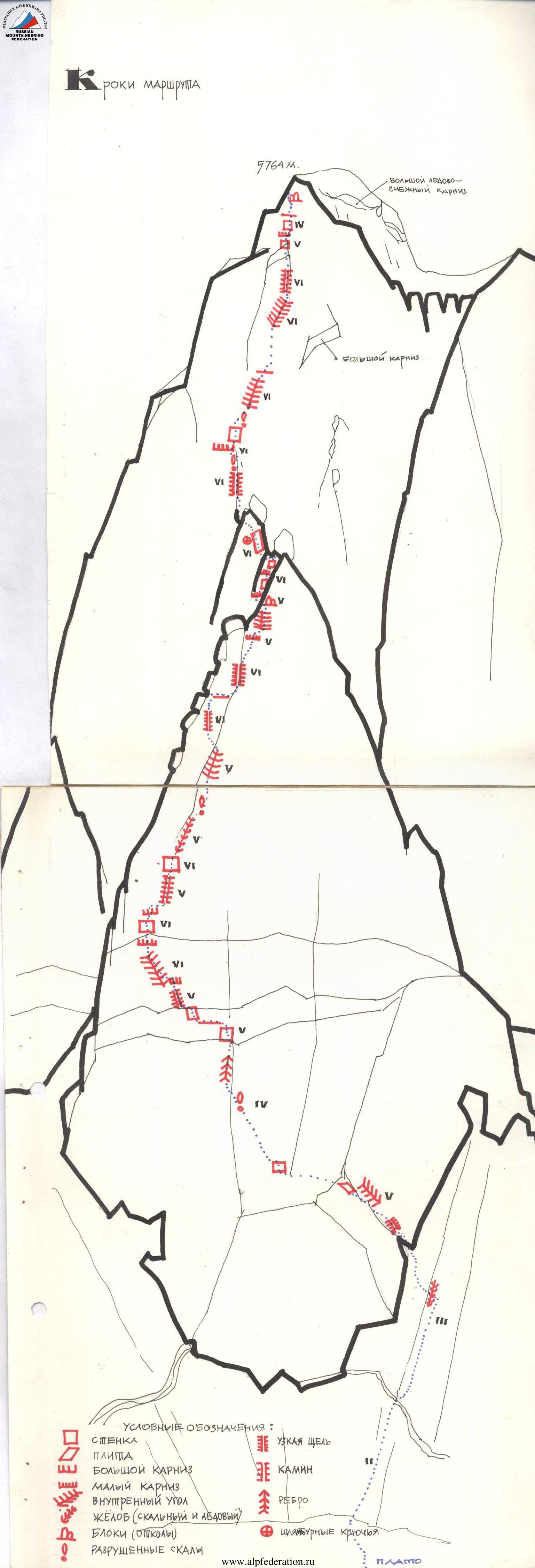
Map diagram
- Peaks with first ascents
- Team's path to peak 5764 m
- Passes
Physical and geographical characteristics of the region and its exploration history
Description of approaches to peak 5764 m
The Western Pamir relief is a system of high ridges separated by deep gorges. The contours of the mountains here are sharp and jagged, and the slopes are very steep.
In the latitudinal direction, the northern part of the Western Pamir is stretched by the ridges of Peter the First, Darvaz, and Vanch. To the east, they adjoin the meridional ridge of the Academy of Sciences, which separates the northwestern ridges of the Pamir highlands from the Fedchenko glacier system, also belonging to the Western Pamir. At the junction of the ridges of Peter the First, Darvaz, and the Academy of Sciences, the highest mountain node is located, including Peak Kommunizma (7495 m).
The southernmost link of the North-Western Pamir mountains is the Darvaz range, covering the approaches to the South-Western Pamir with a powerful icy wall. From Peak Garmo, where it adjoins the ridge of the Academy of Sciences, the Darvaz range stretches in a southwesterly direction.
The ridge part of the range goes in a curved line, bypassing the upper reaches of the large valleys of the rivers Bokhуд, Obi-Mazar, Darharvak. From the source of the Geographical Society glacier, the height of the ridge decreases from 6515 to 4500 m at the Abkh-i-Sitarhgi pass and again reaches 6080 m at Peak Arnavad. The transverse profile of the ridge is sharply asymmetrical: the slope facing south is steep and short; the opposite one is long and dissected by large valleys into spurs.
The northern slope of the Darvaz range has two large spurs: Pashimgar and Mazar. The Pashimgar ridge serves as a watershed between the Garmo and Bokhud rivers. Its average height is 4900 m.
The Mazar ridge stretches for more than 40 km and serves as a watershed between the Bokhud and Obi-Mazar rivers.
The mid-mountain relief of the watersheds, raised above the snow line, a wide network of deeply incised valleys, and large absolute heights create favorable conditions for the development of cirque and valley glaciers on the Darvaz range.
The Bokhud river, together with the Garmo and Kyrgyzob rivers, whose waters merge at the kishlak Pashimgar, give rise to the Obikhingou river. The Bokhud river originates from the northern slope of the Darvaz.
The history of Pamir exploration is very ancient. Mentions of it are found in the works of the Alexandrian geographer Claudius Ptolemy in the 2nd century. In the 7th century, the famous Buddhist preacher and traveler Xuanzang visited the Pamir, and at the end of the 13th century, the Venetian Marco Polo.
The actual study of the Pamir was started in the second half of the last century by Russian travelers N. A. Severtsov, I. V. Mushketov, A. P. Fedchenko, V. F. Oshanin, and others. A huge contribution to the study of the Pamir was made by Soviet scientists:
- N. L. Korzhenevsky
- O. I. Belyaev
- I. G. Dorofeev
- D. I. Shcherbakov
as well as leaders and participants of the first mountaineering ascents — O. Yu. Shmidt and N. V. Krylenko.
In sports terms, the Pamir as a whole is well developed. There are dozens of the most interesting mountaineering and tourist routes here. Most of them, due to the severity and inaccessibility of this mountainous country, are complex in nature. But not all corners of the Pamir and, in particular, the Western Pamir are known to athletes. In the immediate vicinity of such well-known areas as the eastern part of the Peter the First ridge, the basins of the Ganдо and Garmo glaciers, the Fedchenko glacier region, there are hundreds of kilometers of ridges, spurs, and mountain gorges that are extremely rarely or never visited by tourist and mountaineering groups.
A great contribution to the development of the Western Pamir was made by Kharkov mountaineers, who discovered and traversed more than 40 passes in the Darvaz range and its spurs.
The Western Pamir is being explored by mountaineers from high altitudes to low ones: Peak Garmo, Peak OGPU, Peak Pulkovskaya — peaks at the junction of the Darvaz and Academy of Sciences ridges. And in the Darvaz range itself, Peak Arnavad was conquered in 1957 by a group led by D. Medzmariashvili (Main Arnavad) and in 1974 by a group led by G. Chunovkin (North Arnavad).
Peak 5764 m is located in the Mazar ridge, which is a spur of the Darvaz range and has all the characteristics of the Darvaz range. The heights of the peaks in this area are about 5700–5800 meters.
The expedition's base camp was chosen in the Suraysh river valley (a tributary of the Bokhud river), 20 minutes walk from the Bokhud river valley. In the area of the base camp, there is an ivory grove, a warm lake, a clean stream, and many sites suitable for helicopter landing, abandoned summer camps.
From the base camp to the object of ascent, you need to go along the right orographic bank of the Suraysh river to the glacier — an exit to the plateau under the wall.
In 4–5 hours of walking from the base camp and in 1 hour of walking from the plateau under the wall on the moraine on the shore of a small lake, an intermediate camp was organized for observers.
Peak 5764 is a node of three ridges; it stands out sharply in the area because its walls abruptly break off to the Mazar, Suraysh, and Mirad glaciers.
Reconnaissance exits and overflights showed that there are no easy paths to the summit and from the summit.
The expedition members made 6 first ascents from 2nd to 6th category difficulty to the peaks in the area of Peak 5764. The main goal of these ascents is to observe the main object and explore the descent paths.
Description of the route passage by sections and by days
I-st day. July 18, 1977. Today we went on an ascent. Behind us is a 10-day gathering in the Caucasus, training ascents to Peak Shchurovsky and Elbrus, training ascents here in the Pamir, in the spur of the Darvaz range. Everything is behind us, only our peak is ahead of us — it is beautiful from this, eastern side, and from Peak Suraysh, from our camp by the lake — the observation camp. Long disputes about the options for ascending the eastern wall, observations, and again disputes, but they are also behind us — we are heading under the wall. A clear sunny day.
The path from the observation camp (4000 m) goes from the right part of the glacier with an exit through a small ice fall to the plateau under the wall. This is a 2-hour path from the camp at 4000 m.
We leave the camp at 8:00. We were on the plateau under the wall at 10:00. In front of us is a snow slope intersected by a bergschrund in the lower part and cut by deep grooves vertically.
Section R0–R1. 150 m, 45°
Avalanche debris with a traverse to the right under the bergschrund and crossing it along a snow bridge. Ahead is the Eremenko — Tkachenko rope team. Above the bergschrund, the slope becomes steeper, and you need to change the leading climber more often. The Bakhtigozin — Tolstousov rope team takes the lead.
Section R1–R2. 400 m, 50°
A steep snow-ice slope intersected by deep vertical grooves. At this site, we leave the hung ropes in place — we have a lot of cargo and need to shuttle, i.e., go down and pass this section repeatedly. Movement in the direction of the internal angle, which is clearly defined and visible. We approached the rocks, very destroyed at first.
Section R2–R3. 160 m, 70°
The Bershov — Tolstousov rope team takes the lead. A rather steep internal angle, wet in the first half of the day and with rimaye ice in the second. After 80 m — a small snowfield and higher on the exit to the site, where a bivouac is organized, ice. On this day, you can go higher, but we have a lot of cargo — you need to go down and repeat the path traveled along the hung ropes with cargo. At all sections of the route, the first rope team goes without backpacks.
Bivouac.
II-nd day. July 19, 1977. Very early. The sun illuminates our wall. Therefore, the ascent is at 6:00, departure is at 8:00.
Section R3–R4. 250 m, 45°
The Pilipenko — Eremenko rope team is ahead. The rocks are very destroyed. There are small rock walls. The belay is anchor. It seems that the yellow quartz belt is very close, below which the dark rocks are located, and their steepness is significant. This is, in fact, the beginning of the main wall of our peak. We look at the structure of the rocks, the stone breed — so far the picture is encouraging: large blocks, good cracks for anchors.
Section R4–R5. 60 m, 80°
Movement towards the talus shelf, which is guessed behind the bend of the 60-meter wall with an internal angle on the right along the course. The talus shelf is surprisingly sandy, which is not very reassuring because we remember 1976 and the route to peak 5300 m, from which our team descended — there was also a lot of sand. The shelf is on the right, near the snowfield, and is "shot" with stones. We move left and, after lengthy construction work, lay out two platforms for tents. Monogarov settled nearby, in a hammock — this is still possible because the days are warm, cloudless. We are under the quartz belt. Height 4900 m.
III-rd day. July 20, 1977. The whole day is devoted to filming. The Tkachenko — Tolstousov rope team, using the handrails left specifically for the operator's ascent, descended down and climbed up with the operator and equipment to the camp, where the characteristic moments of the difficult ascent of the team participating in the USSR Championship in mountaineering were filmed. By evening, the operator was lowered down, where he was met by Master of Sports D. Lavrenko and B. Shchekhovtsov (1st category). On the same day, all the handrails were removed below.
IV-th day. July 21, 1977. As always, we started work at 8:00. The Bershov — Tolstousov rope team came out.
Section R5–R6. 80 m, 80°
The first 40 m are passed by Sergey. The rocks are destroyed. The belay is anchor and through chocks. Nylon loops are used for offset from anchors. Having passed 40 m, on a glazed slab, in a "hang", we take Tolstousov and release him forward. The quartz belt is further strongly destroyed and steep. The good weather allows the rope team to go in light shoes, in galoshes. Using anchors and chocks, Tolstousov passes 40 m and reaches the black belt of rocks — the quartz belt is passed. The black rocks under the quartz belt have an excellent structure for a rock route — reliable footholds, breaks, cracks.
Section R6–R7. 40 m, 85–95°
Bershov is moving forward. The amazing structure of the rocks — after 10 m the rocks that so delighted us with their structure end, and a нависающий yellow belt begins, but not quartz, but sandstone, very soft and steep. The Carpathian rocks of Dovbush are reminiscent of these sections on the route. There are rock "ears" that Sergey uses, wrapping them with a cord loop, for intermediate belay. Bershov passes a very difficult section and, in a "hang", under the cornice, takes Tolstousov.
Section R7–R8. 50 m, 85–90°
And again, Bershov is ahead. Using ice anchors for belay (almost every 1.5 m), Sergey moves freely to the left, passes the cornice, and disappears behind the bend. Soon he takes the second climber. And only by going with top-rope along the path of the first, you can appreciate the complexity of the passed section — very steep, destroyed, soft rocks, sprinkled with sand. Under the cornice, on a slab, two bolts are hammered. To the right, ten meters away, there is a snow block — here you can organize a night's stay in hammocks. Under the cornice, a bivouac for three people is organized in hammocks.
And again, a cornice, which is passed by climbing, and an exit to the internal angle, the beginning of which is at a small wall, where the rope team leaves unused equipment (anchors, chocks, tapes, etc.). It's already late, and there is no place for the whole team to spend the night. We go down to the guys.
V-th day. July 22, 1977. On this day, we planned to reach the snow ridge on the left. The Tkachenko — Tolstousov rope team came out.
Section R8–R9. 20 m, 75°
The internal angle, wet rocks, is heavily destroyed, but early in the morning and in the second half of the day it is reinforced by frost. Climbing in light shoes. The belay is anchor; ice anchors are used.
Section R9–R10. 120 m, 75–80°
All the same internal angle, wet, there are no cracks for anchors. Very difficult climbing. A bolt is hammered for belay. We made a traverse to the left to the snow blocks on the ridge. Tkachenko tried to go out on the snow in crampons, but it is very steep, and the snow is firm, crumbly, and unreliable. We return to the internal angle again, which leads under the wall. The Bershov — Bakhtigozin rope team takes the lead.
Section R10–R11. 50 m, 85°
A 20-meter wall leads to a narrow shelf, where a night's stay is possible for 4 people. Further — a difficult traverse to the right, again into the internal angle, which turns into a chimney filled with ice and living stones. The belay is anchor and on chocks. At the end of 50 m, a bolt is hammered. Above the chimney hangs a snow block with icicles. We decide that the trio remains under the belt for the night. The camp is not removed due to the lack of safety of overnight stays for the whole team.
VI-th day. July 23, 1977. The Bershov — Tolstousov rope team continues to move up. The rest transfer cargo to the shelf and remove all the ropes below.
Section R11–R12. 40 m, 85–90°
The route passes under a hanging snow block. Danger! The rocks are steep and destroyed. Anchors and chocks are used. Movement along the wall to the right of the snow cornice, then the internal angle to a characteristic break in the form of a rhombus. Bershov is ahead. Having passed 40 m, we take Tolstousov and again he goes forward.
Section R12–R13. 30 m, 85–90°
Movement to the left on the buttress under the beveled cornice, which is passed in the left part. Again, we are amazed at Sergey's ability to calmly and technically pass difficult sections. Having passed the cornice, he takes Tolstousov. Bershov goes forward again.
Section R13–R14. 40 m, 85–90°
Movement along the wall, leading to the ridge, on the right — a huge snow drift, from under which water seeps along the rocks. The rocks are steep and soft, like sandstone. In the middle of the wall there is a meter-long cornice, which is passed in the right part. Before reaching the ridge, several anchors are hammered for artificial footholds.
We reached the ridge, and it seems that there is no further path:
- On the right — an almost sheer ice wall;
- On the left — a rock wall passed by us;
- On the ridge — a snow drift — steep and crumbly snow.
But it's time to descend to the bivouac, which is done by the Bershov — Tolstousov rope team. We spend the night on a shelf, where four people sit, the rest — in hammocks.
VII-th day. July 24, 1977. In the morning, sleet pours down the wall above the hammock and gets stuck between the wall and the hammock. The guys sleeping on the shelf sitting are already on their feet — they need to prepare breakfast. No clearing. It's snowing continuously. You can't see either the southern wall of Peak Kommunizma or Peak Moscow, which our Spartakovites are climbing from the north.
Section R14–R15. 20 m, 85°
The Tkachenko — Bakhtigozin rope team comes out. You need to pass the ridge and reach the top of the triangle, behind which a small ridge is guessed, on which you can make platforms for tents. The ropes hung yesterday are passed, and Volodya Tkachenko, using an ice axe, on the front teeth of crampons, passes the ice wall by traversing and approaches the base of a monolithic aiguille.
Section R15–R16. 30 m, 85–90°
The rocks on the aiguille are monolithic and without cracks. Two bolts are hammered for belay. Above, the rocks are covered with rimaye ice because there is a huge snow block on top of the aiguille.
Section R16–R17. 15 m, 45°
The ridge leading to the base of the chimney, which goes steeply upwards — this is already the pre-summit wall. At the base of the wall, after lengthy work, two platforms are made. The whole day it's sleeting. In a snowstorm, they transfer cargo and already in complete darkness, we settle in for the night. Very small platforms, so Volodya Tkachenko spends the night in a hammock and under a slab. A very tense day. We are glad that we have reached this place, where you can put up tents, where bad weather is not scary, which does not stop either day or night. Real winter in the middle of summer.
VIII-th day. July 25, 1977. It's still snowing. The rocks are very snowy. The foursome goes to remove the ropes that they did not have time to remove on the 24th. They didn't advance a single meter up. Time-out.
IX-th day. July 26, 1977. At night, a thunderstorm and snow — in such an amount that none of us has ever seen. Fought the snow, covering the tents. During the day, it's snowing and sleeting. The Bershov — Tolstousov rope team went on the route.
Section R17–R18. 30 m, 90°
From the tent, there is a chimney filled with ice and stones. Tolstousov is the first to go. There's a lot of snow that needs to be cleaned to free up the rocks and find cracks for anchors. 30 m have been passed. It's sleeting heavily and cold. On this day, they didn't pass anything else, but the meters traveled were encouraging — the hung rope went up to the summit.
X-th day. July 27, 1977. Sunny weather. The rocks are steep, and the snow doesn't stay on them for long in such weather. They left at 10:00. The Bershov — Tolstousov rope team comes out. Bershov goes first. Having passed the 30 m hung, Sergey puts on galoshes because the rocks are very steep and glazed.
Section R18–R19. 30 m, 85°
Movement towards the destroyed cornice along a crack, the edges of which are beveled and glazed. Sergey approaches the cornice and takes Tolstousov. A large destroyed cornice is in front of us. All the ice anchors are knocked out down there — only they are reliable in these cornices.
Section R19–R20. 25 m, 95°
This is the key section of the route. Using ice anchors and hanging three ladders, Sergey very slowly climbs up and disappears behind the bend. Soon, knocking out the anchors, Tolstousov approaches Bershov and goes forward.
Section R20–R21. 70 m, 85–90°
A wet internal angle, but in the second half of the day — rimaye ice. For belay, anchors and chocks are used. On all sections — movement only on a double rope. The internal angle leads to a small site with snowfields, and the guys begin to climb with backpacks along the fixed ropes to this shelf, where you can hang hammocks and there's snow. We somewhat force the ascent because the bad weather at 5400 m has redistributed a lot in terms of our food supply, which had to be significantly reduced.
On the same day, the R21–R22 section was passed and the rope was fixed.
Section R21–R22. 60 m, 85°
Movement along a vaguely expressed internal angle. The rocks are wet and destroyed. To the right is a huge rock cornice, somewhat reminiscent of the cornice on the northeast wall of North Ushba. To the left is a characteristic garland of icicles. There are so many of them on this wall.
XI-th day. July 28, 1977. On this day, we planned to reach the summit and spend the night there or near the summit. The Tkachenko — Tolstousov rope team is ahead.
Section R22–R23. 70 m, 85–90°
Movement along an internal angle close to a chimney. Rimaye ice, rocks are destroyed. The exit to the triangular snowfield is very difficult. Above the snowfield, the rocks become gentler and stronger, more reliable.
Section R23–R24. 130 m, 85–90°
Movement along the wall under the cornice, which has to be passed on the right, then along the crack along the slabs — an exit to the snow field lying under the summit rocks, or rather, rock blocks. The belay is anchor and through chocks.
Section R24–R25. 40 m, 70°
Movement along snow shelves, large blocks of stones with an ascent to the summit on the left.
And here is the summit. We hammer two bolts, fix the ropes, and warm up a bit in the rays of the setting sun, because our wall has long been in the shade. We descend to the guys on the snowfield, where two tents are already set up.
XII-th day. July 29, 1977. Bad weather in the morning. Cold, snow. We climb to the summit, leave a note, and, in the breaks of the clouds, catching the direction, we begin to descend along the western ridge. In the middle of the ridge, we turn north and descend down to the glacier along a very steep, 700-meter ice wall, leaving ice screws and loops. At 21:00 we were on the first median moraine, where we spend the night right on the moraine stones. The next day — descent along the glacier, crossing the pass to the base camp, and a meeting with those who were waiting for us and worrying about us for all these 12 days of ascent.
Table of main characteristics of the ascent route to peak 5764 via the Eastern wall
| Date | Passed sections | Average slope of the section | Length of the section (by length) | Characteristics of the section and passage conditions | By relief character | Category of difficulty | Weather conditions | Processing time | Anchors set | Rock | Ice | Bolts | Conditional overnight stay |
|---|---|---|---|---|---|---|---|---|---|---|---|---|---|
| 07.18 | R0–R1 | 40° | 150 | Snow slope | Snow slope | 2 | One-day, Sunny | Departure 8:00 | Overnight stay in tents, lying down | ||||
| 07.18 | R1–R2 | 50° | 400 | Snow-ice slope | Snow-ice slope | 3 | Sunny | End 18:00 | 3 | — | — | — | Overnight stay |
| 07.18 | R2–R3 | 70° | 160 | Internal rock angle, местами со снегом, с натечным льдом | Internal rock angle | 5 | Sunny | Climbing hours — 10 | 16 | 2 | 1 | — | — |
| 07.19 | R3–R4 | 45° | 250 | Rocky counterfort | Rocky counterfort | 4 | Cloudy, overcast | Departure 8:00, end 17:00 | 13 | — | — | — | Lying overnight stay in tents on a talus shelf |
| 07.19 | R4–R5 | 80° | 60 | Rocky wall | Rocky wall | 5 | Cloudy, overcast | Climbing hours — 9 | 11 | 3 | — | — | |
| 07.20 | Photo and film shooting | Lying overnight stay in a tent | |||||||||||
| 07.21 | R5–R6 | 85° | 80 | Destroyed rocky wall with a crack | Destroyed rocky wall | 4 | Cloudy | Departure 8:00, return 19:00, processing — 11 | 17 | 4 | 1 | — | Lying overnight stay in tents on a talus shelf |
| 07.21 | R6–R7 | 90° | 40 | Solid rocky wall | Solid rocky wall | 6 | Cloudy | — | 14 | 2 | — | — | |
| 07.22 | R7–R8 | 85–90° | 50 | Two cornices, destroyed, sandy wall | Two cornices | 5 | Cloudy | Departure 8:00, return 19:00, processing — 11 | 15 | 5 | — | — | Lying overnight stay in tents |
| 07.22 | R8–R9 | 75° | 20 | Internal angle, destroyed rocks | Internal angle | 5 | Cloudy | — | 20 | 2 | — | — | |
| 07.23 | R9–R10 | 75–80° | 120 | Internal angle, rocks filled with water and ice | Internal angle | 5 | Cloudy, snow | Departure 8:00, end 18:00, climbing hours — 10 | 19 | 3 | — | — | Sitting overnight stay on a shelf — 5 people, in hammocks — 3 people |
| 07.23 | R10–R11 | 85° | 50 | Rocky chimney, rocks destroyed | Rocky chimney | 6 | Cloudy, snow | — | 16 | 3 | — | — | |
| 07.24 | R11–R12 | 85–90° | 40 | Rocky wall | Rocky wall | 5–6 | Cloudy, snow | Departure 7:00, end 21:00, climbing hours — 14 | 12 | 2 | — | — | Lying overnight stay in tents on laid-out platforms |
| 07.24 | R12–R13 | 85–90° | 30 | Rocky counterfort with a cornice | Rocky counterfort | 5 | Cloudy, snow | — | 7 | 2 | — | — | |
| 07.24 | R13–R14 | 85–90° | 40 | Destroyed rocky wall with a cornice | Destroyed rocky wall | 6 | Cloudy, snow | — | 9 | — | 1 | — | |
| 07.24 | R14–R15 | 85° | 20 | Ice wall of a snowdrift | Ice wall | 6 | Cloudy, snow | — | 8 | 4 | — | — | |
| 07.25-26 | Bad weather | Overnight stay in tents | |||||||||||
| 07.27 | R17–R18 | 90° | 30 | Chimney, rocks destroyed, rimaye ice | Chimney, rocks destroyed | 6 | Sunny | Departure 8:00, end 19:00, climbing hours — 11 | 9 | 2 | — | — | Sitting overnight stay for 3 people, overnight stay in a tent — 5 people |
| 07.27 | R18–R19 | 85° | 30 | Crack in a rocky wall | Crack in a rocky wall | 6 | Sunny | — | 14 | 3 | — | — | |
| 07.27 | R19–R20 | 95° | 25 | Destroyed rocky massif | Destroyed rocky massif | 6 | Sunny | — | 10 | 5 | 2 | — | |
| 07.27 | R20–R21 | 85–90° | 70 | Internal glazed angle | Internal glazed angle | 6 | Sunny | — | 8 | 3 | 4 | — | |
| 07.28 | R21–R22 | 85° | 60 | Internal angle | Internal angle | 5 | Sunny | Departure 8:00, end 19:00, climbing hours — 11 | 18 | 2 | — | — | Lying overnight stay in tents on a snowfield |
| 07.28 | R22–R23 | 85–90° | 70 | Internal angle | Internal angle | 6 | Sunny | — | 11 | — | 1 | — | |
| 07.29 | R23–R24 | 85–90° | 130 | Rocky ice wall | Rocky ice wall | 5 | Cloudy, fog, snow | Departure 8:00, end 21:00, climbing hours — 13 | 9 | 3 | — | — | Lying overnight stay on a moraine |
| 07.29 | R24–R25 | 70 | 40 | Snow fields, snow couloir, rock blocks | Snow fields, rock blocks | 4 | Cloudy, fog, snow | — | 13 | 2 | — | — |
Total: 287 55 12
Team Captain
Team Coach
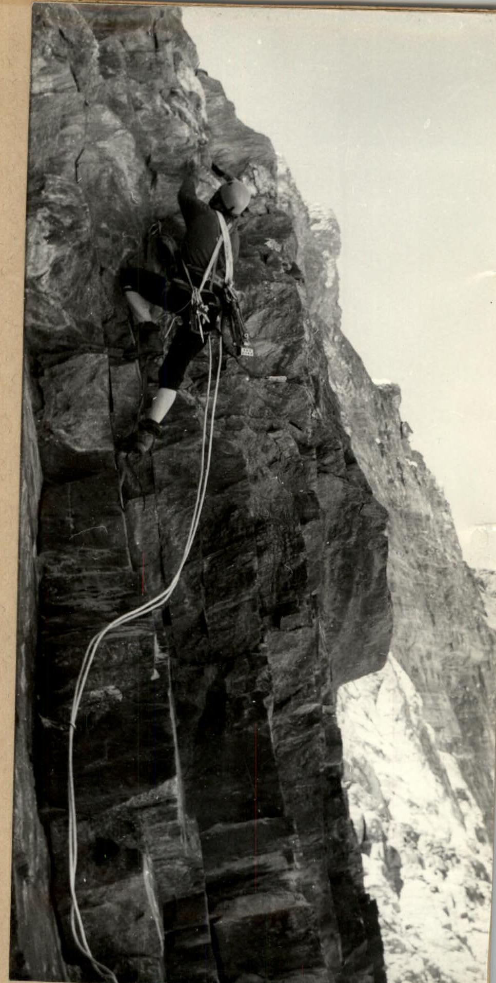
Ascent on the R5–R6 section. The beginning of the quartz belt is higher. Bershov S. in the picture.