Ascent Passport
I. Category: technically challenging ascents 2. Region: Central Pamir, upper reaches of the Vanch River. 3. Route: first ascent to Peak 5137 m (Shaugada) via the northeast wall. 4. Characteristics of the ascent: height difference 1100 m, average steepness: +50°, length of complex sections (5 and 6 difficulty category) – 335 m. 5. Pitons driven: rock — 40, ice — 22 (excluding descent) 6. Number of climbing hours: 18.5 (excluding descent) 7. Number and characteristics of bivouacs: one sitting bivouac on the wall on an artificial platform 8. Team name: team of the Leningrad City Council of the Spartacus Sports Society 9. Team composition:
Leader: GREKHOV Igor Vsevolodovich — 1st sports category
Members:
- Isaenko Gennadiy, 1st sports category
- Vostrova Irina Aleksandrovna — Candidate Master of Sports (unconfirmed)
- Chernov Vladimir, 1st sports category
- Baibora Viktor Savel'evich — 2nd sports category
- Gasilov Evgeniy Fedorovich — 2nd sports category
Team coach: KOLCHIN Aleksandr Aleksandrovich, Master of Sports of the USSR
Date of departure and return: August 18–22, 1975
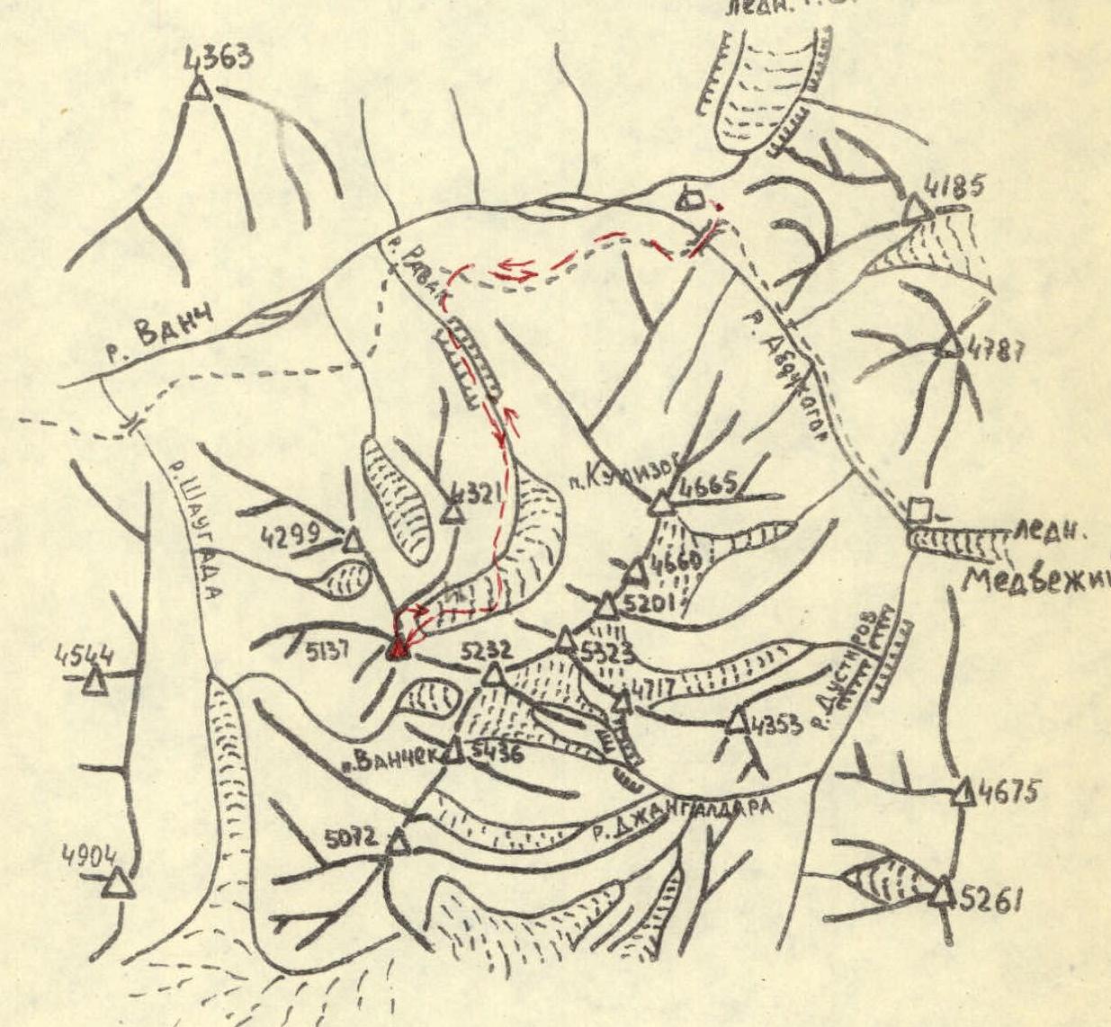
Map-scheme of the Ravak horseshoe area.
Geographical Overview of the Ascent Area
The area of the upper reaches of the Vanch River in the Pamir is characterized by numerous lower peaks in the spurs of the Darvaz Range and the Academy of Sciences Range, in addition to high peaks such as Peak Garmo and Peak Kom Akademii. The Vanch River valley is located very low. The Koy-Zog tract at the tongue of the Geographical Society Glacier, where the "Vysochnik" camp is located, has an elevation of 2600 m — close to the heights of Caucasian alpine camps. Therefore, routes to peaks around 5000 m have height differences from the camp to the summit of the same order as similar peaks in the Caucasus.
The nearest area to the camp with peaks above 5000 m is the cirque of the glacier feeding the Ravak River — the first left tributary of the Vanch River. The peaks surrounding this glacier have been named the "Ravak horseshoe" by climbers. The Ravak horseshoe is located at the northern end of a long spur of the Vanch Range. The highest peaks of this spur are Peak Vysokiy Yazgulem and Peak Vanchik (5436). The spur is a watershed between the Dusti-Roz and Shaugada rivers.
The horseshoe itself consists of six peaks, counting from the east:
- Kulizog 4665 m
- An unnamed peak on the map of approximately the same height, which the first ascenders propose to name Maly Ravak.
- Unconquered peaks 5201 m and 5323 m, and finally,
- Peaks 5232 m and 5137 m, which were the main objectives of the Spartacus ascent in 1975.
We propose to name these peaks Ravak and Shaugada, respectively. In the northeast spur of peak 5137 m is located peak 4321 m, which is an excellent panoramic point for the entire horseshoe.
Reconnaissance and Training Exits
For the second year, Spartacus climbers from Leningrad have been coming to the upper reaches of the Vanch River. The 1974 gathering was mainly dedicated to exploring the Komosomolets glacier area (lower right tributary of the Geographical Society Glacier), where a number of first ascents were made. However, reconnaissance of other areas was also conducted:
- The passage through the Ravak River canyon was explored.
- First ascents were made to Peak Kulizog and Peak Trinirovочный, located opposite the Ravak horseshoe across the Vanch River valley.
- From these peaks, the northern walls of the five-thousanders of the Ravak group were examined.
Photographs taken allowed for the planning of possible route options for 1975 in Leningrad. The most attractive seemed to be the route to the highest peak of the horseshoe via the center of the northern wall through a steep rock "bastion".
In 1975, on August 10-11, immediately upon arrival in Vanch, reconnaissance exits were made to finalize route choices. One group (Korkin, Kolchin, Razumov, Mukhina, Grekhov, Gasilov) ascended to the upper cirque of the Ravak glacier under the northern walls of Peak Ravak and Peak 5137 (Shaugada). As a result of this exit, routes were clarified:
- to Peak Ravak — for the first team;
- to Peak 5137 — for the second team.
Detailed route sketches were made with main landmarks and possible bivouac sites, along with preliminary descriptions and tactical ascent plans. Locations for assault camps in the upper cirque of the glacier and an observer camp on the lateral moraine were identified. Members of the second team made training ascents:
- first ascent to Peak Kulizog via the south ridge;
- first ascent to Peak Maly Ravak.
The first team already had a training ascent of 5B category difficulty on the Caucasus (traverse of Shkhelda).
The second reconnaissance group, consisting of Silin, Stepanov, and Davydov, traveled along the valleys of the Abdukagor, Dusti-Roz, and Jangal-dara rivers to the southern slopes of the Ravak horseshoe peaks. They identified paths for descent from Peak Ravak along the eastern ridge to the southern glacier and a way to bypass the canyons of the Jangal-dara River. This was very important since descent from the peak into the Ravak cirque is impossible due to hanging glaciers and rock laws.
The descent from Peak 5137 m (Shaugada) was planned along the north ridge and further into the upper cirque of the Ravak glacier to the assault camp.
From August 15 to 18, members of the second team, Baibora and Gasilov, observed the ascent of the first team to Peak Ravak and studied the rockfall regime from Peak 5137 m (Shaugada). They assessed the rockfall hazard on key sections of the route depending on the time of day.
Tactical Ascent Plan
The northeast wall of Peak 5137 m (Shaugada) has several very steep rock counterforts in its left part, descending from the summit practically to the beginning of the wall (elevation 4000 m). The right part of the wall is icy up to 4700 m with large rock islands. Above are steep rock counterforts (250–300 m), ending at a steep ice wall (60 m), leading to the pre-summit ridge. The route was planned along the right part of the wall. Reconnaissance showed that the upper steep part of the wall is composed of unstable rocks, and the first half of the day, when this part is sunlit, the wall experiences very strong rockfall. In the upper part, steep ice couloirs along the counterforts act as natural rockfall collectors, but in the lower part of the wall, rocks, having gained significant speed, sweep across practically the entire wall. However, the arrangement of rock islands allows them to be used as natural protection against rockfall.
The tactical ascent plan was built as follows:
- The route in the lower part should pass over ice to the right of the first and second rock islands, very close to them.
- The third rock island can be traversed over rocks.
- The nearest possible bivouac site is a platform at the foot of the wall leading to the counterfort from the top of the third island.
- Descent was planned along the north ridge to the first large "gendarme", under which a bivouac was to be made. Further descent along the ridge to an ice-snow couloir and down it to bivouacs in the upper cirque of the Ravak glacier.
- The team was to be supported by observers on the Ravak bivouacs with communication via "Vitalka" radios, and observers were to communicate with the camp via "Nedra" radios.
- Two reserve days were allocated for bad weather and unforeseen delays.
This tactical plan was largely followed, although the first bivouac was set up substantially higher than planned — at the foot of the pre-summit ice wall. Additionally, the north ridge, planned as the descent route, turned out to be significantly more difficult than expected (about 4B category difficulty).
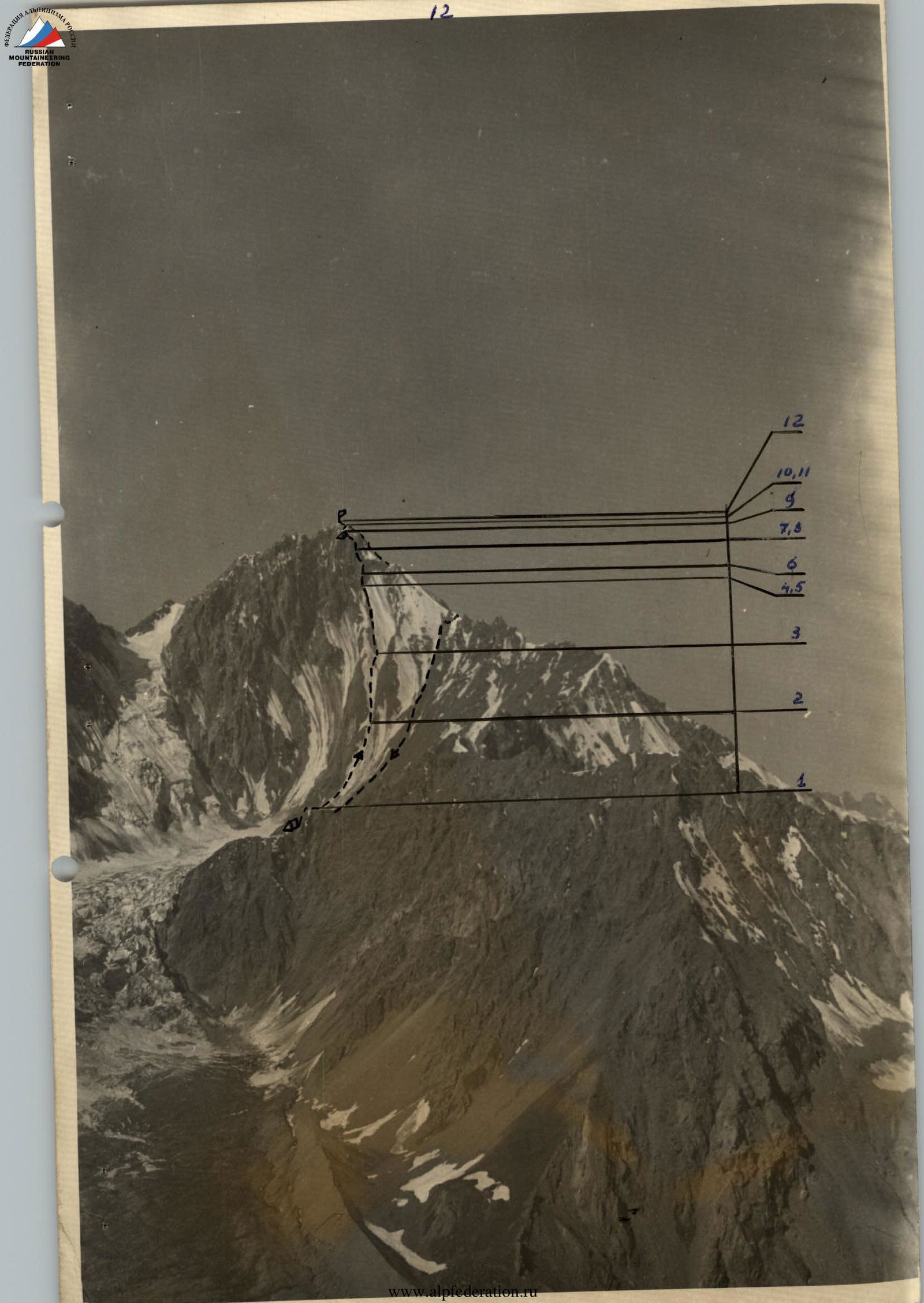
Description of the Route Ascent
The team, consisting of 4 climbers and 2 observers, left the Vysotnik alpine camp on August 18, 1975, at 7:00. Two team members were already in the upper reaches of the Ravak glacier, observing the ascent of the first team to Peak Ravak and reconnoitering the wall of Peak 5137 m.
- At 13:00, having passed the canyon, they reached the lower Ravak bivouacs ("Bear bivouacs"), where they left the observers (Davydov and Golenevskiy).
- At 16:00, having traversed the icefall on the right (orographic) side, they reached the upper Ravak bivouacs.
On August 19, 1975, at 4:00, the team of 6 people departed on the route. With headlamps in teams, they crossed the glacier and at 5:00 crossed the bergschrund (section R1), driving an ice piton.
- The first rock island was bypassed on the right along relatively gentle (25–30°) ice with embedded stones (section R2). Movement was simultaneous; reaching the top of the island took about 2 hours.
- The second rock island was also bypassed on the right along ice, the steepness of which increased and reached 50° at the upper end of the island (section R3). The last 4 ropes were traversed with piton protection (13 pitons). The steepest final part of the ice was ascended by Grekhov first, driving 4 pitons on the rope. They reached the top of the island at 9:30.
Around 8:30, strong rockfall began down the couloir to the left of the island; occasionally, stones flew over the island, crossing the route.
- The third rock island (section R4) is a ridge with rocks of medium difficulty. Movement was mostly alternating, with protection through ledges and pitons (7–8 ropes, 5 pitons). They reached the top of the island at 12:00.
- A нависающую wall 3.5–4 m before the exit to the platform before the wall leading to the counterfort was ascended by Baybora, who drove 4 pitons and hung a ladder (section R5). The group assembled on the platform at 12:30.
Until this time, there was heavy fog, visibility was no more than 50–80 m, but they oriented themselves fairly confidently on the route due to thorough reconnaissance. Then visibility improved. The platform was safe, but it was too early to bivouac; the decision was made to continue upwards.
- The wall before the counterfort (40 m) is traversed from right to left upwards (section R6). Climbing is very difficult, rocks are steep and местами мокрые. The wall was ascended by Isaenko in galoshes, without a backpack, driving 10 pitons and hanging a ladder. The group was in the left part of the platform, protected from rocks by the нависающей part of the wall.
- After a short rest, they went up along the fixed rope, climbing in galoshes with backpacks. Isaenko's backpack was pulled up.
- After the wall — a traverse (section R7) from left to right onto a wall (5 m, 2 pitons), leading to the edge of the counterfort through an inclined slab (2 pitons).
- Further — 1 rope along complex rocks (3 pitons) to a ledge.
- Then — along inclined slabs (1 rope, 4 pitons) — exit to a sharp ridge.
- Further along the ridge (1 rope) to its end, resting against a wall.
Grekhov led the entire section. Teams worked independently, using the pitons of the first team. Cramp ons were put on under the wall. The wall (section R8, 6 m, steep wet rocks) and further along complex rocks of the counterfort were ascended by Gasilov, who drove 5 pitons and hung перила. The next rope to the end of the counterfort was ascended by Isaenko (3 pitons, complex rocks) and also hung перила (section R9). Under the ice wall leading to the pre-summit ridge, the group assembled at 20:00. On the entire section of the route from the rock wall before the counterfort to the ice wall, there were no bivouac sites, and only at the boundary of the counterfort with the ice wall was an inclined scree ledge found, which after an hour's work was turned into a platform for a sitting bivouac.
On August 20, the weather worsened in the morning, and sleet began. Quickly gathering, they departed at 8:00 towards the ice wall. The wall (section R10) is ascended from left to right upwards between two large cornices, exiting onto the ridge at the right cornice. The steepness of the wall is more than 50°, in places up to 60°; length — 2 ropes. The first rope was ascended by Chernov with step cutting (4 pitons), the second — by Isaenko also with step cutting (4 pitons) and exited onto the ridge at 10:00. The others followed in sports style. On the ridge, there were excellent bivouac sites. Further along the ridge (section R11) along rocks of medium complexity (variable protection, 1 piton) — exit under a rock wall leading to the summit. The wall (section R12, 20 m, 4 pitons) was ascended by Grekhov and перила hung. They reached the summit at 11:30. Visibility was about 100 m, so they couldn't take a panorama. They began their descent at 12:30.
Recommendations for Future Ascents on this Route
- The lower part of the route (up to the exit to the third rock island) is very prone to rockfall, so it should be traversed as early as possible and as quickly as possible. The bergschrund must be crossed no later than 5:00 AM!
- From the wall before the counterfort to the pre-summit ridge, there are no bivouac sites, so it's highly desirable to reach the ridge on the first day. For this, the group should consist of no more than 4 people of sufficiently high qualification. The ascent can be accelerated by exiting onto the rocks in the upper part of the second rock island and bypassing the steep ice at the start of the third island.
- In cold weather, rockfall danger will significantly decrease, but in this case, the rocks of the wall at the start of the counterfort will likely be covered with a crust of rime, and in several places, it may be necessary to climb with ice axes.
- The descent route along the northwest ridge is a logical and not too rockfall-prone rock-ice route of 4B category difficulty. We recommend it for ascent.
Assessment of Participants' Actions
All team members participated in preparing the ascent, reconnaissance, and developing the tactical plan. Previous joint ascents served as good training and ensured cohesion. During the ascent, their good physical preparation and endurance during prolonged work on complex combined terrain were confirmed. Everyone is proficient in technical techniques for moving on snow, ice, and rocks, as well as technical belaying. Practically all worked as leaders on individual sections of the route. There were no incidents or delays due to participants. The ascent proceeded clearly and in an organized manner.
Team captain: Grekhov I.V. Coach: Kolchin A.A.
Route Assessment
The route is similar in character and height difference to routes on the Bezengi peaks via the northern walls. In particular, it is very similar to the route on Ullu-Auz via the wall — a significant length ice wall in the lower part, leading to steep complex rocks. However, the length of the rock section is greater, and it is significantly more complex. The route is also complicated by the high rockfall danger in its lower part, which places high demands on the organization of the ascent. Overall, the team assesses the route's difficulty as not less than 5A category.
Team captain: Grekhov I.V. Coach: Kolchin A.A.
TABLE OF MAIN CHARACTERISTICS OF THE ASCENT TO PEAK SHAUGADA (5137 m)
- Route: NE wall
- Difficulty category: 5A category
| Date | Sections traversed | Average steepness of the section | Length of the section | Characteristics of the section and ascent conditions | Difficulty category | Method of overcoming | Weather conditions | Time of bivouac, departure, climbing hours | Rock pitons driven | Ice pitons | Bivouac conditions |
|---|---|---|---|---|---|---|---|---|---|---|---|
| 19.08 | R0–R1. Bergschrund crossing | 45–50° | 8 m | Ice wall | 3 | Pitched protection, перила | Fog | 20 min | 1 | - | - |
| R1–R2. Bypass of the first rock island | 25–30° | 400 m | Ice with individual embedded stones | 3 | Crampons, protection via ledges | Fog | 2 hours | - | - | - | |
| R2–R3. Bypass of the second rock island | 35–40°, upper part up to 50° | 300 m | Ice | 4–5 | Crampons, front points, piton protection, перила | Fog | 2 hours 30 min | - | 13 | - | |
| R3–R4. Ascent of the third rock island | 50° | 300 m | Strongly destroyed blocky rocks, monolithic | 4 | Alternating movement with protection via ledges, pitons | Fog | 2 hours 30 min | 5 | - | - | |
| R4–R5. нависающая wall | 90–95° | 3.5–4 m | Solid rocks | 6 | Climbing with artificial support | Fog | 30 min | 1 | - | - | |
| R5–R6. Wall before the counterfort | 80° | 40 m | Rock wall, нависающая in the left part. Solid rocks with few holds, местами мокрые | 6 | Complex climbing with artificial support, in galoshes without a backpack, перила | Good weather | 2 hours | 10 | - | - | |
| R6–R7. Counterfort | 65–70°, местами 80–85° | 120 m | Rock counterfort, местами interrupted by walls 4–5 m high, inclined slabs | 5 | Climbing with piton protection, in galoshes | Good weather | 1 hour 30 min | 11 | - | - | |
| R7–R8. Wall | 80° | 6 m | Rock wall | 5 | Climbing with piton protection | Good weather | 30 min | 3 | - | - | |
| R8–R9. Counterfort | 65–70° | 80 m | Rock counterfort with iced rocks in the upper part | 5 | Climbing with piton protection, перила | Good weather | 1 hour | 5 | - | Sitting bivouac | |
| R9–R10. Wall before the ridge | 55–60° | 60 m | Ice wall | 6 | Step cutting, piton protection | Fog, sleet | 2 hours | - | 8 | - | |
| R10–R11. Ridge | 15–20° | 40 m | Rock ridge | 3 | Alternating movement with protection via ledges and pitons | Fog | 30 min | 1 | - | - | |
| R11–R12. Pre-summit wall | 75–80° | 20 m | Rock wall, dissected by a cleft | 5 | Complex climbing, piton protection, перила | Fog | 1 hour | 4 | - | - | |
| Total pitons | 40 | 22 |
