
- Climbing class: technical
- Climbing area: Vanch Ridge
- Peak, elevation, route: Cherepovets, 5200 m, via north counterfort
- Proposed difficulty category: 4B
- Route characteristics: elevation gain: 1200 m average steepness: 49° length of sections with I difficulty: 300 m length of sections with II difficulty: 280 m length of sections with III difficulty: 660 m length of sections with IV difficulty: 630 m length of sections with V difficulty: 130 m
- Pitons hammered: for belaying: rock: 103 ice: 4 bolt: — for aid climbing: rock: 13 ice: — bolt: —
- Number of climbing hours: 21
- Number of nights and their characteristics: 2 (lying down, on artificial platforms)
- Participants' full name, qualification:
- Bregman Eduard Emmanuilovich: Candidate for Master of Sports, captain
- Titkin Evgeny Georgievich: Candidate for Master of Sports, participant
- Kiselev Georgy Konstantinovich: 1st sports category, participant
- Sirotin Vladimir Ilyich: 1st sports category, participant
- Team coach: Bregman E.E.
- Date of departure and return:
departure July 27, 1979
return July 30, 1979
Map diagram
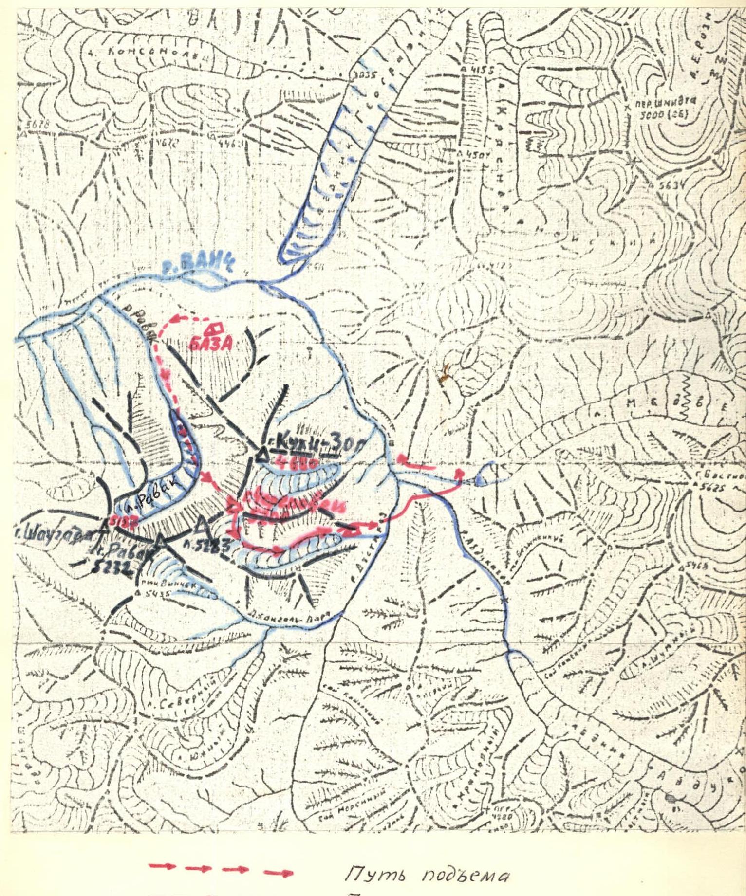
Approach to the route
The approach starts at the bridge over the Ravak River, 8 km above the village of Poymazar.
The Ravak gorge, an orographic left tributary of the Vanch gorge, begins with a narrow, shaded canyon oriented north. It's even choked with avalanche debris in August, and the ascent through it is straightforward and fast.
After 2 hours of ascent, the gorge widens, and after another hour of walking over moraines and snowfields, you reach the Ravak Glacier. Here, the gorge smoothly turns to the right, towards the icefall below the peaks of Ravak and Shaugada. Peak Cherepovets towers directly ahead. Another hour of movement, on the last moraines, is suitable for setting up the initial bivouac.
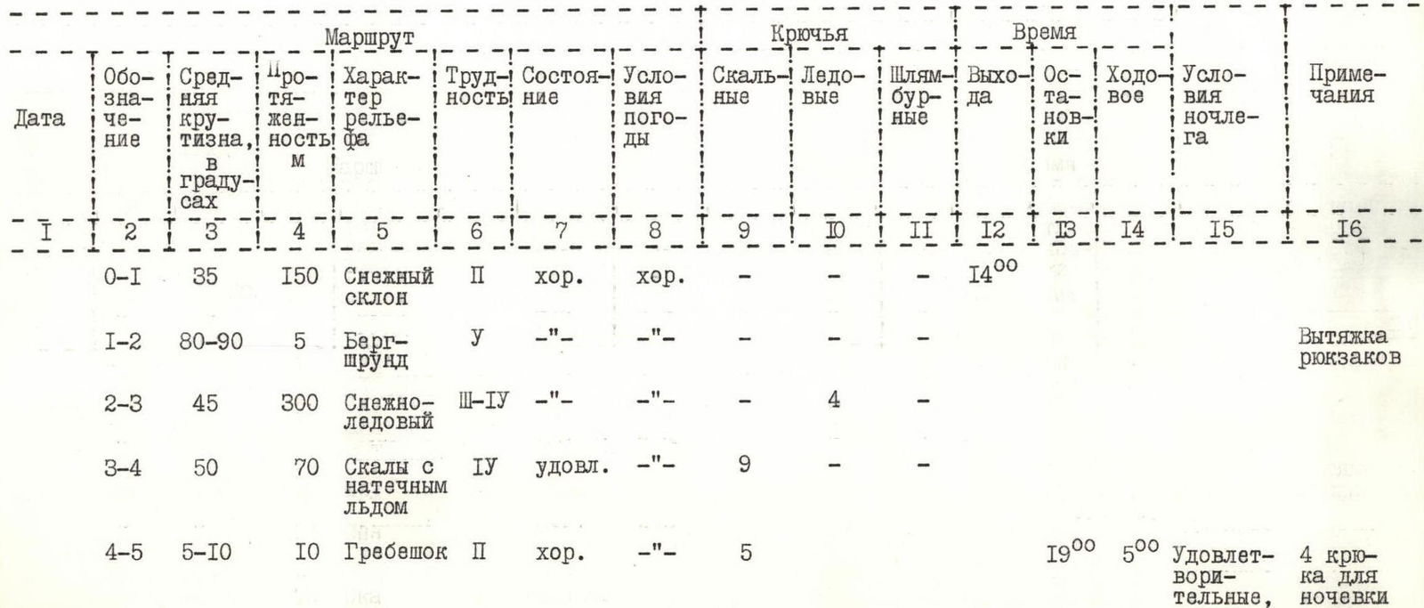
Table of main route characteristics
Elevation gain 1200 m. Average steepness 49° (excluding the upper ridge)


Explanations for the table of main characteristics
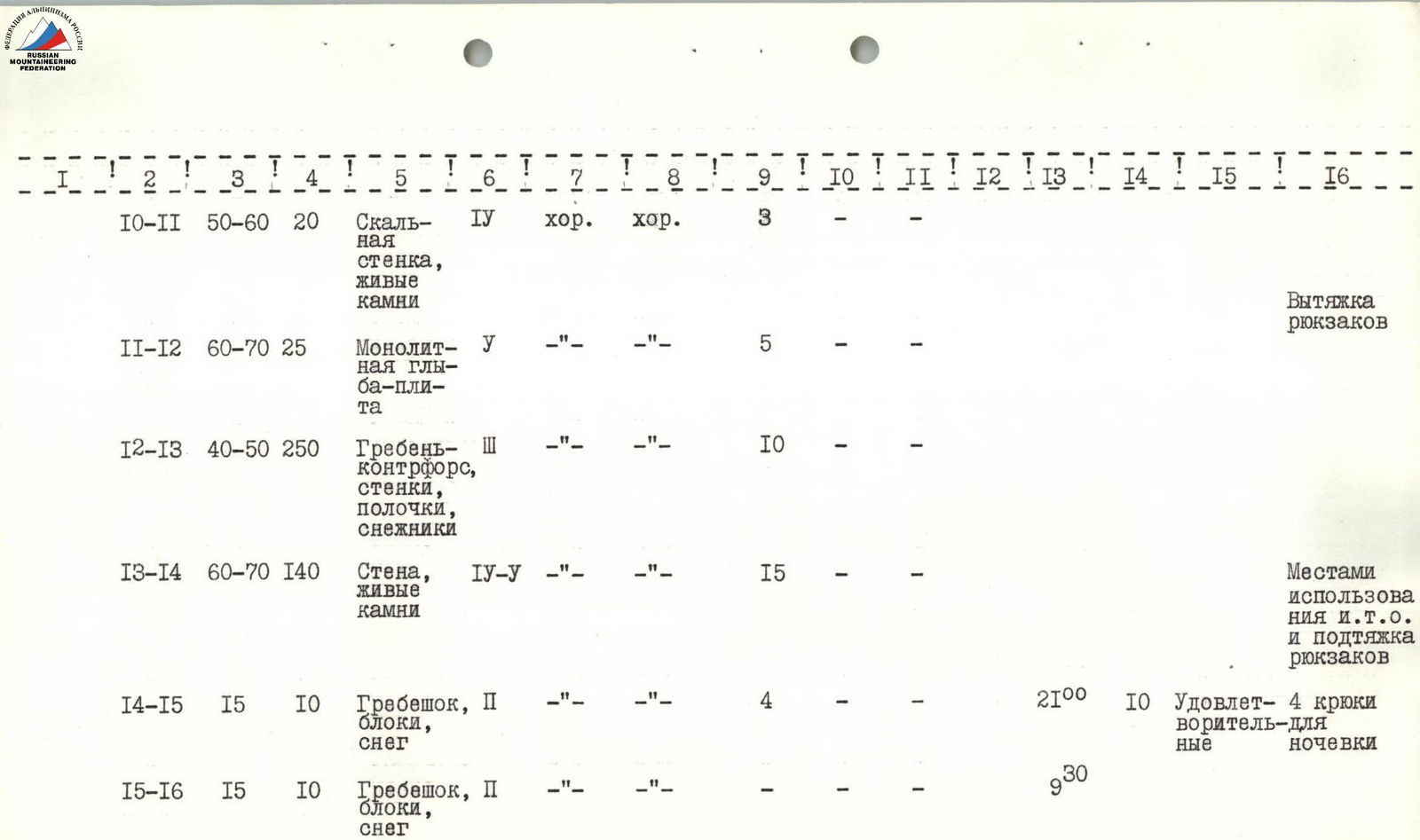
Section R0–R1. Snow slope.
- Simultaneous movement
- Change of lead
Section R1–R2. Snow-ice wall of the bergschrund.
- Passage with the help of a boost and driven ice axes
- In the upper part - cutting a passage
- Pulling up backpacks
Section R2–R3. Snow-ice slope. Movement is simultaneous at the bottom, then alternate. Belaying via ice axes and ice screws (upper 2 ropes).
Section R3–R4. Rocks with flow ice. Hazardous transition from ice to rocks. Very careful movement. Crevices are filled with ice, everything is smooth. Independent rope team movement.
Section R4–R5. Ridge. Narrow rocky outcrop with snowy cornices. Selection of a place for an overnight stay, construction of a platform.
Section R5–R6. Section above the rocks with flow ice (R3–R4). Traverse with a gain in height. Rappel lines.
Section R6–R7. Inner corner, bounded on the left by a smooth wall, and on the right - by ice-filled rocks (above a snowy cornice). Orientation is northeast, a cold corner.
Movement:
- 2nd
- 3rd
- 4th with jammers, without backpacks.
Section R7–R8. Sloping left and down, with a throw-out, slab, bounded on the right by a wall. Ends with a narrowness with a sloping crevice, where they moved in a wedged position, using a ladder and jammers.
Section R8–R9. Uncomplicated rocks, leading to a rocky outcrop above sections R5–R8. Pulling up backpacks here.
Section R9–R10. Uncomplicated ridge - transition between walls.
Section R10–R11. Rock wall, exposed. Psychologically difficult, as both to the right and left of the ridge (section R9–R10) the wall drops steeply down. Movement without backpacks.
Section R11–R12. Rock wall (section R10–R11) turns here into a monolithic slab-block, split off from the main massif. The first one passed it with free climbing, using a pendulum swing to a convenient section of the monolith's edge in the middle part.
Pulling up backpacks on section R10–R12.
Section R12–R13. Ridge, similar to section R9–R10, transition to the next wall.
Section R13–R14. Section represents a wide wall, simpler than section R11–R12, but in places there are wall sections requiring the use of a ladder and jammers. In two places, the first one passed 4-5 m without a backpack. And the subsequent ones pulled up their backpacks using a hanging belay rope (backpacks were not removed from their shoulders). Movement is partially by independent rope teams.
Section R14–R15. Another ridge, similar to the previous ones. Setting up a platform for an overnight stay.
Section R15–R16. Same as R14–R15.
Section R16–R17. Sloping, smooth slabs, with traces of avalanches and stones. They go up to the sub-summit and to the ridge, from where stones and icicles constantly fall in the second half of the day (western orientation). Movement by independent rope teams. Traversing slabs.
Section R17–R18. At first, faster movement through a couloir, and then along the rocks on its right (along the path) part. The lower part represents an overhanging block, and then there's something like a steep ridge-wall. Stones periodically fall along the couloir. Use of rappel lines and jammers.
Section R18–R19. Same as R17–R18, but more gently sloping. Movement by independent rope teams.
Section R19–R20. The couloir, expanding, led to a rocky cirque, leading to the sub-summit ridge. Alternation of:
- slabs,
- small walls,
- couloirs,
- small snowfields in niches.
Wide use of outcrops for belaying.
Section R20–R21. Steeper rocky section, representing an ascent to the ridge. Cutting through a snowy cornice with icicles.
Section R21–R22. Snowy-scree ridge, leading to the summit. In places, with northern exposure, snowy cornices.
The descent was made into the Dusti-Roz gorge, to the southeast. From 18:00 to 21:00, descending mainly through snowy couloirs and avalanche debris, the group reached a green meadow by a stream flowing from the southern cirque of peak Cherepovets and peak 5223 into the Dusti-Roz River.
Radio communication
During the ascent, in the Ravak cirque, groups were making ascents:
- Ural and Siberian Military Districts on peak Ravak,
- Siberian District group - on peak Shaugada.
Communication was maintained between all groups and with the base radio station at the bridge over the Ravak River, which has a direct line of sight with most of the route on peak Cherepovets.
Additional route characteristics. Recommendations.
Overall, the route represents a counterfort-wall with a northern orientation, bounded on the right by a couloir from the saddle between peaks Cherepovets and 5223, and on the left - by a smooth wall of the sub-summit (from N-E) of Cherepovets, where a very complex 5B category route with sections of 6th category can be laid out.
Due to the shaded and cold nature of the route, as well as the fact that it's framed by ridges with snow from above, movement is complicated even in good weather by flow ice.
It's recommended to start the route early in the morning. On steep sections, where stones fall, stop movement from 15:00 to 16:00, when the sun starts illuminating the western ridges.
Comparative analysis of the route
Group participants Titkin, Kiselev, Sirotin, before ascending peak Cherepovets, made a 5B category ascent on peak Bastion, Van ch ridge, via Piskulova route. In their unanimous opinion, the route on peak Cherepovets is more complex.
Group participants in 1975-1978 made 5B category ascents:
- Chatyn
- Ullu-Tau
- Dzhaïlyk
- Bodkhona (Zhiteneva)
- Rudaki
- Saryshakh
- Zamok (first ascent, Fann Mountains)
Some of these routes are equal to or weaker than the one passed - for example, Rudaki, Saryshakh, Dzhaïlyk, Zamok.
The group believes that the route corresponds to the 5B category.
Team captain
(Bregman)
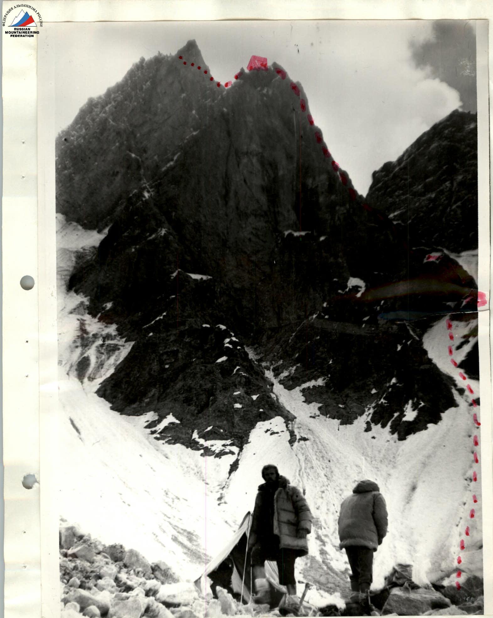
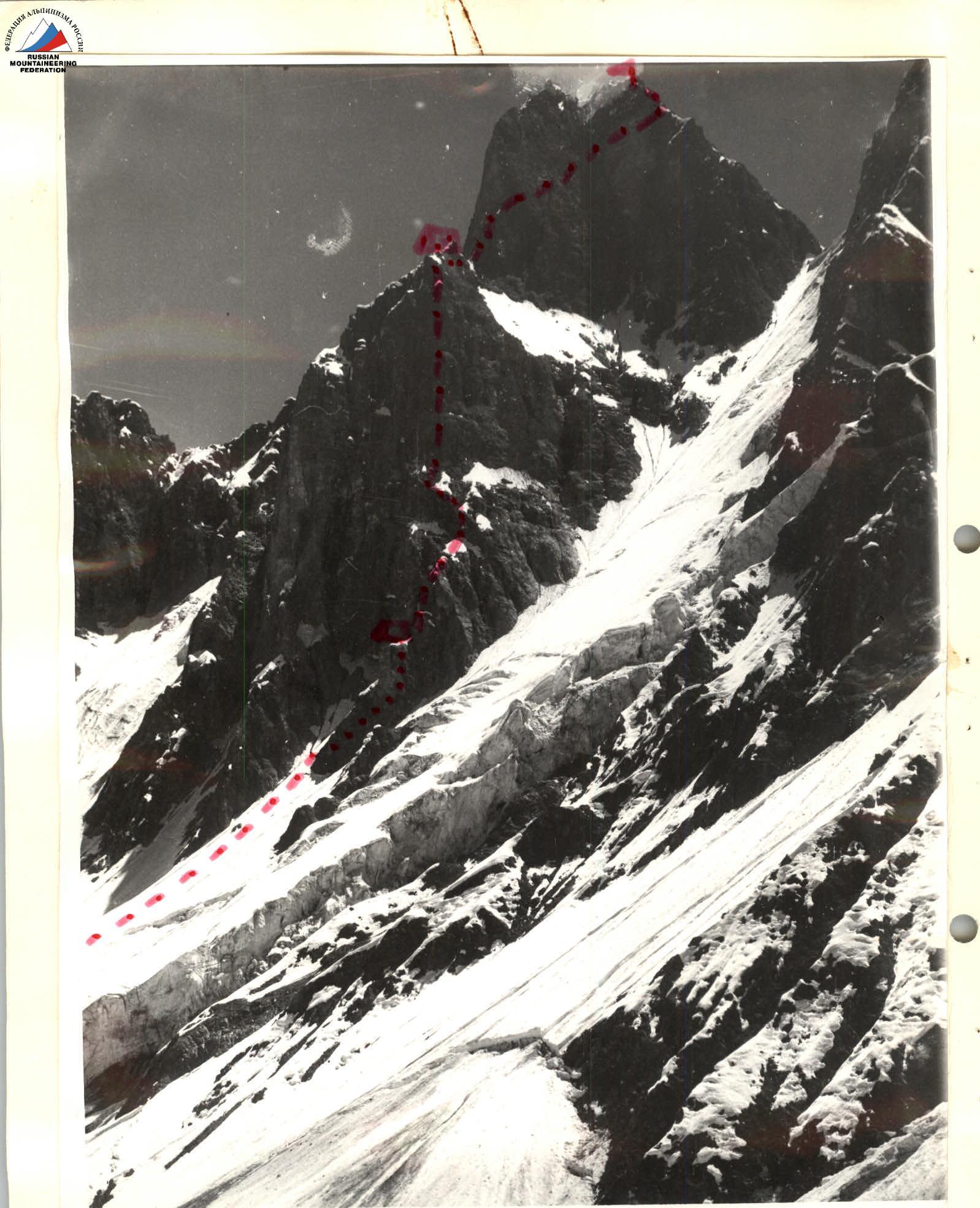
Bivouac on Ravak Glacier. The предполагаемый путь (planned path) of the group to the second overnight stay is marked with a dotted line.
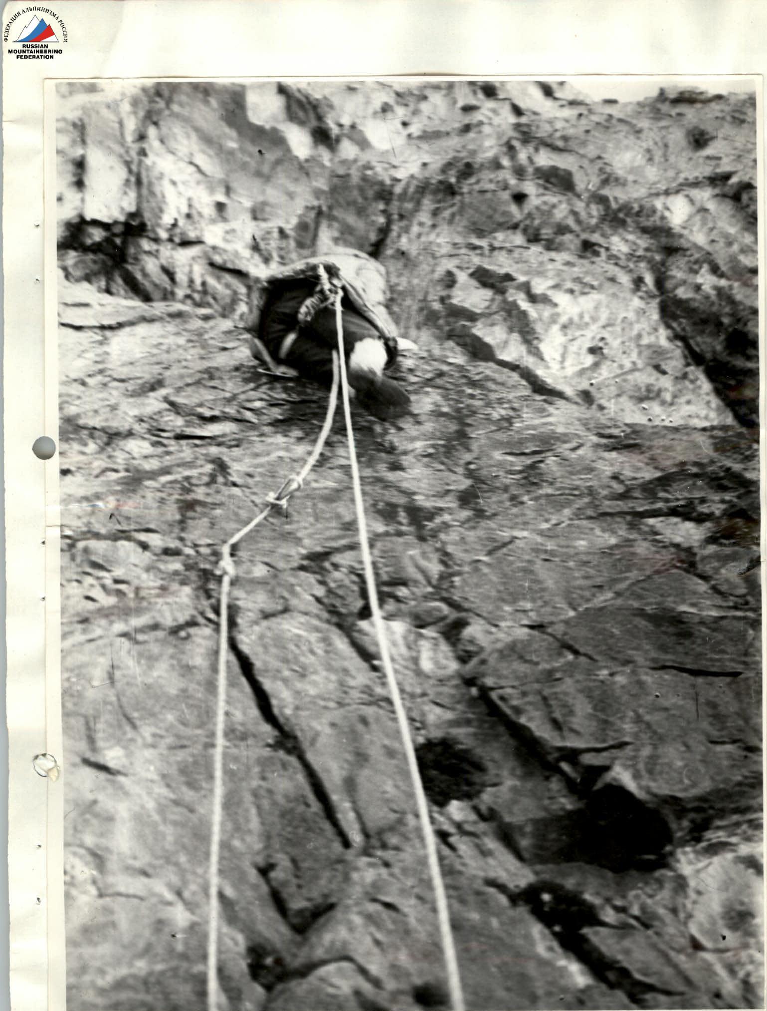
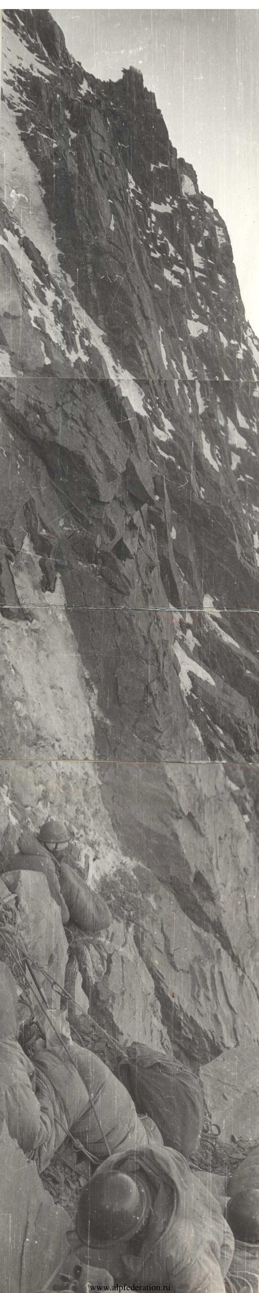
On the wall. E. Titkin is leading.

Section of the wall in the central part of the route.
Comments
Sign in to leave a comment