
I. Ascent Passport
- Category: technically challenging ascents.
- Area: Central Pamir, upper reaches of the Vanch River.
- Route: first ascent to Peak 5232 m (Ravak) via the center of the north face.
- Characteristics of the ascent:
- height difference — 1200 m;
- average steepness — 60°;
- length of complex sections (5 and 6 cat. diff.) — 875 m;
- Pitons driven:
- rock — 126;
- ice — 29;
- bolt — 1.
- Total climbing hours: 44 hours.
- Number of bivouacs and their characteristics: total of 4 bivouacs on the wall. 3 bivouacs on artificial platforms on snow "mushrooms" under rock walls, 1 bivouac on a platform carved on a sharp ice ridge.
- Team name: team of the Leningrad City Council DSO "Spartak".
- Team composition:
leader: Korkin Igor Vasilievich, Master of Sports of the USSR;
participants:
- Silin Boris Mikhailovich, 1st sports category;
- Razumov Yuri Mikhailovich, 1st sports category;
- Stepanov Vitaly Nikitich, 1st sports category;
- Mukhina Inessa Vitalievna, 1st sports category.
- Team coach: Kolchin Alexander Alexandrovich, Master of Sports of the USSR, International Class.
- Dates of departure and return: August 13–19, 1975.
Area Map-Scheme
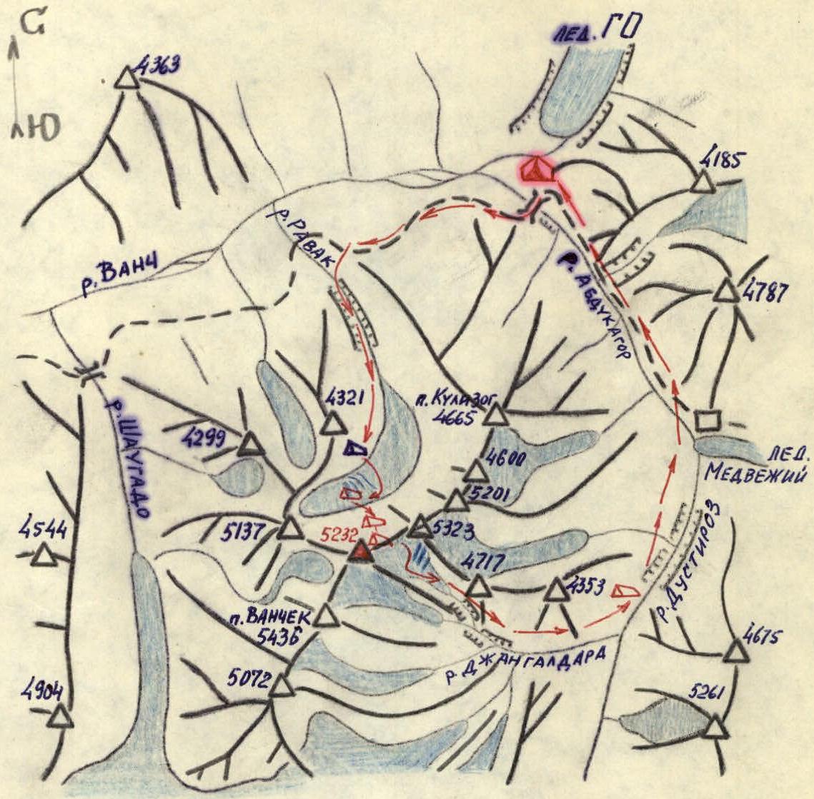 — "Vysotnik" base camp
Δ — Ravak bivouacs
Δ — storm group bivouacs
λ — ascent route
— "Vysotnik" base camp
Δ — Ravak bivouacs
Δ — storm group bivouacs
λ — ascent route
Geographical Overview of the Ascent Area
The upper reaches of the Vanch River in the Pamir region are characterized by numerous lower peaks in the spurs of the Darvaz Range and the Academy of Sciences Range, alongside higher peaks. The Vanch River valley is located quite low. The Koy-Zog tract, near the tongue of the Geographical Society Glacier, where the "Vysotnik" camp is situated, has an elevation of 2600 m, similar to the heights of Caucasian alpine camps. Therefore, routes to peaks around 5000 m have height differences from the camp to the summit similar to those of analogous Caucasian peaks. A nearby area with peaks over 5000 m is the cirque of the glacier feeding the Ravak stream, the first left tributary of the Vanch River. The peaks surrounding this glacier are known as the "Ravak horseshoe". The Ravak horseshoe is located at the northern end of a long spur of the Vanch Range. The highest peaks in this spur are Peak Vysoky Yazgulem (5584 m) and Peak Vanchik (5436 m). The spur is the watershed between the Dustiroz and Shaugaido rivers. The horseshoe itself consists of six peaks, counting from the east:
-
- Kulizog 4665 m;
-
- an unnamed peak of similar height, proposed to be named Maly Ravak;
- 3,4) unclimbed peaks 5201 m and 5323 m, and finally,
- 5,6) peaks 5232 m and 5137 m, the main objectives of the 1975 Spartak ascent. These peaks are proposed to be named Peak Ravak and Peak Shaugadi. In the northeastern spur of Peak 5137 m lies Peak 4321 m, a panoramic point for the entire horseshoe. The heights of the Ravak horseshoe peaks as marked on the map may contain errors. The nodal peak marked as 5232 (Peak Ravak) is actually the highest point of the horseshoe, about 100 m higher than Peak 5323 m; relative to Peak Vanchik (5436 m), it is indeed about 200 m lower. The five-thousanders of the Ravak horseshoe drop northwards with steep, rocky, and glaciated walls. These walls resemble those of the Northern Bezengi peaks (Kostan-Tau, Dykh-Tau, etc.) in terms of route characteristics and height difference. The walls are partially composed of granite and sedimentary rocks, some of which are quite fragile, leading to frequent rockfall. Ice couloirs between peaks become impassable with the first sun rays. The southern side of the Ravak horseshoe peaks has long, relatively gentle, and not very dissected ridges. Between these ridges lie small, high-altitude glaciers. Streams from these glaciers have very steep gradients and flow through deep canyons. Alpine routes from the south are likely simpler and suitable as descent paths if the canyons can be bypassed.
Reconnaissance and Training Exits
For the second consecutive year, Leningrad "Spartak" climbers visited the upper reaches of the Vanch River. The 1974 gathering focused mainly on exploring the Komsomolets Glacier area, where several first ascents were made. However, other areas were also scouted, including the passage through the Ravak River canyon. First ascents were made to Peak Kulizog and Peak Trenyrovochny, located opposite the Ravak horseshoe across the Vanch River valley. From these peaks, the formidable north faces of the Ravak group five-thousanders were examined. Photographs taken allowed for the planning of possible routes for 1975 in Leningrad. The most attractive route seemed to be to the highest peak of the horseshoe via the center of the north face through a sheer rock "bastion".
In 1975, on August 10–11, immediately upon arrival in Vanch, reconnaissance exits were conducted to finalize route choices. One group (Korkin, Kolchin, Razumov, Mukhina, Grekhov, Gasilov) ascended to the upper cirque of the Ravak Glacier under the north faces of Peak Ravak and Peak 5137. This exit clarified the routes to Peak Ravak for the first team and to Peak 5137 for the second team. Detailed sketches of the routes were made, including key landmarks and potential bivouac sites, along with preliminary descriptions and tactical plans for the ascents. Sites for storm camps in the upper cirque and an observer camp on a lateral moraine were identified. Participants of the second team trained by making a first ascent of Peak Kulizog via the south ridge and a first ascent to Maly Ravak.
Tactical Plan for the First Ascent
The ice-rock wall of Peak Ravak has an average steepness of about 60° and a height difference of approximately 1200 m. The wall is heavily fractured. The wall can be divided into three equal parts vertically. The middle part is a nearly vertical rock bastion 400 m high, below which lies a 45° ice slope with a rock island in the middle, and above it, a steep (up to 60°) rock-ice slope. In the morning and evening, this slope is most exposed to the sun, causing rockfall, which collects in the steep ice gullies on either side of the bastion. Possible bivouac sites are envisioned on snow "mushrooms" on rock ledges on the wall and on a ridge above the bastion.
Based on these observations, a tactical plan was devised:
-
- The group should not exceed five people (one tent).
-
- Crossing the bergschrund should be done before 8:00 AM, and ascent up the ice slope to the rocks of the bastion should be completed by 10–11 AM due to increased rockfall danger.
-
- The first bivouac on a snow "mushroom" at the top of the 1st rock "triangle" in the lower part of the bastion.
-
- Bypassing the upper overhanging part of the bastion to the right along its edge and exiting onto the ridge above the middle part of the bastion.
-
- Bivouac on a snow "mushroom" on the ridge.
-
- Ascent up the rock-ice slope to the summit rock tower with overhanging snow cornices, then moving left onto the east ridge of the peak, where another bivouac is planned.
-
- Ascent along the east ridge to the summit.
-
- Descent along the east ridge and then right onto the "south" glacier.
-
- Returning to camp via the glacier and the left bank of the Jangaldara and Dustiroz rivers (the descent route was previously reconnoitered).
-
- Throughout the ascent, the group is to be supported by observers on Ravak bivouacs and in contact with the base via radios.
-
- Two reserve days are allocated for bad weather or unforeseen complications.
This tactical plan was largely followed, except for the passage of the bastion, which took two days due to extremely difficult rock.
Description of the Route Passage
The team left the "Vysotnik" base camp on August 13 at 7:00. The Ravak River canyon was easily passable that year due to snow plugs. After 5 hours of walking across debris covering the glacier and then along the right moraine, we reached the "Ravak bivouacs", a beautiful spot for a camp.
Here, we rested, examined our route in detail, memorized landmarks, and noted the timing and paths of rockfall. After checking radio communication with the base camp, we proceeded through the icefall to the upper glacier plateau under the walls of Peak 5232.
On August 14, we began our ascent at 5:30. Stepanov and Razumov went ahead to process the bergschrund crossing. We followed, dismantling our bivouac. The ice gully we crossed was already experiencing ice and rockfall. The ascent involved several sections, including crossing the bergschrund with the aid of a fixed rope, ascending a 45° ice slope, and navigating through rock sections with the aid of pitons and ladders.
We bivouacked on a snow "mushroom" on the first "triangle" of the bastion. The next day, we continued through the bastion, facing difficult rock sections and rockfall. We bivouacked again on another snow "mushroom" above the bastion.
On August 16, the weather improved, and we continued our ascent, tackling the upper part of the bastion and reaching the ridge above it. We bivouacked on a snow "mushroom" on this ridge.
On August 17, we resumed our ascent, traversing the ridge with complex ice and rock sections, eventually reaching the east ridge of the peak. We made our final bivouac on a platform carved into the ice ridge.
The next day, we ascended to the summit via the east ridge, facing a challenging ice wall just below the summit. After reaching the summit, we descended along the east ridge and then to the south glacier, finally returning to the base camp on August 19.
Route Assessment
The route is comparable in character and height difference to rock routes on the Bezengi five-thousanders via the north faces. It is more challenging than the Kosh-Tau wall via Simonik and the Sалынан-Баши north wall route that ranked 9th in the 1974 USSR championship. The route's complexity is similar to the Krumkol 6B category route, with comparable psychological tension but longer complex sections. Specific Pamir difficulties include very steep and dense ice, snow "mushrooms" on rock spires, and a thin, fragile limestone crust on granite rocks. Weather in the upper Vanch River area is generally more stable and better than in the Caucasus for peaks of similar height.
Team Captain: Korkin I.V.
Coach:
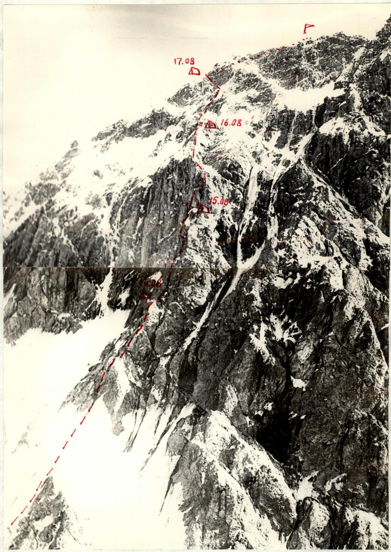
Profile photo of Peak 5232 m from Peak 5137 m
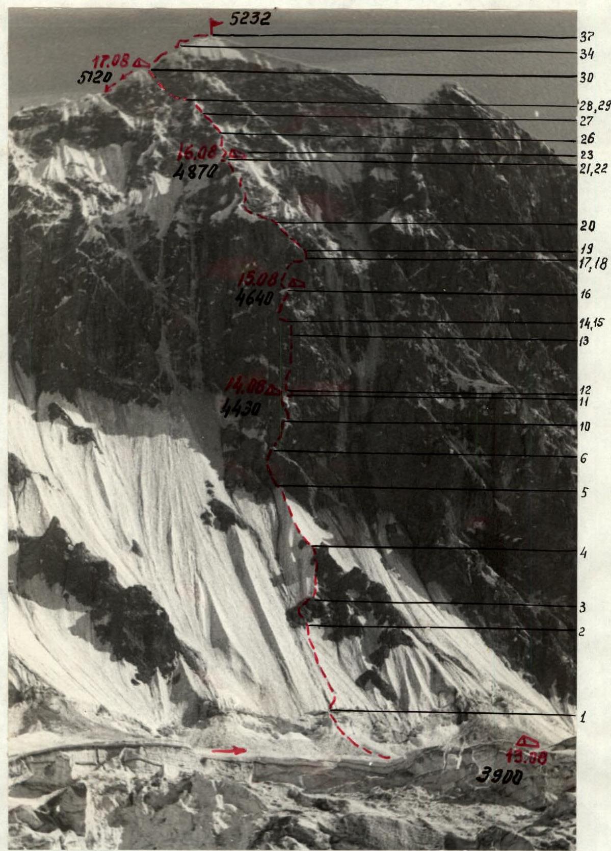
North face of Peak 5232 m (Peak Ravak). Bivouacs and sections of the first ascent route are indicated.
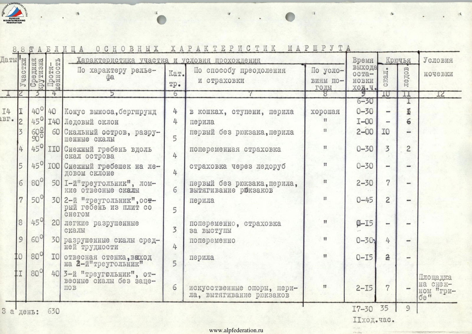
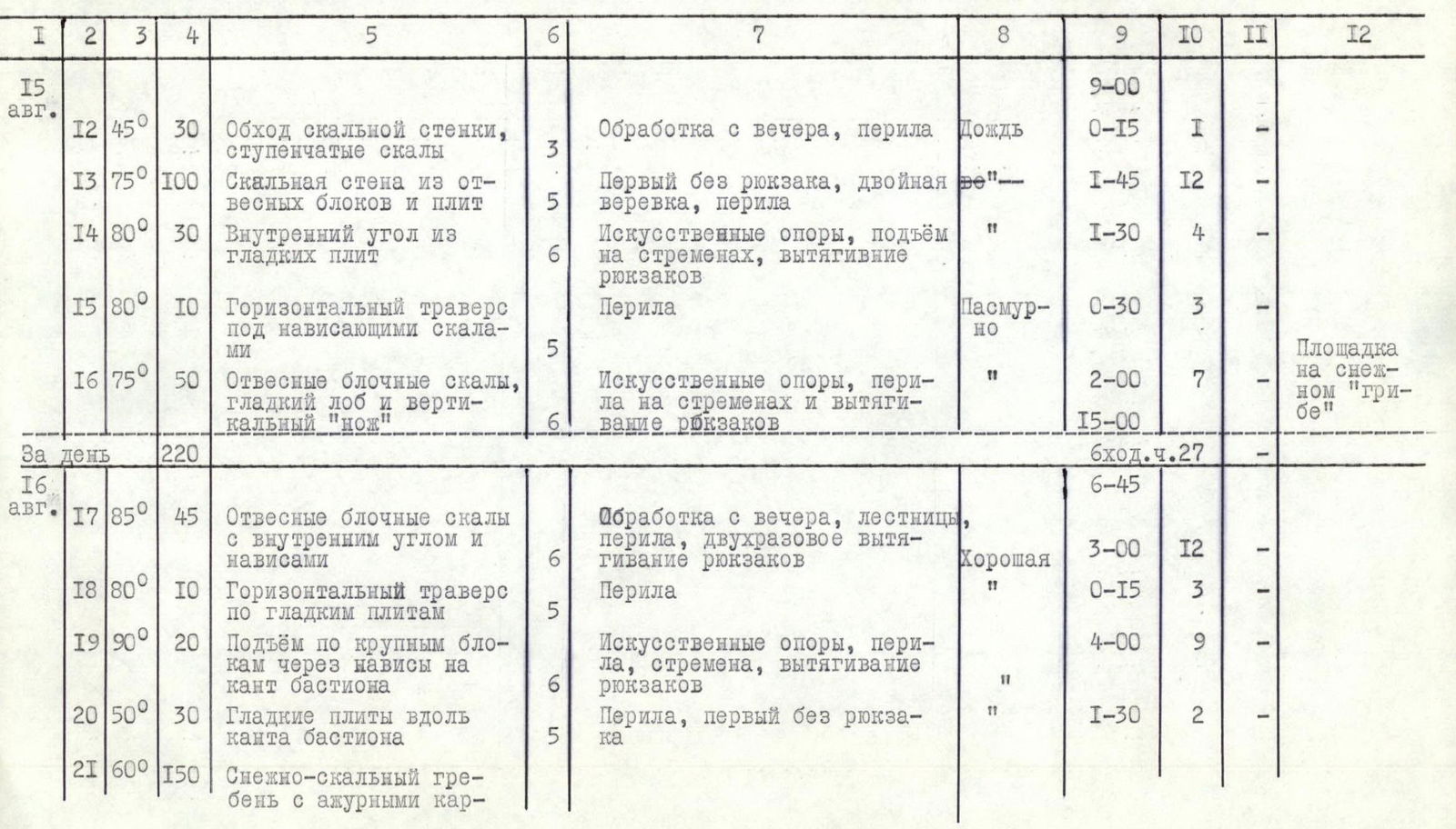
Table of Main Route Characteristics
| № | Section | Average Steepness | Length, m | Section Characteristics and Passage Conditions | Cat. Diff. | Method of Overcoming and Belaying | Weather Conditions | Time of Exit — Stop (Climbing Hours) | Pitons (Rock) | Pitons (Ice) | Bivouac Conditions |
|---|---|---|---|---|---|---|---|---|---|---|---|
| August 14 | |||||||||||
| 1 | R1 | 40° | 40 | Debris cone, bergschrund | 4 | Crampons, steps, fixed rope | Good | 6:30 | – | – | |
| 2 | R2 | 45° | 140 | Ice slope | 4 | Fixed rope | Good | 0:30 | – | 6 | |
| 3 | R3 | 60° | 60 | Rock island, broken rocks | 5 | First without backpack, fixed rope | Good | 2:00 | 10 | – | |
| 4 | R4 | 45° | 110 | Snow ridge along the island's rocks | 4 | Alternate belay | Good | 0:30 | 3 | 2 | |
| 5 | R5 | 45° | 100 | Snow ridge on the ice slope | 4 | Belay via ice axe | Good | 0:30 | – | – | |
| 6 | R6 | 80° | 50 | 1st "triangle", steep fragile rocks | 6 | First without backpack, fixed rope, rucksack retrieval | Good | 2:30 | 7 | – | |
| 7 | R7 | 50° | 30 | 2nd "triangle", sharp slab ridge with snow | 5 | Fixed rope | Good | 0:45 | 2 | – | |
| 8 | R8 | 45° | 20 | Easy broken rocks | 3 | Alternate, belay on outcrops | Good | 0:15 | – | – | |
| 9 | R9 | 60° | 30 | Broken rocks of medium difficulty | 4 | Alternate | Good | 0:30 | 4 | – | |
| 10 | R10 | 80° | 10 | Steep wall, exit to 2nd "triangle" | 5 | Fixed rope | Good | 0:15 | 2 | – | |
| 11 | R11 | 80° | 40 | 3rd "triangle", steep rocks without holds | 6 | Artificial holds, fixed rope, rucksack retrieval | Good | 2:15 | 7 | – | Platform on a snow "mushroom" |
| For the day | 630 | 17:30 | 35 | 9 |
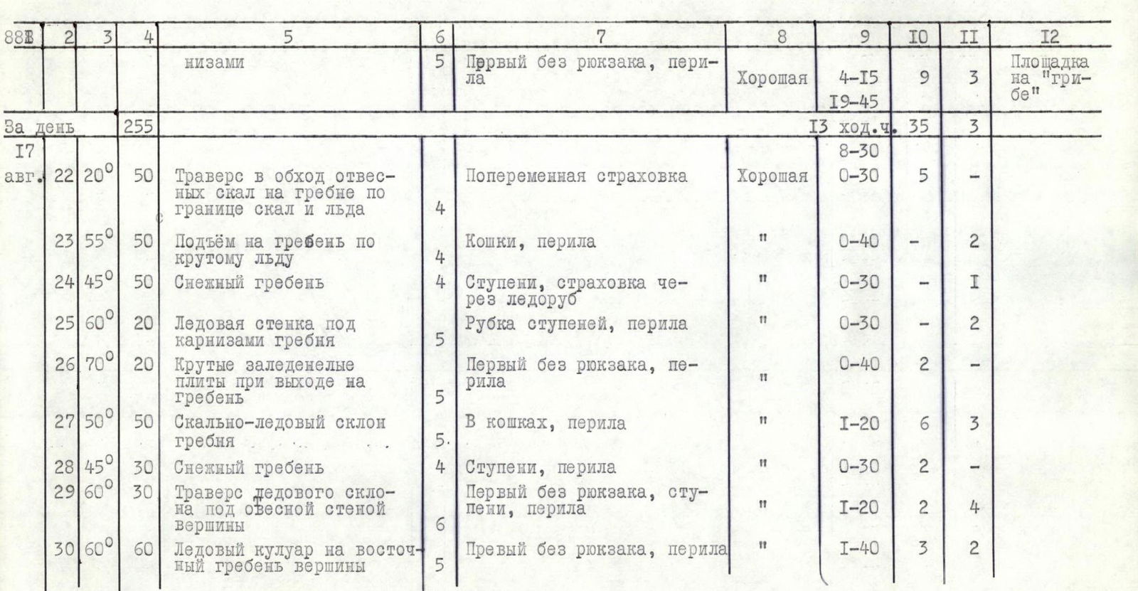
| № | Section | Average Steepness | Length, m | Section Characteristics and Passage Conditions | Cat. Diff. | Method of Overcoming and Belaying | Weather Conditions | Time of Exit — Stop (Climbing Hours) | Pitons (Rock) | Pitons (Ice) | Bivouac Conditions |
|---|---|---|---|---|---|---|---|---|---|---|---|
| August 15 | |||||||||||
| 12 | R12 | 45° | 30 | Bypassing the rock wall, stepped rocks | 3 | Processing from the evening before, fixed rope | Rain | 0:15 | 1 | – | |
| 13 | R13 | 75° | 100 | Rock wall of steep blocks and slabs | 5 | First without backpack, double rope, fixed rope | Rain | 1:45 | 12 | – | |
| 14 | R14 | 80° | 30 | Inner corner of smooth slabs | 6 | Artificial holds, ascent on étriers, rucksack retrieval | Rain | 1:30 | 4 | – | |
| 15 | R15 | 80° | 10 | Horizontal traverse under overhanging rocks | 5 | Fixed rope | Overcast | 0:30 | 3 | – | |
| 16 | R16 | 75° | 50 | Steep blocky rocks, smooth forehead and vertical "knife" | 6 | Artificial holds, fixed rope on étriers and rucksack retrieval | Overcast | 2:00 | 7 | – | Platform on a snow "mushroom" |
| For the day | 220 | 6:27 |
| № | Section | Average Steepness | Length, m | Section Characteristics and Passage Conditions | Cat. Diff. | Method of Overcoming and Belaying | Weather Conditions | Time of Exit — Stop (Climbing Hours) | Pitons (Rock) | Pitons (Ice) | Bivouac Conditions |
|---|---|---|---|---|---|---|---|---|---|---|---|
| August 16 | |||||||||||
| 17 | R17 | 85° | 45 | Steep blocky rocks with inner corner and overhangs | 6 | Processing from the evening before, ladders, fixed rope, double rucksack retrieval | Good | 3:00 | 12 | – | |
| 18 | R18 | 80° | 10 | Horizontal traverse on smooth slabs | 5 | Fixed rope | Good | 0:15 | 3 | – | |
| 19 | R19 | 90° | 20 | Ascent on large blocks through overhangs to the edge of the bastion | 6 | Artificial holds, fixed rope, étriers, rucksack retrieval | Good | 4:00 | 9 | – | |
| 20 | R20 | 50° | 30 | Smooth slabs along the edge of the bastion | 5 | Fixed rope, first without backpack | Good | 1:30 | 2 | – | |
| 21 | R21 | 60° | 150 | Snow-rock ridge with delicate cornices | 5 | First without backpack, fixed rope | Good | 4:15 | 9 | 3 | Platform on a "mushroom" |
| For the day | 255 | 13:00 | 35 | 3 |
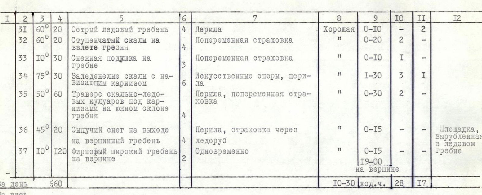
| № | Section | Average Steepness | Length, m | Section Characteristics and Passage Conditions | Cat. Diff. | Method of Overcoming and Belaying | Weather Conditions | Time of Exit — Stop (Climbing Hours) | Pitons (Rock) | Pitons (Ice) | Bivouac Conditions |
|---|---|---|---|---|---|---|---|---|---|---|---|
| August 17 | |||||||||||
| 22 | R22 | 20° | 50 | Traverse to bypass steep rocks on the ridge along the boundary of rocks and ice | 4 | Alternate belay | Good | 0:30 | 5 | – | |
| 23 | R23 | 55° | 50 | Ascent to the ridge on steep ice | 4 | Crampons, fixed rope | Good | 0:40 | – | 2 | |
| 24 | R24 | 45° | 50 | Snow ridge | 4 | Steps, belay via ice axe | Good | 0:30 | – | 1 | |
| 25 | R25 | 60° | 20 | Ice wall under cornices on the ridge | 5 | Step cutting, fixed rope | Good | 0:30 | – | 2 | |
| 26 | R26 | 70° | 20 | Steep frozen slabs at the exit to the ridge | 5 | First without backpack, fixed rope | Good | 0:40 | 2 | – | |
| 27 | R27 | 50° | 50 | Rock-ice slope on the ridge | 5 | Crampons, fixed rope | Good | 1:20 | 6 | 3 | |
| 28 | R28 | 45° | 30 | Snow ridge | 4 | Steps, fixed rope | Good | 0:30 | 2 | – | |
| 29 | R29 | 60° | 30 | Traverse of the ice slope under the steep wall of the peak | 6 | First without backpack, steps, fixed rope | Good | 1:20 | 2 | 4 | |
| 30 | R30 | 60° | 60 | Ice couloir to the east ridge of the peak | 5 | First without backpack, fixed rope | Good | 1:40 | 3 | 2 | |
| 31 | R31 | 60° | 20 | Sharp ice ridge | 4 | Fixed rope | Good | 0:10 | – | 2 | |
| 32 | R32 | 60° | 20 | Stepped rocks on the ascent of the ridge | 4 | Alternate belay | Good | 0:20 | 2 | – | |
| 33 | R33 | 10° | 30 | Snow cushion on the ridge | 3 | Alternate belay | Good | 0:10 | 1 | – | |
| 34 | R34 | 75° | 30 | Frozen rocks with overhanging cornice | 6 | Artificial holds, fixed rope | Good | 1:30 | 3 | 1 | |
| 35 | R35 | 50° | 60 | Traverse of rock-ice couloirs under cornices on the south slope of the ridge | 4 | Fixed rope, alternate belay | Good | 0:30 | 2 | – | |
| 36 | R36 | 45° | 20 | Loose snow on the exit to the summit ridge | 4 | Fixed rope, belay via ice axe | Good | 0:15 | – | – | Platform carved in the ice ridge |
| 37 | R37 | 10° | 120 | Firn wide ridge on the summit | 2 | Simultaneous | Good | 0:15 | – | – | |
| For the day | 660 | 10:30 | 28 | 17 | |||||||
| For the entire route | 1765 | Of which 5 and 6 cat. diff. 875 m. | 44 climbing hours | 125 rock | 29 ice pitons |
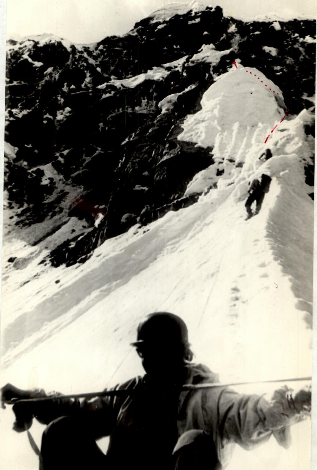
On fixed ropes on the "delicate" ridge. Section R21.
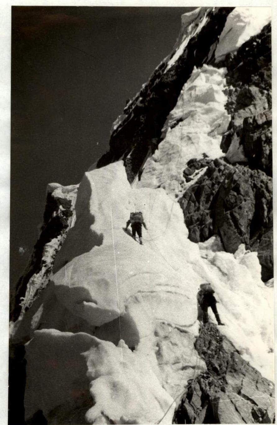
Snow ridge. Section R24. Ahead is the ice wall. Section R25.
At the summit by the cairn.

Comments
Sign in to leave a comment