ASCENT DOCUMENT
- Ascent class — High-altitude
- Ascent area, ridge — Akademii Nauk Ridge, Central Pamir
- Peak, its height, ascent route — p. Rossiya 6852 m via the Bastion on the SE wall
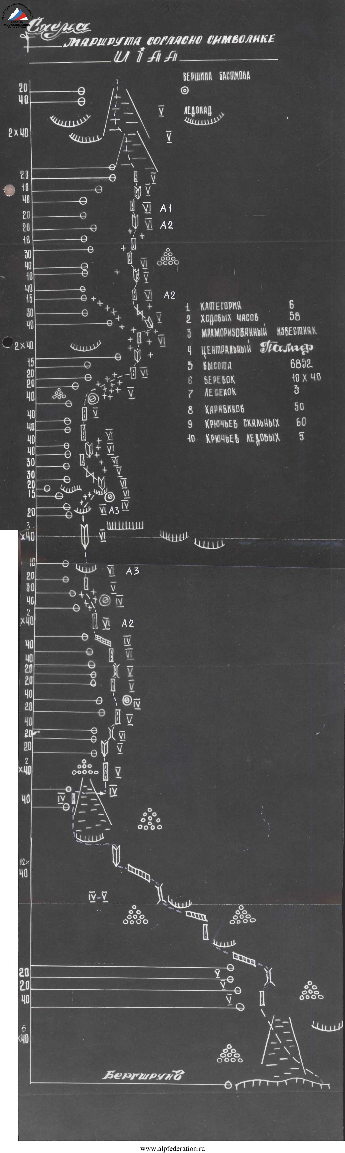
- Proposed difficulty category — 6
- Route characteristics:
- Height difference — 2050 m, Bastion height difference — 1150 m, "lap" — 800 m
- Length of sections with 5–6 difficulty category — 1460 m
- Average steepness of the "lap" — 55°, average steepness of the Bastion — 75–80°, average steepness of the route — 70°
- Number of pitons: for belaying: rock — 236, ice — 7, "chocks" — 40; for creating Intermediate Technical Objects (ITO) — 10
- Number of climbing hours — 58 hours
- Number of bivouacs and their characteristics — 4 "sitting", 4 "lying", including 3 on the dome at an altitude of 6700 m
- Full name of the team leader, participants, and their qualifications:
- Ilyinsky Ervand Tikhonovich — Master of Sports (MS) — team leader
- Valiev Kazbek Shakimovich — MS — participant
- Golodov Yuri Fedorovich — MS — participant
- Krutilov Oleg Evgenievich — Candidate for Master of Sports (CMS) — participant
- Lunyakov Grigory Evgenievich — CMS — participant
- Panteleev Nikolai Vladimirovich — CMS — participant
- Smirnov Vadim Anatolievich — Master of Sports of International Class (MSMK) — participant
- Khrischaty Valery Nikolaevich — MS — participant
- Chepchev Sergey Georgievich — MS — participant
- Shkarban Viktor Vladimirovich — CMS — participant
- Team coach — Ilyinsky E.T., Honored Coach of the USSR, MS
- Date of departure and return: July 31, 1979 – August 9, 1979
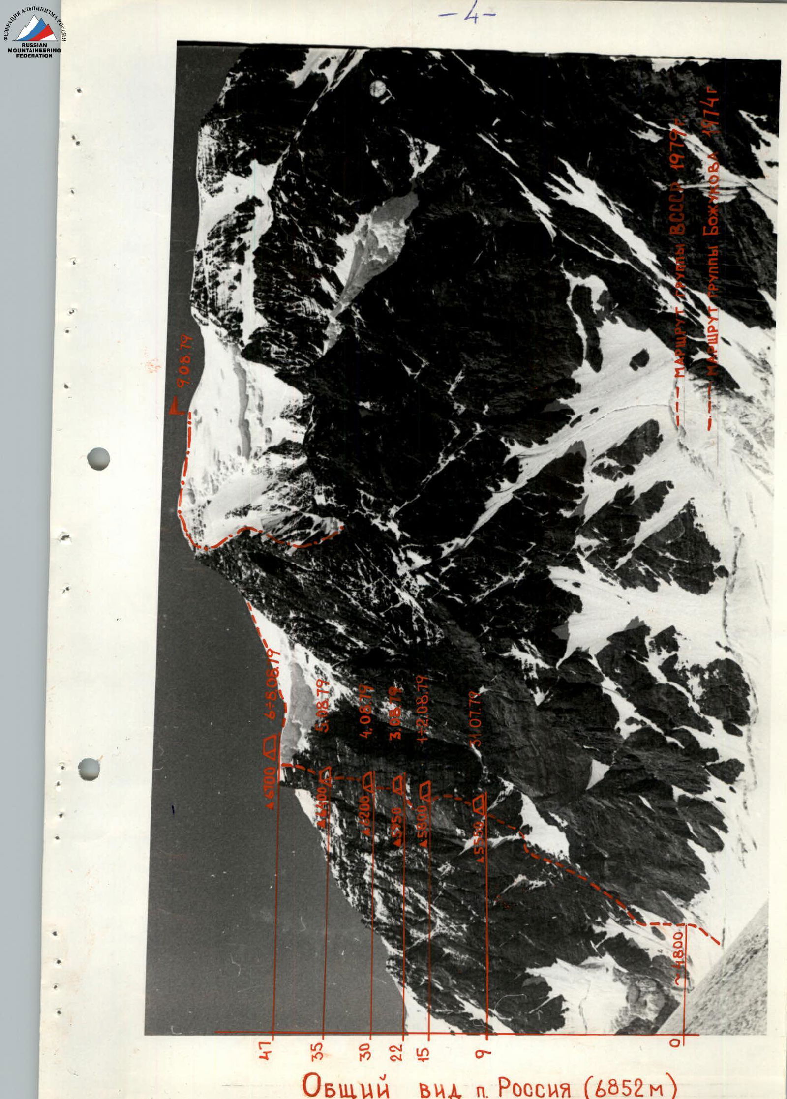
Peak Rossiya (6852 m) is located in the Akademii Nauk Ridge, Central Pamir, east of Peak Kommunizma.
The first ascent to the summit of Peak Rossiya was made by a team from the Georgian Alpine Club led by M. Gvarliani.
For the ascent to Peak Rossiya from l. Belyaeva in 1955, the team was awarded silver medals in the USSR Championship.
Other significant ascents
- In 1974, a team from the Moscow "Burevestnik" led by V. Bozhukov climbed the right edge of the southeast wall of Peak Rossiya and took third place in the USSR Championship.
- In 1977, a team from the Sverdlovsk Regional Sports Committee for Physical Culture and Sports made an ascent via the center of the western wall under the leadership of S. Efimov and won bronze medals in the Union championship.
The first acquaintance with the southeast wall of Peak Rossiya occurred in 1974 through photographs. Then, in 1976, we had the opportunity to photograph and see this wall. In 1979, two reconnaissance helicopter flights уточn the ascent route via the most interesting part of the southeast wall — the Bastion.
Brief description of the approaches to the route
The base camp, located on the right lateral moraine of l. Bivachny, was delivered by a helicopter from the Kyrgyz aviation unit. Here, on the western slopes of peak 5966, located north of the OGPU peak, there is a large, good, flat pocket of lateral moraine, which has a convenient area for helicopter landing and camp setup. This is spending the highest green area.
From the base camp, the team:
- walked for one hour along the right lateral moraine of l. Bivachny to the northern slopes of the OGPU peak;
- crossed l. Bivachny;
- continued along the left pocket of the glacier and the lateral moraine towards l. Krutoy.
The observation camp was set up on the right side of l. Krutoy under the eastern slopes of peak 5862. Along the center of l. Krutoy, the team approached the southeast wall of Peak Rossiya in two hours. The entire approach from the base camp to the route took 8 hours.
Brief explanation of the table
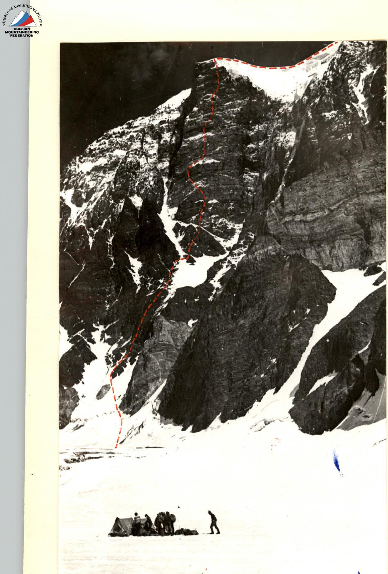
On July 31, the first five members began the ascent. At 6:00, they crossed the bergschrund to the right via a bridge and traversed a wide, steep ice couloir to the left to a small rock protruding from the ice with a white color.
From here:
- they ascended via ice under a steep rock step, which they overcame from left to right via difficult rocks. Climbing was very difficult at times, with rocks covered in rime ice and heavily destroyed. It was cold.
- from the bend of the rock step, they proceeded along the left rock edge of the snow-ice couloir straight up. The rocks were of medium difficulty, heavily destroyed, and occasionally featured small rock walls, ledges, and cornices. It was rockfall-prone. Most rocks and ice fell from above the wall via the couloir. Movement was alternating, via fixed ropes, due to the rockfall hazard.
By 14:00, they reached the throat of the couloir. Here, they had lunch and crossed the couloir to the right to a small island below the Bastion.
Further:
- they ascended left — up via a destroyed rock wall to a wide shelf.
- beyond it, another wall.
- then, via a destroyed rock rib to the top of the island.
On its right side, they chose a location for the first night's bivouac on the wall. 18:00.
On August 1, the second five members departed from l. Krutoy following the same schedule. At 10:00, the first five began processing the lower part of the Bastion. Initially, the rocks were heavily destroyed, followed by monolithic sections with rare outcrops. Climbing was done in calks. A steep rock rib led to an osypnaya (scree) shelf. From here, a complex, sheer wall ascent was made left — up. The first climber used double rope and calks. They utilized:
- eccentric pitons,
- cams,
- and used ladders.
After the wall, there were destroyed, non-steep rocks, followed by a large, protruding balcony from the Bastion. On its lower left side, there was a suitable location for a sitting bivouac, protected by a cornice. Above the bivouac site, there were complex, slab-like rocks with a cornice at the top, which was passable using ladders. The processing was completed. This five-member team then moved along the
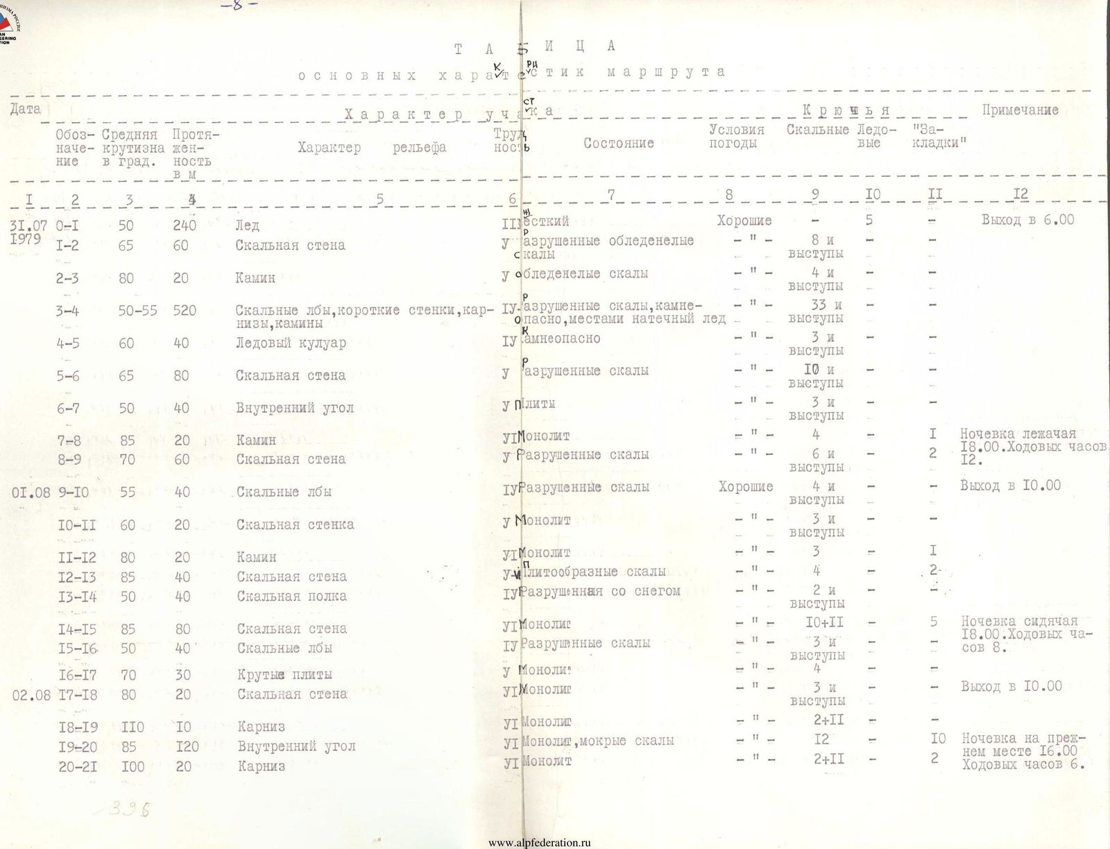
| Date | Designation | Average steepness in ° | Length in m | Terrain character | Difficulty | Condition | Weather conditions | Rock Pitons | Ice | Chocks | Notes |
|---|---|---|---|---|---|---|---|---|---|---|---|
| 31.07.1979 | R0–R1 | 50 | 240 | Ice | Mixed | Good | 5 | – | – | Departure at 6:00 | |
| R1–R2 | 65 | 60 | Rock wall | Destroyed, icy rocks | – " – | 8 and ledges | – | – | |||
| R2–R3 | 80 | 20 | Chimney | Icy rocks | – " – | 4 and ledges | – | – | |||
| R3–R4 | 50–55 | 520 | Rock ledges, short walls, cornices, chimneys | Destroyed rocks, rockfall-prone, some rime ice | – " – | 33 and ledges | – | – | |||
| R4–R5 | 60 | 40 | Ice couloir | Rockfall-prone | – " – | 3 and ledges | – | – | |||
| R5–R6 | 65 | 80 | Rock wall | Destroyed rocks | – " – | 10 and ledges | – | – | |||
| R6–R7 | 50 | 40 | Internal corner | Slabs | – " – | 3 and ledges | – | – | |||
| R7–R8 | 85 | 20 | Chimney | Monolith | – " – | 4 | – | 1 | Lying bivouac 18:00. Climbing hours 12. | ||
| R8–R9 | 70 | 60 | Rock wall | Destroyed rocks | – " – | 6 and ledges | – | 2 | |||
| 01.08 | R9–R10 | 55 | 40 | Rock ledges | Destroyed rocks | Good | 4 and ledges | – | – | Departure at 10:00 | |
| R10–R11 | 60 | 20 | Rock wall | Monolith | – " – | 3 and ledges | – | – | |||
| R11–R12 | 80 | 20 | Chimney | Monolith | – " – | 3 | – | 1 | |||
| R12–R13 | 85 | 40 | Rock wall | Slab-like rocks | – " – | 4 | – | 2 | |||
| R13–R14 | 50 | 40 | Rock shelf | Destroyed with snow | – " – | 2 and ledges | – | – | |||
| R14–R15 | 85 | 80 | Rock wall | Monolith | – " – | 10+11 | – | 5 | Sitting bivouac 18:00. Climbing hours 8. | ||
| R15–R16 | 50 | 40 | Rock ledges | Destroyed rocks | – " – | 3 and ledges | – | – | |||
| R16–R17 | 70 | 30 | Steep slabs | Monolith | – " – | 4 | – | – | |||
| 02.08 | R17–R18 | 80 | 20 | Rock wall | Monolith | – " – | 3 and ledges | – | – | Departure at 10:00 | |
| R18–R19 | 110 | 10 | Cornice | Monolith | – " – | 2+11 | – | – | |||
| R19–R20 | 85 | 120 | Internal corner | Monolith, wet rocks | – " – | 12 | – | 10 | Bivouac at previous location 16:00. Climbing hours 6. | ||
| R20–R21 | 100 | 20 | Cornice | Monolith | – " – | 2+11 | – | 2 | |||
| 03.08 | Passed processed sections from R17 to R21 from 9:00 to 13:00 | ||||||||||
| R21–R22 | 50 | 40 | Rock ledges | Destroyed with snow | Good | 3 and ledges | – | – | |||
| R22–R23 | 110 | 15 | Cornice | Monolith | – " – | 3 | – | 3 | |||
| R23–R24 | 90 | 20 | Internal corner | Monolith | – " – | 3 | – | 2 | |||
| R24–R25 | 85 | 30 | Diagonal crack | Monolith | – " – | 4 | – | 2 | |||
| R25–R26 | 80 | 30 | Wall | Monolith | – " – | 6 | – | – | |||
| R26–R27 | 90 | 20 | Internal corner | Monolith | – " – | 3 | – | 2 | |||
| R27–R28 | 85 | 50 | Wall | Monolith | – " – | 7 | – | 2 | |||
| R28–R29 | 60 | 40 | Rock ledges | Destroyed | – " – | 3 and ledges | – | – | Sitting bivouac 17:00. Climbing hours 8. | ||
| 04.08 | Passed processed sections from R22 to R29 from 11:00 to 14:00. Snowfall at night, visibility 20 m in the morning. | ||||||||||
| R29–R30 | 65 | 60 | Rock ledges | Destroyed, snow-covered | Fog, snow | 4 and ledges | – | – | |||
| R30–R31 | 80 | 20 | Wall | Monolith | Snowfall | 4 | – | – | |||
| R31–R32 | 95 | 25 | Internal corner | Monolith | – " – | 6 | – | – | |||
| R32–R33 | 75 | 80 | Wall | Polished rocks | – " – | 12 | – | 1 | |||
| R33–R34 | 80 | 40 | Internal corner | Destroyed rocks | – " – | 6 and ledges | – | 2 | |||
| R34–R35 | 75 | 30 | Diagonal crack | Destroyed rocks | – " – | 4 and ledges | – | – | |||
| R35–R36 | 90 | 15 | Wall | Monolith | – " – | 3+1 | – | 2 | |||
| R36–R37 | 70 | 45 | Internal corner | Monolith, polished rocks | – " – | 7 | – | – | Sitting bivouac 18:00. Climbing hours 7. | ||
| 05.08 | Passed processed sections from R30 to R37 from 10:00 to 14:00 | ||||||||||
| R37–R38 | 80 | 10 | Wall | Monolith | Snowfall | 2 | – | – | |||
| R38–R39 | 65 | 40 | Destroyed rocks | Snow-covered | – " – | 3 and ledges | – | – | |||
| R39–R40 | 90 | 30 | Wall | Monolith | – " – | 5 | – | – | |||
| R40–R41 | 95 | 10 | Internal corner | Monolith | – " – | 2+1 | – | 2 | Sitting bivouac 18:00. Climbing hours 8. | ||
| R41–R42 | 90 | 20 | Wall | Monolith | – " – | 3+11 | – | – | |||
| 06.08 | Passed processed sections from R38 to R42. Departure at 8:00. Snowfall at night, visibility 20 m in the morning. | ||||||||||
| R42–R43 | 80 | 20 | Wall | Destroyed, icy rocks | Snowfall | 3 and ledges | – | – | |||
| R43–R44 | 70 | 50 | Internal corner | Destroyed, icy rocks | – " – | 6 | – | – | |||
| R44–R45 | 70 | 20 | Wall | Destroyed, icy rocks | – " – | 3 and ledges | – | – | |||
| R45–R46 | 70 | 80 | Couloir | Icy slabs | – " – | 6 and ledges | – | – | |||
| 07.08 | R46–R47 | 75 | 60 | Couloir | Rocks covered in ice | Snowfall | 4 and ledges | – | – | Lying bivouac on snow dome 18:00. Climbing hours 8. | |
| R47–R48 | 55 | 60 | Snow-ice slope | Hard ice | – " – | 2 | – | – |
Total: 236 rock pitons, 7 ice screws, 40 chocks. 58 hours (first team's work).
By 18:00, the entire team reached the dome. Fog and snowfall continued. Visibility was 20 m. We bivouacked on snow. Altitude 6700 m.
August 7. Snow fell throughout the night. Fog and snowfall in the morning. Strong wind. We departed at 10:00. Visibility was zero. We walked for 20 minutes. There was a lot of snow, and it was avalanche-prone. We decided to return to the bivouac site. We waited in tents for visibility to improve. Visibility did not improve throughout the day. We bivouacked in the same location.
August 8. At 8:00, the sun peeked through the gaps in the clouds. We quickly packed up and departed along the wide snow ridge bounding the plateau under Peak Rossiya from the west. We approached the slope of the peak at 10:00. Visibility was 20–30 m. It was avalanche-prone. The ascent path was unclear. Strong gusty wind. Cold. At 11:00, we set up tents again and waited for visibility to improve. The bad weather continued until evening. We bivouacked there.
August 9. 9:00. The weather improved. Sun, but strong to stormy wind. Very cold. We climbed the snow slope straight up and reached the summit ridge. At 11:30, our team reached the summit of Peak Rossiya.
Team captain and coach 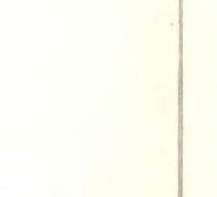 (E.T. Ilyinsky)
Information about reconnaissance flights and airdrops
For reconnaissance purposes, two helicopter flights were made on July 15 and 26 to the upper reaches of l.l. Bivachny and Krutoy.
During the second flight on July 26, a supply drop was made slightly higher up l. Krutoy from the confluence with l. Bivachny. The airdrop contained food for the observation group and some equipment for the climbing team. On board the helicopter during this flight were: Ilyinsky, Sevastyanov, Ovchinnikov, Valiev, and Smirnov.
Before the team's departure directly to the route on July 30, a reconnaissance trip was made under the wall by the Smirnov–Khrischaty team to determine the rockfall regime of the lower part of the wall and the condition of the beginning of the route. The middle and upper parts were studied by team members using 8× binoculars from a temporary camp located on l. Krutoy, a 50–60-minute walk under the start of the route. Information received via radio from observers, who viewed the wall through 30× and 60× telescopes, was also taken into account.
Tactics of the ascent
The ascent route — the "Bastion" on the southeast wall of Peak Rossiya — can be divided into two parts:
- The first — upper part — is the steepest;
- The second — lower part — is less steep but more dangerous regarding rockfall.
Therefore, the ascent tactics were structured as follows: one tent (five people) began moving along the lower part of the wall towards the "Bastion" on July 31 and started processing its lower part on August 1. On August 1, 1979, the second tent ascended to under the "Bastion" and joined the first on August 2. The group's work was structured as follows: in the morning, they moved along fixed ropes to the planned bivouac site. Ropes were fixed the previous afternoon. After all participants reached the end of the ropes, a team of three to four people began processing the route further. The rest prepared sites for tent setup.
During the ascent, the team used:
- a new type of ascender designed by team member MS V. Polonov;
- variously shaped chocks;
- an extractor, which allowed increasing the multiplicity of piton use on the route;
- various slings;
- "Irbis" carabiners.
Special packaging of food into polyethylene bags using a "Molniya" sealer was applied.
Observation group composition
- Bergman S.P. — MS
- Turkevich M.M. — CMS
- Frolov P.E. — 1st category
- Feofanov A.V. — 2nd category
The observation group consisted of four people divided into two pairs: Bergman–Turkevich and Frolov–Feofanov. The pairs took turns observing. Observers were supplied with necessary food, 30× and 60× telescopes, and 8× binoculars. For communication with the climbing team and base, observers used VHF radios.
Total weight of food and equipment
Lightweight backpacks, down and feather clothing, lightweight high-altitude tents — special order, pitons, carabiners, chocks made from lightweight alloys, petrol cans with 0.5-liter capacity, portable VHF radios significantly helped the team during the wall ascent.
Thanks to the use of such equipment and careful selection of food, the public load in a backpack did not exceed 10.5 kg per participant.
In total, for the planned 10 days of ascent, the team took:
- 46.5 kg of food
- 58.2 kg of public equipment.
Notes from the summit and control points
On August 9, 1979, the team retrieved a note from the summit of Peak Rossiya left by a team from the Sverdlovsk Regional Sports Committee for Physical Culture and Sports led by Efimov O.B. on August 17, 1977.

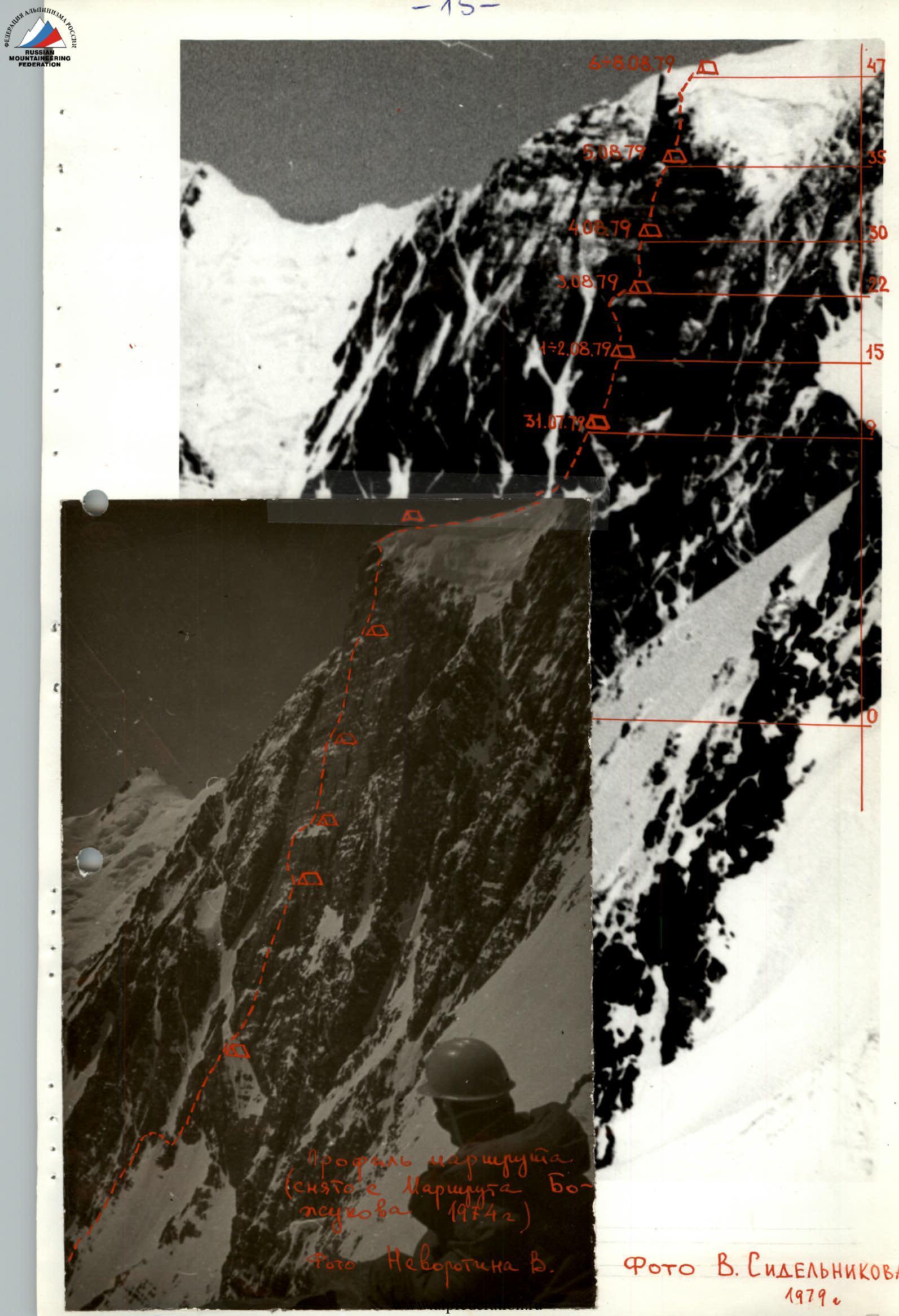
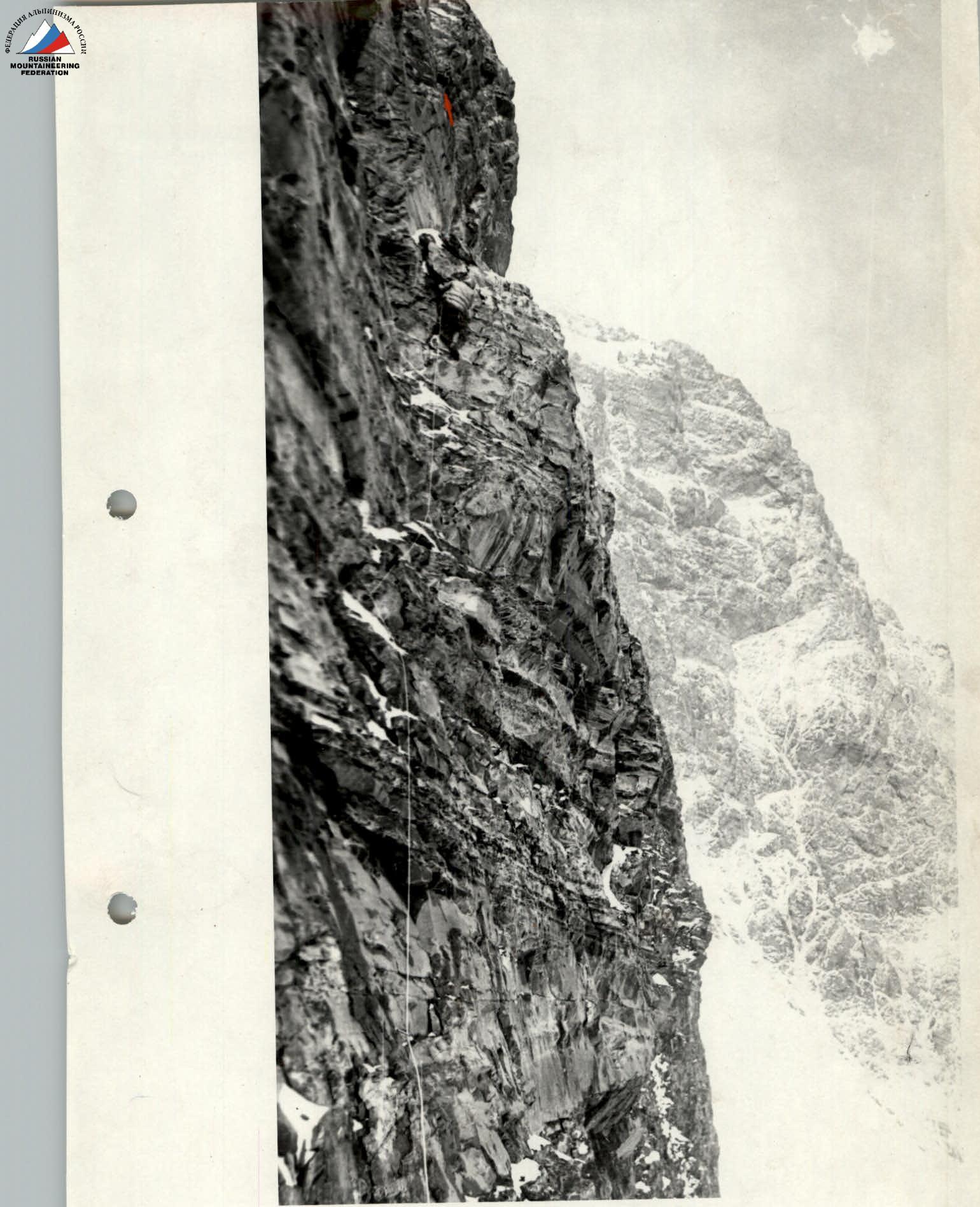
On section R12–R13
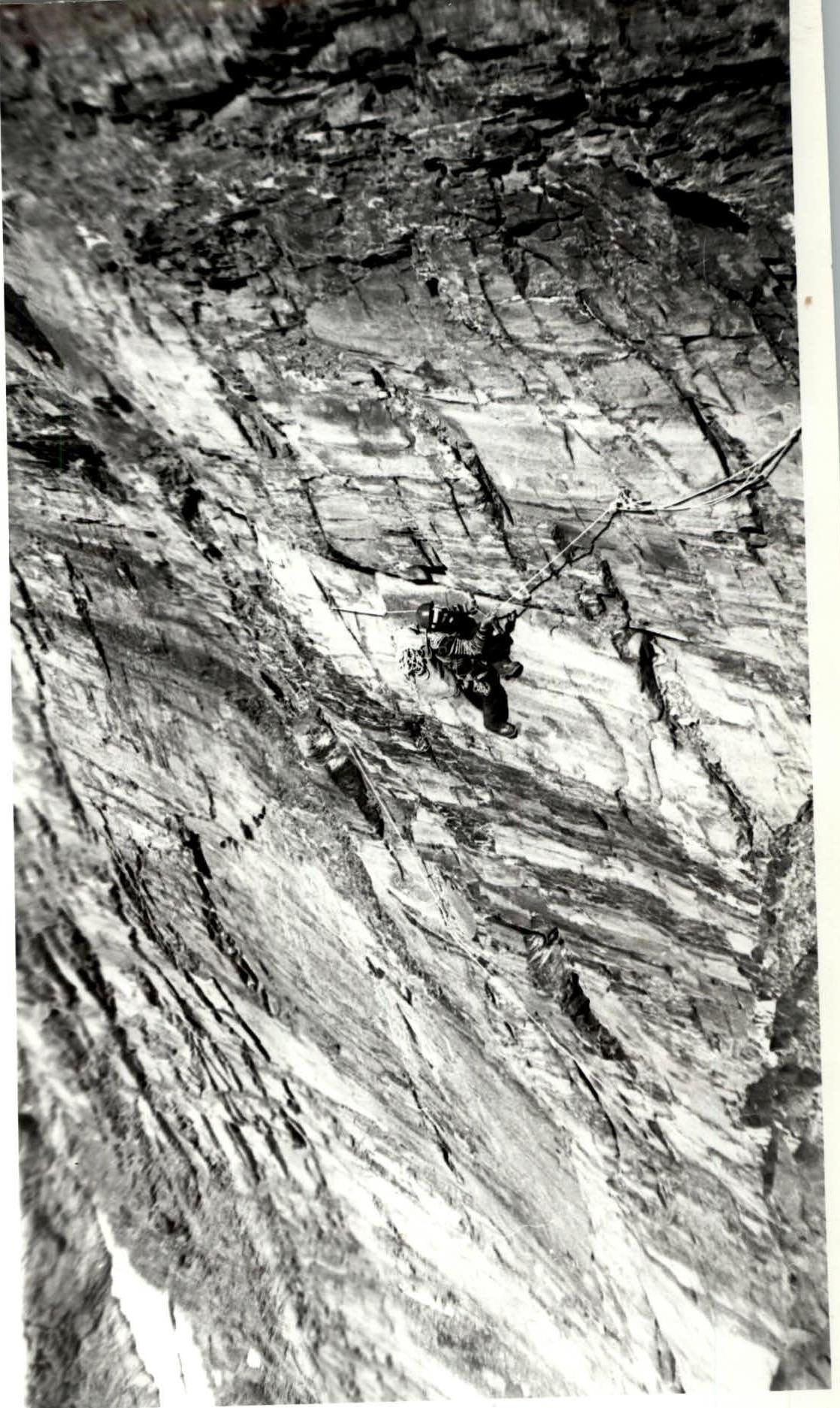
On section R14–R15 (top view)
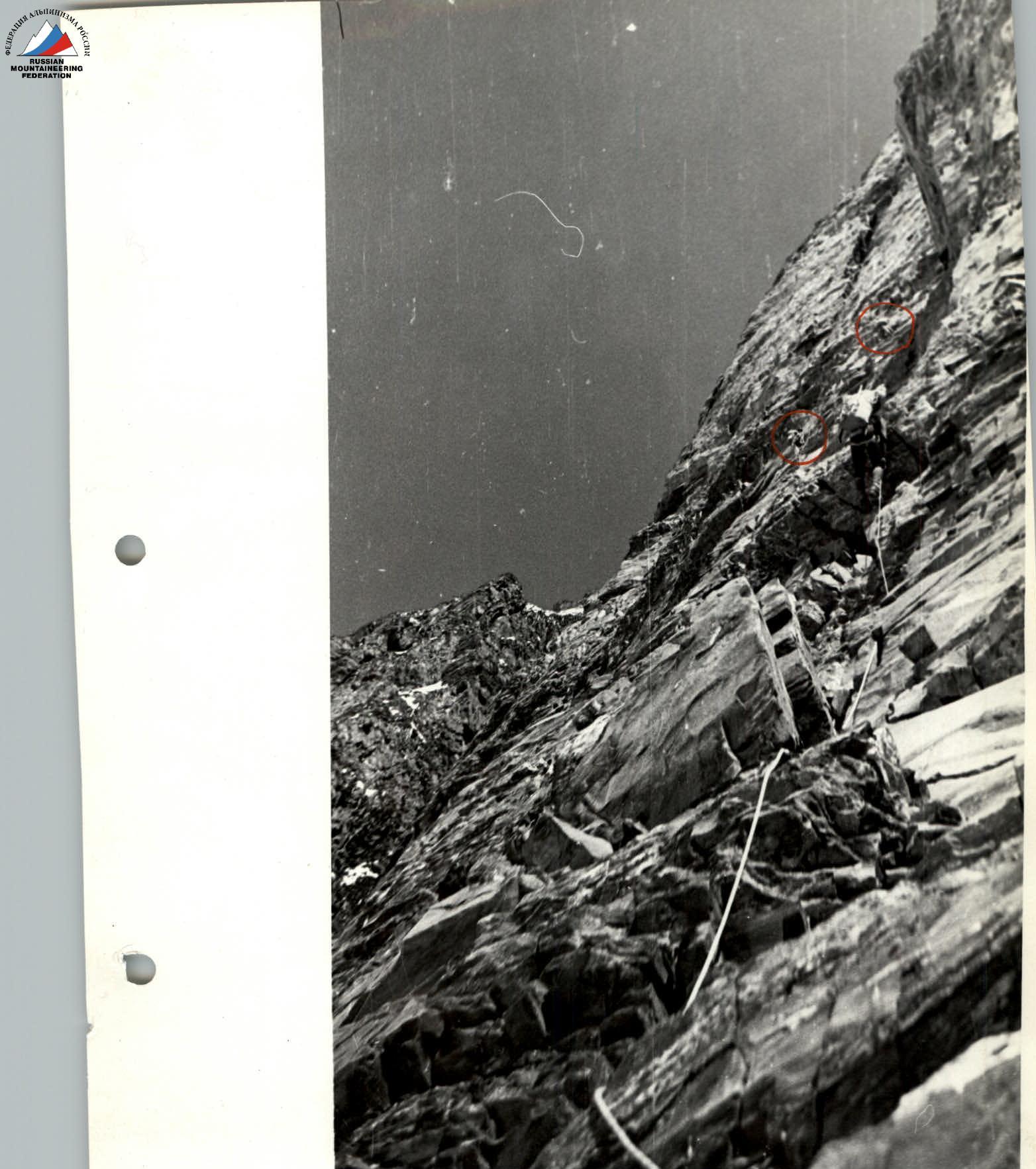
Ropes on section R17–R20
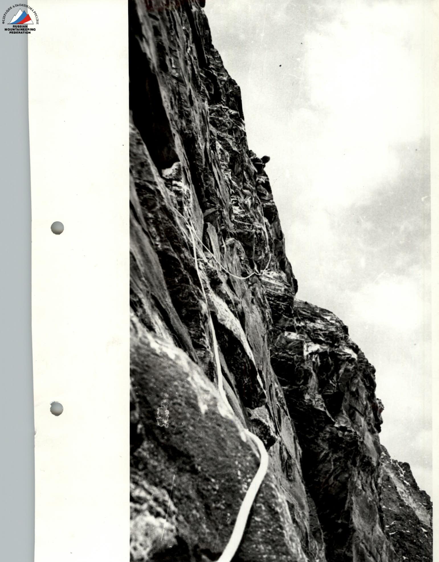
On section R27–R28
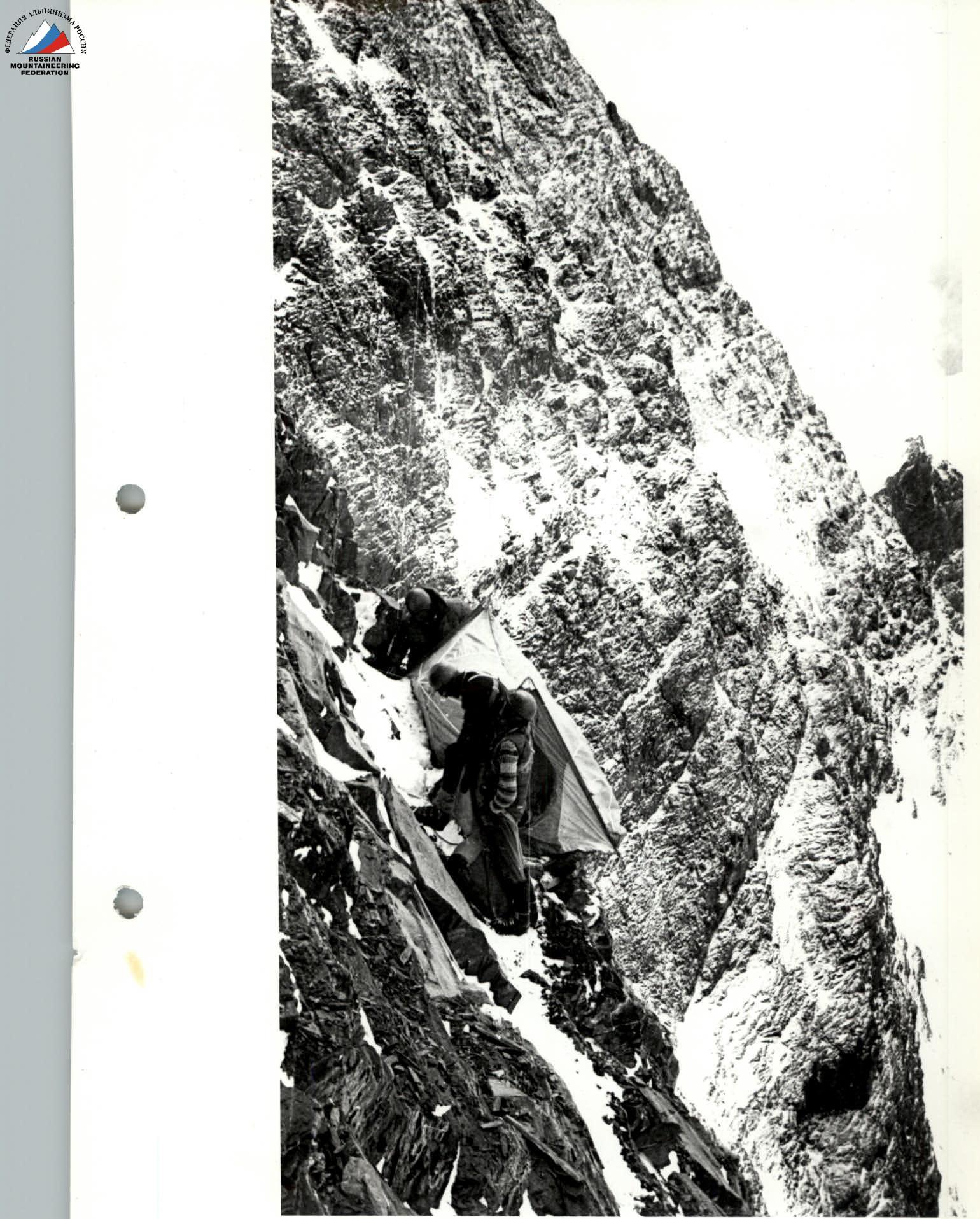
Bivouac №5
On section R39–R40