Peak Kosmonavtov
The 5800 m summit (4th Western peak of the Fedchenko Glacier) is located in the Marx-Engels Ridge, situated between the Bivachny Glacier and the Fedchenko Glacier opposite the confluence of the Kalinin Glacier and the Bivachny Glacier.
From the Bivachny Glacier side:
- The northern slopes of the summit are covered with steep scree in the lower part and are cut by steep couloirs and buttresses in the upper part.
- The western slopes face a vast inner cirque filled with a glacier, whose tongue hangs into a couloir and is visible from the Bivachny Glacier.
- The ice is steep and of an overhanging nature.
Between the 5800 m summit and the next peak to the west, there is a snowy saddle in the ridge. The snow layer is thin and lies on ice. The slopes facing the Fedchenko Glacier are very steep and rocky.
The western ridge of the summit consists of three rises descending to the saddle.
The ridge rocks are heavily destroyed, composed of fibrous rocks. Pitons hold poorly.
On the first day, the group, leaving the 3800 m camp, descended along the Bivachny Glacier via a caravan trail for 1 hour to the slopes of the summit and began ascending steep scree towards the inner cirque.
Ascending the couloir into which the glacier tongue hangs is hazardous due to the risk of being hit by falling rocks and ice chunks. In the lower part, the glacier body ends with sheer 10-meter walls.
Having ascended via the "barranji lby" along the glacier, we reached a point where it was possible to ascend onto the glacier. After roping up and putting on crampons, we began ascending the glacier. Movement occurred on the front points of the crampons, very cautiously, due to the unpleasant overhanging nature of the ice.
40 minutes after ascending onto the glacier, we managed to climb:
- to the first step, where the glacier becomes somewhat gentler and represents an inclined basin filled with rocks falling from the summit slopes;
- from there, crossing a series of crevasses, the group ascended to the second step - a small inflection of the ice slope;
- then we traversed left to a scree island under the snowy saddle, where we set up a bivouac.
We stopped for the night at 18:00.
Thus, on the first day, movement continued for 8 hours, of which:
- 1 hour - approach;
- 3 hours - movement across scree;
- 4 hours - movement across the glacier.
2nd day
After examining the further route, it became clear that the intended ascent route to the saddle and the ascent via the western ridge had significant drawbacks. Steep snow, lying in a thin layer on the ice, greatly slowed down the movement, requiring careful insurance on ice pitons.

At the same time, the possibility of ascending initially via a scree slope and then via buttresses to a small rock wall (150–200 m) leading directly to the second rise of the summit was clearly visible.
We left the bivouac at 8:00 and with backpacks began crossing the ice slope to the left, cutting steps in the overhanging ice, as crampon points held very poorly. Having reached the scree slope, we left our backpacks on a rock outcrop and went upwards, heading towards the rock wall.
The scree slope soon gave way to sections of rocks separated by couloirs. In the upper part, the couloirs were filled with ice and snow. Therefore, we had to ascend onto the rocks and proceed with careful, alternating insurance through outcrops.
It was difficult to hammer in a piton, as the rocks easily splintered. Near the rock wall, the buttress became very steep, and we had to descend into a couloir where a rope was tensioned for a sports ascent. Then followed two more ropes, which the first climber passed by climbing with lower insurance, and the rest ascended using the sports method.
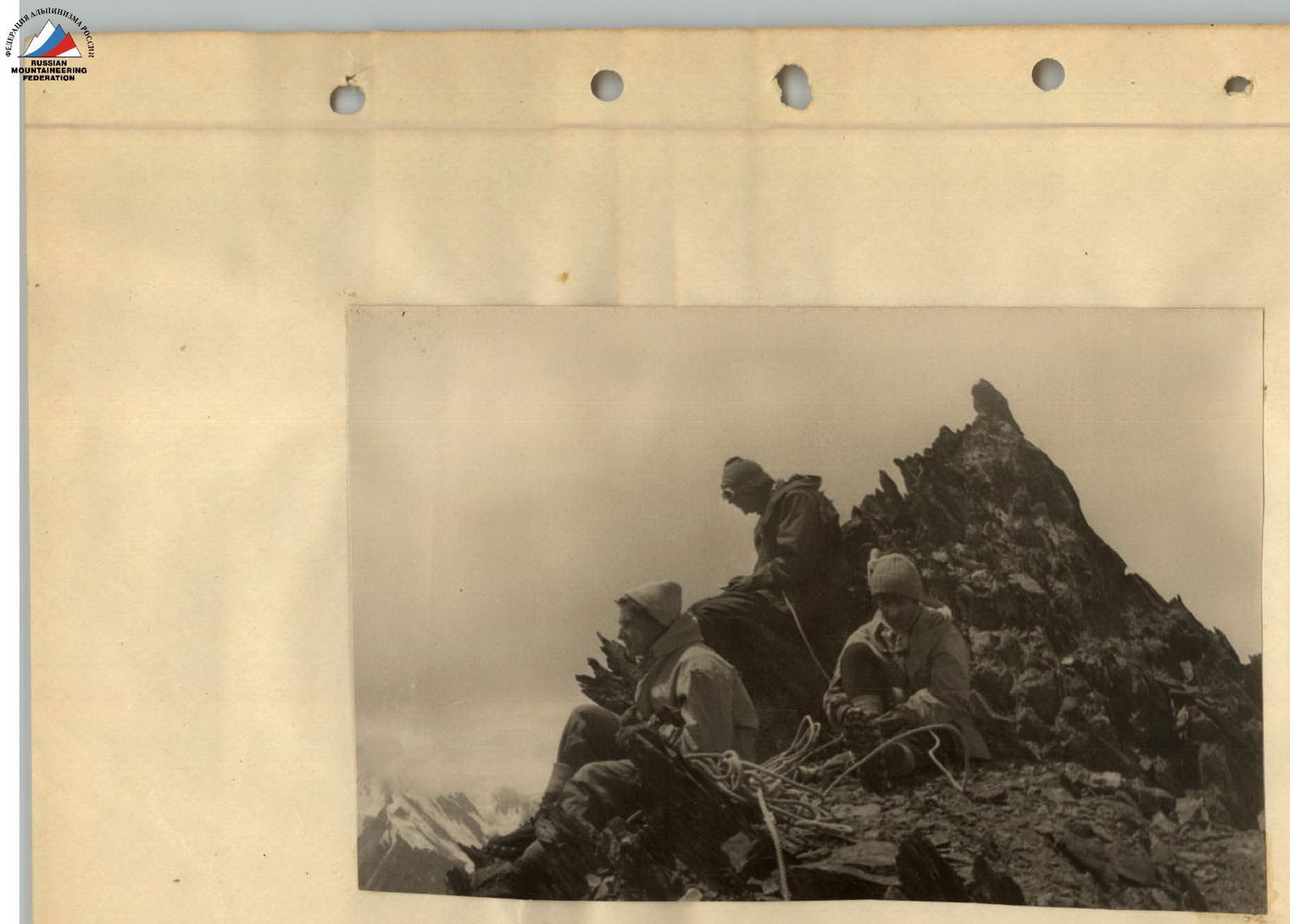
When we managed to lead all group members to a safe location from falling rocks, the first climber, moving forward on a rope, ascended to the ridge and received the others, who ascended using the sports method.

The further ascent to the main rise, representing the summit, was uncomplicated. At 14:00, we were at the summit, from where a beautiful view opened onto the Fedchenko Glacier, up to its turn from the Kashal-Ayak pass to the east and onto the area of Peak Stalin.
At this time, the weather worsened, and snow began falling in the form of dry grains, which melted and made the rocks wet and inconvenient for movement.
The descent proceeded mainly along the ascent route. The difficulties of the descent exceeded those of the ascent, as holds on the smooth, fragile rocks were small and held very poorly, and when descending face-to-the-slope, the foot easily slipped.
The descent, like the ascent, proceeded mainly using the sports method. Immediately after the first climber descended, an ice piton was hammered into the rocks, through which the last climber was reliably insured while descending by climbing. When descending through a couloir where the first fixed rope was set during the ascent, a piton with a loop was left, through which the last climber descended on a double rope, after which the rope was pulled through.
In total, 6 ropes of 40 m were set for the descent using the sports method. Movement was greatly delayed due to the difficulty of descending the last climber, who went by climbing. During the movement, the rope team changed places; participants within the teams swapped positions.
The last two sections of rocks presented particular difficulty when exiting onto the scree leading to the location where the backpacks were left. Here, it was necessary to transition from one buttress to another, crossing a couloir filled with ice and snow. It was necessary to proceed cautiously, cutting steps and using small rock islands.
On the last rock section, the descent proceeded along narrow, inclined ledges.
From the backpacks, it was decided to descend not onto the glacier but along a broad scree ridge, then via couloirs until they narrowed, and finally, by traversing left with crossing couloirs and exiting onto a broad, shallow scree leading to the foot of the summit.
However, this route cannot be recommended for ascent: the shallow scree slides down and holds poorly, making the ascent extremely tiring. Moreover, ascending via couloirs is hazardous due to falling rocks, which can be avoided thanks to a quick descent.
The group returned to the camp by 23:00, having worked for 15 hours that day. Of these:
- crossing the glacier - 2 hours;
- ascending the scree - 1 hour 30 minutes;
- passing the rock wall - 2 hours 30 minutes;
- descending to the backpacks - 4 hours;
- descending to the trail - 2 hours;
- ascending to the camp - 3 hours.
Considering the combined nature of the route (rocks, ice), the difficult work on crampons on the glacier (front points, cutting steps), and the steep, hazardous rocks of the summit wall (sports ascents, descents), the group evaluated the route as category 4B.
The summit can be recommended as a good training peak before ascending the main peaks of the area and as a good observation point.
The group proposed the name "Peak Kosmonavtov" for the summit.
Group composition:
- Efimov O.N. (leader) - II category;
- Zatrudina R.F. - II category;
- Goryacheva V.S. - II category;
- Simolin A. - II category.
Before ascending Peak Kosmonavtov, the participants ascended a number of peaks in the area of Peak Stalin.


