Climbing Passport
-
Climbing category — high-altitude.
-
Climbing area — Central Pamir, Akademiya Nauk Range.
-
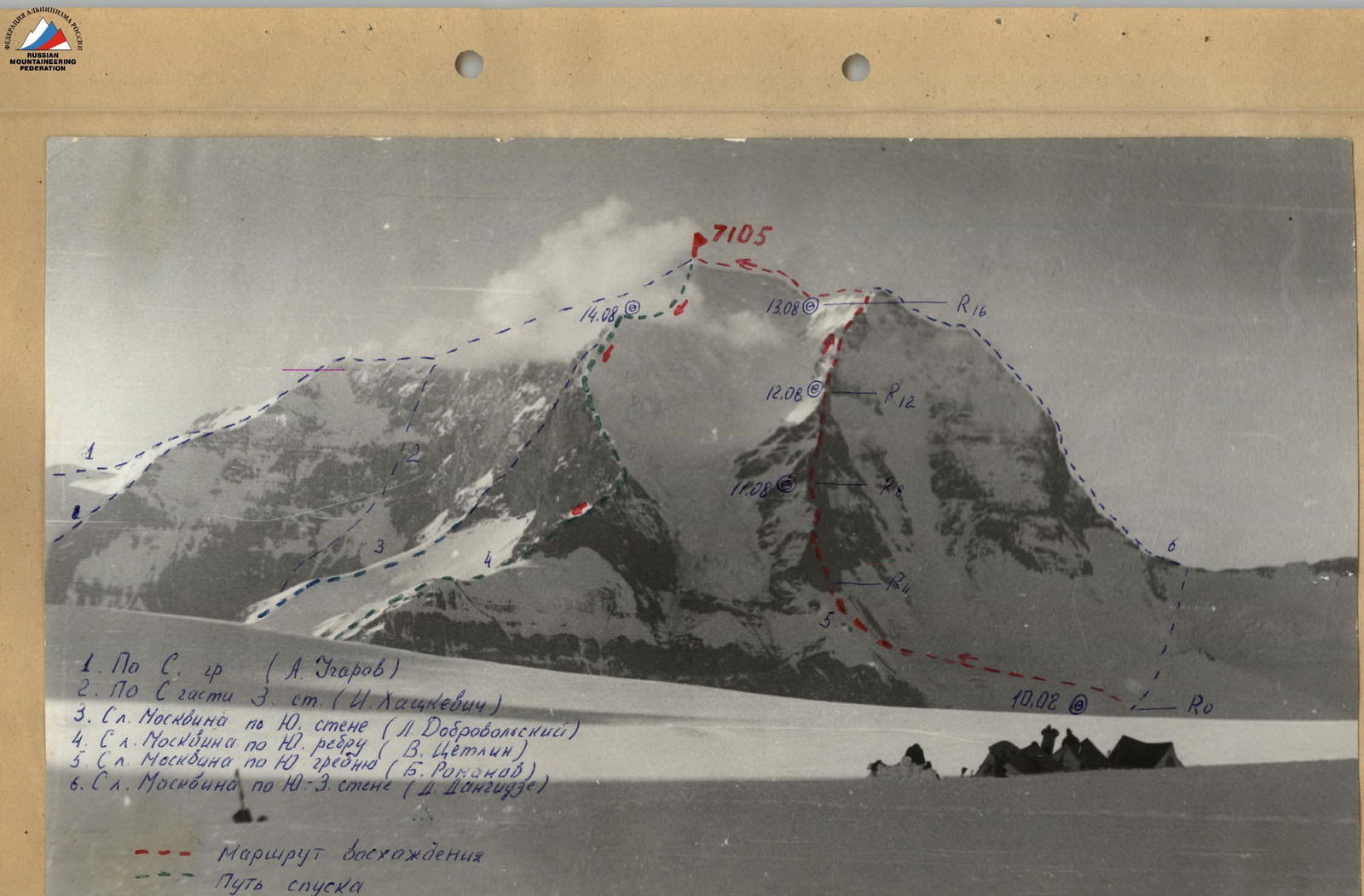
Peak — Peak "E. Korzhenevskoi" 7105 m, via the South Ridge from Moskvin Glacier.
-
Difficulty category — 5B.
-
Route characteristics: height difference 4200–7105 m, section length 5 km – 60 m, average steepness of the route 42°.
-
Pitons used: for belaying SK-16, ice screws 2, for creating anchor points — 2 pieces.
-
Total climbing hours — 26 hours.
-
Number of bivouacs — three, two bivouacs were set up on the ridge by cutting part of the snowy ridge and laying out stone platforms.
-
Team
Team leader: Korenyugin Igor Konstantinovich — Candidate Master of Sports
Team members:
- Perelygin Sergey Ivanovich — Candidate Master of Sports
- Aksenov Viktor Nikolaevich — Candidate Master of Sports
- Kamzolov Vladimir Leonidovich — Candidate Master of Sports
- Kuzenkov Alexander Afanasievich — 1st Class Climbing Instructor
-
Team coach:
Zaev Eduard Fedorovich — Master of Sports.
-
Date of departure and return — August 9 – August 14, 1984.
 Roma. Nuka E. Korenyugina from the East Rib peak.
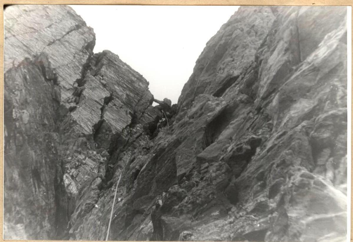 Photo of Peak E. Korzhenevskoi from the Big Pamir Plateau.
Assault exits of three participants
 Passing the key section R5–R1.
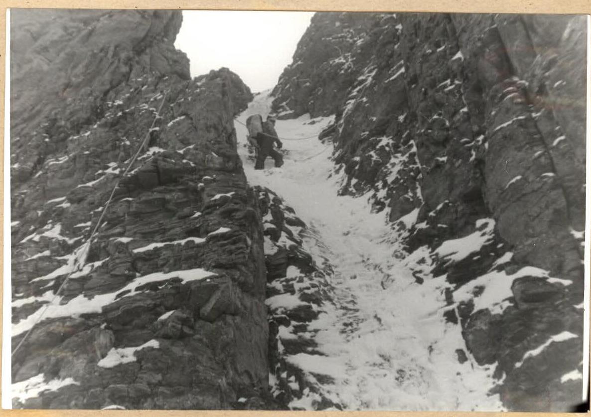
 Section R9–R10. Participant before entering the chute-chimney.
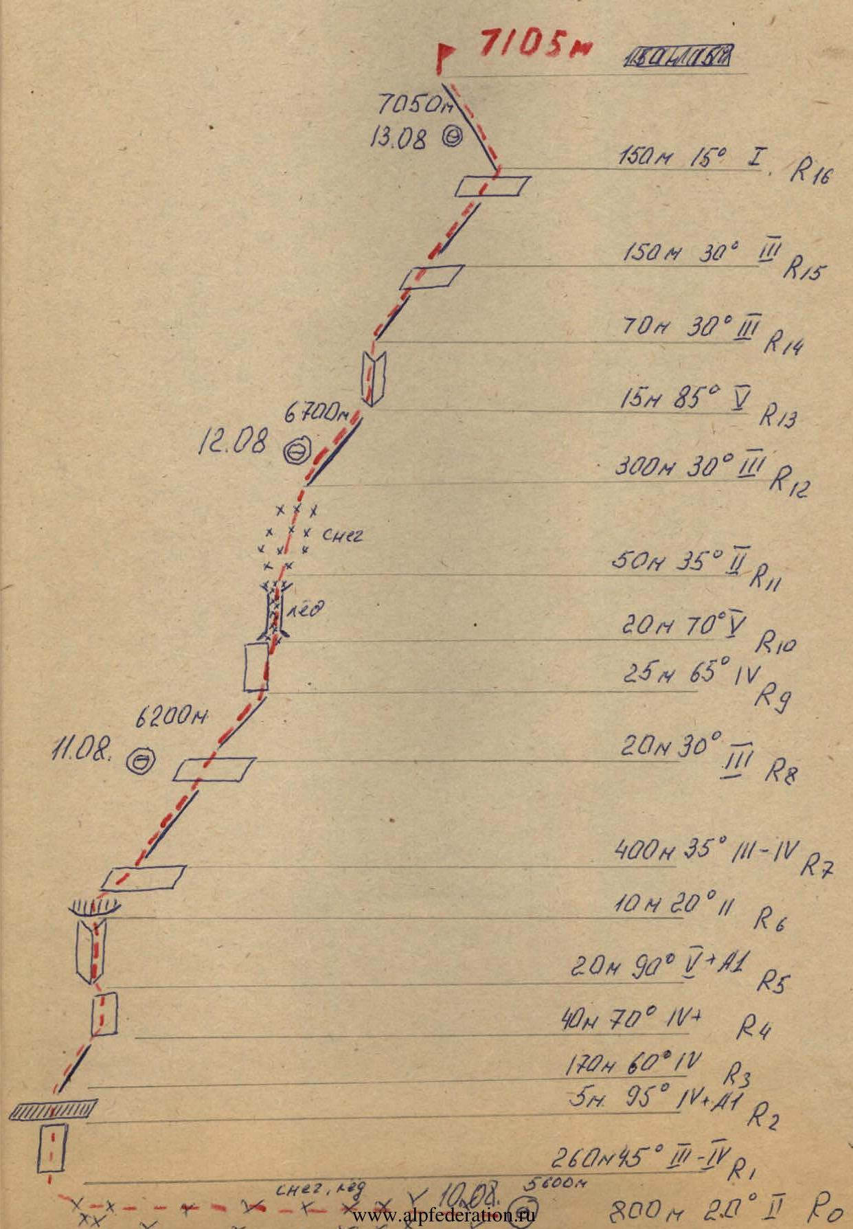
Table of Main Characteristics of the Climbing Route

| Date | Designation (R) | Average steepness in | Length in m | Terrain characteristics | Difficulty | Condition | Weather conditions | Rock pitons | Ice pitons | Bolts |
|---|---|---|---|---|---|---|---|---|---|---|
| 10.08.1984 | R0–R1 | 20° | 800 | snow slope | 2 | snowy | good | – | – | – |
| R1–R2 | 45° | 260 | ice slope | 2– | snow-covered | good | – | 5 | – | |
| R2–R3 | 95° | 5 | ice bergschrund | 5 | icy | good | – | 3 | – | |
| R3–R4 | 60° | 170 | overhanging ridge | 4 | icy | good | 3 | – | – | |
| R4–R5 | 70° | 40 | wall | 4 | –"– | satisfactory | 5 | – | – | |
| R5–R6 | 90° | 20+ | inner corner | 5 | –"– | satisfactory | 6 | – | – | |
| R6–R7 | 20° | 10 | ledge | 2 | snowy | satisfactory | – | – | – | |
| R7–R8 | 30–40° | 400 | ridge, ledges | 3–4 | –"– | satisfactory | – | – | – |
Departure time — 9:00. Stop for bivouac — 18:30. Climbing hours — 7 hours 30 minutes. Bivouac conditions — good.
| 11.08.1984 | R9–R10 | 60° | 25 | wall | 4 | icy | good | 3 | – | – |
|---|---|---|---|---|---|---|---|---|---|---|
| R10–R11 | 70° | 20 | chute, rocks | 4 | –"– | satisfactory | 1 | 2 | – | |
| R11–R12 | 35° | 50 | snow slope | 2 | snowy | satisfactory | – | – | – |
Departure time — 9:00. Stop for bivouac — 18:00. Climbing hours — 7 hours. Bivouac conditions — good.
| 12.08.1984 | R12–R13 | 30° | 300 | ridge | 3 | snowy | good | – | – | – |
|---|---|---|---|---|---|---|---|---|---|---|
| R13–R14 | 85 | 15 | inner corner | 5 | icy | good | 4 | – | – | |
| R14–R15 | 30 | 70 | ridge, ledges | 3 | –"– | satisfactory | – | – | – | |
| R15–R16 | 45 | 150 | ridge, ledges | 3 | snowy | satisfactory | – | – | – |
Departure time — 9:00. Stop for bivouac — 18:00. Climbing hours — 7 hours. Bivouac conditions — good.
| R16–R17 | 15 | 450 | ridge | 1–2 | snowy | bad | – | – | – | |
|---|---|---|---|---|---|---|---|---|---|---|
| R17 | – | – | – | – | – | – | – | – | – |
Descent from the summit. Departure time — 9:00. Summit arrival — 10:00. Climbing hours — 1 hour.
Total: 22 hours 10 minutes
Explanation for the Table
R1–R2 — Ice slope. Overcome using front points of crampons with piton belay.
R2–R3 — Overhanging upper edge of the bergschrund, passed using artificial climbing techniques (ACT). The rest followed using a fixed rope.
R3–R4 — Destroyed snowy rocky ridge. Passed simultaneously.
R4–R5 — Wall, heavily destroyed. Passed with piton belay for the first climber, the rest followed using a fixed rope. Weather started to deteriorate: fog, snow, wind.
R5–R6 — Inner corner with overhangs. Passed with piton belay, using ACT. Other participants followed using a fixed rope.
R6–R7 — Ledge, simultaneous movement.
R7–R8 — Ridge heavily destroyed. Passed with alternate belay. Bivouac on an inclined ledge at the end of the section.
R8–R9 — Destroyed ridge. Simultaneous movement.
R9–R10 — Wall leading to an ice chute, chimney. Passed with piton belay. Autonomous rope teams.
R10–R11 — Chute-chimney, with icy rocks. At the top, it turns into a chimney. Passed with piton belay for the first climber. The rest followed using a fixed rope.
R11–R12 — Snow-ice slope. Simultaneous movement on the slope. Convenient bivouac.
R12–R13 — Heavily destroyed ridge. Alternating ledges and walls. Mostly alternate movement.
R13–R14 — Inner corner. Rocks snowy and icy. Piton belay for the first climber. The rest followed using a fixed rope.
R14–R15 — Ridge leading to a ledge. Alternate movement, partly simultaneous.
R15–R16 — Ridge, rock destruction, series of ledges and walls leading to the third ascent. Bad weather: wind, snow, fog. Visibility 20–30 m. Stopped for bivouac.
R16–R17 — Simple ridge leading to the summit. Met with an auxiliary group on the summit. Descent via Tseitlin's route.
Tactical Plan for the Ascent
to Peak E. Korzhenevskoi via the South Ridge from Moskvin Glacier, 5B category.
1. Climbing Objective
Participation in the Central Council of the "Zenit" Sports Society Alpine Championship in the high-altitude category.
2. Organization of the Ascent
Following a training cycle and ascents to Mt. Elbrus and Peak Four (6400 m), the team was formed consisting of: Korenyugin (team captain), Kamzolov — Aksenov; Perelygin — Kuzenkov (by rope teams). The rope teams have experience on routes of 5B and 5A category, respectively. All team members (except Kuzenkov) have experience climbing seven-thousanders (Peak Lenin, Peak Kommunizma).
The team planned to ascend without prior load carrying or route preparation due to the following reason: all team members completed a training ascent to Peak Four (6400 m). Kuzenkov participated in load carrying to Peak Korzhenevskoi via Tseitlin's route up to 6400 m. Thus, all participants had sufficient acclimatization. Before starting the route, the team had a three-day rest.
Tactical Actions of the Team
The Dagestan Republican Rescue Service team was formed in 1989, participating in high-altitude ascents during the 1989–1991 and 1993–1996 seasons. Before the 1999 season, the team conducted a cycle of general physical training and tactical preparation. However, the final agreement to participate in the "Alp-Navruz" firm's work on the Moskvina meadow was reached only on July 10, 1999, with the senior coach Sychev V. P. (Kursk). The group flew to Dushanbe on August 21, and to the Moskvina meadow (4200 m) on August 23. Between August 27 and September 4, they completed two acclimatization climbs to heights of 5800 m and 6100 m, with overnight stays at 5100 and 5800 m. They worked on fixing ropes at these heights. Five ropes were fixed on the icefall between 5100–5300 m, to the right of the rocks and waterfall (later, on all exits, ice screws were re-driven as they were melting intensively). Additionally, ropes were fixed from the "Sail" rock on the traverse to the 6100 m col (about 300 m). New anchor points were created, and old ones were reinforced. A total of 1420 m of fixed ropes were installed for the ascent and descent of guiding groups and clients to ensure safety.
The group left the base camp on August 8, 1999, at 13:00, with a slight gap, and reached the 5100 m site by 17:00. A tent and some equipment were already in place.
On August 9, 1999, the group planned to reach 5800 m, to a niche, and bivouac there. However, Turkish climbers that day ascended to the summit from 6100 m, and the group received instructions to ascend to 6300 m and support the Turkish climbers.
The group left the 5100 camp at 7:00 and reached the start of the route by 10:00. They ascended the ice slope (fixed ropes) in one and a half hours and had tea and a snack below at 5800 m. They traversed in good time.
At the 6100 m site, they met two Turkish climbers. They learned that the Turks had turned back from 6700 m, and two of their companions had continued towards the summit. By 14:00, both groups reached the 6300 m site, where a "Kangchenjunga" tent had already been set up by Mironov's group (Novosibirsk).
By 16:00, the Turkish climbers descended, and 50 m of fixed ropes were installed for them from 6300 m down (a challenging section).
On August 10, 1999, at 9:00, the group departed from the 6300 m camp. The weather, which had been good, worsened overnight: it became cold, with strong winds, blowing snow, and clouds. The group carried a rope (Edelrid, 9 mm, 40 m), a snow anchor, and 6 ice screws but did not rope together. Through numerous ascents and undulations on the ridge, and via fixed ropes at 6800–6900 m, the group reached the summit at 14:00, stayed for 15 minutes, and took photos. Visibility was zero, with wind and light snow. They began their descent, staying in sight of each other, and returned to the 6300 m camp by 17:00.
The next day, August 11, the group remained in the 6300 m camp. A German group (Dav-summit) had planned to ascend that day but did not due to worsening weather. On August 12, in heavy snowfall, the group departed the camp at 9:00 and descended to the base camp by 16:00.
During the work at "Alp-Navruz" base camp and the high-altitude climbs, the team worked together with the Chairman of the Dagestan Alpine Federation, Leonov P. G. They all started the ascent together, but Leonov P. G. was forced to turn back from 6600 m due to illness (severe stomach pain). Everyone returned to the base camp together.
UIAA Route Diagram
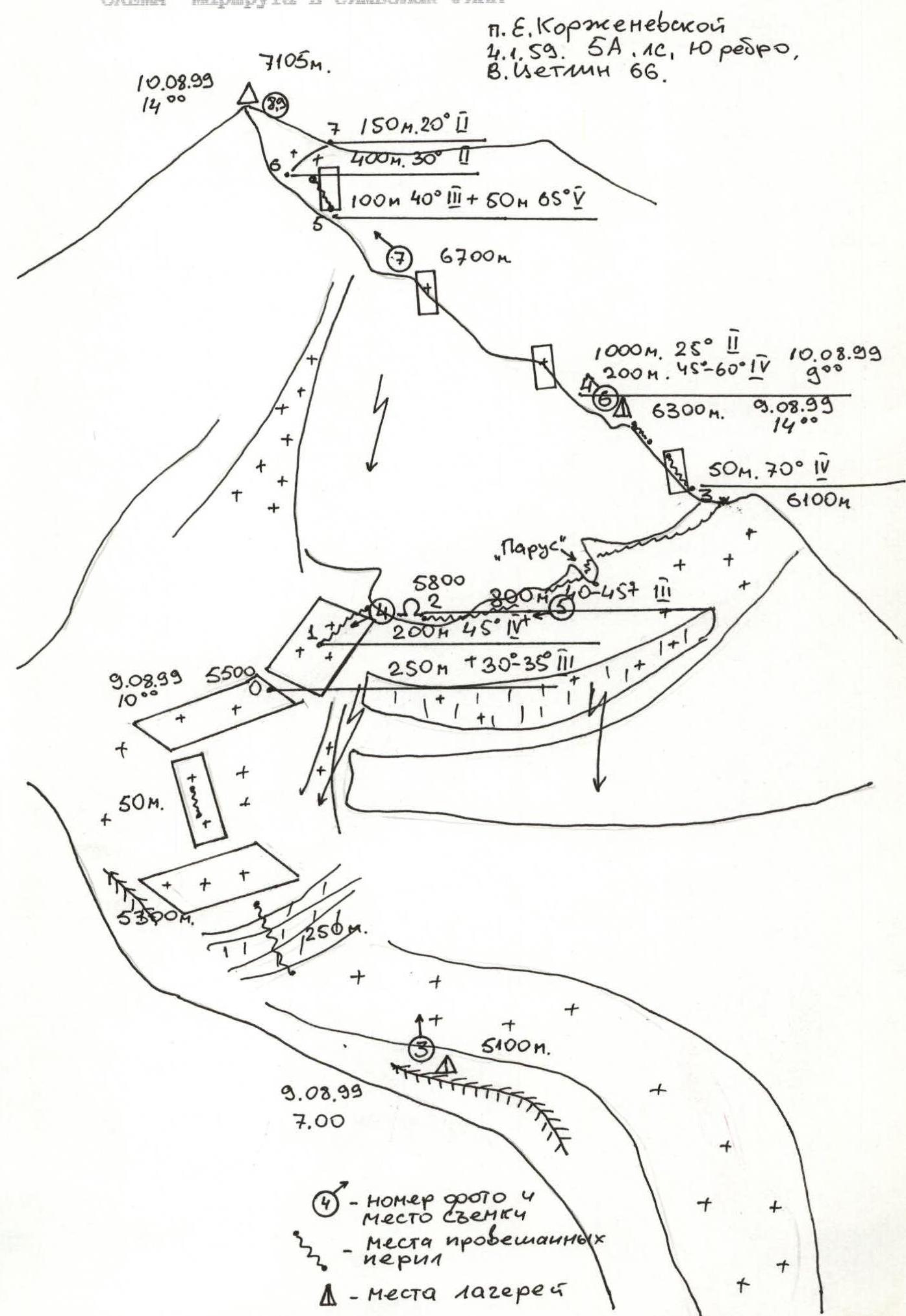 UIAA Route Diagram for Peak E. Korzhenevskoi, 4.1.59, 5A category, South Edge, V. Tseitlin '66.
Route Description
From the start of the route, on the firn field (5500 m) below the West wall of Peak E. Korzhenevskoi, move directly upwards under the wall, left of the fractures and drop-offs (section R0–R2). The steepness increases sharply ( местами up to 50°), fixed ropes are installed, and it is possible to move without belay, depending on the slope condition. Below the wall is a niche, a convenient spot for a camp (5800 m). Then, traverse right along the wall with a slight gain in height, partly steep on the traverse, which may require belay depending on the condition. The fixed ropes run from point to point on the rocks. The largest fixed rope section is 120–130 m from the "Sail" rock. Further along the wall, left upwards into a couloir and onto the 6100 m col. A bivouac is possible. Then, left under the ascent of the South Ridge (section R3–R4). On the rocks, there is an old rope; be cautious. The rocks are straightforward, crampons are desirable. Then, a snowy-icy ridge begins (rocks are only encountered before the summit). After another 150–200 m, there is a "pocket" on the ridge, a shoulder. A convenient spot for a camp (6300 m). Further onto the ridge up to 6800–6900 m, move along the ridge, sometimes deviating left onto icy walls, sometimes steep up to 60°.
There are several descent options. Caution! Do not get close to the ridge edge; there are cornices to the right! At 6800 m, there is a final icy ascent-serac. Beyond it is a rocky ascent; pass it at the junction with the ice (section R5–R6). Then, follow the icy undulations and drifts under the summit tower (height about 7000 m). Traverse it right along a drift, gaining height onto an unclear col in the East Ridge, turn left, and follow a simple ridge, left of the cornice, along the rock face, to the summit. Here, on the rocks, is a cairn. In bad weather, its location can be challenging. Descent follows the ascent route.
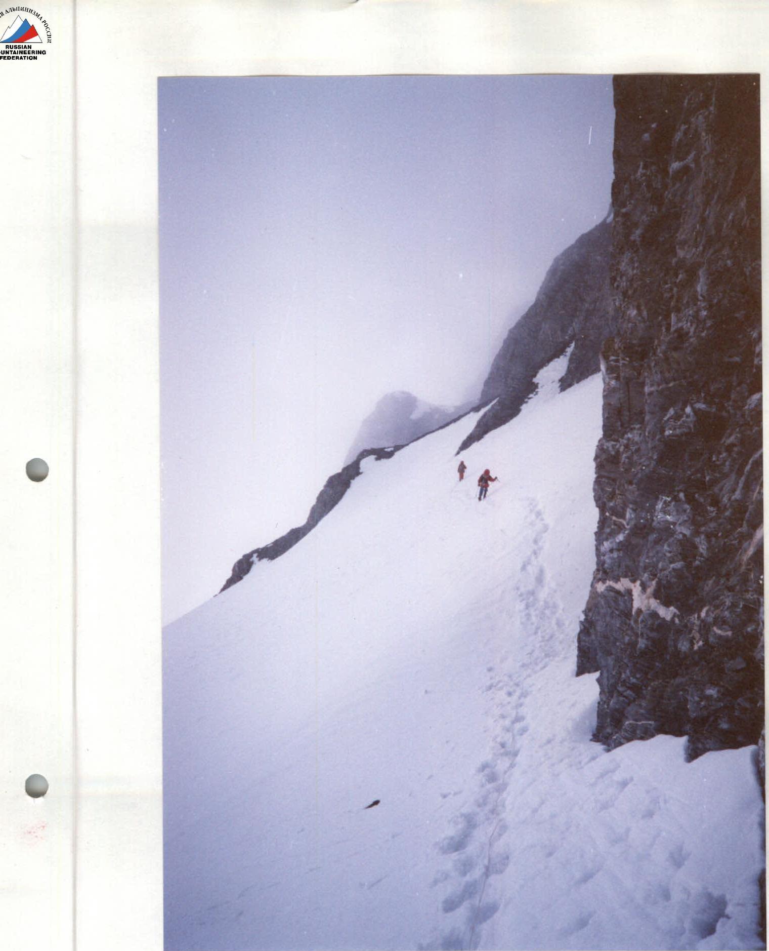 Photo 5. Traverse under the West wall of E. Korzhenevskoi. Fixed rope descent. Section R2–R3. 6000 m, August 12, 1999, 10:00. Smena-Symbol.
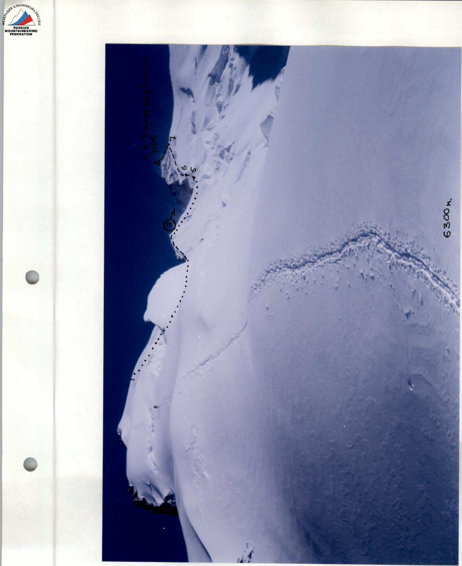 Photo 6. South Ridge and summit of Peak E. Korzhenevskoi from the 6300 m camp. Section R4–R8. August 10, 1999, 9:30. Smena-8m.
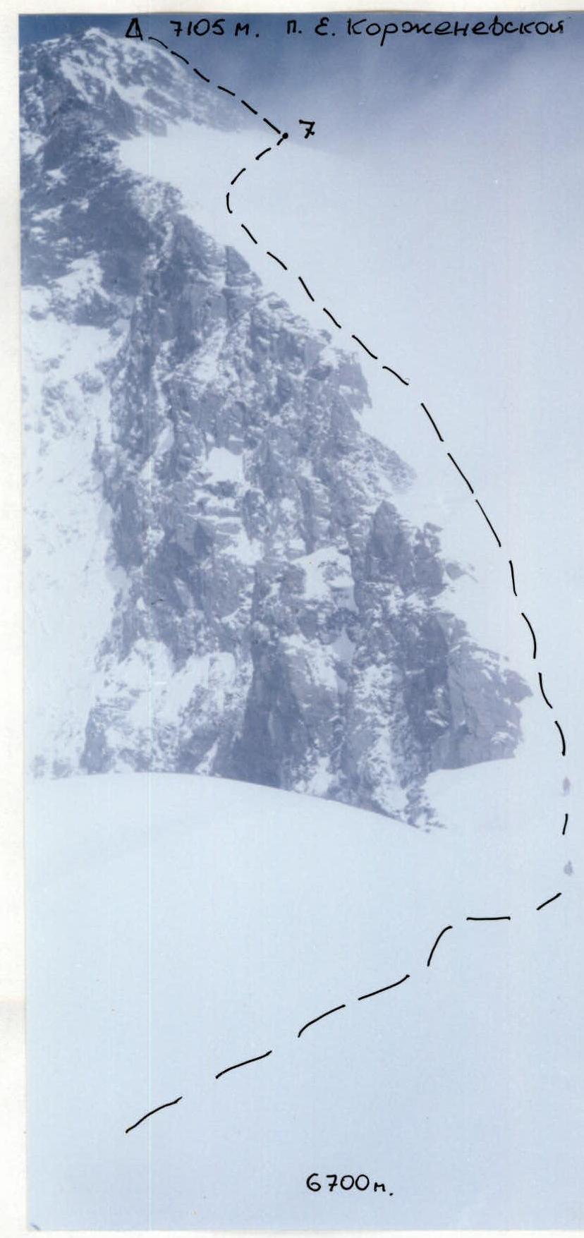 Photo 7. South Ridge and summit of Peak E. Korzhenevskoi from 6700 m. Section R4–R8. August 10, 1999, 12:00. Smena-8m.