Report
On ascending the peak of Ismoila Somoni (formerly Peak Kommunizma) via the southern slope from Walter Glacier, BPP, and "Big Barrier" ("Classics") - ice-snow route, category 5A difficulty, by the "Bars" team from August 11, 2022, to August 20, 2022.
I. Ascent Report
| 1. General Information | ||
|---|---|---|
| 1.1 | Full name, sports rank of the team leader | Dusheyko Alexander Sergeyevich, 1st sports rank |
| 1.2 | Full name, sports rank of participants | Belyankina Natalia Pavlovna, 1st sports rank (at the time of the ascent, it was pending but not registered) |
| 1.3 | Full name of the coach | Torshin Mikhail Viktorovich, 1st sports rank |
| 1.4 | Organization | VRPO "Sports Alpine Federation" |
| 2. Characteristics of the Ascent Object | ||
| 2.1 | Region | Academy of Sciences Range (western side of Fedchenko Glacier from Yazgulemsky Pass in the south to Muksu River in the north with all lateral spurs) |
| 2.2 | Valley | Moskvina Plain (Walter Glacier) |
| 2.3 | Section number according to the 2013 classification table | 42 |
| 2.4 | Name and height of the peak | Peak Kommunizma (Ismoila Somoni Peak) – 7495 m |
| 2.5 | Geographical coordinates of the peak (latitude/longitude), GPS coordinates | - |
| 3. Route Characteristics | ||
| 3.1 | Route name | Southern slope from Walter Glacier, BPP, and "Big Barrier" ("Classics") |
| 3.2 | Proposed difficulty category | 5A |
| 3.3 | Degree of route exploration | - |
| 3.4 | Route terrain characteristics | ice-snow |
| 3.5 | Height difference of the route (data from altimeter or GPS) | 3135 |
| 3.6 | Route length (in meters) | 12750 m on the map (16430 m by navigator) |
| 3.7 | Technical elements of the route (total length of sections with varying difficulty, specifying terrain characteristics: ice-snow, rock) | II category rock – 450 m, IV category ice – 300 m, V category ice – 150 m, VI category – 0 m |
| 3.8 | Average slope of the route, (°) | 24° |
| 3.9 | Average slope of the main part of the route, (°) | 35° |
| 3.10 | Descent from the peak | Via 30 category 5A by the ascent route |
| 3.11 | Additional route characteristics | Water (snow) available. |
| 4. Team Action Characteristics | ||
| 4.1 | Time in motion (team's walking hours, indicated in hours and days) | 60 h (36 ascent, 24 descent), 9 days. |
| 4.2 | Camps | Site |
| 4.3 | Time spent processing the route | - |
| 4.4 | Entry onto the route | 3:30 on August 11, 2022 |
| 4.5 | Reaching the peak | 18:37 on August 17, 2022 |
| 4.6 | Return to the base camp | 18:45 on August 20, 2022 |
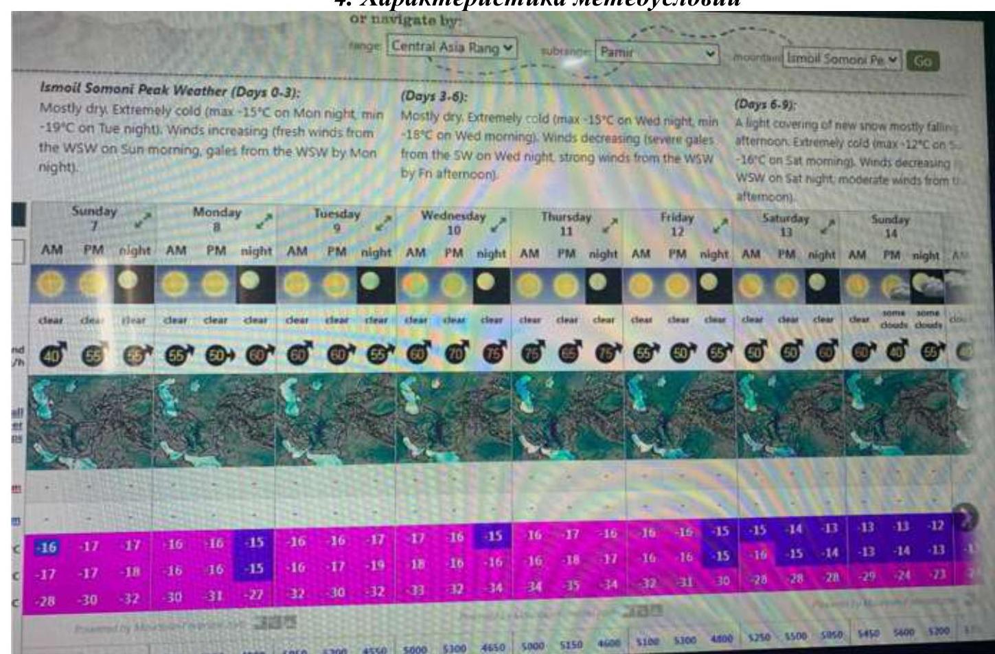
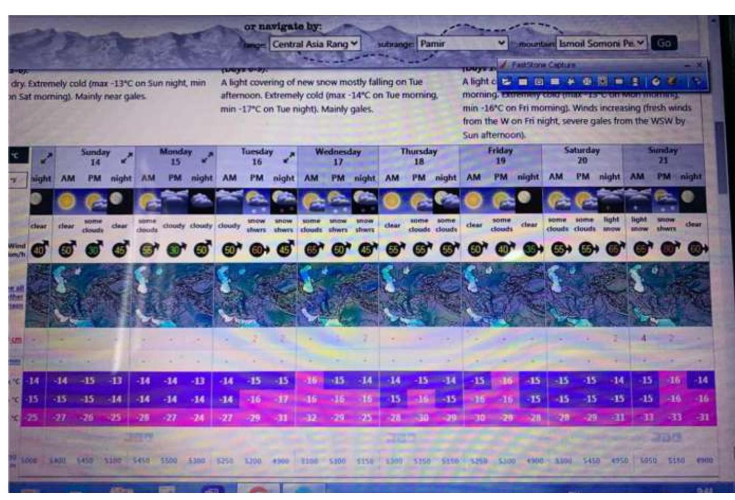
| 5. Weather Conditions | ||
| 5.1 | Temperature, °C | –7–32°C |
| 5.2 | Wind speed, m/s | 9–17 m/s |
| 5.3 | Precipitation | About 30 cm of snow |
| 5.4 | Visibility, m | variable |
| 6. Responsible for the Report | ||
| 6.1 | Full name, e-mail | Dusheyko Alexander Sergeyevich info@alp-school.com |
II. Ascent Description
1. Object Characteristics
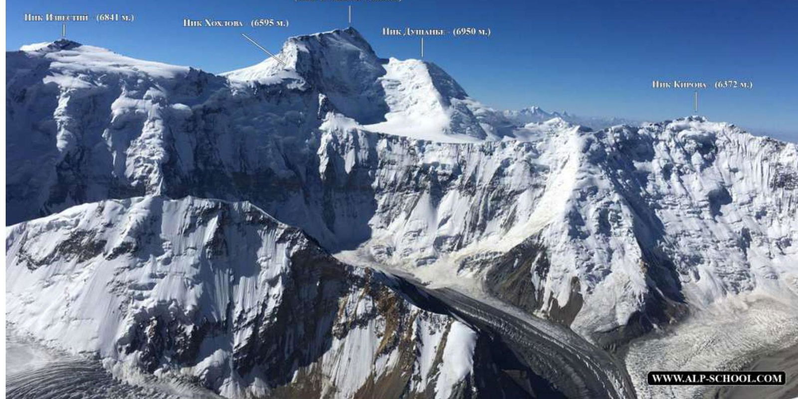
General View of the Peak
Photo taken: August 19, 2018, from the slope of Korzhenevskaya Peak at an altitude of 6500 m.
Panorama of the Area

Peak Kommunizma (7495 m) (Ismoila Somoni Peak)
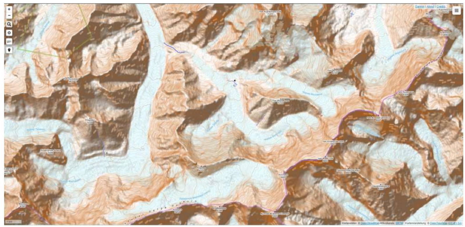
Map of the geographical location of the area. We travel by car to the Lakhsh area, Dzhirgatal airfield. From there, by helicopter, 40 minutes to Moskvina Plain (intersection of Moskvina and Walter Glaciers).
2. Route Characteristics
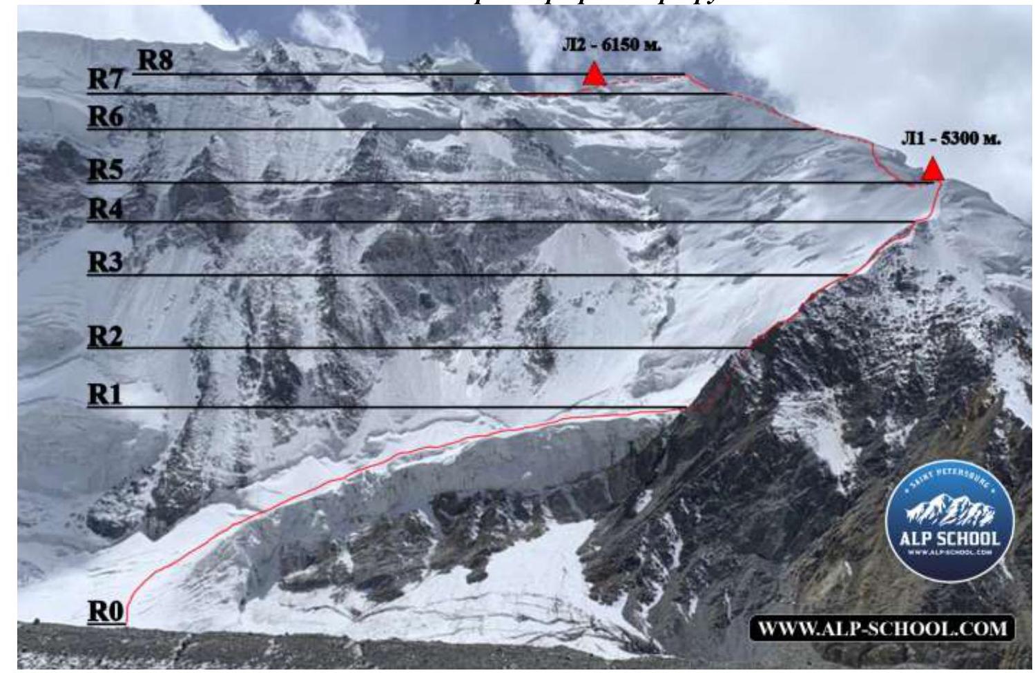
Technical photograph of the route R0–R8
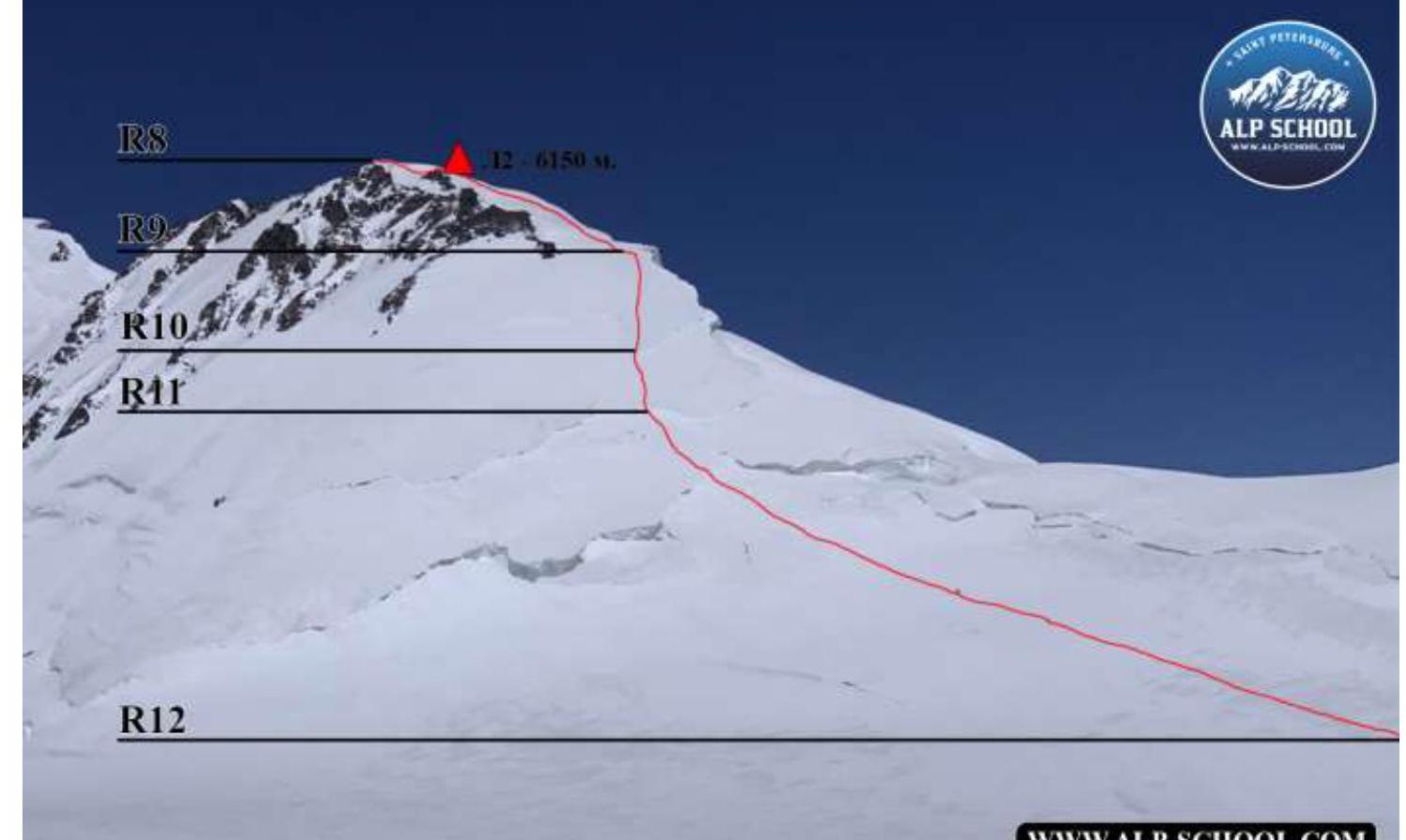
Technical photograph of the route R8–R12
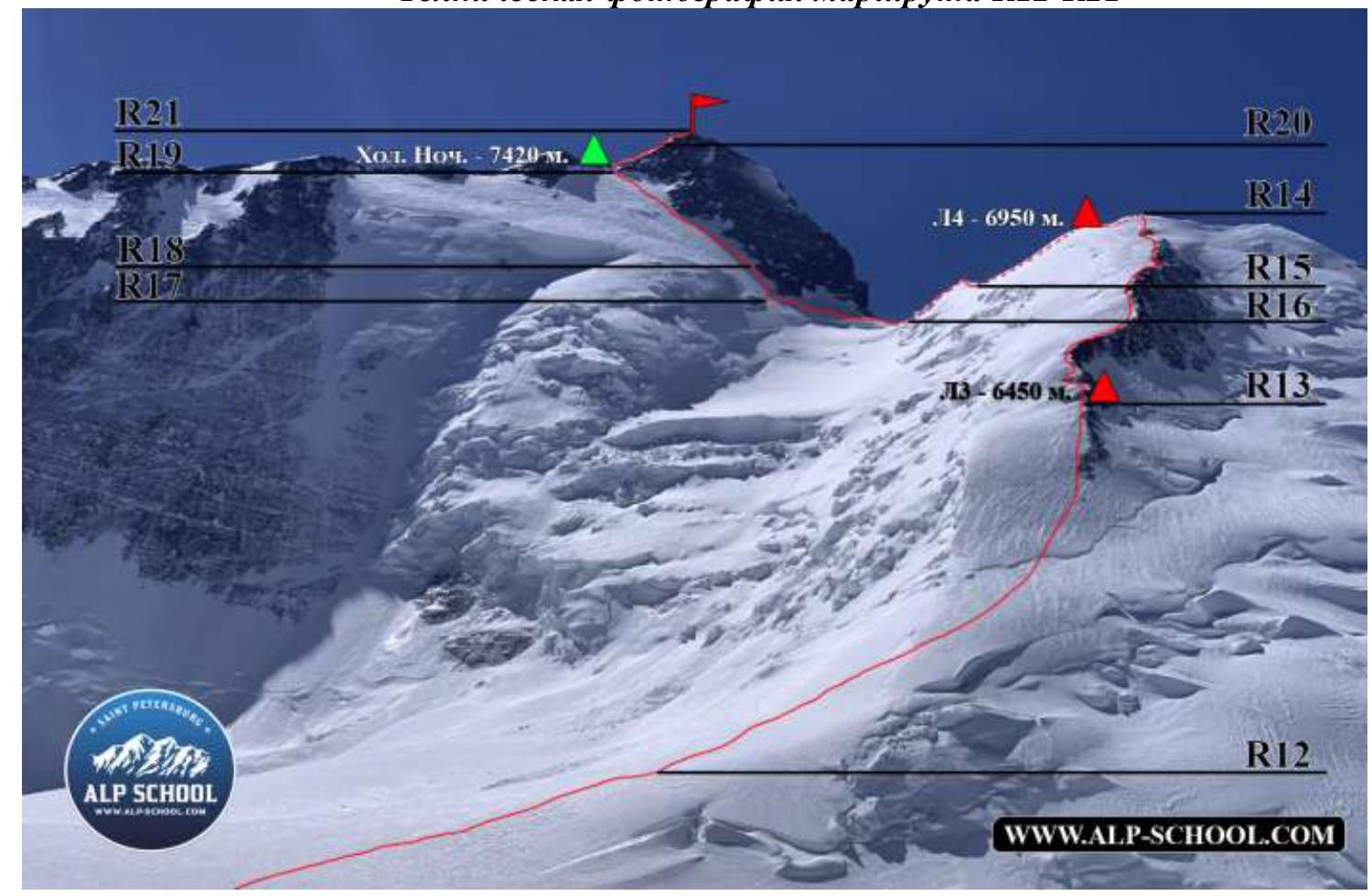
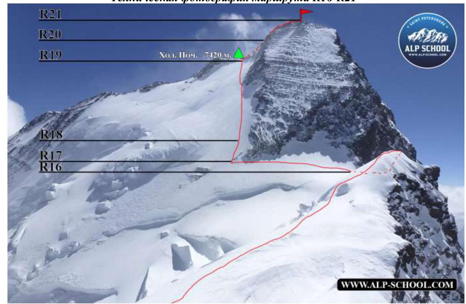
Technical photograph of the route R16–R21
3. Team Action Characteristics
| Section # | Description | Photo Number |
|---|---|---|
| R20–R21 | We ascend with alternating movement up the snowy wall and reach a sharp ridge with a 35° slope; before the peak, there's a slight flattening and the ridge widens to several meters. | Photo #17 |
| R19–R20 | Along the right couloir, 30 m, 50°. We ascend to the ridge. At the end of the couloir, there's a small rock section with a convenient ledge for camping at 7430 m, fenced on both sides by the terrain. On the ridge, there are rocks on the right side. On the left, there's a sharp snowy overhang, sometimes with small cornices. We proceed along the left side, maintaining distance from the edge, and approach a snowy wall about 10 m high, 70° (with an old rope frozen under the snow). | |
| R18–R19 | Movement upwards along the "spade" – a snowy slope. To the left of the rocks almost to the top. The slope is 35°, with some crevices and hard firn. At the end, the steepness increases to 45°. We'll encounter two couloirs leading to the ridge. | Photo #16 |
| R17–R18 | Straight up, to the left of rock outcrops. 70 m. 45°. | Photo #16 |
| R16–R17 | From the saddle between "Verblud" and Kommunizma, after crossing a small bergschrund, we start traversing left with a slight gain in height towards the "spade". At the end, the terrain steepness reaches 50°. We continue traversing: pass the first couloir, reach a long rock outcrop, and can set up a station at its base using a loop (there's old and new gear on this section). | Photos #15 and #16 |
| R15–R16 | "Verblud" can be traversed in two ways. Previously, it was traversed on the left along a steep slope, but due to changes in the snow-ice relief, this became long and unsafe. The second way: movement along the ridge with a slight gain. We stuck to the right side, avoiding small cornices on the left. After passing "Verblud", we descend to the saddle between Verblud and Kommunizma along the left slope of Verblud – 40°, about 70 m. | Photos #13 and 14 |
| R14–R15 | To the left, we traverse the peak towards Kommunizma Peak along the eastern ridge of Dushanbe Peak, not on the very edge but on the left side. After 50 m, we start descending onto a wide ridge, at the foot of which lies a bergschrund about 2 m high. There's ample space for tents. A bit higher is a traditional site for a storm camp. Descending from the ridge occurs along a steep snowy slope; it's recommended to move in pairs and alternately on the left side. If you go straight, you'll encounter icy drops with a difference of about 30 m. We descend onto a wide saddle and approach "Verblud". | Photo #12 |
| R13–R14 | Simultaneous movement in a group, along the rocks, sticking to the left side, to ascend Dushanbe Peak. At the very end, there's a rocky outcrop to be bypassed on the left, and then straight up to the peak. It's better not to step on the very top (3-4 m depending on the season due to overhanging snow). | |
| R12–R13 | From the left side of BPP, we begin to approach the northern ridge of Dushanbe Peak along a snowy slope, cross a bergschrund, and reach a firn slope with a steepness of about 40°. We move under the rocky ridge, sticking to the left, at a height of 6450 m. The first convenient sites for several tents appear. (If there's time and energy, it's better to ascend higher, to ~6500 meters, where there's a good site for many tents) | |
| R11–R12 | A gentle snowy slope transitioning into BPP, with a passage under Dushanbe Peak, about 2000 meters. | |
| R10–R11 | A steep firn slope, 35° – ends with a small bergschrund (recommended to move simultaneously with intermediate belays). | |
| R9–R10 | Descent along a firn slope (partly ice) to a bergschrund about | |
| 1.5 m high; 10 m before the bergschrund, the slope steepness increases to 45° (recommended to move alternately with belays on ice axes or Abalakov loops). | ||
| R8–R9 | After 50 m, downhill, there's a good site, fenced on three sides by the slope, for a large camp at 6150 m (if there's time and energy, it's better to descend to Big Pamir Plateau and set up camp at 5860 m or at the foot of Dushanbe Peak). We descend along a snowy wide ridge with a steepness of about 20° on the right-hand side when looking down. | Photo #11 |
| R7–R8 | The bergschrund can be crossed head-on – 50°, about 30 m with a traverse to the right, about 20 m, or initially bypassed on the right between seracs along a slope of about 35°. We reach a positive slope and, sticking to the left, ascend to the snowy ridge of the right peak of "Grudi" (6160 m). We traverse the peak, sticking to the left of the ridge, and turn left onto a wide eastern ridge. | Photos #9 and 10 |
| R6–R7 | Movement along a snowy slope about 100 m under the bergschrund. Straight up, 35 m, 45°. The slope is under a serac, bypassed on the right, about 15 m, with a slope of 30°. After 250 m, we approach another bergschrund. | Photo #8 |
| R5–R6 | Simultaneous movement along a firn slope with a steepness of about 30°. There's a bergschrund on the section, bypassed alternately with belays on ice axes. On the right side, there's an ice wall about 2 m high, with an exit onto a snowy slope – 30°. 400 m along the snowy slope, we approach a camp at 5800 m and the start of section R6. | Photos #6 and 7 |
| R4–R5 | We move in crampons about 200 m along a firn slope, 35°. We reach a large shoulder where a large camp can be set up at 5300 m (if well acclimatized and time allows, it's better to ascend higher to 5800 m). | Photo #4 |
| R3–R4 | After reaching the ridge, we stick to the left side for about 250 m. We approach a small spur on the left. Along it, we return to the ridge and climb onto a snowy slope. | Photo #4 |
| R2–R3 | Straight along the ridge, mostly on the left side. There's a small grotto with an exit onto a rock slab about 70°, 3 meters, transitioning into an internal corner about 90°, 2.5 meters, category 3 rocks. | Photo #3 |
| R1–R2 | Approaching the talus couloir, we remove crampons and start moving onto the ridge. About 70 m – 35°. There are old fixed ropes in some places. | Photos #1 and 2 |
| R0–R1 | We approach section R0 by traversing the open glacier with small crevices. Then, moving simultaneously in a group with crampons along a slope of 30-35°, we reach a snow-ice cushion with closed and deep crevices. For safety, it's better to move before sunrise and stick to the right side of the cushion. The end of the cushion is most dangerous – constantly snowing and prone to avalanches. | Photo #1 |
Photo #1
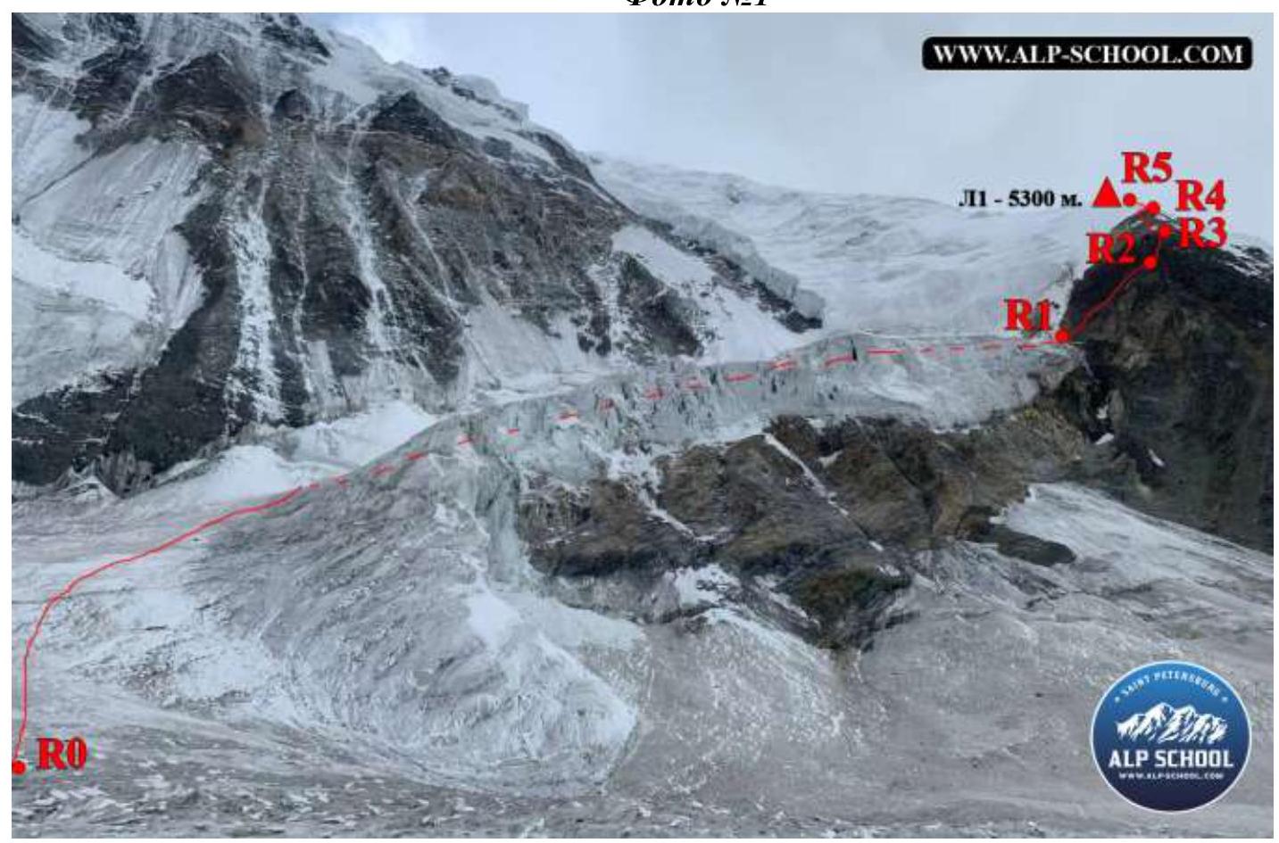
Photo #2
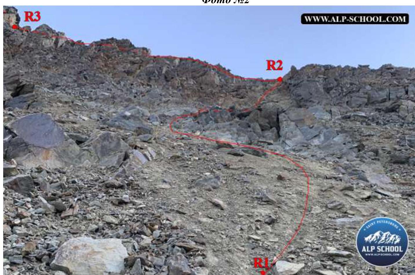
Photo #3
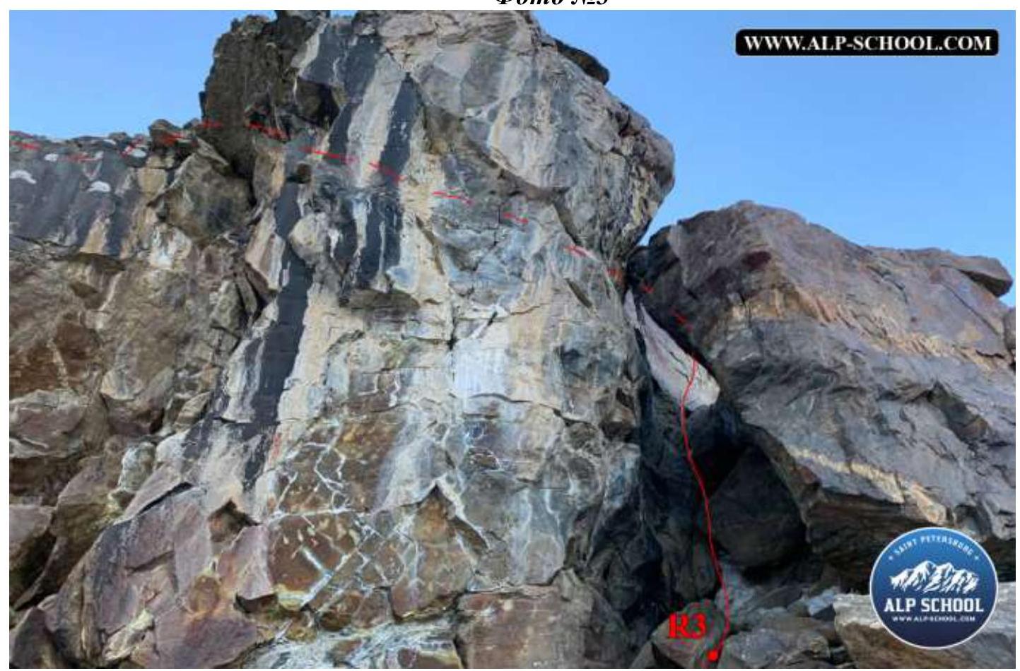
Photo #4
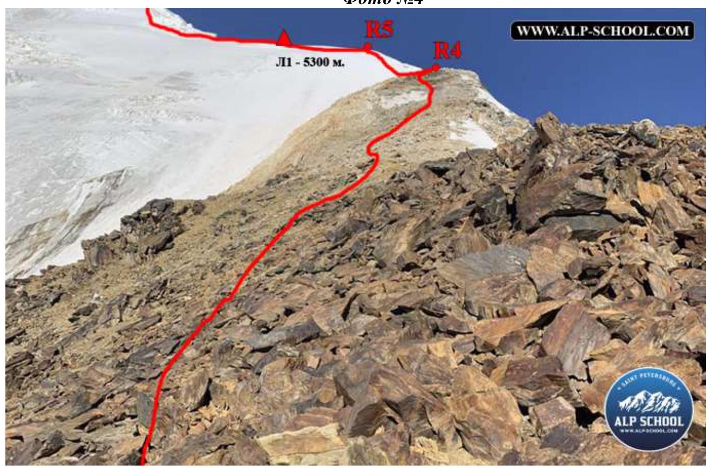
Photo #5
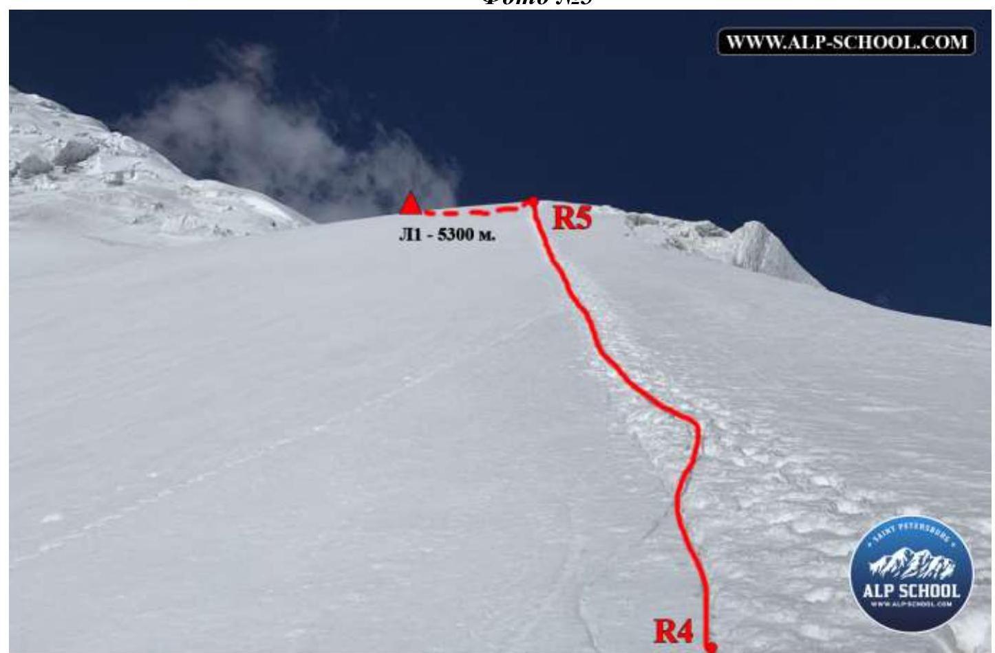
Photo #6
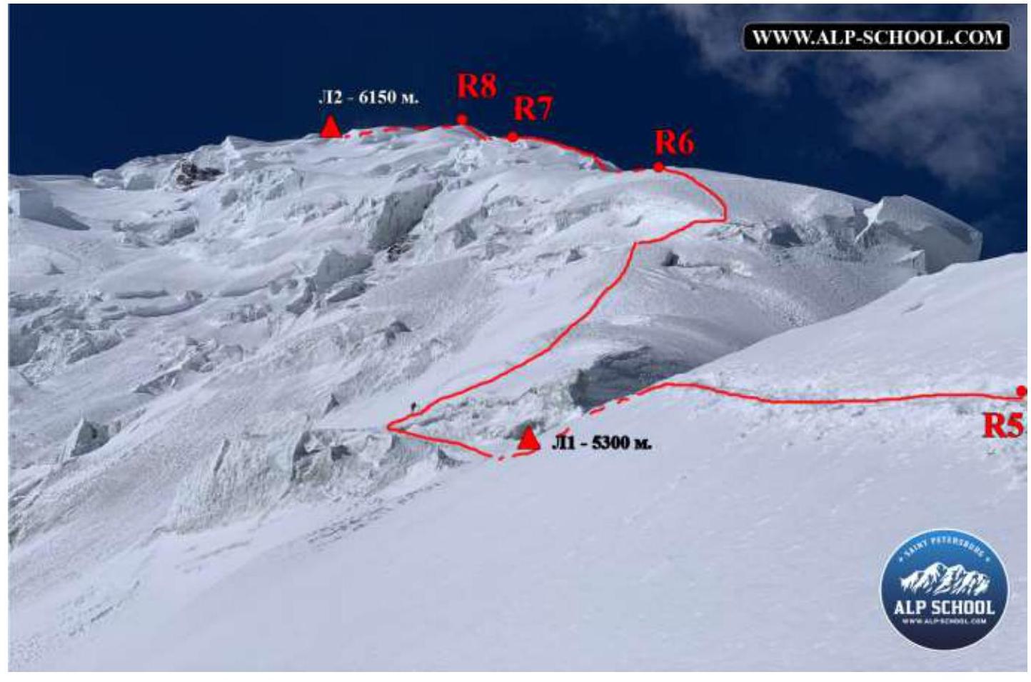
Photo #7
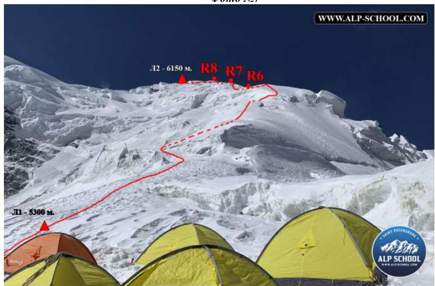
Photo #8
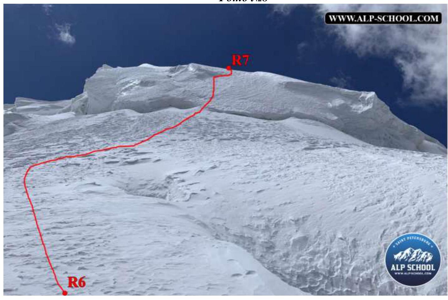
Photo #9
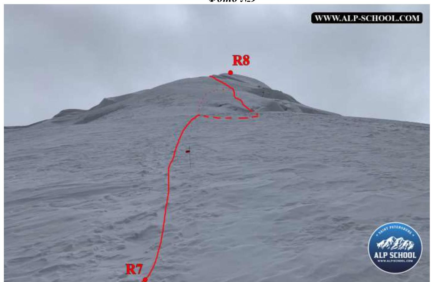
Photo #10
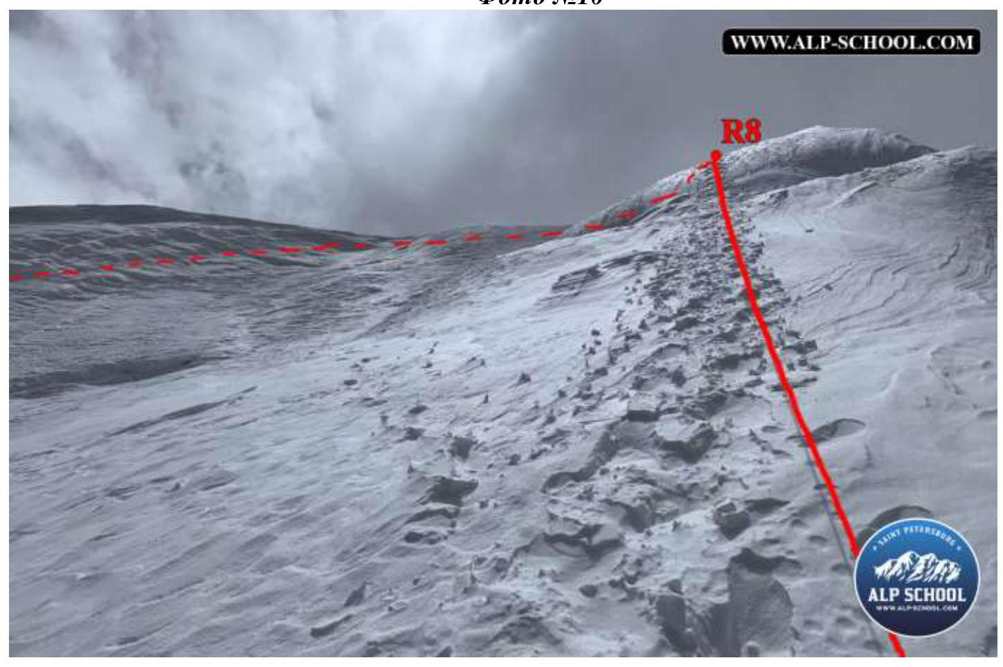
Photo #11
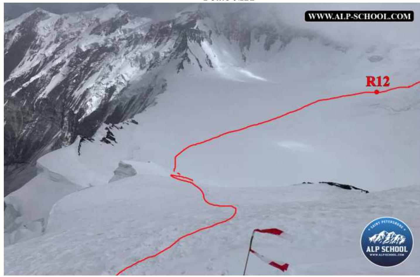
Photo #12
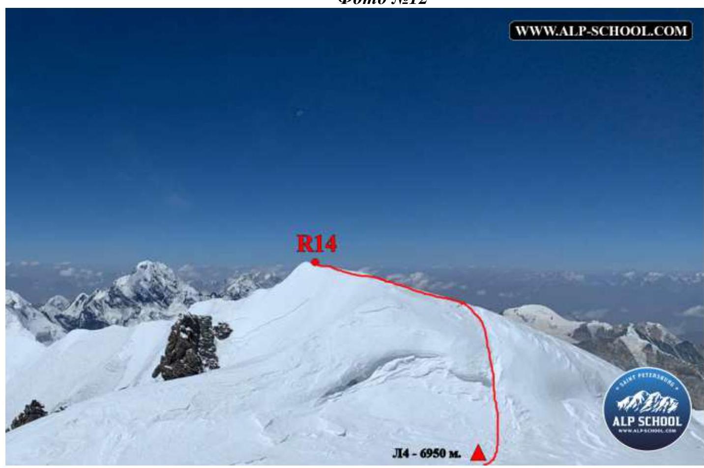
Photo #13
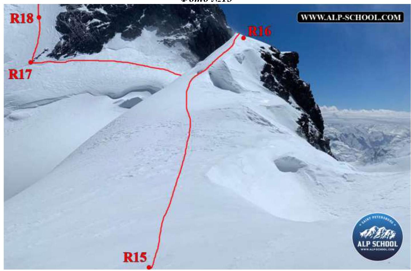
Photo #14
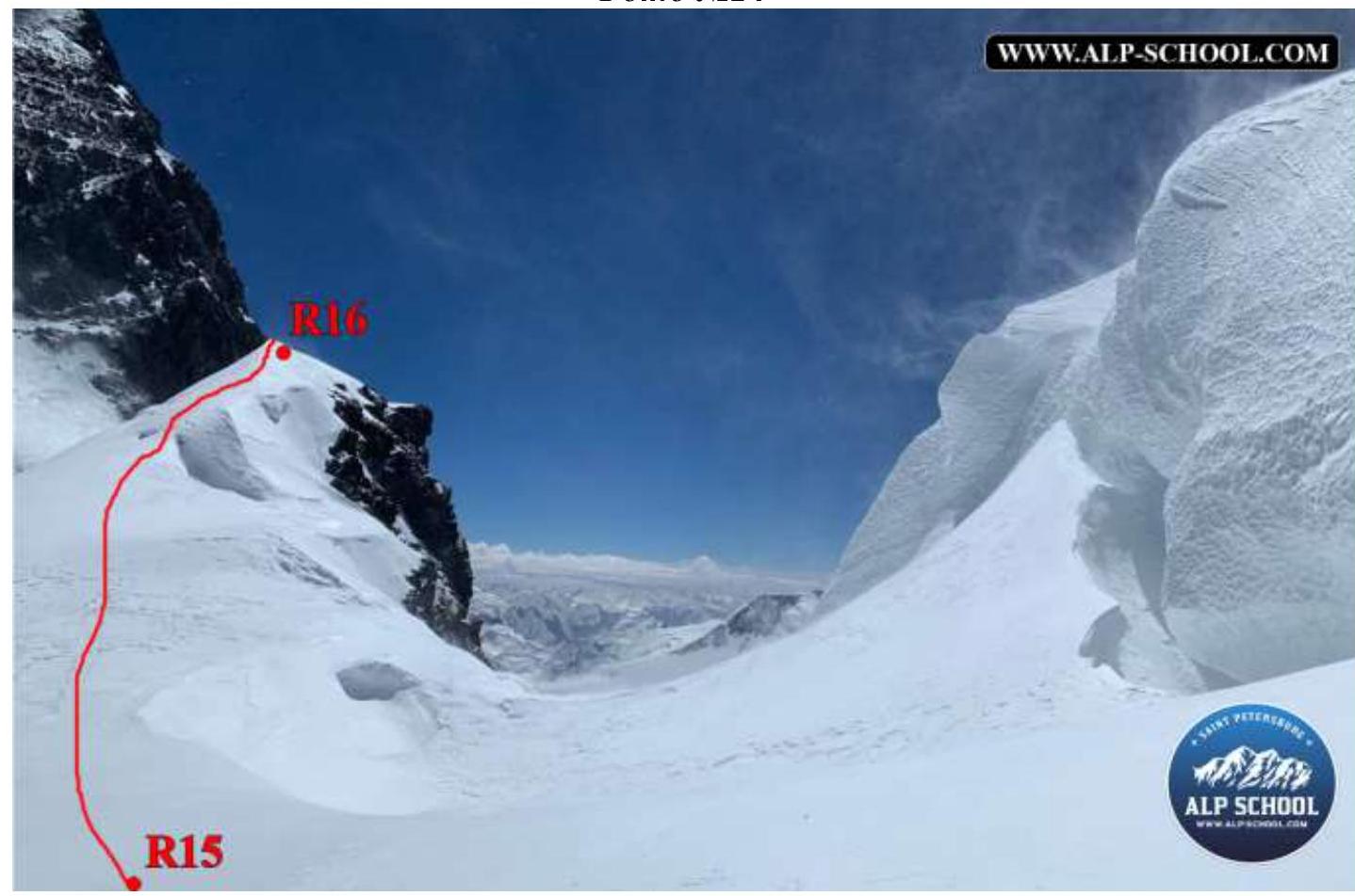
Photo #15
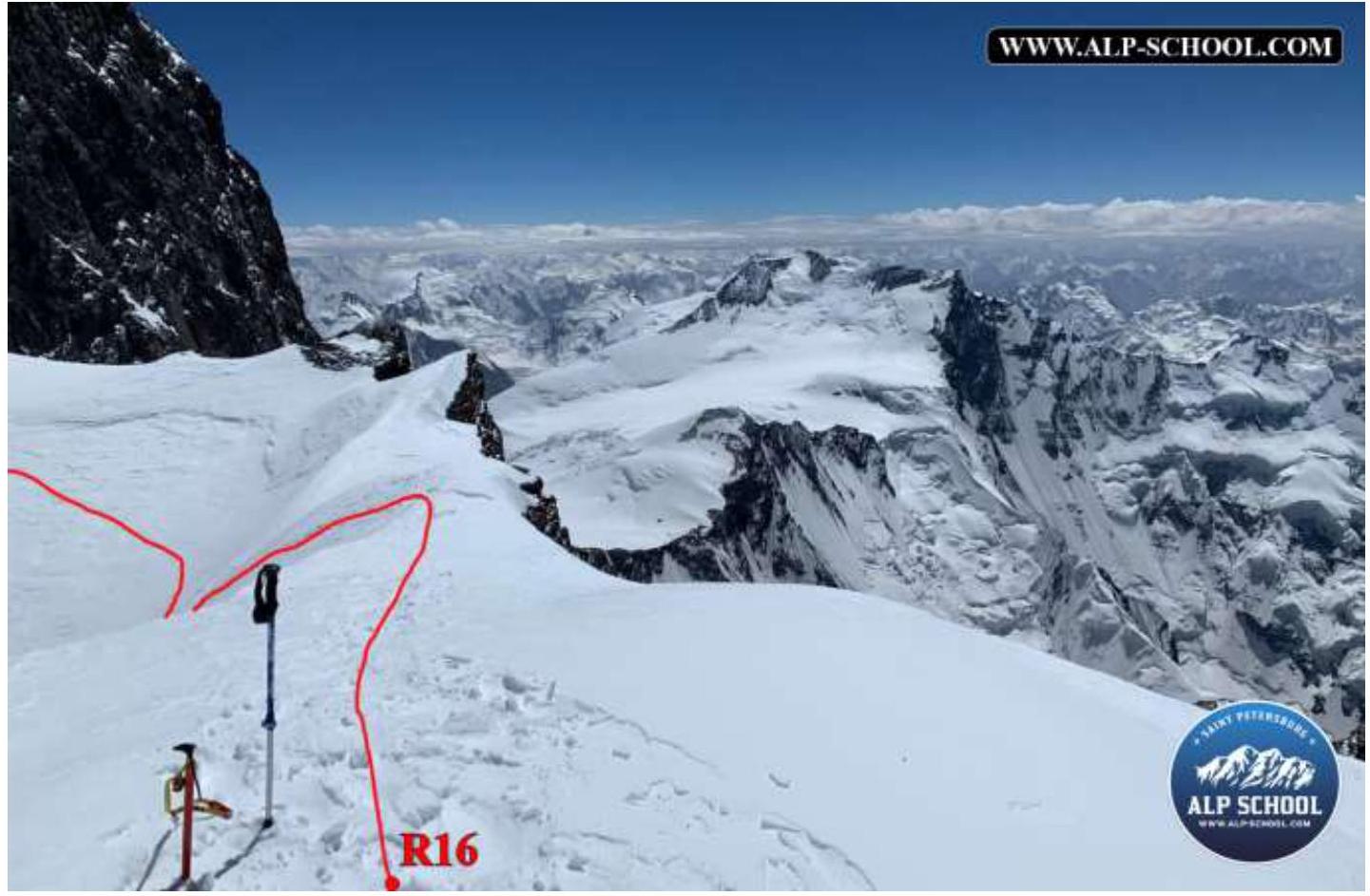
Photo #16
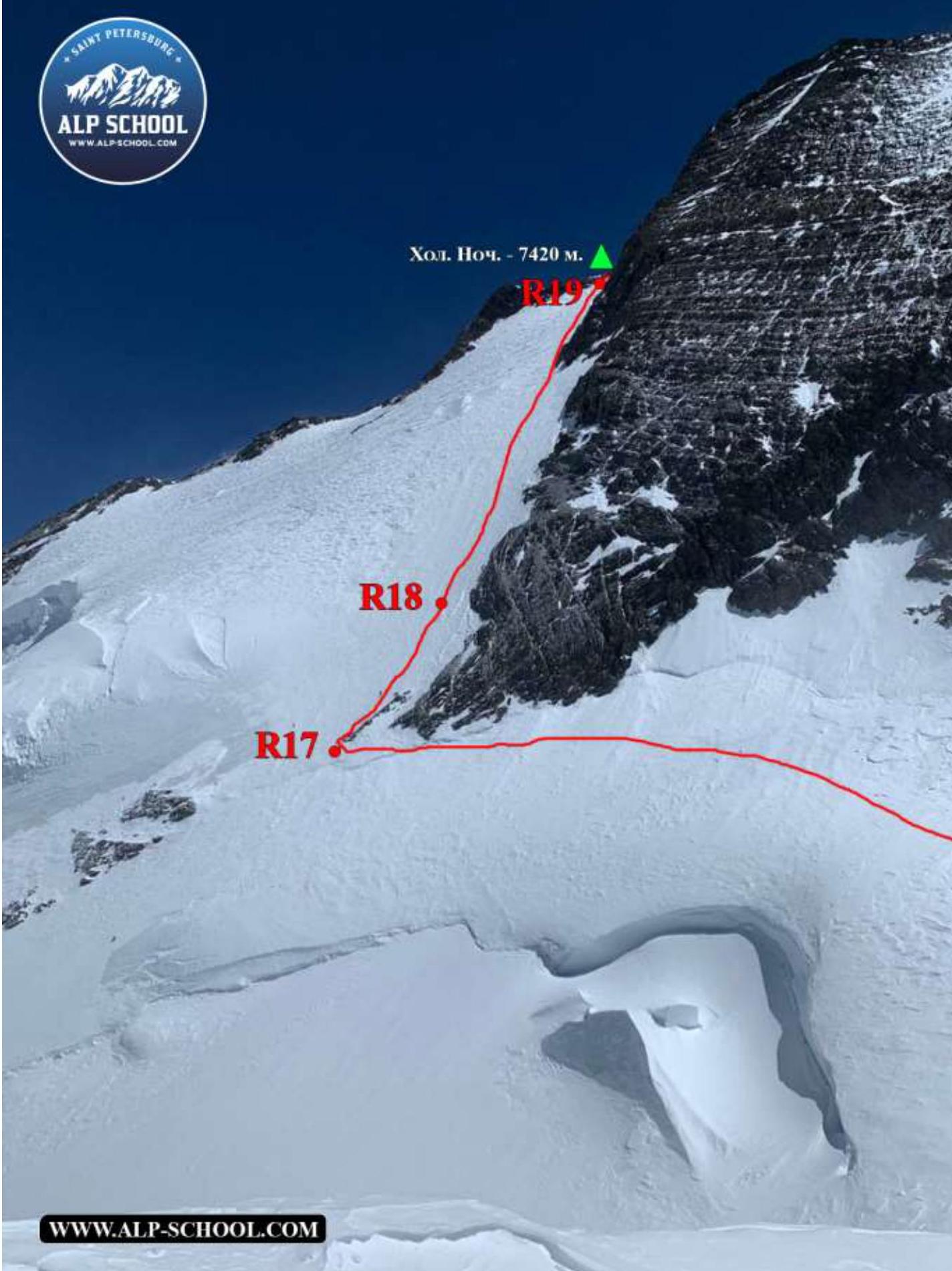
Photo #17
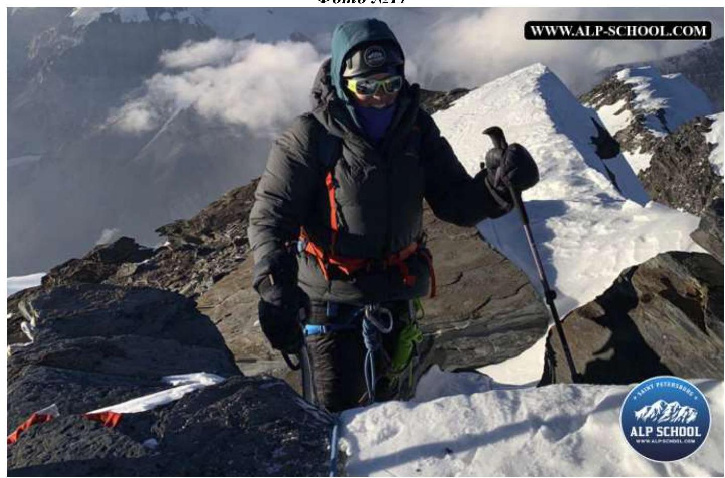
Photo #18 (team "Bars" on the summit)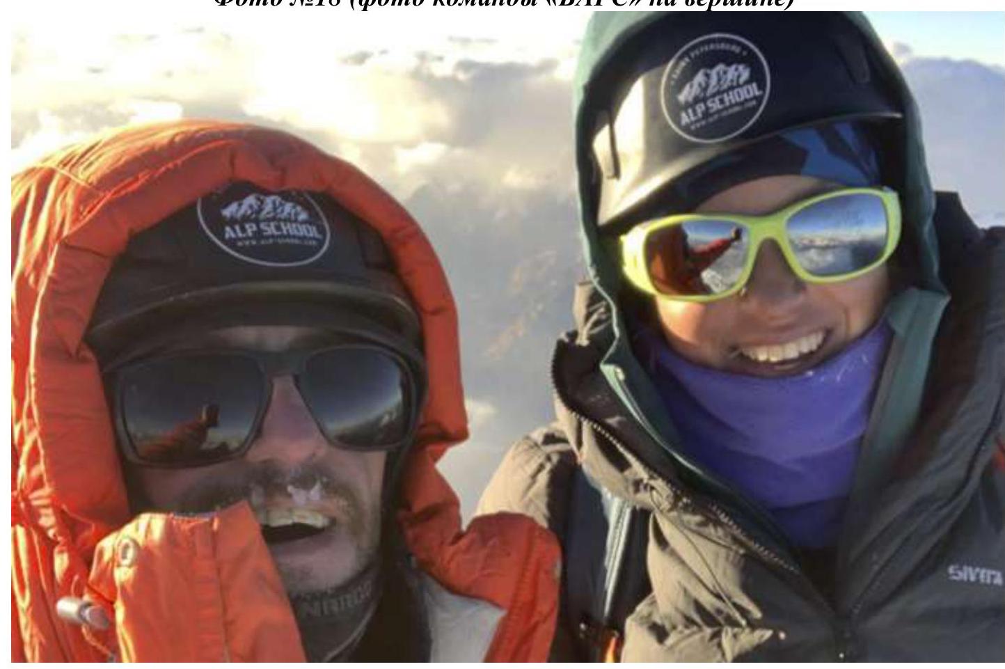
Tactics and Group Actions on the Route
August 10, 2022 (Day 0) – Overnight at 4600 m (Helicopter Pad)
- The group approaches the route at the helicopter pad (4600 meters), where a prior delivery was made. Early rest.
August 11, 2022 (Day 1) – Overnight at 5300 m (C1)
- Early rise. Departure at 3:30 to pass the "pillow" before sunrise. Ascent to C1 (5300 meters) by 8:00. Decided not to ascend higher; set up camp.
August 12, 2022 (Day 2) – Overnight at 6150 m (C2)
- In 2.5 hours, ascended to 5800 meters (approximately 32 minutes per 100 meters). Decided to cross "Grudi" peak (6160 meters). Due to worsening weather and visibility, set up camp at 6150 meters without descending to BPP.
August 13, 2022 (Day 3) – Overnight at 6450 m (C3)
- Descended to BPP and traversed to the ridge of Dushanbe Peak. Mandatory movement in pairs before approaching the ridge due to crevices. Ascended to 6450 meters. Set up camp on the first good site, 50 meters below the usual camp location.
August 14, 2022 (Day 4) – Overnight at 6950 m (C4)
- Due to strong winds, managed to exit the tent only at 11:30. The team was alone on the mountain that day. Ascended to Dushanbe Peak. Visibility was lost in clouds; descended along the ridge towards Kommunizma Peak and set up camp. Prepared gear for the summit.
August 15, 2022 (Day 5) – Overnight at 6950 m (C4)
- No visibility in the morning and throughout the day as forecasted. Wind was not very strong, but visibility was poor. Decided to postpone the summit to the next day. On evening radio contact, learned that three Iranians above them had lost contact for three days. A rescue team was dispatched from below, but it would take several days to reach the stranded climbers. Asked to assist in the rescue.
August 16, 2022 (Day 6) – Overnight at 6950 m (C4)
- Conducted rescue operations in the morning. Reached the stranded climbers by 8:00; assessed their condition, provided first aid, and relayed information to the camp commander. Collected gear, escorted them onto the route, fixed a rope across the bergschrund for ascent to Dushanbe Peak, and guided them down. A rescue team met them on BPP. Returned, checked the route.
August 17, 2022 (Day 7) Summit – Overnight at 7420 m (Cold Biwak)
- Departed for the summit at 6:30. Due to strong winds and deep snow, reached the summit at 18:34. Identified two potential cold biwak sites along the way. Managed to descend to the first identified site by nightfall.
August 18, 2022 (Day 8) – Overnight at 6950 m (C4)
- Wind intensified at night. Weather worsened in the morning; a team member was swept away by wind during descent, along with the belay station. Weather improved slightly during descent on the "spade"; visibility returned, but the wind did not subside. Reached the storm camp by afternoon.
August 19, 2022 (Day 9) – Overnight at 5860 m (BPP)
- Descended to BPP by 13:30 and approached the ascent. Decided not to ascend "Grudi" (about 300 meters) to ensure timely descent to the base camp. Peaceful biwak.
August 20, 2022 (Day 10) – Overnight at base camp
- Ran out of food and gas; had to open emergency rations and a gas canister. Ascent to "Grudi" took about 3 hours, with some fatigue. Returned to the base camp before dinner.
Conclusions
In strong winds:
- It's hard to light a stove; consider bringing a reactor stove;
- Rescue blankets are ineffective, as they're torn apart;
- It's better to bring a proper tent or a frameless tent.
Route safety assessment. The route is generally safe, with the most hazardous sections at the beginning. Early departure is recommended. The "starting" part of the route poses a risk due to potential melting. Fresh snow increases the risk of avalanches along much of the route due to the terrain angle and slope exposure to main wind flows.
There are many convenient camping sites on the slope. It's advisable not to rush, even if the weather permits, and to take time to set up camps at all designated locations.
Radio communication is stable along the route until "Grudi" peak (6160 meters). Beyond that, communication varies until reaching the saddle and starting the traverse to the "spade", where it improves. Water in the form of snow is available throughout the route.
4. Weather Conditions
If you need additional materials: videos, photos, or consultation – feel free to contact us: https://vk.com/alp_school_spb↗


