NW Wall of Peak Kalinina 6565 m
Geographic Description and Sporting Characteristics of Peak Kalinina
Description of Climbing Conditions
Peak Kalinina (6565 m) is located in the Academy of Sciences Range, Central Pamir. Along with Peaks Chetyrekh and Akhmadi-Donish, Peak Kalinina encloses the AYu-Dzhilga valley with a huge rocky-ice cirque.
To the southeast, the massif of Peak Kalinina is quite dissected and is connected by gentle ridges to Peak Zhukova and an unnamed peak 6431 m.
To the northwest, into the AYu-Dzhilga valley, Peak Kalinina drops with a two-kilometer rocky-ice wall.
The first ascent to Peak Kalinina was made in 1972 by a group led by K. Kuzmin from the south, from the Odinnadtsati glacier.
In 1974, a group led by V. Bozhukov, while traversing Peaks Kalinina and Kommunizma, ascended Peak Kalinina via the southeastern ridge, which runs from Peak Zhukova.
Unlike other surrounding mountain regions, the AYu-Dzhilga valley is a relatively infrequently visited area of the Central Pamir. The beginning of mountaineering exploration in the area was made in 1966 by an expedition from Leningrad's "Spartak" led by Budanov. The Leningraders made ascents to Peak Akhmadi-Donish, Peak Chetyrekh, and Peak Yakira from the AYu-Dzhilga valley. Until the 1975 season, this was the only expedition to the valley.

In 1969, a group of climbers from the Dnepropetrovsk expedition, after traversing Peak Babushkina, Peak E. Korzhenevskoi, and Peak Chetyrekh, descended to the AY-Dzhilga glacier and traversed the entire valley.
The materials gathered by the group on the study and photography of the valley's peaks served as the basis for selecting an ascent objective for the combined team of the Dnepropetrovsk Regional Sports Committee in the 1975 season.
The northwest wall of Peak Kalinina is characterized by significant steepness, a large height difference (over two kilometers), and powerful glaciation, especially in the upper part. Hanging glaciers (or ice falls) cover a large part of the wall and significantly complicate the task of choosing an objectively safe route.
Observations of the wall in June and August showed that the highest intensity of ice and rock falls occurs in the second half of July. By the beginning of August, the "activity" of the wall decreases sharply.
A characteristic feature of possible ascent routes up the northwest wall of Peak Kalinina is the alternation of steep rocky walls with ice-snow sections and rocks with snow and rime ice, which creates a particular technical difficulty in passing the wall.
The large number of ice falls poses a serious challenge to climbers in terms of optimal route selection and ascent tactics to ensure group safety.
The rocks composing the wall are diverse: granites, sandstones, shales, and quartz veins. A significant difficulty during the ascent is posed by long and steep sections of unstable shale rocks, which are particularly challenging in terms of organizing reliable protection.
The northwest wall of Peak Kalinina is not exposed to sunlight for the first half of the day. The first rays warm the wall starting around 12:00. Until then, the wall is frozen, but it is the safest for climbing. This circumstance, despite the significant complication of the wall's passage due to intense cold, shifts the climbers' working day towards the early, frosty hours.
As observations showed, weather conditions, rock and ice danger, and a high degree of snow cover make it problematic to ascend the northwest wall of Peak Kalinina before the end of July or the beginning of August.
The group, having started the route on August 9, 1975, spent the first five days ascending in good weather.
On the sixth day, at an altitude of around 6000 m, the group's progress was significantly slowed down by a strong snowstorm that lasted for a day.
The next deterioration in weather caught the group already at the summit of Peak Kalinina, in a bivouac at night. The descent from the summit also took place in heavy snowfall in the upper part and fog and snow in the lower half of the descent route.
Overall, in sporting terms, the northwest wall of Peak Kalinina is a technically complex, extended climbing objective.
Passing the wall, due to its typically combined nature, requires the application of most elements of high mountaineering technique and high moral and physical preparation of the athletes.
The expedition's base camp (4200 m) was located within a 45-minute walk from the start of the route, on a platform between the talus slopes of Peak Yakira and the lateral moraine of the AYu-Dzhilga glacier.
The observation group, along with the rescue team, was stationed at the base camp, from where the entire ascent route was visible.
Map-Scheme of the AYu-Dzhilga Glacier Area

Composition of the Assault Group and Observation Group
| № | Full Name | Year of Birth | Nationality | Sport Rank | Education | Home Address | | : | :------------------------- | :------------ | :---------- | :--------- | :-------- | :------------------------------------- | | | | | | | | |
Assault Group
- KOZAK Leonid Romanovich | 1941 | Ukrainian | CMS | Higher | Dnepropetrovsk-59, pr-t Kirova, 102, kv. 35 |
- SAMOILENKO Vasily Iosifovich | 1936 | Ukrainian | CMS | Higher | Dnepropetrovsk, ul. Moskovskaya, 25, kv. 12 |
- ZYUZIN Vadim Alexandrovich | 1940 | Russian | CMS | Higher | Dnepropetrovsk, ul. Universitetskaya, 2, d. 4, kv. 12 |
- ORLOV Oleg Leonidovich | 1940 | Ukrainian | CMS | Higher | Dnepropetrovsk, pr-t Kirova, 82, kv. 43 |
- LITOVCHENKO Yuri Kirillovich | 1939 | Ukrainian | CMS | Higher | Dnepropetrovsk, ul. Pravdy, 10, kv. 1 |
Observation Group
- PETRICHENKO Nikolai Nikolaevich | 1944 | Ukrainian | CMS | Higher | Dnepropetrovskaya obl., Dnepropetrovsk, 320031, ul. Novofrunzenskoe, 20, kv. 1 |
- LYASHENKO Alexey Mikhailovich | 1948 | Ukrainian | CMS | Higher | Dnepropetrovskaya obl., Krinichansky r-n, s. Vetrovka |
Description of the Ascent
August 9. First Day.
At 1:00, two teams consisting of Kozak L. — Litovchenko Yu. and Zyuzin V. — Orlov O. left the base camp at 4200 m to process the lower part of the wall. At 2:45, they approached the start of the route.
60 m along the snow at 30°, then 45°. Movement was simultaneous until the bergschrund. Crampons were put on below the bergschrund; above, it was ice.
Crossing the bergschrund via a snow-ice bridge. Further, 20 m of step cutting under a rocky outcrop, 1 ice screw. Above, 120 m of a steep ice slope with individual rocky outcrops. 4 rock and 12 ice screws were hammered. Exit to a small ledge at the base of the wall. From here, a 160 m wall rises vertically with an average steepness of 80° and individual overhangs.
Yura Litovchenko goes up first. He works on the rocks easily and quickly. Climbing ranges from difficult to extreme. Ladders are hung under two cornices. On the second 40 m section, the path was blocked by a flat slab with rime ice, where another ladder was hung.
On a small ledge between the ropes, we immediately hammer in anchors for the station to pull up the backpacks. We process another 80 m of the wall. The route hardly deviates from the vertical. The second 80 m section features slightly more dissected rocks, and climbing is easier; however, it's not passable with backpacks. By 18:00, we finish hanging the ropes and organizing 4 stations for receiving backpacks. We quickly descend. At 19:30, the group returns to the 4200 m camp.
August 10. Second Day.
We wake up early at 5:00. At 6:00, after receiving final guidance and wishes, we leave our cozy 4200 m camp. At 6:45, we approach the route, put on crampons, and at 7:00, we begin moving along the processed ropes. We tie 4 ropes together, coil them into a bundle, and throw them down. Today, the guys will pick up the rope.
So, "the bridges are broken," and we have two kilometers of wall ahead of us. Without delay, we start working. Today is a challenging day. We need to move as far as possible to cross the ice couloir the next day before rocks start falling.
In the morning:
- We put on as much as possible to lighten our backpacks.
- 160 m of hard labor.
- Our new backpacks get their first punctures.
- It was particularly difficult on the last 40 m, where backpacks often got stuck under cornices.
Finally, by 14:30, the last backpack lands on a small ledge, where we take a short rest: we rest, quench our thirst and hunger.
At 15:20, we continue up the 40 m ice slope — the right part of a large snowfield, resembling a huge bird with outstretched wings in the photo. Above the ice begins the upper part of the black wall.
Up 40 m along steep but heavily dissected rocks. Then the steepness increases. To the left along the wall, an indistinctly expressed ledge leads diagonally upwards.
Along the ledge with individual 2–3 meter wall steps, 100 m upwards along rock outcrops. The first person goes without a backpack. In many places, he is thrown off. We cross a small, 10–12 m steep wall.
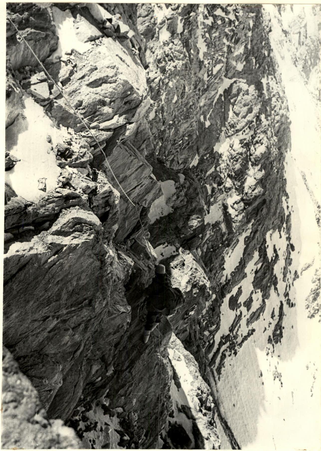
Upper part of the black wall. The ice couloir and large-block rocks lead to the upper edge of the black wall, left and above the 80 m left wing of the snowfield "Bird." 25 m of snow at 45–50° and exit to an inclined ledge under the base of a buttress. Above the ledge, the wall is 40 m; beyond it, an ice slope is visible. It's pointless to continue today. We build a platform.
Exhausted, we settle into our "high-altitude" bivouac with sufficient comfort. At 21:00, we fire a flare, receive a response, and within 30 minutes, we are asleep. Tomorrow is an early rise.
August 11. Third Day.
Rise at 5:00. As hard as it is to get up so early on a wall frozen by night frost, we practiced such early rises throughout the ascent (except for the day of bad weather). At 5:50, the Orlov—Zyuzin team starts processing the route. The others prepare breakfast and pack backpacks. This division of labor was used repeatedly later on.
At 6:20, the guys return. We have breakfast and by 7:00, everyone is on the route.
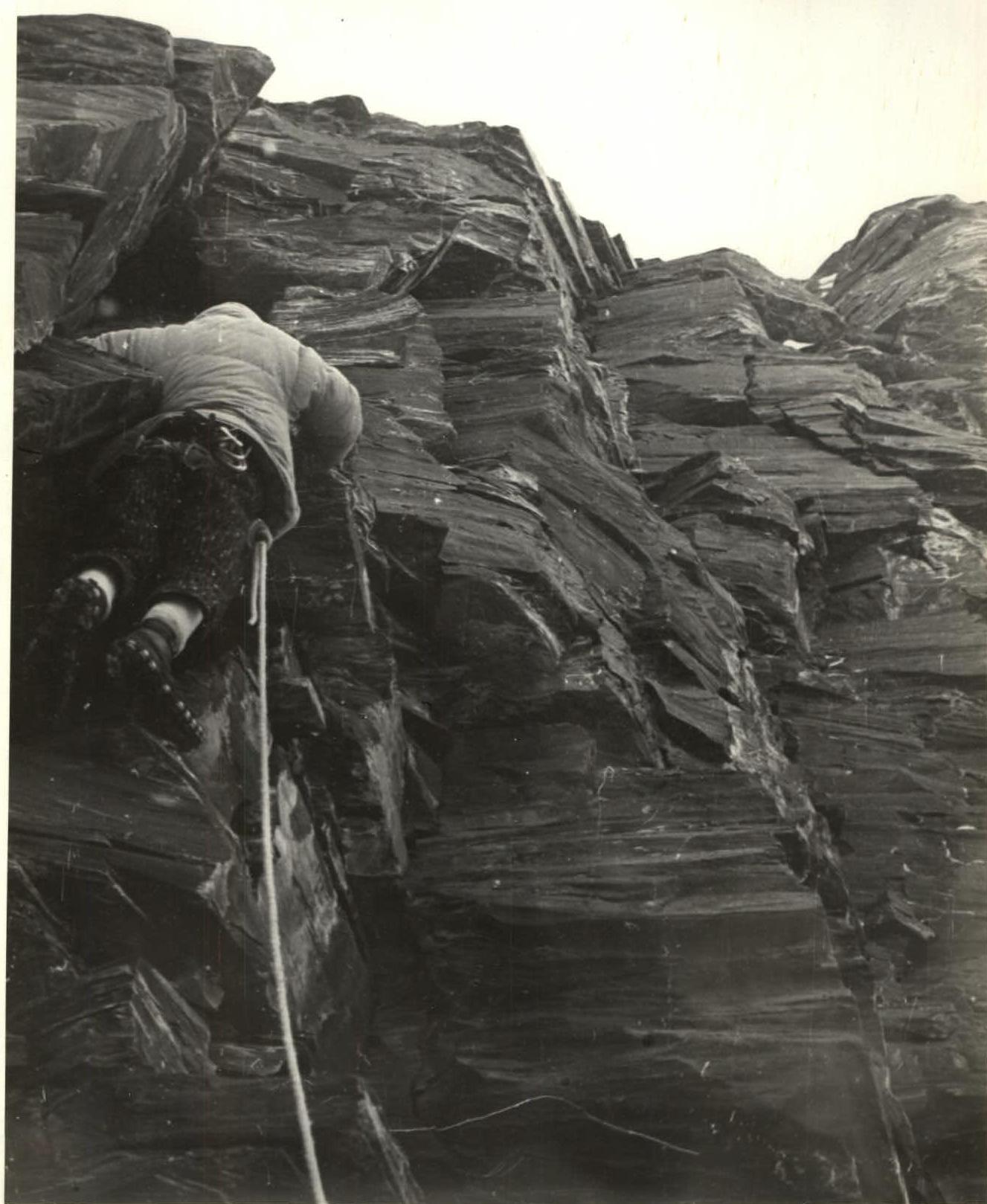
40 m above the tent, an ice section begins with rock outcrops over about 120 m. The first person goes in crampons. For protection, rock and tubular ice screws are used evenly. The ice slope ends with a 40–50 meter wall, quite steep. Here, we first experience the full difficulty and tension of overcoming a very unstable, steep wall.
To organize a secure anchor, we have to remove and pry out a dozen flat stones. Long titanium wedges, hammered directly into the rock, come to our rescue. Judging by the time Vadim Zyuzin spent hammering them, they held well.
At 9:30, we reach the planned spot to cross the ice couloir.
Within an hour, the first person, without a backpack, crosses the couloir, cutting steps. After 40 m, a rope is fixed, and intermediate ice screws are clipped out of the carabiners. We tie the ropes together and continue crossing the couloir.
To speed up the passage on the return, intermediate screws are removed, except for one central one.
At 11:30, the entire group crosses the couloir and reaches the base of the red quartz band.
We accomplished the task of early couloir crossing; within 1–1.5 hours, rocks will start falling along the couloir.
Upwards, a uniformly steep, about 70°, red wall, around 200 m, with quartz band outcrops. In the upper part, there are sections of steep ice, rime ice, and snow.
The wall should end with a ledge and a snowfield. On quartz bands and shales, there are again difficulties with organizing protection.
Before exiting onto the ledge:
- 30 m of very difficult climbing
- traverse along rime ice under an overhang
With backpacks, this section is passed with extreme physical effort. By 16:00, we enter the ledge. On the ledge, there's a convenient snow pocket with a practically ready-made platform.
We camp under the base of a huge, concave black wall, below and to the left of the right ice fall. The wall is impassable head-on due to large, hanging "live" blocks. We decide to pass it along the left edge, which starts right from the campsite.
We set up a bivouac and simultaneously process the edge of the wall. Smooth, large-block rocks with cornices. We hang 2 ladders when passing the cornices.
Then:
- 40 m of a gentle section (about 50°);
- again steep rocks, but with a sufficient number of holds.
We process up to three ropes in the dark.
August 12. Fourth Day.
Rise at 5:30, departure at 8:00. Severe frost. We decide to pass the first 40 m with backpacks to save time. At the second overhang, we had to hang an additional ladder; with a backpack, we were thrown off, and our hands couldn't hold.
We pass the processed ropes relatively quickly. After 120 m of rocks of medium difficulty with sections of complex climbing, we enter a small, the size of a tent base, completely smooth rock platform on the edge of the wall. We regret not having earned a night's rest yet. We take a short rest and continue upwards along gentle, very unstable shale rocks for about 80 m.
Then the steepness of the edge increases sharply to 75°. Again, enormous tension, extreme caution, and gentle loading of each foothold. Then the steepness increases again to 80° — about 40 m above; a ledge is visible. Litovchenko removes his backpack, puts on galoshes to better "feel" the shale. He hits many hooks, but we feel it's due to their insufficient reliability. Finally, a sigh of relief: "The railing is ready!" By 18:00, the last participant enters the platform with snow, where the tent is perfectly set up. Although there was still daylight, fatigue didn't allow us to process the route further that evening. We reached the level of the right ice fall.
August 13. Fifth Day.
We depart at 8:10. Upwards, there's about 140 m of a uniformly steep, about 70°, rock ascent. The character of the rocks is dissected, with a sufficient number of holds. In some places, the rocks are covered with rime ice. We have to cut the ice — otherwise, it's impassable. This takes a lot of time. In the upper part, the steepness of the rocks decreases slightly, but dry snow and ice under the snow greatly complicate the movement. On the snow, the morning frost is particularly felt. We eagerly await the sun's appearance. The entire valley is already warmed by its rays.
The first large snowfield is quite steep, and the first surprises:
- Snow structure is very uneven — sometimes dense, sometimes deep and loose snow with an ice base. We have to move in zigzags, choosing strips of more or less reliable snow.
- The snowfield turns into steep blocky rocks covered in snow.
- In the upper part, there's a snow cornice above a section of about 20 m of steep snow with ice outcrops. Cracks and holds are extracted from under the snow. Often, we have to chop away wall ice with an ice axe or hammer. Although we work almost the entire day in the snow, our clothing and footwear remain almost dry. It's cold even with the sun out.
At 16:00, the group gathers above the cornice on a small snow-ice knife under the base of an 80-meter steep wall. Apparently, it's unlikely we'll find a suitable spot for a bivouac above soon. Beyond the wall, there's steep snow with smoothed rocks, intersected from left to right by a ridge of vertical rocks. We cut out a platform and process the wall. The character of the rocks is again large-block with overhangs. We hang 80 m of rope in the dark. Climbing is very difficult, sometimes extreme. We hang ladders in two places.
August 14. Sixth Day.
Rise, as always, at 5:00. However, we manage to leave the tent only by 9:00. Boots, despite all precautions, are absolutely frozen and can only be put on after thawing on a primus stove. This operation takes us at least 1.5 hours. It's very cold. We pass the hung two ropes. Another 10 m, and the wall turns into a steep snow field with outcrops of smoothed rocks like "ram's foreheads." We are to the right of the left ice fall.
Under the cover of an inclined rock wall — a ridge, we should move upwards to the right, bypassing the icefall. 180 m along the base of the wall on steep, loose snow using rock screws for protection.
Then, about 60 m upwards on loose snow with sharply changing depth and density — to the base of a vertical wall of large-block structure.
By mid-day, the weather starts to deteriorate noticeably. In the morning, we noticed a front of cirrus clouds, which, unfortunately, did not deceive our expectations.
At 17:30, we are under the wall; it's snowing. A bivouac under the wall can only be a sitting one, which is completely unacceptable in such weather. We decide, without wasting time, to climb to the top of the wall, where there should be a more or less suitable platform.
The Litovchenko—Kozak team, without backpacks, climbs to the top with an intermediate protection point: the rope is 15 m short of the upper edge of the wall. Climbing is very difficult, greatly complicated by the intensifying snowfall. 2 ladders are used. At 18:30, we begin the ascent with backpacks. First, the tent and primus stove go up. Snow has covered all the ledges and holds. The last participant climbs to the already set-up tent at 20:40. We fire a green flare downwards towards the base camp with a faint hope that the guys will hear the shot or see the green glow in the clouds. We had to cut out a couple of cubic meters of ice and snow for the tent.
The upper edge of the tent is below the level of the snowfield. This circumstance eased the struggle with small avalanches that came down all night: the snow slid over the tent. We slept very poorly, constantly having to shake snow off the top of the tent. The snowfall did not decrease throughout the night. By morning, the wind strengthened, but the snow continued.
August 15. Seventh Day.
There was no awakening as such. Sleep with frequent interruptions continued until around 9:00. Some hope for weather improvement appeared with the strengthening wind. Indeed, by 12:00, the intensity of the snowfall decreased sharply. We decide to use the remaining time to process the route. From the tent
Relief of the upper third of the NW wall of Peak Kalinina. Zyuzin and Orlov were the first to climb out. Sinking almost waist-deep into fresh snow, the duo began moving towards the last rocky ridge on the way to the summit ridge. The rocks, in the form of large blocks of 2–3 m, rise in steps. The platforms between the blocks are completely filled with snow. Zyuzin and Orlov processed 2 ropes and descended to the tent. They were replaced by the Kozak—Samoyленко team, which processed another 1.5 ropes to the start of the snow ascent of the ice dome of the summit. By 18:00, they descended to the tent. The snowfall had almost stopped. By night, we saw a black sky with silver stars. Tomorrow will be good weather!
August 16. Eighth Day.
The night was frosty. Again, a lot of time is spent thawing boots on a primus stove. At 9:30, the first team departs along the hung railing. At 10:20, the tent is taken down, and the entire group is on the move. It's very cold. Frozen tricouni knock against the rocks: we warm our feet. At 11:00, from behind the icefall, the saving rays of the sun appear. Snow-covered steep rocks lead to snow, to the right of the icefall. Initially, the snow is dense, then it abruptly turns into a loose structure. On a rocky outcrop, it's possible to hammer in a good intermediate hook. We cross two crevasses. The second one is in the form of a bergschrund with a significant height difference between the upper and lower sides. A steep (up to 80°) ice bridge. 2 ice screws are screwed in. A ladder is hung on the upper screw to avoid cutting steps in the bridge. Beyond the crevasse, the steepness of the snow increases to 60°. The snow is very loose and deep.
We dig a trench, often changing the lead. We cross another wide, about 1.5 m, crevasse on a bridge. The steepness of the snow doesn't
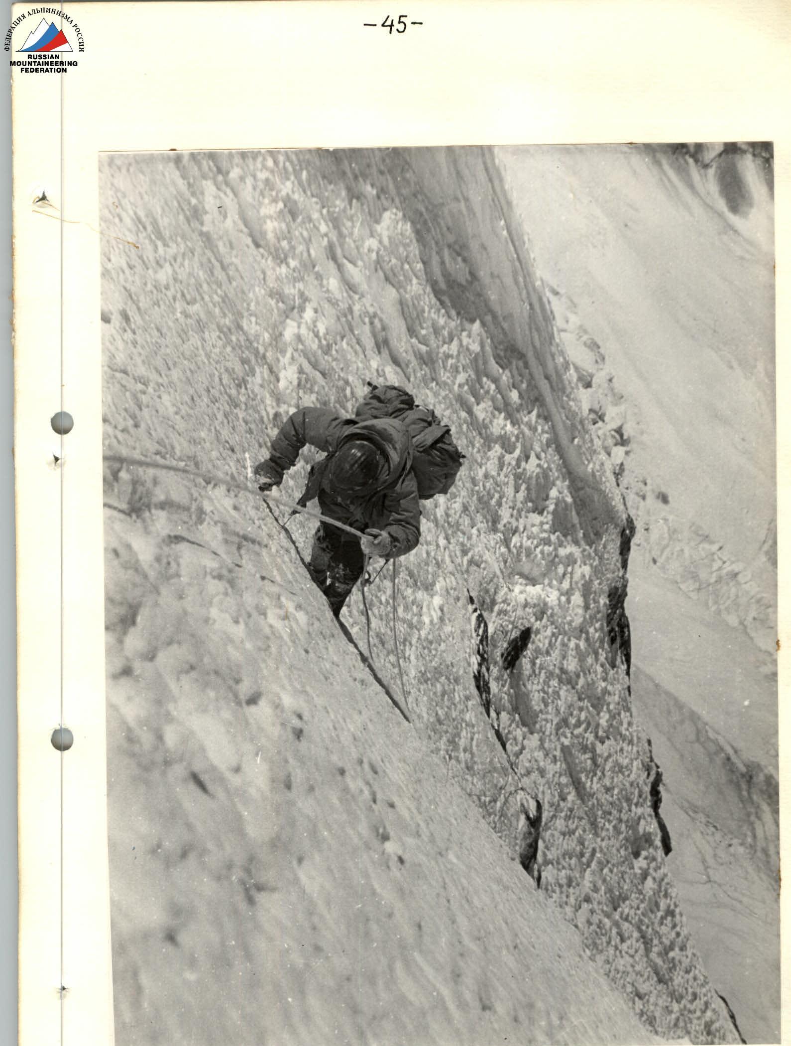
Section 26. decrease. We continue digging a trench for the second 40 m. By 17:00, it becomes clear that we won't make it to the ridge before nightfall. We decide to cut out a platform on the edge of the crevasse on the lower step. The team continues moving upwards until 19:00. An ice axe is hammered into the bottom of the trench, and the railing is secured. At 19:30, we set up the tent. At 21:00, after receiving a response flare from below, we go to sleep.
August 17. Ninth Day.
By 10:00, the first team manages to leave the tent and move along the processed ropes. At 10:45, we take down the tent. The entire group is on the move.
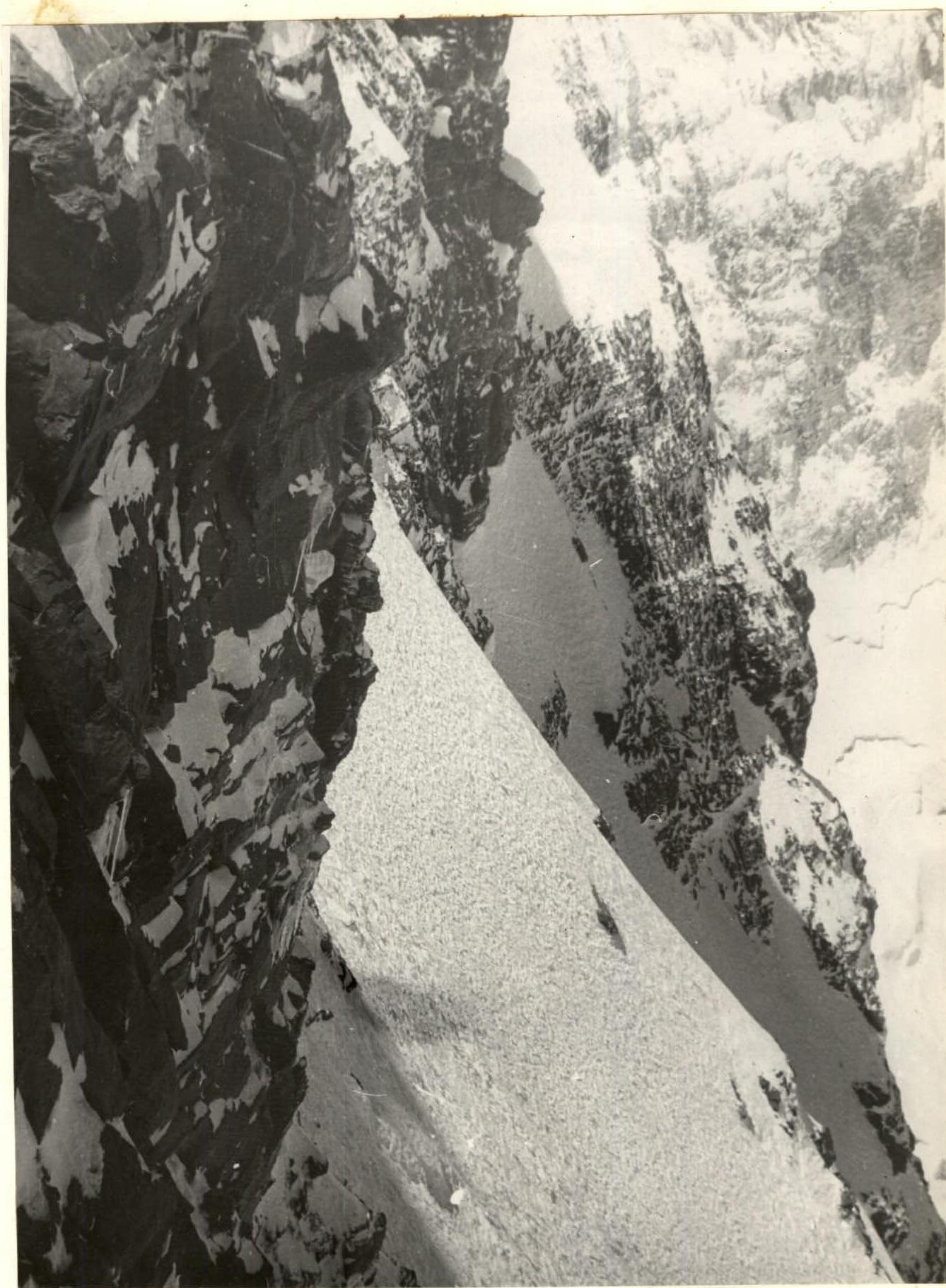
Above the processed ropes, another 60 m is traversed by digging a trench. Then, finally, the steepness of the snow begins to decrease. Gradually, its density increases, and finally, we see Vadim Zyuzin confidently cutting steps in the snow crust. Despite the altitude (around 6300 m), we move quite quickly and with pleasure along the dense and, for the first time in many days, reliable snow, and by 15:00, we reach the summit ridge.
We rest for about 40 minutes, admiring the vast accumulations of Pamir peaks. Then we slowly (fatigue and altitude were taking their toll) begin moving towards the summit. The ridge is not steep, but there are hidden crevasses. To the left, to the southeast, there are huge cornices and ice falls.
At 18:00, we reach the summit. The wall is conquered! We fire a flare towards the camp. We retrieve the note left by V. Bozhukov's group. We observe the descent route to the col with Peak Akhmadi-Donish. We bivouac on the summit.
At night, we woke up to the sound of the tent flapping. Outside, a storm was raging: heavy snow with wind. In the morning, the weather improved slightly. The snow was weak, but the wind didn't subside.
On October 19, at 10:00, we began our descent to the col. We reached the col at 13:00. After a short rest, we continued downwards. By nightfall, we had traversed about half of the height difference to the glacier.
At 20:00, we set up the tent on a ledge on a rocky buttress of the col. At 5:00, as soon as it got light, we resumed our descent. By 9:00, we were on the glacier.
The ascent is complete.

Descent Path
Table of Main Characteristics of the Ascent Route
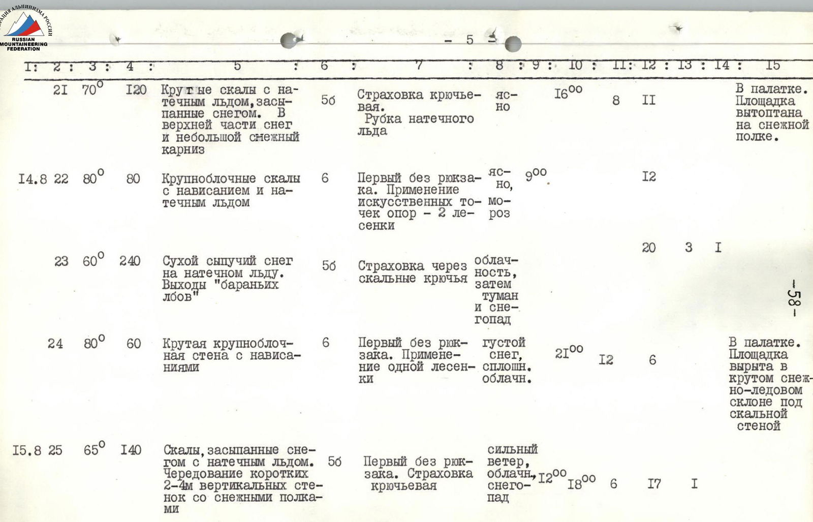
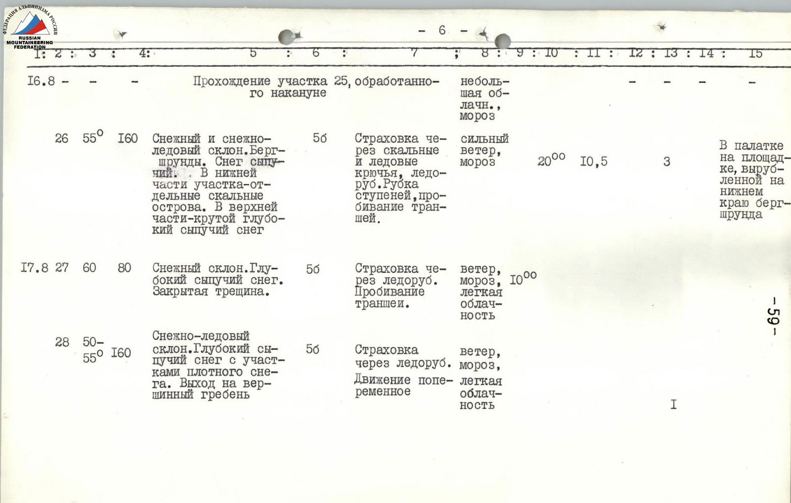
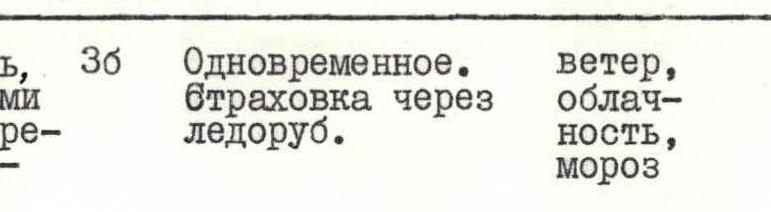
Ascent route — Peak Kalinina via the northwest wall. Height difference of the route — 2315 m. Including the most complex sections — 1050 m. Average steepness of the route — 65°. Steepness of the most complex sections — 70–85°. Hammered in: 217 rock, 38 ice, 4 piton screws.
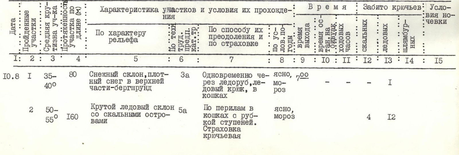
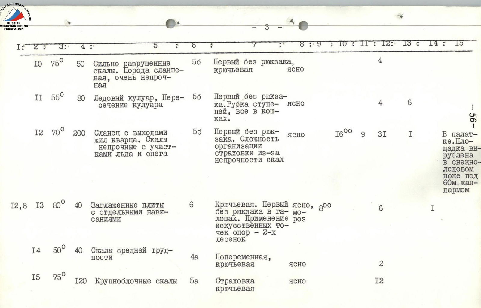
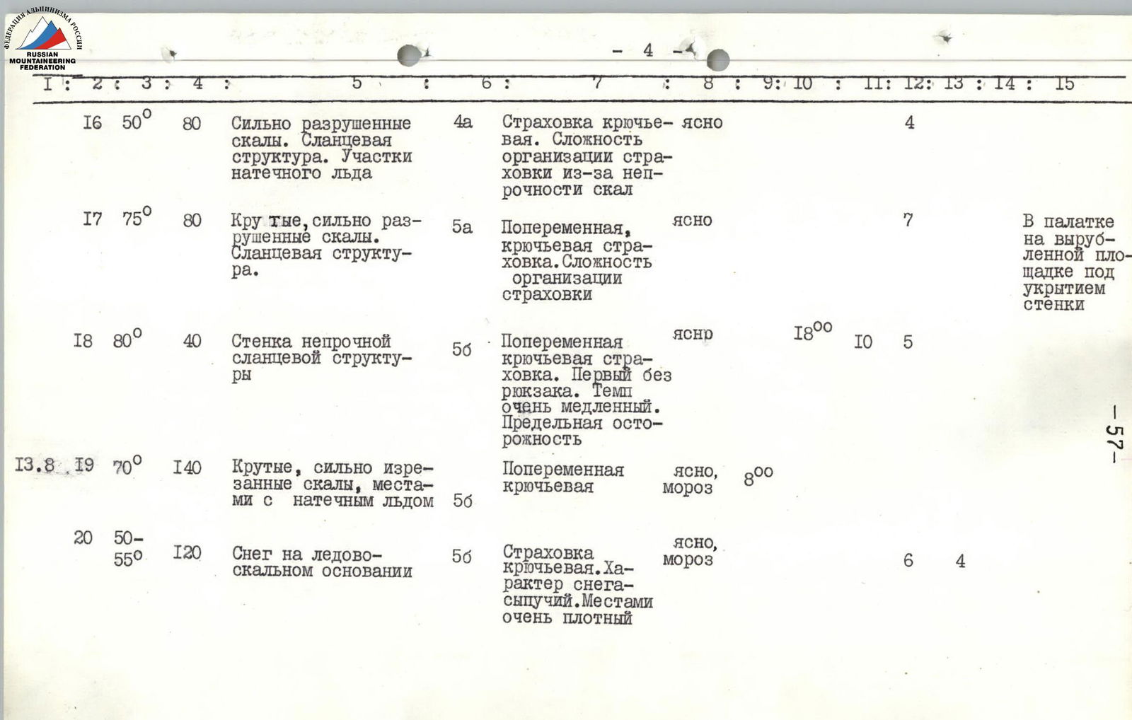

| Date | Section | Average Steepness of Section | Length of Section, m | Relief Characteristics | Tech. Level | Method of Passage and Protection | Time: Weather Conditions | Time: Departure | Time: Bivouac | Time: Climbing Hours | Rock Screws Hammered | Ice Screws Hammered | Piton Screws Hammered | Bivouac Conditions |
|---|---|---|---|---|---|---|---|---|---|---|---|---|---|---|
| August 10 | R1 | 35–40° | 80 | Snow slope, dense snow in upper part—bergschrund | 3А | Simultaneously, via ice axe, ice screw, in crampons | clear, frost | 7:00 | 1 | |||||
| R2 | 50–55° | 160 | Steep ice slope with rocky outcrops | 5А | Along fixed ropes in crampons with step cutting. Hook protection | clear, frost | 4 | 12 | ||||||
| R3 | 80–85° | 80 | Rocky wall. Character—large-block rocks with individual negative sections. Rime ice | 6 | Passed without backpacks, in galoshes. Hook protection with 3 ladders. Backpacks pulled up | clear, frost | 16 | 2 | ||||||
| R4 | 75° | 80 | Large-block rocks | 6 | Without backpacks. Backpacks pulled up. Hook protection, 1 ladder | clear | 12 | |||||||
| R5 | 45° | 40 | Ice slope | 4А | Hooks, first in crampons | clear | 2 | 2 | ||||||
| R6 | 60° | 40 | Destroyed rocks | 4Б | Hooks | clear | 4 | |||||||
| R7 | 70° | 100 | Traverse of wall with height gain. Large-block rocks | 5Б | First without backpack, hook protection | clear | 19:00 | 12 | 10 | In tent under wall about 40 m. Platform built | ||||
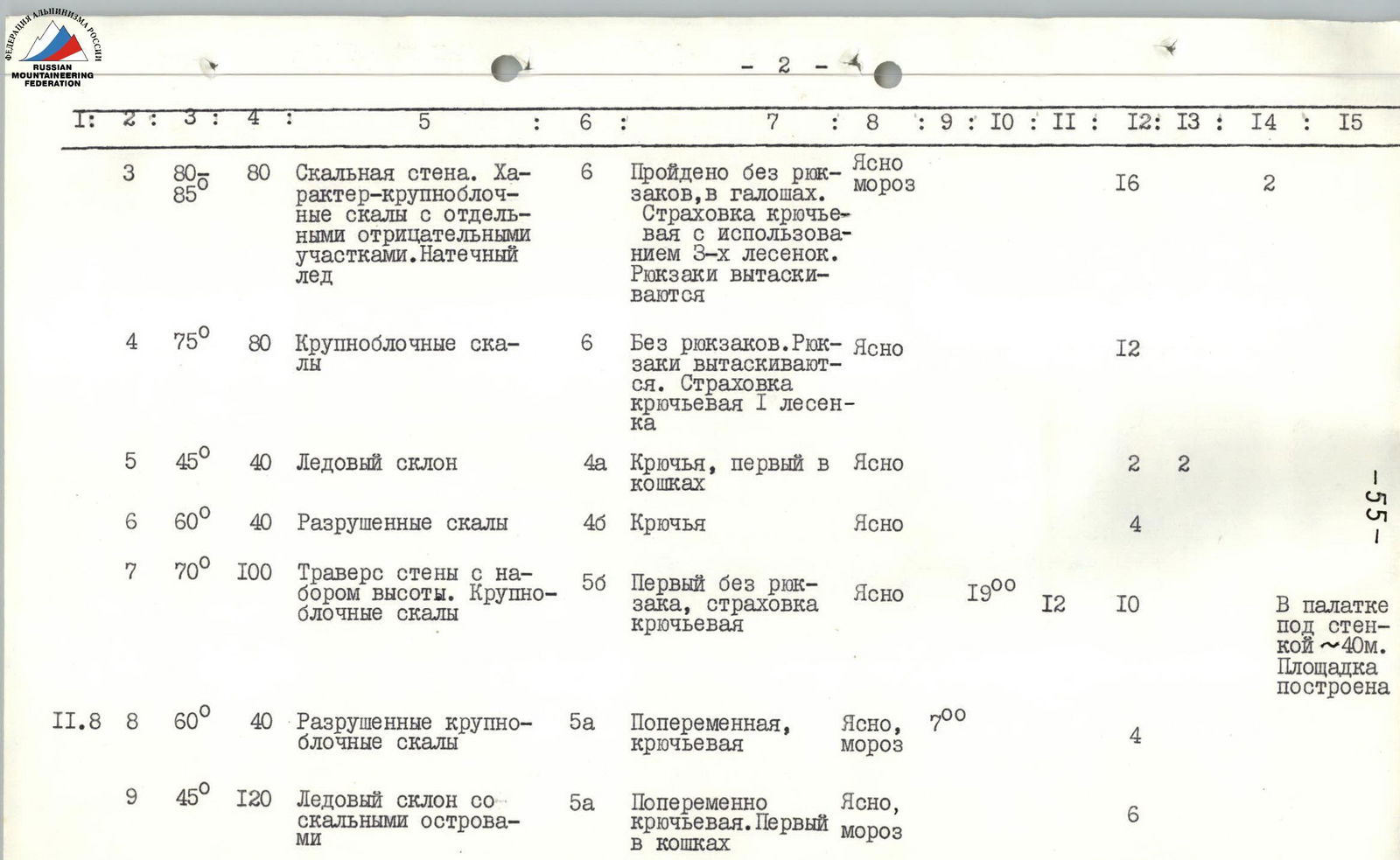
| August 11 | R8 | 60° | 40 | Destroyed large-block rocks | 5А | Alternate, hook protection | clear, frost | 7:00 | 4 | |||||
| R9 | 45° | 120 | Ice slope with rocky outcrops | 5А | Alternate hook protection. First in crampons | clear, frost | 6 | |||||||
| R10 | 75° | 50 | Highly destroyed rocks. Shale structure, very unstable | 5Б | First without backpack, hook protection | clear | 4 | |||||||
| R11 | 55° | 80 | Ice couloir, crossing couloir | 5Б | First without backpack. Step cutting, all in crampons | clear | 4 | 6 | ||||||
| R12 | 70° | 200 | Shale with quartz vein outcrops. Rocks unstable with ice and snow sections | 5Б | First without backpack. Difficulty in organizing protection due to rock instability | clear | 16:00 | 9 | 31 | 1 | In tent. Platform carved in snow-ice knife under 60 m rock outcrop | |||
| August 12 | R13 | 80° | 40 | Smooth slabs with individual overhangs | 6 | Hook protection. First without backpack in galoshes. Use of 2 ladders | clear, frost | 8:00 | 6 | 1 | ||||
| R14 | 50° | 40 | Rocks of medium difficulty | 4А | Alternate, hook protection | clear | 2 | |||||||
| R15 | 75° | 120 | Large-block rocks | 5А | Hook protection | clear | 12 | |||||||
| R16 | 50° | 80 | Highly destroyed rocks. Shale structure. Sections of rime ice | 4А | Hook protection. Difficulty in organizing protection due to rock instability | clear | 4 | |||||||
| R17 | 75° | 80 | Steep, highly destroyed rocks. Shale structure | 5А | Alternate, hook protection. Difficulty in organizing protection | clear | 7 | In tent on carved platform under rock cover | ||||||
| R18 | 80° | 40 | Wall of unstable shale structure | 5Б | Alternate hook protection. First without backpack. Very slow pace. Extreme caution | clear | 18:00 | 10 | 5 | |||||
| August 13 | R19 | 70° | 140 | Steep, heavily dissected rocks, partially with rime ice | 5Б | Alternate hook protection | clear, frost | 8:00 |


